
viewtopic.php?f=25&t=102811
Forecast challenge!
ATL HANNA: Extratropical - Discussion
Moderator: S2k Moderators
-
beaufort12
- S2K Supporter

- Posts: 70
- Joined: Thu Sep 02, 2004 9:18 am
- Location: Lorton VA
Re: Tropical Depression Eight in Central Atlantic
yes,this has been around for awhile now, in the background refusing to fade away and leave us alone. maybe fay and gustav have been the focus of attention, but bang, there is a new big worry now. in the back of my mind it makes me think that moving my mother from port st lucie might have been a stroke of good timing.
0 likes

-
bob rulz
- Category 5

- Posts: 1711
- Age: 35
- Joined: Sat Jan 28, 2006 7:30 pm
- Location: Salt Lake City, Utah
Re: Tropical Depression Eight in Central Atlantic
HURAKAN wrote:bob rulz wrote:beaufort12 wrote:i believe this morning will see some very suprised people
This thing developed pretty rapidly. As far as I know it wasn't even being mentioned in the media yesterday (well, I don't know about local Florida news).
We have been tracking it for at least a week. It took its time due to shear and dry air.
Oh I know. But once it started getting going yesterday it got itself together pretty quickly, and therefore to most of the general population it will have seemed like it came out of nowhere. This small disturbance likely wasn't considered enough of a threat to mention in the media (although again I don't know about the local Florida media).
0 likes
-
Blown Away

- S2K Supporter
- Posts: 10253
- Joined: Wed May 26, 2004 6:17 am
Re: Tropical Depression Eight in Central Atlantic
AREA FORECAST DISCUSSION
NATIONAL WEATHER SERVICE MELBOURNE FL
445 AM EDT THU AUG 28 2008
.DISCUSSION...
NEXT WEEK...IT APPEARS THAT THE ECM RUNS OF THE PAST FEW NIGHTS YET
AGAIN HAD THE RIGHT GENERAL IDEA W/R/T THE SYNOPTIC PATTERN OVER THE
ERN CONUS-WRN ATLC AS THE MORE RELIABLE GLOBAL MODEL GUIDANCE HAS
TRENDED TWD ITS SOLNS...BOTH SFC AND ALOFT. HOWEVER...THERE STILL
REMAINS SOME PRETTY SIGNIFICANT DIFFERENCES W/R/T THE EVOLUTION OF
THE STRONG ERN CONUS DLM RIDGE AND A DEEP LYR CUTOFF LOW INITIALLY
OVER OVER THE CNDN MRTMS WHICH DROPS SOUTH OR SSE OVER THE WRN ATLC.
DEPENDING ON WHICH MODEL YOU TRUST MORE...THIS LARGE RIDGE WILL
EITHER 1) PUSH EASTWARD INTO THE WRN ATLC...SHOVING THE LOW ESE-WD
MORE TWD THE CTRL ATLC (GFS); OR 2) REMAIN OVER THE ERN CONUS AS THE
DEEP LYR LOW DROPS SOUTH TO SSW OVER THE WRN ATLC (ECM).
EVEN WITH THESE EVOLVING DIFFS...WHAT DOES APPEAR LKLY FOR MUCH OF
NEXT WEEK IS THAT A FAIRLY EXPANSIVE SFC HIGH PRES RIDGE WILL HOLD
SWAY OVER THE ERN CONUS...WHICH WILL KEEP ECFL IN A PD OF MDT TO
PSBLY BRISK LOW LEVEL EASTERLIES...WHICH HAS BEEN IN ABSENTIA FOR
ALMOST THE ENTIRE SUMMER. FCST WILL CONTINUE REGIME OF LATE NIGHT
AND EARLY MORNING SHRA WITH LOW END SCT POPS CONTINUING THROUGH THE
AFTN. SHOULD EASTERLIES BE AS BRISK AS FCST...SHRA WILL BE MORE
PREVALENT THAN TS.
THE BIG UNCERTAINTY IN THE FCST...ESPECIALLY FOR DAYS 6-7...IS HOW
THE AFOREMENTIONED DEEP LAYER FEATURES AFFECT THE EVENTUAL TRACK
AND INTENSITY OF NEWLY FORMED T.D. #8. INITIAL FCST TRACK TAKES
IT NW...THEN TURNS IT WNW TO WEST IN THE GENERAL DIRECTION OF THE
BAHAMAS BY EARLY NEXT WEEK AS IT STRENGTHENS INTO A HURRICANE. WE
WILL BE WATCHING THIS CLOSELY. REFER TO NATIONAL HURRICANE CENTER
PRODUCTS REGARDING TROPICAL DEPRESSION EIGHT.
Pretty much the first brisk easterlies I've seen all summer.
Last edited by Blown Away on Thu Aug 28, 2008 5:10 am, edited 1 time in total.
0 likes
-
HURAKAN

- Professional-Met

- Posts: 46084
- Age: 39
- Joined: Thu May 20, 2004 4:34 pm
- Location: Key West, FL
- Contact:
Re: Tropical Depression Eight in Central Atlantic
bob rulz wrote:Oh I know. But once it started getting going yesterday it got itself together pretty quickly, and therefore to most of the general population it will have seemed like it came out of nowhere. This small disturbance likely wasn't considered enough of a threat to mention in the media (although again I don't know about the local Florida media).
I remember seeing it being mentioned a few days ago in NBC and CBS.
0 likes
-
deltadog03

- Professional-Met
- Posts: 3580
- Joined: Tue Jul 05, 2005 6:16 pm
- Location: Macon, GA
Re: ATL:Tropical Depression Eight in Central Atlantic
Euro points to a very LARGE hurricane...Strength and Size wise!!!!
0 likes
-
Matt-hurricanewatcher
Re: ATL:Tropical Depression Eight in Central Atlantic
I would say this is a tropical storm. I expect it to be upgraded at 11am.
0 likes
-
StormTracker

- S2K Supporter
- Posts: 2909
- Age: 59
- Joined: Thu Jun 29, 2006 6:06 am
- Location: Quail Heights(Redlands), FL.
Re: ATL:Tropical Depression Eight in Central Atlantic
Good morning Guyz!!! I too think it will be upgraded to a TS on the next advisory! I also think the Euro is gonna right one day, but I hope not with Hanna!!! 
0 likes
-
Three Blind Mice

- Tropical Storm

- Posts: 202
- Joined: Thu Jul 29, 2004 9:28 am
- Location: Wrightsville Beach, NC
Re: ATL:Tropical Depression Eight in Central Atlantic
Models showing future Hanna making Fujiwhara move around ULL. Don't see that to often in Atlantic.
0 likes
-
Chigger_Lopez
- Tropical Depression

- Posts: 72
- Joined: Thu Sep 11, 2003 10:11 pm
- Location: Jupiter, FL
Re: ATL:Tropical Depression Eight in Central Atlantic
Three Blind Mice wrote:Models showing future Hanna making Fujiwhara move around ULL. Don't see that to often in Atlantic.
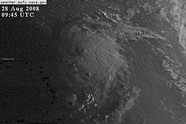
That is what I had mentioned last night,some of the models show this riding right around the periphery of the ULL and then due west into land. The trough will help it move north but will then pull out leaving it behind under the monster ridge that is progged to be there. The models that show fish assume that the trough will pull it out and complete the deal. Apparently they may be wrong and should change in line with NHC soon. If you look at the WV LOOP, you can really see the set up.
0 likes

-
SouthFLTropics

- Category 5
- Posts: 4258
- Age: 50
- Joined: Thu Aug 14, 2003 8:04 am
- Location: Port St. Lucie, Florida
Re: ATL:Tropical Depression Eight in Central Atlantic
A couple of thoughts this morning:
The fact that the Euro has been consistantly pointing at this roller coaster track to South Florida over the past few runs is very concerning...as well as the intensity that it shows...
I hate seeing a forecast track like this...It very much reminds me of a storm in August of 1992 that shall go unnamed here...I don't want to get flamed for comparing future Hanna to the storm that shall remain nameless but it is eerily similar. Not saying that it is going to happen, just similar...
SFT
0 likes

Re: ATL:Tropical Depression Eight in Central Atlantic
Ummm, looks to me that Henna is born...looks like she's sucking in the ULL just east of her as well...a little note for you Fujiwara heads out there 
http://www.ssd.noaa.gov/goes/flt/t2/loop-wv.html
oops, sorry!
http://www.ssd.noaa.gov/goes/flt/t2/loop-wv.html
oops, sorry!
0 likes
Who is online
Users browsing this forum: No registered users and 16 guests