ATL GUSTAV: Tropical Depression - Discussion
Moderator: S2k Moderators
-
sphelps8681
- Category 2

- Posts: 785
- Joined: Thu Aug 16, 2007 5:37 pm
- Location: Somewhere over the rainbow
Re: ATL: Tropical Storm Gustav in Central Caribbean Sea
If it hits Central LA what might we experience if anything in Southeast Texas.
0 likes
-
survived alica
- Tropical Wave

- Posts: 8
- Joined: Mon Aug 04, 2008 3:49 pm
- Location: Houston,Tx
Re: ATL: Tropical Storm Gustav in Central Caribbean Sea
sealbach wrote:NHC shifted the track ever so slightly to the east.
Sealbach, did you use to work for the Ferry in Galveston?
0 likes
-
weatherguru18
Re: ATL: Tropical Storm Gustav in Central Caribbean Sea
sphelps8681 wrote:If it hits Central LA what might we experience if anything in Southeast Texas.
Subsidence. Translation: HOT and DRY
0 likes

Re:
KWT wrote:weatherguru18, problem is thats where a lot of the models are pointing, no where is safe yet I agree but there is growing support for a LA hit and the NHC do suggest something close to N.O
I am not sure I agree with growing support for NO theory. The NHC throws out the cone and splits the difference in the models. In this case, they split the GFDL which has been farthest right and the left GFS....so happens the line (which we should never focus on) is into Central LA.......we are still 4-5 days out....if we are still looking at this same consensus by tomrrow evening / Sat am then I will bite....
0 likes
-
crazycajuncane

- S2K Supporter

- Posts: 1097
- Joined: Sun Aug 15, 2004 2:51 pm
- Location: Lafayette, Louisiana
- Contact:
Re: ATL: Tropical Storm Gustav in Central Caribbean Sea
I said we'd know where this storm is headed with more confidence on Friday, but now it looks like late Saturday afternoon. The good thing is that everyone has basically had another day to prepare. This storm is 24 hours later than projected a day or so ago.
I'm still waiting to see some shifts in the track. The landfall is definitely not good for us in Lafayette at all, but it's too early to worry. If it moves east N.O. is in bad shape. If it moves west well Houston could be in bad shape. It's becoming reality that someone will be seeing some nasty conditions post labor day.
I'm still waiting to see some shifts in the track. The landfall is definitely not good for us in Lafayette at all, but it's too early to worry. If it moves east N.O. is in bad shape. If it moves west well Houston could be in bad shape. It's becoming reality that someone will be seeing some nasty conditions post labor day.
0 likes
-
HouTXmetro

- Category 5

- Posts: 3949
- Joined: Sun Jun 13, 2004 6:00 pm
- Location: District of Columbia, USA
Re: ATL: Tropical Storm Gustav in Central Caribbean Sea
sphelps8681 wrote:If it hits Central LA what might we experience if anything in Southeast Texas.
If it's headed on a WNW heading like the UKMET/HWRF/ or even W/SW Motion after landfall SE Texas could experience at least TS winds should the eye get close enough to the border.
0 likes
-
weatherguru18
Re: ATL: Tropical Storm Gustav in Central Caribbean Sea
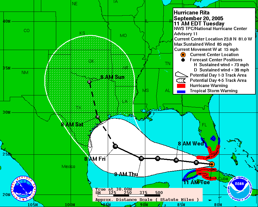
Ok, lets think back to Rita. As Rita was crossing Florida, the official forecast called for a landfall in south Texas with the upper Texas coast not even in the cone. as it continued to chug west, the cone slowly shifted north. Beaumont wasn't even in the cone till several days later. And once it was, it remained on the far eastern fringe of it. Where did Rita hit everybody? Extreme southwestern Louisiana. I think people only focus on the line when its over them.
0 likes
-
Tireman4

- S2K Supporter
- Posts: 5903
- Age: 60
- Joined: Fri Jun 30, 2006 1:08 pm
- Location: Humble, Texas
- Contact:
Re: ATL: Tropical Storm Gustav in Central Caribbean Sea
I agree. Pay attention to the cone. Everyone in the Gulf should pay attention. Even if you are not in the cone. This thing could do anything.
0 likes

-
weatherguru18
Re: ATL: Tropical Storm Gustav in Central Caribbean Sea
crazycajuncane wrote:I said we'd know where this storm is headed with more confidence on Friday, but now it looks like late Saturday afternoon. The good thing is that everyone has basically had another day to prepare. This storm is 24 hours later than projected a day or so ago.
I'm still waiting to see some shifts in the track. The landfall is definitely not good for us in Lafayette at all, but it's too early to worry. If it moves east N.O. is in bad shape. If it moves west well Houston could be in bad shape. It's becoming reality that someone will be seeing some nasty conditions post labor day.
I called my relatives in Sunset and Opeleusous (I have family there and I still can't spell it) and I told them to be ready to leave on Saturday. From what they told me, batteries and water are in short supply there as well.
0 likes

Re: Re:
[quote="ROCK"][quote="KWT"]weatherguru18, problem is thats where a lot of the models are pointing, no where is safe yet I agree but there is growing support for a LA hit and the NHC do suggest something close to N.O[/quote]
I am not sure I agree with growing support for NO theory. The NHC throws out the cone and splits the difference in the models. In this case, they split the GFDL which has been farthest right and the left GFS....so happens the line (which we should never focus on) is into Central LA.......we are still 4-5 days out....if we are still looking at this same consensus by tomrrow evening / Sat am then I will bite....[/quote]
The model consensus has basically been the same for the 3 days...if any shifts occur I do believe they will be west but don't think it'll make it any further west Cameron / Lake Charles unless all the steering currents break down and it stalls for a couple of days...then I think the upper Tx coast to Mid Tx Coast would be under the gun...just MHO
0 likes
-
HouTXmetro
- Category 5
- Posts: 3949
- Joined: Sun Jun 13, 2004 6:00 pm
- Location: District of Columbia, USA
Re: ATL: Tropical Storm Gustav in Central Caribbean Sea
weatherguru18 wrote:crazycajuncane wrote:I said we'd know where this storm is headed with more confidence on Friday, but now it looks like late Saturday afternoon. The good thing is that everyone has basically had another day to prepare. This storm is 24 hours later than projected a day or so ago.
I'm still waiting to see some shifts in the track. The landfall is definitely not good for us in Lafayette at all, but it's too early to worry. If it moves east N.O. is in bad shape. If it moves west well Houston could be in bad shape. It's becoming reality that someone will be seeing some nasty conditions post labor day.
I called my relatives in Sunset and Opeleusous (I have family there and I still can't spell it) and I told them to be ready to leave on Saturday. From what they told me, batteries and water are in short supply there as well.
I have relatives closer to the Coast staring From Laffeyette, Abbeville, New Iberia, Jeanerette and Franklin... Hope they are ready.
0 likes
Re: ATL: Tropical Storm Gustav in Central Caribbean Sea
weatherguru18 wrote:Ok, lets think back to Rita. As Rita was crossing Florida, the official forecast called for a landfall in south Texas with the upper Texas coast not even in the cone. as it continued to chug west, the cone slowly shifted north. Beaumont wasn't even in the cone till several days later. And once it was, it remained on the far eastern fringe of it. Where did Rita hit everybody? Extreme southwestern Louisiana. I think people only focus on the line when its over them.
It might move either way in the next few days...Cajunmama is right.....
0 likes
-
Texas Snowman

- Storm2k Moderator

- Posts: 6197
- Joined: Fri Jan 25, 2008 11:29 am
- Location: Denison, Texas
Re: ATL: Tropical Storm Gustav in Central Caribbean Sea
Very, very interesting blog entry by the Houston Chronicle's SciGuy on average error margin from 5 days out.
Very enlightening read.
http://blogs.chron.com/sciguy/archives/ ... an_we.html
Very enlightening read.
http://blogs.chron.com/sciguy/archives/ ... an_we.html
0 likes
-
weatherguru18
Re: ATL: Tropical Storm Gustav in Central Caribbean Sea
HouTXmetro wrote:weatherguru18 wrote:crazycajuncane wrote:I said we'd know where this storm is headed with more confidence on Friday, but now it looks like late Saturday afternoon. The good thing is that everyone has basically had another day to prepare. This storm is 24 hours later than projected a day or so ago.
I'm still waiting to see some shifts in the track. The landfall is definitely not good for us in Lafayette at all, but it's too early to worry. If it moves east N.O. is in bad shape. If it moves west well Houston could be in bad shape. It's becoming reality that someone will be seeing some nasty conditions post labor day.
I called my relatives in Sunset and Opeleusous (I have family there and I still can't spell it) and I told them to be ready to leave on Saturday. From what they told me, batteries and water are in short supply there as well.
I have relatives closer to the Coast staring From Laffeyette, Abbeville, New Iberia, Jeanerette and Franklin... Hope they are ready.
Oh okay. I'm familiar with most of those areas. God knows I've been there enough. They had a dry run with Lili in 2003. Correct me if I'm wrong, but I don't believe they face the evacuation logistical problems that Houston or New Orleans does.
0 likes

Re: ATL: Tropical Storm Gustav in Central Caribbean Sea
weatherguru18 wrote:Ok, lets think back to Rita. As Rita was crossing Florida, the official forecast called for a landfall in south Texas with the upper Texas coast not even in the cone.
Hmm?
0 likes
-
AL Chili Pepper

- Category 3

- Posts: 873
- Joined: Thu Aug 12, 2004 1:15 pm
- Location: Mobile, AL
Re: ATL: Tropical Storm Gustav in Central Caribbean Sea
sphelps8681 wrote:If it hits Central LA what might we experience if anything in Southeast Texas.
actually probably a beautiful day. I've seen some of the bluest skies on the western side of a hurricane.
0 likes
Re: Re:
N2Storms wrote:ROCK wrote:KWT wrote:weatherguru18, problem is thats where a lot of the models are pointing, no where is safe yet I agree but there is growing support for a LA hit and the NHC do suggest something close to N.O
I am not sure I agree with growing support for NO theory. The NHC throws out the cone and splits the difference in the models. In this case, they split the GFDL which has been farthest right and the left GFS....so happens the line (which we should never focus on) is into Central LA.......we are still 4-5 days out....if we are still looking at this same consensus by tomrrow evening / Sat am then I will bite....
The model consensus has basically been the same for the 3 days...if any shifts occur I do believe they will be west but don't think it'll make it any further west Cameron / Lake Charles unless all the steering currents break down and it stalls for a couple of days...then I think the upper Tx coast to Mid Tx Coast would be under the gun...just MHO
Not exactly 3 days of consensus more like 2 I will give you that.....the 18Z GFDL on Wed had Gus destroying Galveston as a cat 4.....
0 likes
-
Ed Mahmoud
Re: ATL: Tropical Storm Gustav in Central Caribbean Sea
How will a Louisiana landfall affect Texas- in my amateur opininion, from my experiences, it all depends.
When Katrina made landfall on the LA/MS line, an outer rain band actually rotated through the Galleria area. I was watching radar and satellite, and it was one of the outer most bands.
I don't think Gustav will be quite that big when it hits Louisiana, if it is still moving Northwest when it hits, besides the subsidence ahead of it, when it gets closer, we'd have North or Northwest winds, not the best direction for rain.
If Gustav hits further West in Louisiana than the current projection, I'd suspect the BPT area would get some squalls from it. All depends on the strength and size. Humberto made landfall closer to us, to our East, than Rita, and there was no obvious sensible weather really, whereas Rita caused some rain and wind gusts in excess of tropical storm force, judging by tree and fence damage around here.
0 likes
-
hurrican19
- Tropical Storm

- Posts: 153
- Joined: Sun Jun 13, 2004 1:36 pm
- Location: Northwest Austin, TX
Re: ATL: Tropical Storm Gustav in Central Caribbean Sea
Exactly... Everyone seems to just look "at the line".. Remember several years ago the NHC wanted to totally do away w/ the line, but keep everything just as a "Cone" with a dot where they think its going to be? That way, it'd be nearly impossible to try to figure it out.. They gave the public the power to vote for change or not, and we voted to stay the way it was. I personally like the line also, but NEVER follow the line.. the cone is most important this many days out...
Also of importance, to remember, from the NHC 5PM Disco..
IN FACT...TAKING INTO
ACCOUNT THE UNCERTAINTIES IN TRACK...INTENSITY...AND SIZE
FORECASTS...THE CHANCES OF HURRICANE-FORCE WINDS WITHIN THE NEXT
FIVE DAYS ARE ESSENTIALLY THE SAME AT EACH INDIVIDUAL LOCATION FROM
THE FLORIDA PANHANDLE COAST WESTWARD THROUGH THE ENTIRE COASTLINE
OF LOUISIANA.
As mentioned earlier by other members, the ENTIRE Gulf Coast needs to watch out, just because Texas isn't mentioned here does NOT mean we are in the clear.... Remember, the CONE.
0 likes
Who is online
Users browsing this forum: No registered users and 19 guests