

ATL HANNA: Extratropical - Discussion
Moderator: S2k Moderators

Nope circulation still under the convection, I think given the shear looks like its eased down some slow steady strengthening should occur. This is going to be another horrible system to track I suspect and it could just about go anywere past 96hrs when steering currents weaken.
Hurakan, looks like Hanna is a very convective tropcial storm!
Hurakan, looks like Hanna is a very convective tropcial storm!
0 likes
Re: ATL: Tropical Storm Hanna in Western Atlantic
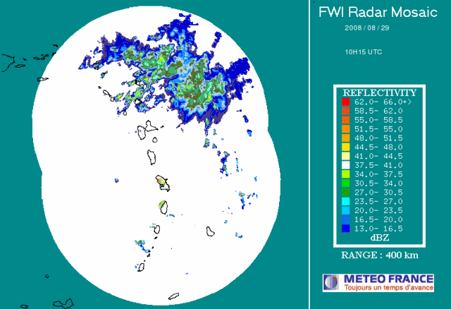
looks poor IMO
where is the low , thunder i don't see it
http://www.ssd.noaa.gov/goes/flt/t2/loop-ir2.html
is that it by 21.3 61.6 or so
http://www.ssd.noaa.gov/goes/flt/t2/loop-avn.html
convection was most impressive last nite se of center (even all the way down south and east of the leeward island (17-19) but that SSE most area of convection is weakening
and the main blob just se of center (around 20/59.5) is still steady
upper level divergence is now excellent but not over the center (to the SSE)
http://cimss.ssec.wisc.edu/tropic/real- ... g8dvg.html
0 likes
Re: ATL: Tropical Storm Hanna in Western Atlantic
also i note a tone of skeptism in the key west discussion and a bit of hmmm regarding gustav track (which would impact the track of hanna)
basically they say gustav may turn more NNW as gustav approaches the caymans in response to the digging trough/mid level florida ridge weakening and they are not sure when the NW/wnw movement (caused by the building bermuda high ridge would re-commence) hmmm
not sure how this effects our girl hanna but if i were in the keys i would be watching gustav "the gulf coast" terror
0 likes
-
jlauderdal
- S2K Supporter

- Posts: 7240
- Joined: Wed May 19, 2004 5:46 am
- Location: NE Fort Lauderdale
- Contact:
Re: ATL: Tropical Storm Hanna in Western Atlantic
cpdaman wrote:also i note a tone of skeptism in the key west discussion and a bit of hmmm regarding gustav track (which would impact the track of hanna)
basically they say gustav may turn more NNW as gustav approaches the caymans in response to the digging trough/mid level florida ridge weakening and they are not sure when the NW/wnw movement (caused by the building bermuda high ridge would re-commence) hmmm
not sure how this effects our girl hanna but if i were in the keys i would be watching gustav "the gulf coast" terror
100 miles to the east of the track makes a big difference for what key west gets so minor track changes e or w really make a difference down there.
0 likes
Re: ATL: Tropical Storm Hanna in Western Atlantic
yes very true jlauderdal
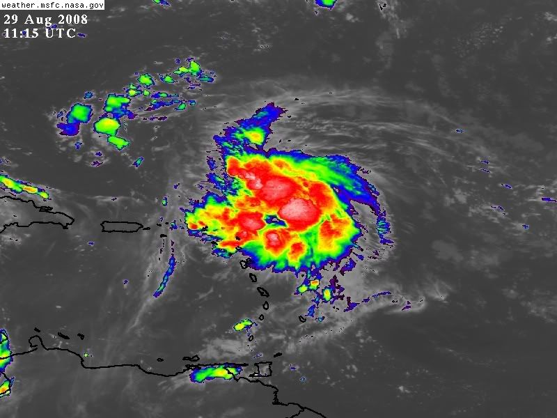
also o town if the center were in the NE portion i would say she looks pretty good
appears the center is on the NW edge (unless she got pulled east under deeper convection last nite)
EDIT my BAD o-town not sure what i was seeing ??? convection appears to be increasing pretty streadily near the center in the last hour.........good call
Last edited by cpdaman on Fri Aug 29, 2008 6:50 am, edited 1 time in total.
0 likes
-
sfwx

- Category 1

- Posts: 371
- Age: 60
- Joined: Thu Sep 04, 2003 1:53 pm
- Location: Rural St. Lucie County, Fl
Re: ATL: Tropical Storm Hanna in Western Atlantic
cpdaman wrote:also i note a tone of skeptism in the key west discussion and a bit of hmmm regarding gustav track (which would impact the track of hanna)
basically they say gustav may turn more NNW as gustav approaches the caymans in response to the digging trough/mid level florida ridge weakening and they are not sure when the NW/wnw movement (caused by the building bermuda high ridge would re-commence) hmmm
not sure how this effects our girl hanna but if i were in the keys i would be watching gustav "the gulf coast" terror
000
FXUS62 KKEY 290701
AFDKEY
AREA FORECAST DISCUSSION FOR THE FLORIDA KEYS
NATIONAL WEATHER SERVICE KEY WEST FL
305 AM EDT FRI AUG 29 2008
.DISCUSSION...
.CURRENTLY...
KBYX DETECTS ISOLATED SHOWERS AND THUNDERSTORMS THROUGHOUT THE
FORECAST AREA. SKIES OVER THE ISLAND CHAIN ARE PARTLY CLOUDY. WINDS
OVER LAND ARE EAST AT 10 TO 15 MPH. C-MAN WINDS...ON AVERAGE...ARE
NORTHEAST TO EAST NEAR 15 KNOTS...WITH GUSTS NEAR 20 KNOTS.
TEMPERATURES ARE IN THE MID 80S. ONLY ABOUT SIX DEGREES OF WARMING
IS EXPECTED TODAY DUE TO MODERATE EAST SURFACE WINDS OVER WATER WITH
TEMPERATURES IN THE UPPER 80S.
.SHORT TERM (TODAY THROUGH SUNDAY)...
TROPICAL STORM GUSTAV WILL MOVE TO THE WEST-NORTHWEST ACROSS THE
NORTHWESTERN CARIBBEAN SEA TODAY...BEFORE TURNING TO THE NORTHWEST
TONIGHT. GUSTAV SHOULD STRENGTHEN INTO A HURRICANE LATER TODAY AS IT
MOVES FROM THE SOUTHERN COAST OF JAMAICA OVER VERY WARM WATER.
GUSTAV SHOULD TRACK TO THE NORTHWEST INTO THE GULF OF MEXICO...
EITHER OVER THE WESTERN TIP OF CUBA OR THROUGH THE YUCATAN
CHANNEL...LATE SATURDAY INTO SATURDAY NIGHT. GUSTAV SHOULD BEGIN
PULLING AWAY FROM THE FORECAST AREA SUNDAY. GUSTAV SHOULD PASS CLOSE
ENOUGH TO THE FLORIDA KEYS TO PRODUCE WINDY CONDITIONS AND WELL
ABOVE NORMAL RAIN CHANCES SATURDAY THROUGH AT LEAST SUNDAY MORNING.
WINDS AND RAIN CHANCES SHOULD DECREASE SUNDAY AFTERNOON AS GUSTAV
PULLS AWAY FROM THE SERVICE AREA.
GIVEN THE CURRENT FORECAST TRACK OF TROPICAL CYCLONE GUSTAV...KEYS
EMERGENCY MANAGEMENT OFFICIALS DO NOT ANTICIPATE THE NEED FOR
PROTECTIVE ACTIONS.
.LONG TERM (SUNDAY NIGHT THROUGH THURSDAY)...
ABOVE NORMAL RAIN CHANCES WILL BE MAINTAINED FOR SUNDAY NIGHT
THROUGH THURSDAY AS THE CLIMATOLOGICAL PEAK OF THE RAINY SEASON
APPROACHES IN EARLY SEPTEMBER. TROPICAL STORM HANNA MAY AFFECT THE
FLORIDA KEYS WEDNESDAY AND THURSDAY. FORECAST UNCERTAINTY IS VERY
HIGH REGARDING TROPICAL STORM HANNA...SO NO CHANGES WILL BE MADE TO
THE WEDNESDAY AND THURSDAY PORTION OF THE ZONE FORECASTS FOR THE
FLORIDA KEYS AT THIS TIME.
&&
.MARINE...
SMALL CRAFT SHOULD EXERCISE CAUTION ON ATLANTIC WATERS TODAY DUE TO
SUSTAINED EAST SURFACE WINDS OF 15 TO 20 KNOTS. SMALL CRAFT SHOULD
EXERCISE CAUTION ON GULF AND FLORIDA BAY WATERS TONIGHT DUE TO
SUSTAINED EAST SURFACE WINDS OF 15 TO 20 KNOTS. A SMALL CRAFT
ADVISORY MAY BE REQUIRED FOR ATLANTIC WATERS TONIGHT. A SMALL CRAFT
ADVISORY WILL LIKELY BE REQUIRED FOR ALL KEYS WATERS SATURDAY
THROUGH AT LEAST SUNDAY MORNING. WINDS SHOULD DECREASE SUNDAY
AFTERNOON AND SUNDAY NIGHT AS TROPICAL CYCLONE GUSTAV PULLS AWAY
FROM THE FORECAST AREA. NO ADVISORIES OR CAUTIONARY STATEMENTS
EXPECTED MONDAY AND TUESDAY.
&&
.AVIATION...
TODAY...PRESSURE GRADIENT WILL INCREASE IN RESPONSE TO COMPLEX FLOW
PATTERN. THROUGH 15Z...ISOLATED SHOWERS AND THUNDERSTORMS WILL
IMPACT THE KEYW AND KMTH ISLAND TERMINALS. SUSTAINED WINDS FROM
BETWEEN 050 AND 080 DEGREES @ 10 TO 12 KNOTS WITH GUSTS TO NEAR 20
KNOTS WILL INCREASE DURING THE LATE MORNING HOURS TO BETWEEN 12 AND
15 KNOTS WITH GUSTS BETWEEN 18 AND 25 KNOTS. SHOWER COVERAGE WILL
INCREASE SLIGHTLY BY AFTERNOON...WITH SCATTERED SHOWERS AND ISOLATED
THUNDERSTORMS EXPECTED TO IMPACT THE TERMINALS. THESE SHOWERS WILL
OCCUR WITH MORE FREQUENCY...SO VICINITY SHOWERS WILL BE ADDED TO THE
TAFS. BRIEF MVFR/IFR CIGS AND OR VIS WILL BE LIKELY WITHIN ANY
SHOWERS OR THUNDERSTORMS...WITH ISOLATED WIND GUSTS BETWEEN 25 AND
35 KNOTS POSSIBLE IN THE HEAVIEST SHOWERS AND STORMS.
&&
.CLIMATE...
ON THIS DATE IN KEYS WEATHER HISTORY...IN 1881...THE HIGH
TEMPERATURE IN KEY WEST WAS 95 DEGREES. THIS SET THE DAILY RECORD
FOR MAXIMUM TEMPERATURE MEASURED IN KEY WEST ON AUGUST 29TH...A
RECORD WHICH STILL STANDS 127 YEARS LATER.
&&
.PRELIMINARY POINT TEMPS/POPS...
KEY WEST 90 81 89 80 / 30 30 40 50
MARATHON 91 82 90 81 / 30 30 40 50
&&
.KEY WATCHES/WARNINGS/ADVISORIES...
FL...NONE.
GM...NONE.
&&
$$
PUBLIC/MARINE/FIRE/CLIMATE/DIGITAL...BS
AVIATION/NOWCASTS....................DAF
VISIT US ON THE WEB AT http://WWW.WEATHER.GOV/KEYWEST
0 likes
-
HURRICANELONNY
- Category 5

- Posts: 1390
- Joined: Wed May 07, 2003 6:48 am
- Location: HOLLYWOOD.FL
Re: ATL: Tropical Storm Hanna in Western Atlantic
Looks like this morning the shear is still there from the ULL. Suppose to get out of the way according to the globals. As for the future track and intensity. Who knows. Right now the center appears west of all the convection. If it can survive the first wave of shear. Then the second wave from the High that will develop on the east coast. Will also cause northerly shear. I think depending on Hanna's strength. Will know how it will react to the northerly shear by next week. All I'm doing is keeping an eye on Hanna this weekend. No preps for me. Too far out. 
0 likes
Re: ATL: Tropical Storm Hanna in Western Atlantic
for clarification sfwx
there continued use of the word "should" (PRIOR) to and combined with the latest NHC discussion on gustav
ONE BIG QUESTION IS THE EVOLUTION OF A MID- TO UPPER-
LEVEL LOW OVER THE SOUTHEASTERN UNITED STATES. SOME OF THE
MODELS...SUCH AS THE GFS/GFDL/HWRF...ARE SHOWING THIS LOW CREATING
ENOUGH OF A WEAKNESS IN THE BERMUDA HIGH TO ALLOW A MOTION MORE
TOWARD THE NORTH-NORTHWEST AS THE SYSTEM CROSSES CUBA
....BUT IN THE
LONGER-TERM...A HIGH OVER THE OHIO VALLEY IS EXPECTED TO CAUSE
GUSTAV TO GRADUALLY BEND TO THE LEFT. HOWEVER...THERE IS A LARGE
UNCERTAINTY IN THE TIMING AND SHARPNESS OF THE BEND
Last edited by cpdaman on Fri Aug 29, 2008 6:54 am, edited 1 time in total.
0 likes
-
Evil Jeremy

- S2K Supporter
- Posts: 5463
- Age: 32
- Joined: Mon Apr 10, 2006 2:10 pm
- Location: Los Angeles, CA
-
sfwx
- Category 1
- Posts: 371
- Age: 60
- Joined: Thu Sep 04, 2003 1:53 pm
- Location: Rural St. Lucie County, Fl
Re: ATL: Tropical Storm Hanna in Western Atlantic
cpdaman wrote:for clarification sfwx
there continued use of the word "should" (PRIOR) to and combined with the latest NHC discussion on gustav
ONE BIG QUESTION IS THE EVOLUTION OF A MID- TO UPPER-
LEVEL LOW OVER THE SOUTHEASTERN UNITED STATES. SOME OF THE
MODELS...SUCH AS THE GFS/GFDL/HWRF...ARE SHOWING THIS LOW CREATING
ENOUGH OF A WEAKNESS IN THE BERMUDA HIGH TO ALLOW A MOTION MORE
TOWARD THE NORTH-NORTHWEST AS THE SYSTEM CROSSES CUBA
....BUT IN THE
LONGER-TERM...A HIGH OVER THE OHIO VALLEY IS EXPECTED TO CAUSE
GUSTAV TO GRADUALLY BEND TO THE LEFT. HOWEVER...THERE IS A LARGE
UNCERTAINTY IN THE TIMING AND SHARPNESS OF THE BEND
Interesting. Thanks for the clarification.
Miami's AFD this morning said this of Hanna:
THE FORECAST FOR THE MIDDLE TO END OF NEXT WEEK WILL ALL DEPEND ON
THE TRACK OF TROPICAL STORM HANNA WHICH IS LOCATED NORTHEAST OF
THE LEEWARD ISLANDS EARLY THIS MORNING. THE NATIONAL HURRICANE
CENTER`S TRACK TAKES HANNA NORTHWEST INTO THE WESTERN ATLANTIC
WATERS BY MIDDLE OF NEXT WEEK. THE LONG RANGE 18Z GFS MODEL THEN
MOVES HER SLOWLY TOWARDS CENTRAL FLORIDA BY LATE NEXT WEEK...AS
THE ECWMF MODEL MOVES HER SOUTHWEST INTO THE FLORIDA STRAITS. AT
THIS TIME WILL LEAN TOWARDS THE GFS MODEL RUN WHICH WILL PUT SOUTH
FLORIDA IN A SOUTH TO SOUTHWEST WIND DIRECTION BY THE MIDDLE TO
END OF NEXT WEEK...WITH THE HIGHEST POPS OVER THE INTERIOR AND
EAST COAST AREAS.
0 likes
-
gatorcane

- S2K Supporter
- Posts: 23708
- Age: 48
- Joined: Sun Mar 13, 2005 3:54 pm
- Location: Boca Raton, FL
Re:
Evil Jeremy wrote:Here in SFL, I am on the edge of my seat. There is alot of uncertainty on where this will end up, and if it does come our way, it could be huge.
No need to be on the edge of your seat -- Florida is about 7-8 days out from a hit and alot can change especially 5+ days out.
0 likes
-
sfwx
- Category 1
- Posts: 371
- Age: 60
- Joined: Thu Sep 04, 2003 1:53 pm
- Location: Rural St. Lucie County, Fl
Re: ATL: Tropical Storm Hanna in Western Atlantic
Maybe some good news regarding Hanna from the Melbourne AFD:
TUE-FRI...FCST REMAINS VERY UNCERTAIN AND HIGHLY DEPENDENT UPON THE
TRACK AND STRENGTH OF HANNA. ONE TREND NOTED ON THE MORE RELIABLE
GLOBAL MODEL GUIDANCE IS THAT THE UPPER LEVEL PATTERN BECOMES QUITE
HOSTILE FROM LATE MONDAY ONWARD OVER THE WESTERN SARGASSO SEA AREA
...WHERE HANNA IS FCST TO BE..AS A 40-50KT NNW-N JET IS FCST TO
DEVELOP ON THE EAST SIDE OF THE ERN CONUS DLM RIDGE. THIS IS
REFLECTED IN SIGNIFICANT SLOWING IN FWD SPEED ALONG WITH A TURN TWD
THE SW...AND A REVERSAL OF THE INTENSIFICATION TREND...BY MON-TUE.
WE WILL CONTINUE TO WATCH THE PROGRESS OF HANNA CLOSELY HERE ALONG
THE EAST COAST OF FL.
REGARDLESS...SFC HIGH PRES TO THE NORTH SHOULD PRODUCE RATHER BRISK
ONSHORE FLOW THRU MUCH OF THE XTD RANGE...WHICH WOULD CONTINUE THE
REGIME OF NIGHTTIME/MORNING SHRA AND SCT AFTN SHRA WITH LIMITED
COVERAGE OF TS. COVERAGE COULD WIND UP UNUSUALLY LOW FOR AUGUST
SHOULD MEAN LYR DRYING BE STRONGER THAN WHAT GUIDANCE IS INDICATING.
ON THE OTHER HAND...WITH A T.C. EAST OF THE BAHAMAS...CONFIDENCE IN
ANY SCENARIO RIGHT NOW IS PRETTY LOW.
0 likes

Re: ATL: Tropical Storm Hanna in Western Atlantic
sfwx wrote:cpdaman wrote:for clarification sfwx
there continued use of the word "should" (PRIOR) to and combined with the latest NHC discussion on gustav
ONE BIG QUESTION IS THE EVOLUTION OF A MID- TO UPPER-
LEVEL LOW OVER THE SOUTHEASTERN UNITED STATES. SOME OF THE
MODELS...SUCH AS THE GFS/GFDL/HWRF...ARE SHOWING THIS LOW CREATING
ENOUGH OF A WEAKNESS IN THE BERMUDA HIGH TO ALLOW A MOTION MORE
TOWARD THE NORTH-NORTHWEST AS THE SYSTEM CROSSES CUBA
....BUT IN THE
LONGER-TERM...A HIGH OVER THE OHIO VALLEY IS EXPECTED TO CAUSE
GUSTAV TO GRADUALLY BEND TO THE LEFT. HOWEVER...THERE IS A LARGE
UNCERTAINTY IN THE TIMING AND SHARPNESS OF THE BEND
Interesting. Thanks for the clarification.
Miami's AFD this morning said this of Hanna:
THE FORECAST FOR THE MIDDLE TO END OF NEXT WEEK WILL ALL DEPEND ON
THE TRACK OF TROPICAL STORM HANNA WHICH IS LOCATED NORTHEAST OF
THE LEEWARD ISLANDS EARLY THIS MORNING. THE NATIONAL HURRICANE
CENTER`S TRACK TAKES HANNA NORTHWEST INTO THE WESTERN ATLANTIC
WATERS BY MIDDLE OF NEXT WEEK. THE LONG RANGE 18Z GFS MODEL THEN
MOVES HER SLOWLY TOWARDS CENTRAL FLORIDA BY LATE NEXT WEEK...AS
THE ECWMF MODEL MOVES HER SOUTHWEST INTO THE FLORIDA STRAITS. AT
THIS TIME WILL LEAN TOWARDS THE GFS MODEL RUN WHICH WILL PUT SOUTH
FLORIDA IN A SOUTH TO SOUTHWEST WIND DIRECTION BY THE MIDDLE TO
END OF NEXT WEEK...WITH THE HIGHEST POPS OVER THE INTERIOR AND
EAST COAST AREAS.
I guess they missed the 00z and 6z GFS runs this am
0 likes
-
AJC3

- Admin

- Posts: 4153
- Age: 62
- Joined: Tue Aug 31, 2004 7:04 pm
- Location: Ballston Spa, New York
- Contact:
Re: ATL: Tropical Storm Hanna in Western Atlantic
sfwx wrote: Miami's AFD this morning said this of Hanna:
THE FORECAST FOR THE MIDDLE TO END OF NEXT WEEK WILL ALL DEPEND ON
THE TRACK OF TROPICAL STORM HANNA WHICH IS LOCATED NORTHEAST OF
THE LEEWARD ISLANDS EARLY THIS MORNING. THE NATIONAL HURRICANE
CENTER`S TRACK TAKES HANNA NORTHWEST INTO THE WESTERN ATLANTIC
WATERS BY MIDDLE OF NEXT WEEK. THE LONG RANGE 18Z GFS MODEL THEN
MOVES HER SLOWLY TOWARDS CENTRAL FLORIDA BY LATE NEXT WEEK...AS
THE ECWMF MODEL MOVES HER SOUTHWEST INTO THE FLORIDA STRAITS. AT
THIS TIME WILL LEAN TOWARDS THE GFS MODEL RUN WHICH WILL PUT SOUTH
FLORIDA IN A SOUTH TO SOUTHWEST WIND DIRECTION BY THE MIDDLE TO
END OF NEXT WEEK...WITH THE HIGHEST POPS OVER THE INTERIOR AND
EAST COAST AREAS.
This is a real head scratcher.
Why would you want to talk about the 18Z GFS, when 1) it's an intermediate and, more importantly, a notoriously poor model run, and 2) The more recent, and more reliable 00Z run had been out for hours.
2) S-SW wind flow? I don't think there is one single model that shows S-SW wind flow across south Florida next week. Not the GFS...not anything.
Last edited by AJC3 on Fri Aug 29, 2008 7:14 am, edited 1 time in total.
0 likes
-
DESTRUCTION5

- Category 5
- Posts: 4430
- Age: 44
- Joined: Wed Sep 03, 2003 11:25 am
- Location: Stuart, FL
Here is some good news from JB..
"But make no mistake about it, this is history in the making. Hanna, as suspected, will not only be caught and not only does it go to Florida, but such storms as Andrew, Betsy, Katrina, come to mind that came back west from east of 70 and scored double hits. "
"But make no mistake about it, this is history in the making. Hanna, as suspected, will not only be caught and not only does it go to Florida, but such storms as Andrew, Betsy, Katrina, come to mind that came back west from east of 70 and scored double hits. "
0 likes
-
gatorcane
- S2K Supporter
- Posts: 23708
- Age: 48
- Joined: Sun Mar 13, 2005 3:54 pm
- Location: Boca Raton, FL
Re:
DESTRUCTION5 wrote:Here is some good news from JB..
"But make no mistake about it, this is history in the making. Hanna, as suspected, will not only be caught and not only does it go to Florida, but such storms as Andrew, Betsy, Katrina, come to mind that came back west from east of 70 and scored double hits. "
I read that a few times, is that really good news?
0 likes
-
AJC3
- Admin
- Posts: 4153
- Age: 62
- Joined: Tue Aug 31, 2004 7:04 pm
- Location: Ballston Spa, New York
- Contact:
Re:
DESTRUCTION5 wrote:Here is some good news from JB..
"But make no mistake about it, this is history in the making. Hanna, as suspected, will not only be caught and not only does it go to Florida, but such storms as Andrew, Betsy, Katrina, come to mind that came back west from east of 70 and scored double hits. "
Good lord...will he still be bringing up the gloom and doom comparisons if and when Hanna starts getting pelted by 40-50kt of NNW shear east of the Bahamas?
0 likes
-
DESTRUCTION5
- Category 5
- Posts: 4430
- Age: 44
- Joined: Wed Sep 03, 2003 11:25 am
- Location: Stuart, FL
Re: Re:
gatorcane wrote:DESTRUCTION5 wrote:Here is some good news from JB..
"But make no mistake about it, this is history in the making. Hanna, as suspected, will not only be caught and not only does it go to Florida, but such storms as Andrew, Betsy, Katrina, come to mind that came back west from east of 70 and scored double hits. "
I read that a few times, is that really good news?
Sarcastic Gator..
0 likes
Who is online
Users browsing this forum: No registered users and 39 guests