sanibel, i agree. a more rightward track even in the short term would move track. if it gets closer to nola, i feel west turn will be further inland. further west and it could be inland, but closer to the coast.
has anybody heard if they are cancelling lsu game, i would.
ATL GUSTAV: Tropical Depression - Discussion
Moderator: S2k Moderators
-
Matt-hurricanewatcher
Re: Cat. 3 Hurricane Gustav in NW Caribbean Sea
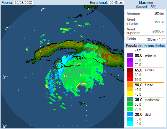
Looks like it has buttomed out for the moment, based on recon and satellite. You can see that the reds no longer go all the way around, but have some orange and yellows on the southeast side.
0 likes
Re: Cat. 3 Hurricane Gustav in NW Caribbean Sea
Of course if Gus gets east of N.O. and hooks a west turn right into N.O. from the SE that wouldn't be good.
These are classic intensification wobbles in the eye structure. Gus has been doing them since it left Jamaica. The fist never lies.
These are classic intensification wobbles in the eye structure. Gus has been doing them since it left Jamaica. The fist never lies.
0 likes


-
Sabanic

- Category 2

- Posts: 683
- Age: 66
- Joined: Wed Aug 01, 2007 7:01 am
- Location: Mobile, AL
- Contact:
Re: Cat. 3 Hurricane Gustav in NW Caribbean Sea
Looks like we'll be spared on this one, but we'll definitely be praying for those to our West. Seems the high is going to be far too strong for Gus to push his way eastward towards us. At least at this time.
0 likes

Re: Cat. 3 Hurricane Gustav in NW Caribbean Sea
I've just zoomed in on Cayo Largo, south of Cuba, on Google Earth and I don't think I've seen anywhere that's so picture postcard perfect. Gustav seems to be heading straight for there and if that happens, I would think the coral reefs there will be absolutely churned up - it also seems to be a busy holiday resort so I hope they've got everyone out.
Looks like Cuba may have a Cat 4 approaching them soon. I hope there's no loss of life and everyone gets out of harm's way.
I would think that New Orleans may recommend evacuation soon. Hope the repairs done so far will protect the city and everyone gets out safely this time.
Looks like Cuba may have a Cat 4 approaching them soon. I hope there's no loss of life and everyone gets out of harm's way.
I would think that New Orleans may recommend evacuation soon. Hope the repairs done so far will protect the city and everyone gets out safely this time.
0 likes

Re:
dwg71 wrote:tampa its hard to argue with that. nhc has it going south of isle of youth. if current heading of the past couple of hours continues it will miss it north. have to wait to see how large if any, a deviation it is.
I just noticed that. It looks like it will travel at least on the north half of the isle of youth. It might not affect the 3-day track (might just be a wobble), but if it keeps that heading for a day or so then the track is greatly affected.
Keep in mind that the 3-day track for Katrina had forecast a landfall in Destin - PCB area for a good day or so. I'm not saying this to disprove the NHC track, but to make people aware that the track can still shift 150+ miles in either direction.
0 likes
Re: Cat. 3 Hurricane Gustav in NW Caribbean Sea
Watch for slight eastward adjustment of track.
Back to bed.
Back to bed.
0 likes
Re: Cat. 3 Hurricane Gustav in NW Caribbean Sea
Sanibel wrote:Watch for slight eastward adjustment of track.
Back to bed.
I agree...... probably about 15-20 miles (at landfall).
0 likes
Re: Re:
TideJoe wrote:dwg71 wrote:tampa its hard to argue with that. nhc has it going south of isle of youth. if current heading of the past couple of hours continues it will miss it north. have to wait to see how large if any, a deviation it is.
I just noticed that. It looks like it will travel at least on the north half of the isle of youth. It might not affect the 3-day track (might just be a wobble), but if it keeps that heading for a day or so then the track is greatly affected.
Keep in mind that the 3-day track for Katrina had forecast a landfall in Destin - PCB area for a good day or so. I'm not saying this to disprove the NHC track, but to make people aware that the track can still shift 150+ miles in either direction.
i agree that it could still change, that recurve forecast was stricky with katrina. if current heading keeps up for a couple more hours, i like sani expect shift slightly east and quicker landfall.
0 likes
-
Weatherfreak000
-
HouTXmetro

- Category 5

- Posts: 3949
- Joined: Sun Jun 13, 2004 6:00 pm
- Location: District of Columbia, USA


Re:
Weatherfreak000 wrote:It's without question slightly North and East of the forecast points...
Landfall interaction will be CRUCIAL to determine final landfall.
Sat. Pics loop also shows that it is just North & east of track - just click on Trop Fst Points
http://www.ssd.noaa.gov/goes/flt/t1/loop-vis.html
0 likes

>>Watch for slight eastward adjustment of track.
Looking at the SWMFD plot of the 06 and 00z models and with one or two exceptions, I'm smoked out down here in Lafourche Parish. Really, really, really don't need a second disaster in 3 years.
NHC Track takes it about 40 minutes (drivetime) west of here to just SW of Patterson/Bayou Vista/Morgan City/Berwick and the Atachafalaya/East Cote Blanche Bays.
Steve
Looking at the SWMFD plot of the 06 and 00z models and with one or two exceptions, I'm smoked out down here in Lafourche Parish.
NHC Track takes it about 40 minutes (drivetime) west of here to just SW of Patterson/Bayou Vista/Morgan City/Berwick and the Atachafalaya/East Cote Blanche Bays.
Steve
0 likes
Re:
Weatherfreak000 wrote:It's without question slightly North and East of the forecast points...
Landfall interaction will be CRUCIAL to determine final landfall.
And north and east of the forecast doesn't bode well for NO. They need this storm to be as far west of them as they can get it (far east would be even better).
0 likes

-
Portastorm

- Storm2k Moderator

- Posts: 9955
- Age: 63
- Joined: Fri Jul 11, 2003 9:16 am
- Location: Round Rock, TX
- Contact:
Re:
Steve wrote:>>Watch for slight eastward adjustment of track.
Looking at the SWMFD plot of the 06 and 00z models and with one or two exceptions, I'm smoked out down here in Lafourche Parish.
NHC Track takes it about 40 minutes (drivetime) west of here to just SW of Patterson/Bayou Vista/Morgan City/Berwick and the Atachafalaya/East Cote Blanche Bays.
Steve
Um Steve, shouldn't you be "getting out of Dodge" soon?
0 likes
Who is online
Users browsing this forum: No registered users and 12 guests