
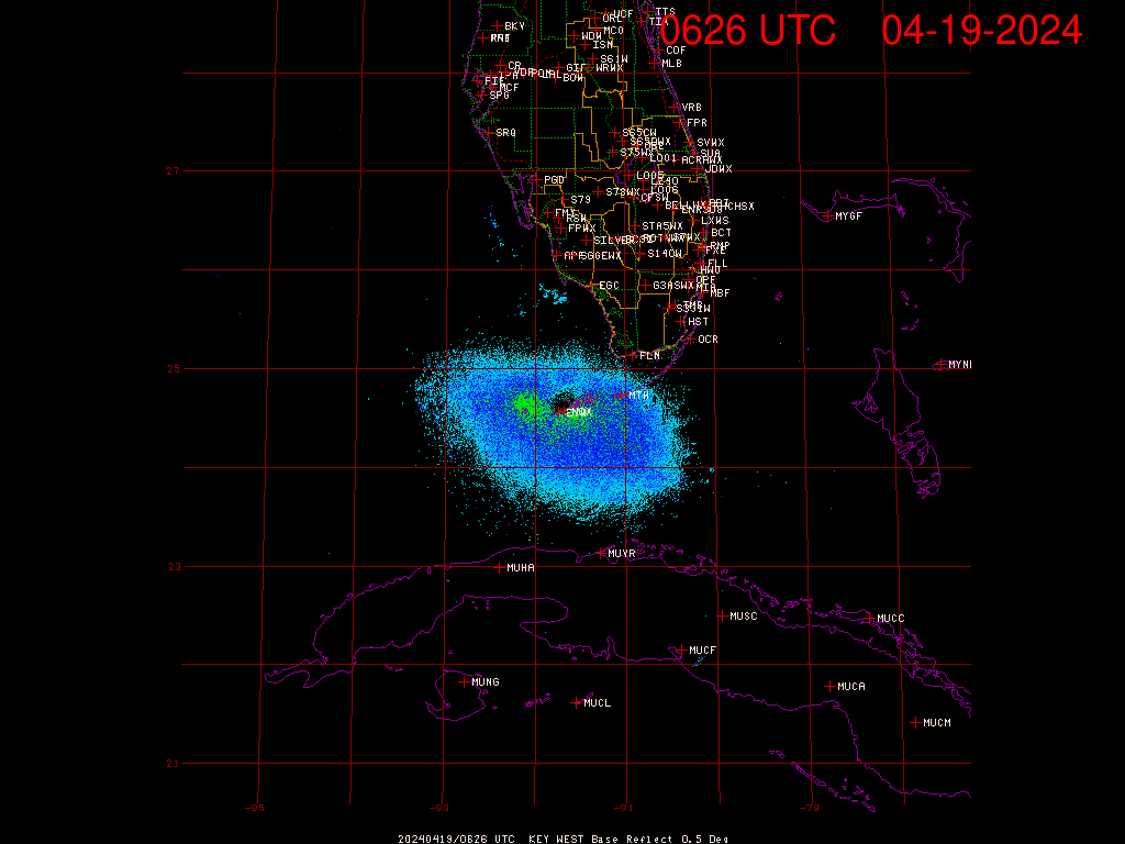
There's the proof for everyone to see...that DEFINITELY is not NW movement and its been doing that for a good while.
ATL GUSTAV: Tropical Depression - Discussion
Moderator: S2k Moderators
-
Weatherfreak000
Re: Cat. 3 Hurricane Gustav in NW Caribbean Sea
There's the proof for everyone to see...that DEFINITELY is not NW movement and its been doing that for a good while.
0 likes

Re: Cat. 3 Hurricane Gustav in NW Caribbean Sea
ronjon wrote:Wow, Gus has really grown in size the last 24 hrs. I was thinking earlier that Gus would be a rather small storm - wrong again. On the N-NW movement, there were a few models (GFS, CMC, NOGAPs) showing that this movement might occur up into the SE GOM a couple of days ago and then it would bend more NW once into the central GOM. Have to wait to see if this is a trend or simply short term wobble.
Agree RonJon - check out SFWMD Radar loop from Key West with forecast tracl overlay - definitly north & east of track.
http://my.sfwmd.gov/sfwmd/common/images/weather/noaaport/radar_byx2_anim.gif
Robert
0 likes
-
soonertwister
- Category 5

- Posts: 1091
- Joined: Mon Jun 16, 2003 2:52 pm
Re: Re:
Chacor wrote:soonertwister wrote:dwg71 wrote:from 4 am to 7am cst, the nhc moved from 20.2 81.3 to 20.8 81.6. That is a huge difference.
By my calculations that was a move of 44 statute miles at a bearing of 298, or roughly 14.7 mph at just north of WNW.
20.2N 81.3W to 20.8N 81.6W is more like 334° at about 15.4 mph by my calculations.
You calculations are wrong. A movemnt of 0.3 degrees west by 0.6 degrees north is motion of 18 nautical miles west and 33.72 north at 20.5 degrees average latitude. That translates to roughly 44 statute miles at 298 degrees.
0 likes
-
HarlequinBoy

- Category 5
- Posts: 1400
- Age: 35
- Joined: Wed Nov 29, 2006 1:57 am
- Location: Memphis

Re: Cat. 3 Hurricane Gustav in NW Caribbean Sea
Bluefrog wrote:Bluefrog wrote:where can we find a map with storm surge potential for Louisiana and Mississippi????
surge map links please ...
http://blog.wired.com/wiredscience/2008/08/maps-storm-surg.html
0 likes
Re:
HarlequinBoy wrote:How much will Cuba disrupt him? I think Charley crossed near that same area and only weakened a bit.
rather little, I think. It's going to go over one of the narrowest parts of the island, so interaction will be rather short lived.
0 likes

Re: Re:
soonertwister wrote:Chacor wrote:20.2N 81.3W to 20.8N 81.6W is more like 334° at about 15.4 mph by my calculations.
You calculations are wrong. A movemnt of 0.3 degrees west by 0.6 degrees north is motion of 18 nautical miles west and 33.72 north at 20.5 degrees average latitude. That translates to roughly 44 statute miles at 298 degrees.
http://www.movable-type.co.uk/scripts/latlong.html
Mathematical scripts don't lie.
Last edited by Chacor on Sat Aug 30, 2008 7:47 am, edited 1 time in total.
0 likes
-
TTheriot1975
- Tropical Storm

- Posts: 113
- Age: 51
- Joined: Thu Aug 16, 2007 8:12 pm
- Location: Southeast Texas
GUSTAV HAS JOGGED TOWARD THE NORTH-NORTHWEST DURING THE PAST FEW
HOURS...BUT IS EXPECTED TO SOON RESUME A MOTION TOWARD THE
NORTHWEST NEAR 12 MPH...19 KM/HR...AND THIS MOTION IS EXPECTED TO
CONTINUE FOR THE NEXT COUPLE OF DAYS. ON THIS TRACK...THE CENTER
OF GUSTAV WILL PASS OVER WESTERN CUBA LATER TODAY AND TONIGHT...AND
MOVE INTO THE SOUTHERN GULF OF MEXICO EARLY SUNDAY AND INTO THE
CENTRAL GULF BY EARLY MONDAY.
0 likes


Re: Cat. 3 Hurricane Gustav in NW Caribbean Sea
948.2 mb reported by the NOAA airplane with 132 flight level winds
0 likes
-
LSU2001

- S2K Supporter

- Posts: 1711
- Age: 58
- Joined: Sat Sep 11, 2004 11:01 pm
- Location: Cut Off, Louisiana
Re: Cat. 3 Hurricane Gustav in NW Caribbean Sea
OK,
Gus is stair stepping,
Back to Gus and potential strengthing and convection wrapping and weakening potential over Cuba.
Tim
Gus is stair stepping,
Back to Gus and potential strengthing and convection wrapping and weakening potential over Cuba.
Tim
0 likes
Re: Cat. 3 Hurricane Gustav in NW Caribbean Sea
good morning, seems gustav gained some strength in the wee hours
appears to me NOW to be more NW (after a quik burst of NNW) and i remember wxman57 saying it may go right of the track in the short term but then bend back left and that pretty much evens itself out (last nite). we shall see
appears to me NOW to be more NW (after a quik burst of NNW) and i remember wxman57 saying it may go right of the track in the short term but then bend back left and that pretty much evens itself out (last nite). we shall see
0 likes
-
soonertwister
- Category 5
- Posts: 1091
- Joined: Mon Jun 16, 2003 2:52 pm
Re: Cat. 3 Hurricane Gustav in NW Caribbean Sea
I have egg on my face! I've done rectangular/polar conversions most of my life, and I still got this one wrong. I should have added 61.9 degrees to 270, not subtracted from 360. So the actual bearing is roughly 332 degrees, or just west of NNW. My mistake.
0 likes
-
karenfromheaven

- Tropical Storm
- Posts: 171
- Age: 71
- Joined: Thu Sep 09, 2004 4:45 pm
- Location: North Naples, FL
Re: Cat. 3 Hurricane Gustav in NW Caribbean Sea
Bluefrog wrote:Bluefrog wrote:where can we find a map with storm surge potential for Louisiana and Mississippi????
surge map links please ...
Hey Bluefrog, NWS has a great experimental web site that plots storm surge probabilities tied to the latest NHC forecast. This is from their product description page (http://www.weather.gov/mdl/psurge/pdd-4.php):
4. Availability
Whenever a hurricane watch or warning is in effect for any portion of the Gulf or Atlantic coasts of the continental United States, the experimental product is available on the Internet at: http://www.weather.gov/mdl/psurge. Updates to the product are produced one hour after the issuance of routine NHC tropical cyclone advisories at 0300, 0900, 1500, and 2100 Coordinated Universal Time (UTC). In addition to the .png images created on the website, the actual data is accessible for download in GRIB2 format. Please note that due to the experimental status of the product, routine and timely dissemination will not be guaranteed.
I just checked, and at the moment they have no data because no watches have been issued yet. Bummer I know, because now is when we would like to be seeing some estimates...
Karen
0 likes
-
JtSmarts

- S2K Supporter
- Posts: 1442
- Age: 40
- Joined: Thu Jul 10, 2003 1:29 pm
- Location: Columbia, South Carolina
Re: Cat. 3 Hurricane Gustav in NW Caribbean Sea
vaffie wrote:948.2 mb reported by the NOAA airplane with 132 flight level winds
If that's true we are real close to Cat 4.
0 likes

Re: Cat. 3 Hurricane Gustav in NW Caribbean Sea
cpdaman wrote:good morning, seems gustav gained some strength in the wee hours
appears to me NOW to be more NW (after a quik burst of NNW) and i remember wxman57 saying it may go right of the track in the short term but then bend back left and that pretty much evens itself out (last nite). we shall see
IIRC, wx57's comments pertained to after the storm left Cuba, BUT, these things do stairstep and even out in the long term direction.
0 likes
-
soonertwister
- Category 5
- Posts: 1091
- Joined: Mon Jun 16, 2003 2:52 pm
Re: Re:
Chacor wrote:soonertwister wrote:Chacor wrote:20.2N 81.3W to 20.8N 81.6W is more like 334° at about 15.4 mph by my calculations.
You calculations are wrong. A movemnt of 0.3 degrees west by 0.6 degrees north is motion of 18 nautical miles west and 33.72 north at 20.5 degrees average latitude. That translates to roughly 44 statute miles at 298 degrees.
http://www.movable-type.co.uk/scripts/latlong.html
Mathematical scripts don't lie.
Pretty correct for bearing, but overestimated on speed.
0 likes

>>Anybody?
Sometimes that would be the case as stronger storms are influenced by different steering levels in the atmosphere. However, like you said, with a giant high progged to sit north of it (one that shows up on surface and upper charts), it's not going to just bust through the high. Rough rule that follows in the deep tropics (think of the stronger storms out in the far Atlantic that recurve into weaknesses) and sometimes in the subtropics, but not always. Hope that helped Mike.
Steve
0 likes
Re: Cat. 3 Hurricane Gustav in NW Caribbean Sea
JtSmarts wrote:vaffie wrote:948.2 mb reported by the NOAA airplane with 132 flight level winds
If that's true we are real close to Cat 4.
Yes, it has the pressure of a strong 3 or weak 4. The winds are catching up.
0 likes

Who is online
Users browsing this forum: No registered users and 18 guests