ATL GUSTAV: Tropical Depression - Discussion
Moderator: S2k Moderators
-
CYCLONE MIKE
- Category 5

- Posts: 2183
- Joined: Tue Aug 31, 2004 6:04 pm
- Location: Gonzales, LA
Appreciate it. Hey Steve where do you live down in LaFourche? You gettin out of there? You think the western edge of the high erodes enough to turn Gustav a little more to the east before the high in the plains builds in? I am thinking landfall around Grand Isle? For some reason, don't know why that is the area I am most concerned about. Just between N.O. and Grand Isle area. Sure hope I am wrong.
Last edited by CYCLONE MIKE on Sat Aug 30, 2008 8:08 am, edited 1 time in total.
0 likes
-
haml8

- Tropical Storm

- Posts: 188
- Age: 50
- Joined: Sun Aug 19, 2007 10:03 pm
- Location: Katy, Texas
- Contact:
Re: Cat. 3 Hurricane Gustav in NW Caribbean Sea
haml8 wrote:I keep hearing from TWC, Accuweather and other mets locally that there is still a good degree of uncertainty as to how this high from the Ohio valley might effect Gustav. What is the feeling of the mets here on that same high and whether it will effect Gus and at what point can we say it will not be a player in the timing?
I have not seen much on this high can anyone comment?
0 likes
-
inda_iwall
Now, take a look, when it got closer to land it got pulled to the right, just like so many do. It is interaction with land. A hurricane is a mass, a spinning mass, so when it hit a surface with more friction it slows in that quadrant which in turns causes a slight right wobble or shift in direction, everyone here went against me fairly harsh when I suggested it, like I was stupid, but...what is it doing, pulling right and hence will make the forcasts shift right (east) by 100 miles I bet from where they were last night. I mean am I wrong, or did it just happen like I proposed?
This sucks, this is not good for us on the Gulf Coast. We were just starting to get out of the depressive state our economy is in, and now here we go, it will knock us back 3 or 4 years again. Except for the migrant workers, it will become a gold rush again.
This sucks, this is not good for us on the Gulf Coast. We were just starting to get out of the depressive state our economy is in, and now here we go, it will knock us back 3 or 4 years again. Except for the migrant workers, it will become a gold rush again.
0 likes

Re: Cat. 3 Hurricane Gustav in NW Caribbean Sea
Is Gustav heading for the weakness over the Eastern Gulf?
Time stamp of map is 0900 UTC

Time stamp of map is 0900 UTC
Last edited by TampaFl on Sat Aug 30, 2008 8:08 am, edited 1 time in total.
0 likes
Re: Cat. 3 Hurricane Gustav in NW Caribbean Sea
WXMAN57 have your thoughts changed at all since your posting last nite, thank you
0 likes
-
crazycajuncane

- S2K Supporter

- Posts: 1097
- Joined: Sun Aug 15, 2004 2:51 pm
- Location: Lafayette, Louisiana
- Contact:
Re: Cat. 3 Hurricane Gustav in NW Caribbean Sea
It hasn't even passed Cuba yet and we are wobble watching? This is going to be a long three days! Look guys there is a cone on the map. The last time I checked NOLA and Mississippi gulf coast are in it. It's not impossible for this storm to hit there. From the discussions the storm is not going to plow into the High. It will steer west at some point. I would begin to be really concerned in the track if this continues to Cuba for those of you debating WNW NNW NW.
Things do and are bound to change. Let's not get overexcited so soon. We have a lot of real estate left to cover.
Things do and are bound to change. Let's not get overexcited so soon. We have a lot of real estate left to cover.
0 likes


Looks like Gustav strenghthened just as they predicted. IF this storm hits where the NHC still has it hitting, this could be devastation to New Orleans. The city will be on the bad side of the storm and not good at all.
I just heard that when Gustav gets by the coast it will stall, and then could very possibly take a turn to the west. What causes it to stall?
We'll be heading out later on today. Some of the rest of you heading out, if you are taking I10 and going thru B.R., don't forget the LSU game was moved up to 10am and depending on the time frame, the traffic could be horrendous. It always is before and after game.
0 likes

>>Appreciate it. Hey Steve where do you live down in LaFourche? You gettin out of there?
I'm down in Lockport, LA a bit SSE of the "A" Yeah, I haven't decided where yet, but we'll figure something out with all the options. I'm waiting for a better idea of when (IF) I can get back home to decide how radical of an evacuation we're going to do.
http://maps.google.com/maps?hl=en&q=loc ... 1&ct=title
Last edited by Steve on Sat Aug 30, 2008 8:21 am, edited 1 time in total.
0 likes
-
TTheriot1975
- Tropical Storm
- Posts: 113
- Age: 51
- Joined: Thu Aug 16, 2007 8:12 pm
- Location: Southeast Texas
-
tolakram
- Admin

- Posts: 20183
- Age: 62
- Joined: Sun Aug 27, 2006 8:23 pm
- Location: Florence, KY (name is Mark)
Re: Cat. 3 Hurricane Gustav in NW Caribbean Sea
http://hadar.cira.colostate.edu/ramsdis ... ive_0.html
Moving west now, mostly. Watch those wobbles!!
Moving west now, mostly. Watch those wobbles!!
0 likes
Re: Cat. 3 Hurricane Gustav in NW Caribbean Sea
tolakram wrote:http://hadar.cira.colostate.edu/ramsdis/online/trop_ge_storm_relative_0.html
Moving west now, mostly. Watch those wobbles!!
word of caution reading direction with a visible loop that is also panning west as it loops creates a lot of illusions
0 likes
-
inda_iwall
Re: Cat. 3 Hurricane Gustav in NW Caribbean Sea
Might have been a wobble, I can admit that. But it may have been a shift also, I posted too early and apologize, lets see what the trend is. I am still betting it takes it up the mouth of the mississippi in tracking later today. Sorry for my premature postification 
0 likes
Thoughts on the NNW heading previously:
1) It's possible that because the center is so far to the right of the coldest cloudtops that the overall storm may be heading slightly more toward the NW than the center itself which is wobbling and moving down in the right part of that circle.
2) It's possible that as the high is building in to the north that a slight influence between ridges allowed for that motion which was not unexpected 24-36 hours ago and was discussed by the NHC, pro mets here and some of the models showed it.
JMO and probably many additional possibilities.
Steve
0 likes
-
gatorcane

- S2K Supporter
- Posts: 23708
- Age: 48
- Joined: Sun Mar 13, 2005 3:54 pm
- Location: Boca Raton, FL
No doubt she's is tracking right of the NHC forecast points.
But there is a west wobble in the last hour:
http://www.ssd.noaa.gov/goes/flt/t1/loop-vis.html
But there is a west wobble in the last hour:
http://www.ssd.noaa.gov/goes/flt/t1/loop-vis.html
0 likes
-
storms in NC

- S2K Supporter
- Posts: 2338
- Joined: Thu Jul 28, 2005 2:58 pm
- Location: Wallace,NC 40 miles NE of Wilm
- Contact:
This is a email I got from a Friend down in La and works on the oil docks. He has a good sense of humor. Maybe to lighten up things a little on the board here. Hope you enjoy the read. If I did wrong I am sorry.
{Yep Here we go. People are going nuts here already. We were told to leave
work today by 4:30 and only essential personnel need report till further
notice. I think it may be jumping the gun a bit since it will be early
Sunday before we really know where this thing is going.
On another note I was looking forward to the next storm to try my latest
money making venture. I must admit things aren't looking to well with the
product.
You would think that de-hydrated water would be a big seller around here
about now... but it just isn't catching on as well as I would have hoped.
We are working hard to roll out the disposable looting bags by Monday but
I'm not sure if we will be ready with that either. The 42 inch plasma size
has been back ordered and the twelve pack size didn't come with handles.
We will keep you posted as things progress here. }
Last edited by storms in NC on Sat Aug 30, 2008 8:26 am, edited 1 time in total.
0 likes
-
pablolopez26
- Tropical Storm
- Posts: 137
- Joined: Wed Aug 27, 2008 5:10 pm
Re: Cat. 3 Hurricane Gustav in NW Caribbean Sea
GUSTAV HAS JOGGED TOWARD THE NORTH-NORTHWEST DURING THE PAST FEW
HOURS...BUT IS EXPECTED TO SOON RESUME A MOTION TOWARD THE
NORTHWEST NEAR 12 MPH...19 KM/HR...AND THIS MOTION IS EXPECTED TO
CONTINUE FOR THE NEXT COUPLE OF DAYS.
Wow, Gustav is looking evil!
For those of you fleeing New Orleans and other cities, where are you all going? North, East?
If i were you guys, id be going north!!! Good luck to all of us!
0 likes
-
karenfromheaven

- Tropical Storm
- Posts: 171
- Age: 71
- Joined: Thu Sep 09, 2004 4:45 pm
- Location: North Naples, FL
Re:
inda_iwall wrote:Now, take a look, when it got closer to land it got pulled to the right, just like so many do. It is interaction with land. A hurricane is a mass, a spinning mass, so when it hit a surface with more friction it slows in that quadrant which in turns causes a slight right wobble or shift in direction, everyone here went against me fairly harsh when I suggested it, like I was stupid, but...what is it doing, pulling right and hence will make the forcasts shift right (east) by 100 miles I bet from where they were last night. I mean am I wrong, or did it just happen like I proposed?
This sucks, this is not good for us on the Gulf Coast. We were just starting to get out of the depressive state our economy is in, and now here we go, it will knock us back 3 or 4 years again. Except for the migrant workers, it will become a gold rush again.
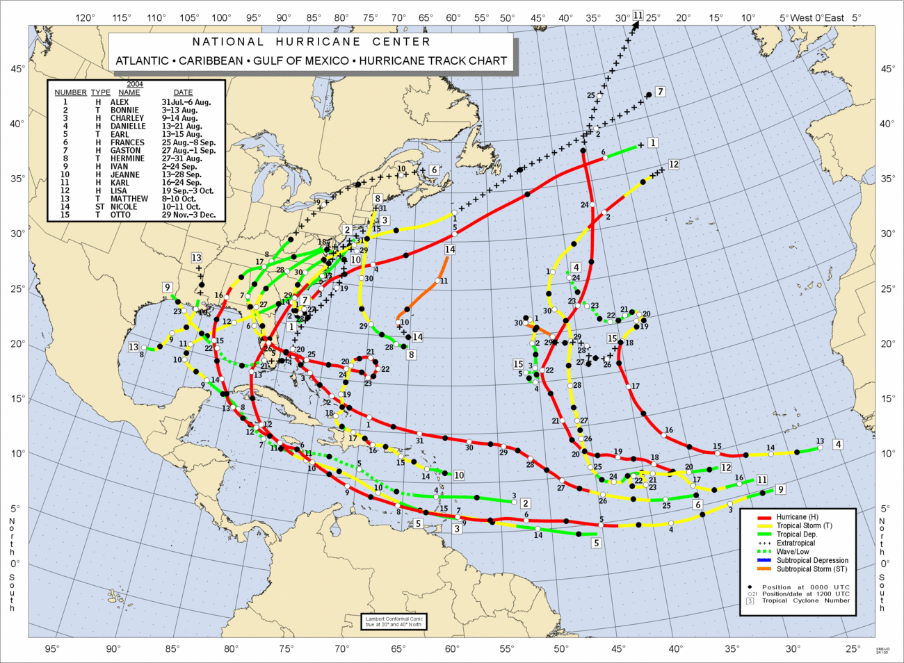
I know Inda, I hate that it's coming your way, and Hanna may possibly swing around and get us over here. I'm not sure though, that your spinning mass idea is completely valid. Here is an NHC plot of the 2004 season (http://www.nhc.noaa.gov/tracks/2004atl.gif), and you can see that Charlie crossed Cuba on the western end and moved straight across. And Ivan (track 9) jogged west when it hit Jamaica:
0 likes
gusty showers and winds in se. florida
nice band of rain offshore Palm beach (outskirts of gustav)?
http://radar.weather.gov/ridge/radar.ph ... 1&loop=yes
nice band of rain offshore Palm beach (outskirts of gustav)?
http://radar.weather.gov/ridge/radar.ph ... 1&loop=yes
0 likes
-
tolakram
- Admin
- Posts: 20183
- Age: 62
- Joined: Sun Aug 27, 2006 8:23 pm
- Location: Florence, KY (name is Mark)
Re: Cat. 3 Hurricane Gustav in NW Caribbean Sea
cpdaman wrote:tolakram wrote:http://hadar.cira.colostate.edu/ramsdis/online/trop_ge_storm_relative_0.html
Moving west now, mostly. Watch those wobbles!!
word of caution reading direction with a visible loop that is also panning west as it loops creates a lot of illusions
Very true, as I pointed out a couple of days ago, but see how it's at the top of the image and it's scrolling west? Also put your mouse cursor on the eye and see if it moves off of it as the loop scrolls. It's moving darn close to due west. It's a lot easier to track when they have eyes.
But I have no illusions, these storms don't move in straight lines they stair step or wobble around.
I wish they would recenter it.

0 likes
-
CrazyC83
- Professional-Met

- Posts: 34315
- Joined: Tue Mar 07, 2006 11:57 pm
- Location: Deep South, for the first time!
Re: Cat. 3 Hurricane Gustav in NW Caribbean Sea
vaffie wrote:948.2 mb reported by the NOAA airplane with 132 flight level winds
That would be a Cat 4 as that supports 120 kt from its level...
0 likes
Who is online
Users browsing this forum: No registered users and 20 guests