ATL GUSTAV: Tropical Depression - Discussion
Moderator: S2k Moderators
-
Derek Ortt
-
tolakram
- Admin

- Posts: 20183
- Age: 62
- Joined: Sun Aug 27, 2006 8:23 pm
- Location: Florence, KY (name is Mark)
Re: Cat. 3 Hurricane Gustav in NW Caribbean Sea
Sanibel wrote:Don't assume what they "are probably" doing. They KNOW what they're doing, and if they say it's a NNW wobble I'll take their word — they're the experts, you're not.
I doubt you could find any radar or loop that showed any NNW component. Sorry.
We don't need any more comic relief in this thread. Stop with your faux knowledge posts and this idea that you know more or can observe better than the hurricane center with trained experienced mets and high res high speed satellite imagery.
0 likes
-
Air Force Met
- Military Met

- Posts: 4372
- Age: 57
- Joined: Tue Jul 08, 2003 9:30 am
- Location: Roan Mountain, TN
Re: Cat. 3 Hurricane Gustav in NW Caribbean Sea
ALhurricane wrote: I am very interested to see what this does intensity wise in the Gulf. Does it weaken well before landfall or perhaps weaken just prior to landfall like Ivan and Katrina. That will make a big difference obviously. The upper trough on water vapor is beginning to retreat to the south and west, so it will be interesting to see just how much shear will occur over the storm. If Gustav stays a little east of the current track, then it may be in an ideal location to be well ventilated by the trough to the west.
I agree. There is still some undercutting shear going on right now...maybe enough to keep it from being a 5. Once in the Gulf...I've been leary of the shear that is forecasted. To me...if there is that kind of shear...it would force the track a little to the right towards NOLA as a weaker storm. I think this trof will be out of the way and replaced by that high that is dipping down thru Al/GA. That means intensity is going to be limited by dry air from land and lower TCHP...so a Katrina/Rita/Ivan scenario is possible.
0 likes
Re:
Derek Ortt wrote:its moving on the Cuban radar... may go east of Isle of Youth and into Havana unless it gets back on track
looks to me like it is back on track and going to head right over the isle of youth actually looks like a short term WNW/NW heading IMO
0 likes
-
soonertwister
- Category 5

- Posts: 1091
- Joined: Mon Jun 16, 2003 2:52 pm
Re: Cat. 3 Hurricane Gustav in NW Caribbean Sea
Can we bring the tension level down here a little bit? I'm not surprised that people are concerned about the direction of this storm, movement now could impact the ultimate place where Gustav hits the coast. This is a general discussion forum on Gustav. I think if people's posts are upsetting, it's best just to ignore them.
0 likes
-
jasons2k

- Storm2k Executive
- Posts: 8290
- Age: 52
- Joined: Wed Jul 06, 2005 12:32 pm
- Location: The Woodlands, TX
Re: ATL: Hurricane Gustav in NW Caribbean Sea
This is from 6:30PM last night but I wanted to bump it as a reminder that this will not follow a straight line. The overall track reasoning is still pretty much the same.
wxman57 wrote:
I've been looking at Gustav alone since 4am. Just got home from a 13 hour shift. About 10 more of those to go, maybe. We actually came up with the exact same track as the NHC an hour before they put theirs out this afternoon. But it does look strange tracking in such a straight line. I think it may bend right a bit after crossing Cuba then back left as it nears the coast of Louisiana. It would take just a tiny left bend near landfall to put the center into Sabine Pass or the upper TX coast (east of Galveston).
I always throw out the NOGAPS as a hurricane model (NAM, too). But the consensus models do use the NOGAPS as a member, so they've been shifted slightly left by the left-leaning NOGAPS today. I think if Gustav deviates from the track, then it may move ashore a bit farther west in SW LA.
Looks like it'll be a Cat 3 by tomorrow morning the way it's going now. I have it to 130 mph in the Gulf. Could be stronger. Will probably weaken a bit before landfall due to increasing shear.
0 likes
-
Harry Cane

- Tropical Low

- Posts: 33
- Joined: Tue Aug 21, 2007 11:23 pm
- Location: Asia
- Contact:
Re: Cat. 3 Hurricane Gustav in NW Caribbean Sea
I have been following Gustav on cuban radar since this afternoon Asia time and I believe there is a slight change in track . It's drifting more to the NNW

0 likes
Re: Cat. 3 Hurricane Gustav in NW Caribbean Sea
I agree, it's stair stepping and there will be wobble NNW and WNW=NW.
More likely trochoidal loops. (Strengthening).
Last edited by Sanibel on Sat Aug 30, 2008 9:49 am, edited 1 time in total.
0 likes
-
Mattie

- S2K Supporter

- Posts: 583
- Joined: Thu Sep 11, 2003 7:44 pm
- Location: North Texas (formerly South Louisiana)
- Contact:
Betsy (1965) is the last BIG hurricane that I know of that had impact north of the coast. The eye traveled over the Baton Rouge area. It came in at New Orleans - interesting comparison.
Hurricane Betsy slammed into New Orleans on the evening of September 9th, 1965. 110 mph winds and power failures were reported in New Orleans. [4] The eye of the storm passed to the southwest of New Orleans on a northwesterly track. The northern and western eyewalls covered Southeast Louisiana and the New Orleans area from about 8 pm until 4 am the next morning. In Thibodaux winds of 130 mph to 140 mph were reported. [5] The Baton Rouge weather bureau operated under auxiliary power, without telephone communication. [6] Around 1 am, the worst of the wind and rain was over.
Betsy also drove a storm surge into Lake Pontchartrain, just north of New Orleans, and the Mississippi River Gulf Outlet, a deep-water shipping channel to the east and south. Levees for the Mississippi River Gulf Outlet along Florida Avenue in the Lower Ninth Ward and on both sides of the Industrial Canal failed. The flood water reached the eaves of houses in some places and over some one story roofs in the Lower Ninth Ward. Some residents drowned in their attics trying to escape the rising waters.
These levee breaches flooded parts of Gentilly, the Upper Ninth Ward, and the Lower Ninth Ward of New Orleans as well as Arabi and Chalmette in neighboring St. Bernard Parish. President Lyndon Johnson visited the city, promising New Orleans Mayor Vic Schiro federal aid.
It was ten days or more before the water level in New Orleans went down enough for people to return to their homes. It took even longer than that to restore their flooded houses to a livable condition. Those who did not have family or friends with dry homes had to sleep in the shelters at night and forage for supplies during the day, while waiting for the federal government to provide emergency relief in the form of trailers.
In all, 164,000 homes were flooded at the second landfall.
Evidence suggests that cheap construction and poor maintenance of the structures led to the failure of the levees. However, popular rumor persists that they were intentionally breached, possibly as a means of salvaging the more prosperous French Quarter.[7] Similar rumors abound in the wake of Hurricane Katrina.
0 likes
-
Texashawk

- Category 2

- Posts: 579
- Joined: Tue Aug 14, 2007 1:50 am
- Location: Missouri City, TX (Houston)
Re: Cat. 3 Hurricane Gustav in NW Caribbean Sea
soonertwister wrote:Can we bring the tension level down here a little bit? I'm not surprised that people are concerned about the direction of this storm, movement now could impact the ultimate place where Gustav hits the coast. This is a general discussion forum on Gustav. I think if people's posts are upsetting, it's best just to ignore them.
I think people are upset because this is looking more and more like a doomsday slot machine event: Someone's getting a catastrophic surge, someone's getting potentially catastrophic winds, and someone's getting potentially catastrophic flooding. And the kicker is, it looks more and more like there will be 3 separate and distinct areas that get each 'symbol'. So yeah, people who have to pull the handle down here are probably a little antsy. I don't blame them.
0 likes
-
tolakram
- Admin
- Posts: 20183
- Age: 62
- Joined: Sun Aug 27, 2006 8:23 pm
- Location: Florence, KY (name is Mark)
Re: Cat. 3 Hurricane Gustav in NW Caribbean Sea
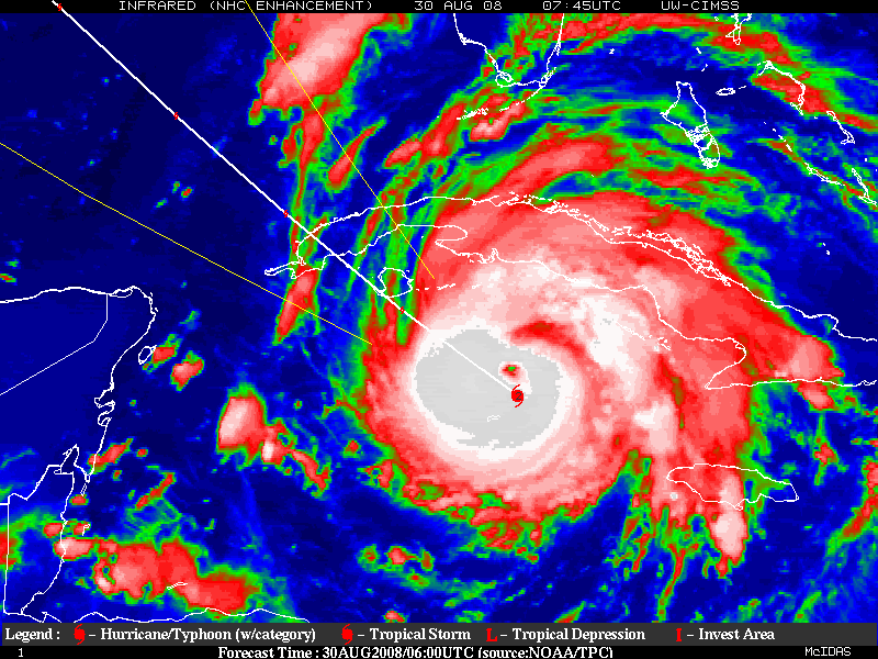
North wobble in the last few minutes.
edit: the image in the previous post does show the short n/nw movement.
http://hadar.cira.colostate.edu/ramsdis ... ive_0.html
higher res but older pics.
http://weather.msfc.nasa.gov/cgi-bin/ge ... olor=white
I don't have any high speed or high resolution imagery from prior to 8am that may or may not show a north / north west motion but I continue to trust what the NHC says. I think it's safe to assume they have tools and views available to them that we don't. I've also noted that while the forecast points show Gustav moving toward the NW somehow the eye has moved to the right of those points.

The right side of NW is N/NW unless they changed the compass on me.
The loop above was built using the build-your-own tool provided by nasa. Youc an change the link below to view what you want to view:
Full instructions on this page:
http://weather.msfc.nasa.gov/GOES/getsatellite.html
edit: the image in the previous post does show the short n/nw movement.
http://hadar.cira.colostate.edu/ramsdis ... ive_0.html
higher res but older pics.
http://weather.msfc.nasa.gov/cgi-bin/ge ... olor=white
I don't have any high speed or high resolution imagery from prior to 8am that may or may not show a north / north west motion but I continue to trust what the NHC says. I think it's safe to assume they have tools and views available to them that we don't. I've also noted that while the forecast points show Gustav moving toward the NW somehow the eye has moved to the right of those points.
The right side of NW is N/NW unless they changed the compass on me.
The loop above was built using the build-your-own tool provided by nasa. Youc an change the link below to view what you want to view:
Code: Select all
http://weather.msfc.nasa.gov/cgi-bin/get-goes?satellite=GOES-8%20HURRICANE&lat=20&lon=-79&map=standard&zoom=1&info=vis&quality=95&type=Animation&numframes=12&width=1200&height=800&palette=ir.pal&mapcolor=whiteFull instructions on this page:
http://weather.msfc.nasa.gov/GOES/getsatellite.html
Last edited by tolakram on Sat Aug 30, 2008 10:02 am, edited 1 time in total.
0 likes
-
crazycajuncane

- S2K Supporter
- Posts: 1097
- Joined: Sun Aug 15, 2004 2:51 pm
- Location: Lafayette, Louisiana
- Contact:
Re: Cat. 3 Hurricane Gustav in NW Caribbean Sea
0 likes
-
GeneratorPower

- S2K Supporter
- Posts: 1648
- Age: 46
- Joined: Sun Dec 18, 2005 11:48 pm
- Location: Huntsville, AL
Re: Cat. 3 Hurricane Gustav in NW Caribbean Sea
This is going to get a good piece of Juventude.
0 likes


Re: Cat. 3 Hurricane Gustav in NW Caribbean Sea
O Town, I was checking out a sat loop and it appears that was as far out as it got. The eye seems to have been wobbling. At one point it seemed pretty far off but it wobbled back towards the line shortly following in the loop ... It seems to the right of track but following it parallel.
0 likes
Who is online
Users browsing this forum: No registered users and 24 guests