
Would this also be true of the west coast of Fl?
Thanks for all the help in my learning experienes here at Storm2k.
WhirlWInd
ATL GUSTAV: Tropical Depression - Discussion
Moderator: S2k Moderators
-
x-y-no

- Category 5

- Posts: 8359
- Age: 65
- Joined: Wed Aug 11, 2004 12:14 pm
- Location: Fort Lauderdale, FL
Re: Re:
cpdaman wrote:x-y-no wrote:WhirlWind wrote:I have a question, with the cone looking so far away from Fl. why have they issuded warnings and watches for the Keys? Just asking and cotinuing to learn...Thanks
WhirlWind
Gustav has a large and still expanding wind field. Even if he goes exactly down the track, one can expect some TS gusts in Key West. Any track on the right side of the cone will bring sustained TS winds to the lower keys.
i wonder if any flooding would occur in key west near time of high tide
Unless the track is well to the right hand side of the cone, I don't expect much flooding in the keys.
0 likes

Re: Cat. 3 Hurricane Gustav in NW Caribbean Sea
deltadog03 wrote:OLook back a couple of pages at the steering flow.
Delta, latest steering....
http://cimss.ssec.wisc.edu/tropic/real- ... 8dlm6.html
dont think that weakness is going to be there in the next 3 hrs......not much of one left IMO...
0 likes
Re: Re:
cpdaman wrote:x-y-no wrote:WhirlWind wrote:I have a question, with the cone looking so far away from Fl. why have they issuded warnings and watches for the Keys? Just asking and cotinuing to learn...Thanks
WhirlWind
Gustav has a large and still expanding wind field. Even if he goes exactly down the track, one can expect some TS gusts in Key West. Any track on the right side of the cone will bring sustained TS winds to the lower keys.
i wonder if any flooding would occur in key west near time of high tide
Probably won't have much time to build up a surge before passing them the keys.[/quote]
i think your right unless she slows when she is on the north coast of cuba
0 likes
-
Evac3
- Tropical Depression

- Posts: 60
- Joined: Sun Sep 23, 2007 1:59 pm
- Location: Orange County, Southeast Texas
It's Needed and Thanks
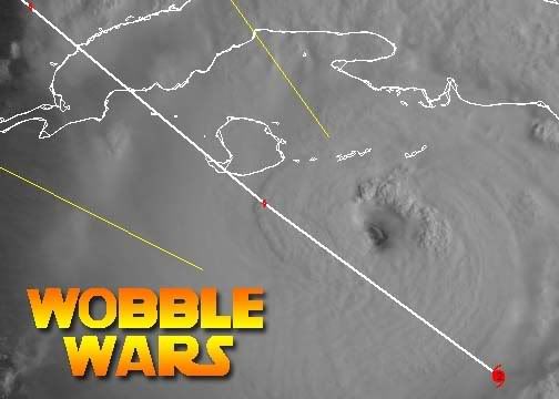
It's been said, but I wanna say it again... Thanks so much, tolakram for those great images. It really helps put an objective view on the wobbling.
Also wanna say that even though everybody keeps getting irritated with the "chat", good wishes, and prayers, those human connections mean a lot to some of us who are so worried. The facts are great, but a little human side is needed too. Science can't comfort me, but seeing other people as concerned as I am does.
Also wanna say that even though everybody keeps getting irritated with the "chat", good wishes, and prayers, those human connections mean a lot to some of us who are so worried. The facts are great, but a little human side is needed too. Science can't comfort me, but seeing other people as concerned as I am does.
0 likes


Re: Cat. 3 Hurricane Gustav in NW Caribbean Sea
My question is :
1) why on the west side of the storm is it flatten out north/south? (pic 1)
2) Is it because it is starting to feel the trough on th GOM? (pic 2)
3) Could this be causing the more nnw tracking over the last several hous?
4) Could it be feeling the weakness over the Eastern Gulf? (pic 3)


1) why on the west side of the storm is it flatten out north/south? (pic 1)
2) Is it because it is starting to feel the trough on th GOM? (pic 2)
3) Could this be causing the more nnw tracking over the last several hous?
4) Could it be feeling the weakness over the Eastern Gulf? (pic 3)
Last edited by TampaFl on Sat Aug 30, 2008 10:26 am, edited 1 time in total.
0 likes
-
tolakram
- Admin

- Posts: 20183
- Age: 62
- Joined: Sun Aug 27, 2006 8:23 pm
- Location: Florence, KY (name is Mark)
Re: Cat. 3 Hurricane Gustav in NW Caribbean Sea
Assuming it tracks to the right of the forecast track and closer to Havana it will be traversing flatter land. The mountains to the west of havana are not that high though, looks liek max elevation is 500m.

0 likes
-
soonertwister
- Category 5
- Posts: 1091
- Joined: Mon Jun 16, 2003 2:52 pm
Re: Re:
cpdaman wrote:
i wonder if any flooding would occur in key west near time of high tide
I think it's likely that they will have some minor flooding.
0 likes
-
Shockwave
- Tropical Storm

- Posts: 167
- Joined: Fri Jul 25, 2008 7:33 am
- Location: Lafayette, TN
- Contact:
Re: Cat. 3 Hurricane Gustav in NW Caribbean Sea
Does anyone know what the people of Pearlington, MS are doing to prepare? Thanks in advance for an answer.
0 likes
-
D3m3NT3DVoRT3X

- Tropical Low

- Posts: 31
- Age: 47
- Joined: Thu Aug 16, 2007 6:37 pm
- Location: The Burg < FL
Re: Cat. 3 Hurricane Gustav in NW Caribbean Sea
TampaFl wrote:My question is :
1) why on the west side of the storm is it flatten out north/south? (pic 1)
2) Is it because it is starting to feel the trough on th GOM? (pic 2)
3) Could this be causing the more nnw tracking over the last several hous?
4) Could it be feeling the weakness over the Eastern Gulf? (pic 3)
Tampa look at the steering flow
0 likes
-
Just Joshing You

- Category 2

- Posts: 512
- Joined: Sat Nov 03, 2007 10:29 am
- Location: Nova Scotia
Re: Re:
soonertwister wrote:cpdaman wrote:
i wonder if any flooding would occur in key west near time of high tide
I think it's likely that they will have some minor flooding.
How so? It won't have any storm surge accompanying it as it has to rebuild its lost storm surge once it crosses cuba. It doesn't just automatically get Cat 3-4 storm surge as soon as it hits land.
0 likes
-
Texashawk

- Category 2
- Posts: 579
- Joined: Tue Aug 14, 2007 1:50 am
- Location: Missouri City, TX (Houston)
Re: Cat. 3 Hurricane Gustav in NW Caribbean Sea
This may sound like a silly question, but if the short-term track is pushed more NNW due to Gus traveling more north than anticipated and being angled off the trough at a greater degree, say at a harder angle NW, would this change the long-term track appreciably? i.e. would the 'ricochet angle' make that much of a difference?
0 likes
-
Just Joshing You
- Category 2
- Posts: 512
- Joined: Sat Nov 03, 2007 10:29 am
- Location: Nova Scotia
Re: Cat. 3 Hurricane Gustav in NW Caribbean Sea
Texashawk wrote:This may sound like a silly question, but if the short-term track is pushed more NNW due to Gus traveling more north than anticipated and being angled off the trough at a greater degree, say at a harder angle NW, would this change the long-term track appreciably? i.e. would the 'ricochet angle' make that much of a difference?
Probably a little east.
0 likes
-
soonertwister
- Category 5
- Posts: 1091
- Joined: Mon Jun 16, 2003 2:52 pm
Re: Cat. 3 Hurricane Gustav in NW Caribbean Sea
Texashawk wrote:This may sound like a silly question, but if the short-term track is pushed more NNW due to Gus traveling more north than anticipated and being angled off the trough at a greater degree, say at a harder angle NW, would this change the long-term track appreciably? i.e. would the 'ricochet angle' make that much of a difference?
I said minor flooding. Key West is very close to sea level, it doesn't take much of a rise for things to get a little wet. It's hardly uncommon there.
0 likes
Re: Cat. 3 Hurricane Gustav in NW Caribbean Sea
Creepy. I don't know but this image
reminded me of this one

reminded me of this one
0 likes
Re: Re:
Just Joshing You wrote:soonertwister wrote:cpdaman wrote:
i wonder if any flooding would occur in key west near time of high tide
I think it's likely that they will have some minor flooding.
How so? It won't have any storm surge accompanying it as it has to rebuild its lost storm surge once it crosses cuba. It doesn't just automatically get Cat 3-4 storm surge as soon as it hits land.
the south east and then SSE winds will be blowing (well north east of the center over the fla strits) BEFORE she finishes crossing cuba and thus will have appox 12 or so hours to build up a lil flooding potential, and no just joshing you certainly not a cat3/4 surge, no body said that, they said minor
Last edited by cpdaman on Sat Aug 30, 2008 10:35 am, edited 1 time in total.
0 likes
-
tolakram
- Admin
- Posts: 20183
- Age: 62
- Joined: Sun Aug 27, 2006 8:23 pm
- Location: Florence, KY (name is Mark)
Re: Cat. 3 Hurricane Gustav in NW Caribbean Sea
Track updates, still to the right. 

Personal Forecast Disclaimer:
The posts in this forum are NOT official forecast and should not be used as such. They are just the opinion of the poster and may or may not be backed by sound meteorological data. They are NOT endorsed by any professional institution or storm2k.org. For official information, please refer to the NHC and NWS products.
I'm of the opinion that the track shape won't change but if initialized more the the right they will all shift more to the right. It's all about where they initialize before each run. Beyond that I woudl just watch and see. If you're in the cone you should already be ready to go anyway because these storms are large and even if on the track a wobble just before landfall could mean a direct hit. Don't focus on the lines focus on the cone, which is the margin of error from past forecasting experience.
0 likes
Re: Cat. 3 Hurricane Gustav in NW Caribbean Sea
Sanibel wrote:No ULL or Hanna to the east of Camille.
how can you tell from that, its not water vapor, and it doesn't pan to the current location of where the ull is now anyway ?????
0 likes
Who is online
Users browsing this forum: No registered users and 25 guests