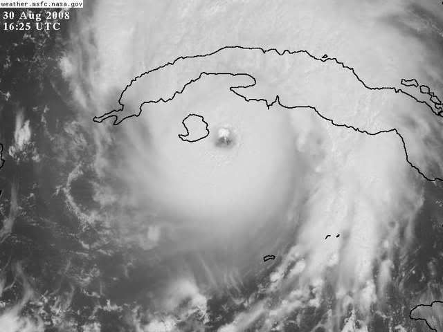
ATL GUSTAV: Tropical Depression - Discussion

Moderator: S2k Moderators

Message
Author
User avatar
bvigal
S2K Supporter
S2K Supporter
Posts: 2276
Joined: Sun Jul 24, 2005 8:49 am
Location: British Virgin Islands
Contact:

Re: Re:

#6781 Postby bvigal » Sat Aug 30, 2008 11:31 am

Harry Cane wrote:
Cuban radar site appears to be either down, or overloaded.


Here we go

(intentionally omitted Harry Cane's link to insert LIVE LOOP into S2K thread)

I can't believe you are linking a live radar loop, and one that is overloaded, at that, so just slows down this thread rendering. I've been bumped off here twice because bandwidth is so busy. No wonder.

Be safe, Tim!
0 likes   

tolakram
Admin
Admin
Posts: 20167
Age: 62
Joined: Sun Aug 27, 2006 8:23 pm
Location: Florence, KY (name is Mark)

Re: Cat. 3 Hurricane Gustav in NW Caribbean Sea

#6782 Postby tolakram » Sat Aug 30, 2008 11:31 am

PTPatrick wrote:I AM NOT A HISTORY HUGGER, JUST FIND THIS INTERESTING....If you look at the historical tracks on Wunderground...no August cat 3,4, 5 within 400 miles of where Gus is now have ever hit Lousisana...in fact there is just one that hit near houston, and one that hit Hancock County mississippi, and that was a lady named Camile...but alas she was no lady.


Which is why using climatology to predict storm landfall locations is useless; too few data points to make any meaningful conclusion. Of course Gustav will strike in September, not August. :)
0 likes   

Nederlander
S2K Supporter
S2K Supporter
Posts: 1252
Joined: Sat Jul 19, 2008 4:28 pm
Location: Conroe, TX

Re: Cat. 3 Hurricane Gustav in NW Caribbean Sea

#6783 Postby Nederlander » Sat Aug 30, 2008 11:36 am

njweather wrote:
Also, I know Western Cuba is flat relative to its Eastern half, but there are some "mountains" there:

http://maps.google.com/maps?q=elevation ... 24&t=p&z=9

Does anyone know if these are high enough to be disruptive?


they arent extremely high mountains, shouldnt weaken it very much
0 likes   

User avatar
HURAKAN
Professional-Met
Professional-Met
Posts: 46086
Age: 38
Joined: Thu May 20, 2004 4:34 pm
Location: Key West, FL
Contact:

#6784 Postby HURAKAN » Sat Aug 30, 2008 11:38 am

A recent example of how the topography of Pinar del Río, Cuba, can influence a tropical cyclone intensity was Hurricane Lily that moved in a very similar path to Gustav's and its intensity remained at 90 knots during the passage.
0 likes   

User avatar
Yankeegirl
Category 5
Category 5
Posts: 3417
Age: 49
Joined: Sun May 23, 2004 11:59 pm
Location: Cy-Fair, Northwest Houston
Contact:

#6785 Postby Yankeegirl » Sat Aug 30, 2008 11:38 am

ok,.... so i have a quick question... I am in Houston and it looks like Gus is going into LA then turning to the west.... what effects might we feel here? This storm looks huge! We have to have something, right?
0 likes   

cpdaman
Category 5
Category 5
Posts: 3131
Joined: Sat Jun 10, 2006 11:44 am
Location: SPB county (gulf stream)

Re: Cat. 3 Hurricane Gustav in NW Caribbean Sea

#6786 Postby cpdaman » Sat Aug 30, 2008 11:39 am

key west long range radar looks........very stormy for the western end of the keys

http://radar.weather.gov/ridge/radar.ph ... 1&loop=yes

any posters in key west? strong feeder band to the se gonna move thru in about two hours
Last edited by cpdaman on Sat Aug 30, 2008 11:40 am, edited 2 times in total.
0 likes   

User avatar
HURAKAN
Professional-Met
Professional-Met
Posts: 46086
Age: 38
Joined: Thu May 20, 2004 4:34 pm
Location: Key West, FL
Contact:

#6787 Postby HURAKAN » Sat Aug 30, 2008 11:39 am

Image

Image
0 likes   

meteorologyman
Category 2
Category 2
Posts: 541
Joined: Wed Mar 15, 2006 6:48 pm
Location: Florida, Kissimmee/St.CLoud

Re:

#6788 Postby meteorologyman » Sat Aug 30, 2008 11:42 am

Yankeegirl wrote:ok,.... so i have a quick question... I am in Houston and it looks like Gus is going into LA then turning to the west.... what effects might we feel here? This storm looks huge! We have to have something, right?


Too dificult to say, if it misses LA and stays off land you may feel strong effects, if it moves inland then come into your area you may feel TS force conditons
Last edited by meteorologyman on Sat Aug 30, 2008 11:42 am, edited 1 time in total.
0 likes   

Nederlander
S2K Supporter
S2K Supporter
Posts: 1252
Joined: Sat Jul 19, 2008 4:28 pm
Location: Conroe, TX

Re:

#6789 Postby Nederlander » Sat Aug 30, 2008 11:42 am

Yankeegirl wrote:ok,.... so i have a quick question... I am in Houston and it looks like Gus is going into LA then turning to the west.... what effects might we feel here? This storm looks huge! We have to have something, right?


depends on landfall and where that ridge is going to be at that time.. if its bends SW AFTER landfall, then itll be significantly weaker, but moving much slower too.. lots of rain... with Gus's large wind field, that area may experience TS winds, but if the forecast is correct then it shouldnt be anything major... too early to tell though
0 likes   

Stormcenter
S2K Supporter
S2K Supporter
Posts: 6685
Joined: Wed Sep 03, 2003 11:27 am
Location: Houston, TX

Re: Cat. 3 Hurricane Gustav in NW Caribbean Sea

#6790 Postby Stormcenter » Sat Aug 30, 2008 11:43 am

PTPatrick wrote:I AM NOT A HISTORY HUGGER, JUST FIND THIS INTERESTING....If you look at the historical tracks on Wunderground...no August cat 3,4, 5 within 400 miles of where Gus is now have ever hit Lousisana...in fact there is just one that hit near houston, and one that hit Hancock County mississippi, and that was a lady named Camile...but alas she was no lady.


Yeah I've mentioned that before on other posts. I have my doubts Gustav will be a 3,4 or 5 when he makes
land somewhere along the Gulf coast. JMHO
0 likes   

Brent
S2K Supporter
S2K Supporter
Posts: 38394
Age: 37
Joined: Sun May 16, 2004 10:30 pm
Location: Tulsa Oklahoma
Contact:

Re:

#6791 Postby Brent » Sat Aug 30, 2008 11:44 am

HURAKAN wrote:Image


Is that a stadium effect in the eye?

If recon doesn't find a Cat 4 I'll be shocked. Cuba is going to get slammed.
0 likes   

meteorologyman
Category 2
Category 2
Posts: 541
Joined: Wed Mar 15, 2006 6:48 pm
Location: Florida, Kissimmee/St.CLoud

Re: Cat. 3 Hurricane Gustav in NW Caribbean Sea

#6792 Postby meteorologyman » Sat Aug 30, 2008 11:45 am

There is no good scenario for this storm.
if hits LA as a major it will see catastrophic damage.
If it takes a westward track then the Oil Rigs will take a HEAVY BEATING
0 likes   

BigB0882
S2K Supporter
S2K Supporter
Posts: 2285
Joined: Thu Jul 03, 2003 12:08 am
Location: Baton Rouge, LA
Contact:

Re: Cat. 3 Hurricane Gustav in NW Caribbean Sea

#6793 Postby BigB0882 » Sat Aug 30, 2008 11:45 am

Stormcenter wrote:
PTPatrick wrote:I AM NOT A HISTORY HUGGER, JUST FIND THIS INTERESTING....If you look at the historical tracks on Wunderground...no August cat 3,4, 5 within 400 miles of where Gus is now have ever hit Lousisana...in fact there is just one that hit near houston, and one that hit Hancock County mississippi, and that was a lady named Camile...but alas she was no lady.


Yeah I've mentioned that before on other posts. I have my doubts Gustav will be a 3,4 or 5 when he makes
land somewhere along the Gulf coast. JMHO


Well, this hurricane will not be hitting in August. Does that change the statistics any or are you only referring to cyclones FORMED in August?
0 likes   

User avatar
Janie2006
Category 5
Category 5
Posts: 1329
Joined: Mon Sep 18, 2006 3:28 pm
Location: coastal Ms aka home of the hurricanes

#6794 Postby Janie2006 » Sat Aug 30, 2008 11:46 am

I'd be willing to bet it's a Cat 4. That eye structure is impressive.
0 likes   

User avatar
Cape Verde
Category 2
Category 2
Posts: 564
Age: 70
Joined: Tue Aug 31, 2004 5:53 pm
Location: Houston area

Re: Cat. 3 Hurricane Gustav in NW Caribbean Sea

#6795 Postby Cape Verde » Sat Aug 30, 2008 11:46 am

The 100,000 residents of the Isle of Youth are about to have an exciting Saturday.
0 likes   

Solaris
Tropical Storm
Tropical Storm
Posts: 222
Joined: Sun Aug 28, 2005 4:54 am

Re: Cat. 3 Hurricane Gustav in NW Caribbean Sea

#6796 Postby Solaris » Sat Aug 30, 2008 11:49 am

Sherrif from Placquemines Parish/New Orleans on WDSU TV at the moment. Confirms mandatory evacuation starts at NOON local time and also CURFEW overnight, people roaming the streets for no good reason will be arrested.
0 likes   

meteorologyman
Category 2
Category 2
Posts: 541
Joined: Wed Mar 15, 2006 6:48 pm
Location: Florida, Kissimmee/St.CLoud

Re: Cat. 3 Hurricane Gustav in NW Caribbean Sea

#6797 Postby meteorologyman » Sat Aug 30, 2008 11:50 am

Cape Verde wrote:The 100,000 residents of the Isle of Youth are about to have an exciting Saturday.


I woldn't call a CAT3 or even a Cat4 slamming into your area would be considered exciting, but i know, I think you're speaking sarcasm.
0 likes   

Stormcenter
S2K Supporter
S2K Supporter
Posts: 6685
Joined: Wed Sep 03, 2003 11:27 am
Location: Houston, TX

Re: Cat. 3 Hurricane Gustav in NW Caribbean Sea

#6798 Postby Stormcenter » Sat Aug 30, 2008 11:50 am

meteorologyman wrote:There is no good scenario for this storm.
if hits LA as a major it will see catastrophic damage.
If it takes a westward track then the Oil Rigs will take a HEAVY BEATING


Your are missing the possibility of it encountering shear in the
GOM and hopefully weakening it. That would be the BEST scenario
for everyone.
0 likes   

User avatar
HURAKAN
Professional-Met
Professional-Met
Posts: 46086
Age: 38
Joined: Thu May 20, 2004 4:34 pm
Location: Key West, FL
Contact:

#6799 Postby HURAKAN » Sat Aug 30, 2008 11:51 am

Image
0 likes   

CrazyC83
Professional-Met
Professional-Met
Posts: 34308
Joined: Tue Mar 07, 2006 11:57 pm
Location: Deep South, for the first time!

#6800 Postby CrazyC83 » Sat Aug 30, 2008 11:51 am

We have (at least) a Cat 4 now. 127 kt FL winds supports 114 kt at the surface.
0 likes   


Return to “2008”

Who is online

Users browsing this forum: No registered users and 35 guests