

Derek,Best track has 948 mbs lower than the VDM:
AL, 07, 2008083100, , BEST, 0, 227N, 834W, 125, 948, HU, 64, NEQ
ATL GUSTAV: Tropical Depression - Discussion
Moderator: S2k Moderators
Mandatory evacuation for New Orleans
8am--West Bank
Noon--East Bank
Nagin says he wants EVERYONE out of the city
Press conference: http://www.fox8live.com/www/Video/wvuehigh.asx
8am--West Bank
Noon--East Bank
Nagin says he wants EVERYONE out of the city
Press conference: http://www.fox8live.com/www/Video/wvuehigh.asx
0 likes


Re: Cat. 4 Hurricane Gustav over Western Cuba
This should be taken to another message since we are dealing with Gustav....but the link below will hopefully rest this debate over katrina....SE La was in the cone starting as far out as 8/23/05. BY 48 hours from landfall, that area was not only in the cone, but also pretty much 'in the black line.'
http://www.nhc.noaa.gov/archive/2005/KATRINA_graphics.shtml
Apologies for going off topic with Gustav.
http://www.nhc.noaa.gov/archive/2005/KATRINA_graphics.shtml
Apologies for going off topic with Gustav.
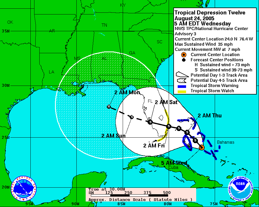
Calistar wrote:senorpepr wrote:peteywheatstraw wrote:The cone of uncertainty is not infallible. 48 hrs before Katrina made landfall it wasn't even in SE La.
I'm throwing a BS flag here. If you check out advisory number ONE... (about six days out), New Orleans was in the cone.
Senor, as someone who lived in Slidell prior to Katrina and a member of this forum, it was projected to go into the panhandle of Florida... It seems to me that it took a major shift in the track because we had been watching it until Thursday... it was only on Friday morning before it hit that it came into the cone of concern... We didn't realize it until Friday night and left the next day... it hit the following Monday morning... that means it was 72 hrs. out before the cone of concern ever included N.O.
0 likes
-
wx247

- S2K Supporter

- Posts: 14279
- Age: 42
- Joined: Wed Feb 05, 2003 10:35 pm
- Location: Monett, Missouri
- Contact:
For what it is worth Mayor Ray Nagin of New Orleans just called this "The Storm of the Century" that will be "worse than Katrina." WOW! That is quite the hype.
Last edited by wx247 on Sat Aug 30, 2008 8:04 pm, edited 1 time in total.
0 likes
-
senorpepr

- Military Met/Moderator

- Posts: 12542
- Age: 43
- Joined: Fri Aug 22, 2003 9:22 pm
- Location: Mackenbach, Germany
- Contact:
Re: Cat. 4 Hurricane Gustav over Western Cuba
Calistar wrote:Senor, as someone who lived in Slidell prior to Katrina and a member of this forum, it was projected to go into the panhandle of Florida... It seems to me that it took a major shift in the track because we had been watching it until Thursday... it was only on Friday morning before it hit that it came into the cone of concern... We didn't realize it until Friday night and left the next day... it hit the following Monday morning... that means it was 72 hrs. out before the cone of concern ever included N.O.
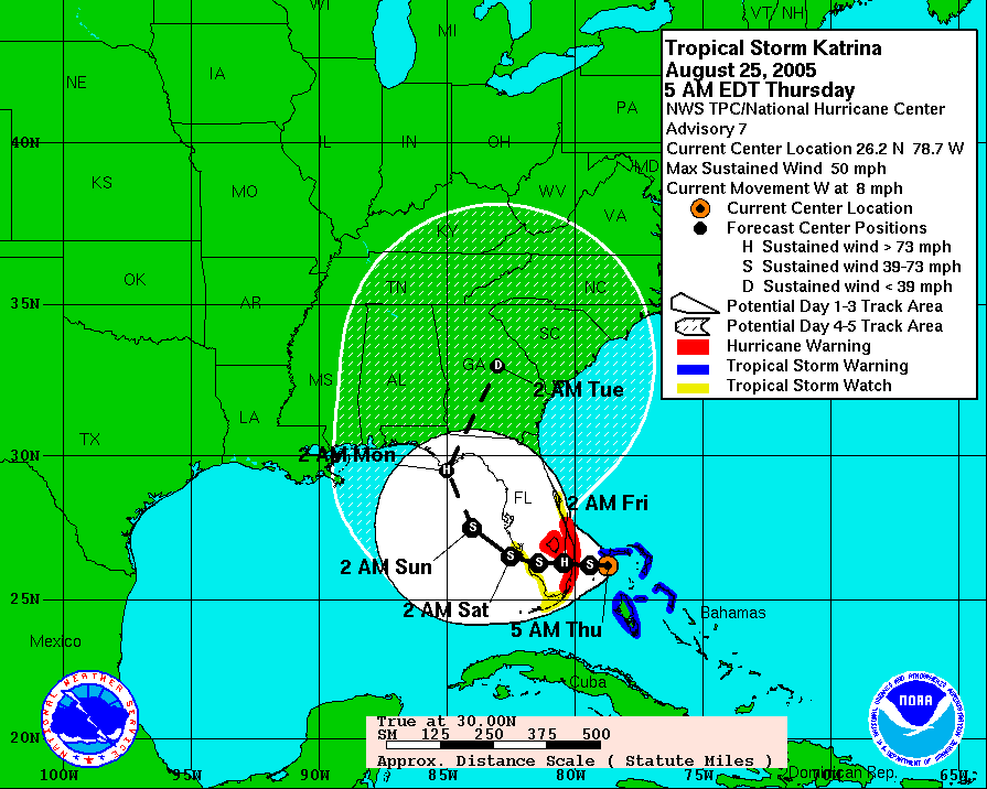
I realize that it was orginally projected into the FL panhandle, but I'm talking about the cone.
Advisory 1 (23rd 5pm EDT) has NO in the cone.
http://www.nhc.noaa.gov/archive/2005/gr ... 1205W5.GIF
I will say, advisories 6-10 had NO out of the cone, but after advisory 11 (26th 5am EDT) NO remained in the cone.
0 likes
-
Hybridstorm_November2001

- S2K Supporter
- Posts: 2817
- Joined: Sat Aug 21, 2004 2:50 pm
- Location: SW New Brunswick, Canada
- Contact:
Re: Cat. 4 Hurricane Gustav emerging Western Cuba
The city of NOLA is in a lot of trouble, putting it rather mildly. If it hits at the angle they say it will. I do not see how things could get much worse for the Big Easy. My toughts, and prayers, are with everyone on the North-Centeral GOM Coast. 
0 likes
-
AlabamaDave
- Tropical Storm

- Posts: 169
- Joined: Wed Aug 11, 2004 6:44 pm
Re: Cat. 4 Hurricane Gustav over Western Cuba
Calistar wrote:senorpepr wrote:peteywheatstraw wrote:The cone of uncertainty is not infallible. 48 hrs before Katrina made landfall it wasn't even in SE La.
I'm throwing a BS flag here. If you check out advisory number ONE... (about six days out), New Orleans was in the cone.
Senor, as someone who lived in Slidell prior to Katrina and a member of this forum, it was projected to go into the panhandle of Florida... It seems to me that it took a major shift in the track because we had been watching it until Thursday... it was only on Friday morning before it hit that it came into the cone of concern... We didn't realize it until Friday night and left the next day... it hit the following Monday morning... that means it was 72 hrs. out before the cone of concern ever included N.O.
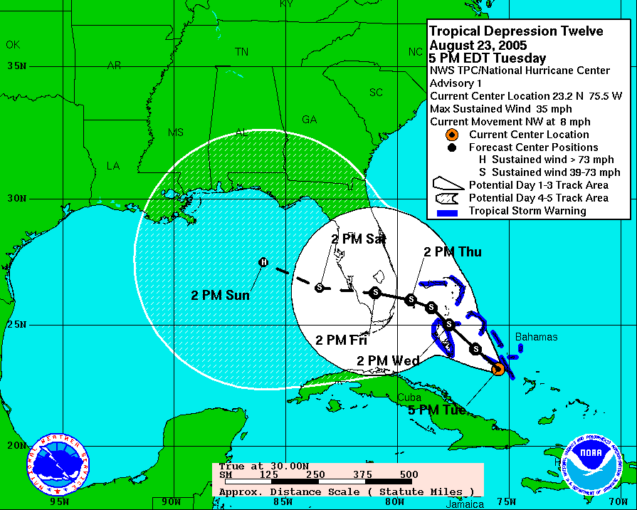
This is not entirely true. Here is an archived forecast map from Wed before Katrina hit LA/MS, and New Orleans is well within the cone:
Interestingly, by Thursday, the cone of uncertainty starts right around the LA/MS border:
0 likes

It appears my 145 knot prediction could be spot on.
That modis image that was posted hours back reminds me of Ivan, Felix, and Emily put together in terms of how it looks. Here is why:
Hurricane Felix (2007) (the eye)
Hurricane Ivan (2004) (the location and size)
Hurricane Emily (2005) (The outer rainbands look)
I wonder what kind of damage is occuring in Cuba.
0 likes

Re: Cat. 4 Hurricane Gustav emerging Western Cuba
Where is the map from on the active storms page???
0 likes

Re: Cat. 4 Hurricane Gustav emerging Western Cuba
http://icons-pe.wunderground.com/data/i ... _model.gif
NOW THATS CONSENSUS...
I DONT THINK SAYING THIS COULD BE WORSE THAN KAT FOR NOLA IS "HYPING". THE CONSENSUS IS NOW WELL EAST OF VERMILLION BAY. IN FACT...NHC TRACK IS ABOUT THE ONLY ONE STILL HUGGING VERMILLION. I WOULD NOT BE SURPRISED FOR THE 11 TRACK TO CALL FOR LANDFALL IN PLAQUEMINES OR LAFOURCHE AND TRACK RIGHT OVER WEST BATON ROUGE TOWARD ALEXANDRIA.
0 likes
-
stormy1970al

- Tropical Storm
- Posts: 158
- Age: 56
- Joined: Sat May 31, 2008 12:54 pm
- Location: Fairhope AL
Re: Cat. 4 Hurricane Gustav emerging Western Cuba
People lets please be civil to one another right now and stop arguing whether or not NOLA was in the cone during Katrina. That was three years ago and we can't change what happen that terrible day in August. What we can do right now is to learn from what happen that day and days after and makes this storm not the Storm of the Century as Nagin called it. There are going to be several States affected by Gustav and many people are coming to this site to get valuable information and prepare for a major hurricane and not to read an argument over a cone that concerns Katrina.
I have been coming to this site since 2004 when Ivan hit my hometown. This site probably has saved me from losing my mind during major storms. I appreciated the mods and the pro-mets that provide their extra time to help out here. They are wonderful. I know everyone is nervous about this storm. I know I am and my main concern is to be prepared for the event of a major hurricane.
So as the next two days lets remember those in the path of Gustav and pray for them. For those in the path be prepare! Don't panic! Listen to what is going on.
0 likes
-
ConvergenceZone
.gif)
- Category 5

- Posts: 5241
- Joined: Fri Jul 29, 2005 1:40 am
- Location: Northern California
Re:
Janie2006 wrote:Hurricanes in the Atlantic basin generally maintain Cat 5 strength for only a limited amount of time. If he's going to do it, I'd prefer it to be sooner rather than later.
It's funny that you mentioned that, because I remember a discussion, not sure if it was from the NHC or the Jeff Masters blog, that's it much better if a storm reaches it's peak early, because then, the chance of it landfalling as a cat 4/cat5 is greatly reduced. Still, a cat 3 storm can do much damage, and I can't see this weakening below a cat 3, even with a bit of shear and cool temperatures off the coast. I guess it's possible, but still think a cat 3 is the most likely scenerio right now.
0 likes

Re: Cat. 4 Hurricane Gustav emerging Western Cuba
Looks like eye is over water on Key West long range radar
0 likes
Re:
Janie2006 wrote:Hurricanes in the Atlantic basin generally maintain Cat 5 strength for only a limited amount of time. If he's going to do it, I'd prefer it to be sooner rather than later.
Good point about that Janie I had totally forgotten that aspect.
0 likes
Re: Cat. 4 Hurricane Gustav emerging Western Cuba
Is the belief that strong Hurricanes make their own paths still around?? I remember years ago people would always quote this. Prolly before models were good. 
0 likes
-
wxman57

- Moderator-Pro Met

- Posts: 23172
- Age: 68
- Joined: Sat Jun 21, 2003 8:06 pm
- Location: Houston, TX (southwest)
Re: Cat. 4 Hurricane Gustav emerging Western Cuba
PTPatrick wrote:http://icons-pe.wunderground.com/data/images/at200807_model.gif
NOW THATS CONSENSUS...
I DONT THINK SAYING THIS COULD BE WORSE THAN KAT FOR NOLA IS "HYPING". THE CONSENSUS IS NOW WELL EAST OF VERMILLION BAY. IN FACT...NHC TRACK IS ABOUT THE ONLY ONE STILL HUGGING VERMILLION. I WOULD NOT BE SURPRISED FOR THE 11 TRACK TO CALL FOR LANDFALL IN PLAQUEMINES OR LAFOURCHE AND TRACK RIGHT OVER WEST BATON ROUGE TOWARD ALEXANDRIA.
First of all, stop shouting. Second, the plot you posted has some of the worst hurricane models, including the BAMs and NOGAPS. See my post in the model thread about the BAMs. They should never be used in a changing steering flow. Here's a better plot. All tracks between Lafayette and Baton Rouge. There's no shift to New Orleans, but that doesn't mean this won't potentially be worse than Katrina there. New Orleans missed out on Katrina's strong winds. A track just west of New Orleans or to Baton Rouge would put New Orleans in the right front quadrant of a Cat 3-4 hurricane.
The orange track near Baton Rouge is NOGAPS - not a very good model for hurricanes.

0 likes
Who is online
Users browsing this forum: No registered users and 9 guests