ATL GUSTAV: Tropical Depression - Discussion
Moderator: S2k Moderators


-
mvtrucking

- S2K Supporter

- Posts: 698
- Age: 67
- Joined: Sat Jul 09, 2005 10:01 am
- Location: Monroe,La
-
Matt-hurricanewatcher
Re:
KWT wrote:Well odds on a cat-5 seems to be gone, the system really left Cuba a lot messier then I thought it would but there you go!
I highly doubt this will become a cat5, but who's to say it is impossible over the loop. That is why I also say it is a wait and see.
0 likes
Problem is Mattits NE eyewall is pretty much gone, its down to half an eyewall on the SW side, very strong a sit is the system is pretty much lopsided right now. However thats not to say we can't get a big burst in the NE eyewall to close it back up again.
mvtrucking, we can hope but even that won't reduce the surge now sadly and thats going to be the big story I feel.
mvtrucking, we can hope but even that won't reduce the surge now sadly and thats going to be the big story I feel.
0 likes
-
attallaman
Re: Cat. 4 Hurricane Gustav in Gulf of Mexico
The Mississippi Gaming Commission has ordered that all casinos along the coast close at 7:00 a.m. today and Keesler Air Force Base which is located here in Biloxi and the headquarters for the Hurricane Hunters weather squadron has also ordered all non storm essential personell to evacuate the base later today beginning at 6:00 a.m. today and ending by 6:00 p.m. tonight.
I've been away from the computer for several hours, has the threat to the Mississippi Gulf Coast increased since last night when the NHC track indicated the hurricane making landfall west of NOLA? Has the NHC track shifted towards the east since last night?
According to the latest graphics from the NHC it still looks like the storm will make landfall west of NOLA. Fox Cable News late yesterday had one of their correspondents reporting live on the beach here in Biloxi and the caption under him said Biloxi, MS preparing for a direct hit from Gustav. I thought that caption was irresponsible. My phone started ringing off the hook after that guy was on from Fox News. It wouldn't surprise me if Jim Cantore was to show up here later today after Fox News comments.
0 likes

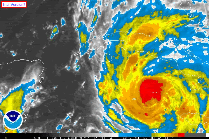
I think it will have an easier time putting itself together than Hurricane Dennis. And starting from a MUCH higher intensity. The sat pics I'm seeing tells me (as someone who does not know much) that Gustav is simply rebuilding and rewrapping his core. The pace has been steady and I think once all that new convection completely wraps around, we will see some strong drops in pressure.
Also, the focus on category 5 is something of a red herring. It should be able to reach no doubt cat 4 again and sustain it for a long while.
Also, the focus on category 5 is something of a red herring. It should be able to reach no doubt cat 4 again and sustain it for a long while.
0 likes

Well at 5:45z he was open SE and at 7z he was open NE, so maybe it is a transient condition. I have been watch the Key West long range http://radar.weather.gov/radar.php?rid= ... 1&loop=yes, but it is really getting too far. They should be turning for another pass pretty soon, so we should see then.
0 likes
Well ther eis new convection trying to wrap around in the northern eyewall, its really not all that impressive but its a start and the eye is clearing out again it seems so it may be about to strengthen just before the loop current.
As people have no doubt said anyway in the way of this as well as people in N.O should really get out of there, this will no doubt be a landflaling major hurricane IMO.
As people have no doubt said anyway in the way of this as well as people in N.O should really get out of there, this will no doubt be a landflaling major hurricane IMO.
0 likes
-
Matt-hurricanewatcher
Re: Cat. 4 Hurricane Gustav in Gulf of Mexico
Kwt there was also no doubt with LILI making landfall as a major intil it fall apart on many message boards like this one, also there was no idea that Katrina was going to weaking to a low end cat3 at its second landfall...Hell, many pepole throught katrina was going to hit as a cat5 not more then 6 hours before first landfall. Things change and can change very fast, in with strong upper level shear, it can do so even faster. If and there is always a if shear picks up more, this thing could come in as a high end cat1 with all we know.
Now a major is looking more likely at the moment, that I agree with you on.
Now a major is looking more likely at the moment, that I agree with you on.
0 likes
Gotta be patient (If you've put on the black cap and rooting for the hurricane...) Acording to this link, http://www.lawrencevilleweather.com/storms/2005/atlantic/dennis.html Dennis took 18 hours to really start booking in terms of strength building and he was fast. Gustav has more than enough time (about 15-16hrs)and fewer repairs to do for that 2-3 hrs worth of truly rapid deepening.
0 likes
-
USTropics
- Professional-Met

- Posts: 2738
- Joined: Sun Aug 12, 2007 3:45 am
- Location: Florida State University
Re:
shah8 wrote:I think it would be good if someone would post an animated .gif of Gustav from 100m SE of Grand Cayman until Isle of Youth. It might give insight to tendencies about building inner cores.
0 likes
True Matt though Lili was a small system, Gustav's a lot bigger. My personal landfall has been 120mph all along so I'll hold that for now, still a pretty severe hurricane really for LA, any major hurricane is very dangerous, even a high end 2 can be deadly, esp when the surge will be the most severe issue possibly.
0 likes
-
TCmet
- Professional-Met
- Posts: 106
- Age: 45
- Joined: Sat Jul 14, 2007 4:00 pm
- Location: New York, NY
- Contact:
Re: Cat. 4 Hurricane Gustav in Gulf of Mexico
Definitely growing in size right now, and I sense that the eye that emerges is going to be fairly small and tight.
0 likes
-
bostonseminole

- Tropical Storm

- Posts: 209
- Joined: Sun Sep 11, 2005 3:54 pm
- Location: Tokyo, Japan
Yep once the northern eyewall does close off then rapid drops in pressure looks probable again given the loop current. The main blessing is thats its further south than normal.
I think this will only just pass west of N.O.
I think this will only just pass west of N.O.
Last edited by KWT on Sun Aug 31, 2008 3:48 am, edited 1 time in total.
0 likes
-
USTropics
- Professional-Met
- Posts: 2738
- Joined: Sun Aug 12, 2007 3:45 am
- Location: Florida State University
Re: Cat. 4 Hurricane Gustav in Gulf of Mexico
Appears that the eyewall is being sheared somewhat from the south. CIMMS puts 20 knots currently over Gustav. Shear tendency shows it will begin to relax before once again returning in 24+ hours.
http://cimss.ssec.wisc.edu/tropic/real- ... g8shr.html - current shear
http://cimss.ssec.wisc.edu/tropic/real- ... g8sht.html - shear tendency
http://cimss.ssec.wisc.edu/tropic/real- ... g8shr.html - current shear
http://cimss.ssec.wisc.edu/tropic/real- ... g8sht.html - shear tendency
0 likes
Who is online
Users browsing this forum: No registered users and 27 guests