ATL GUSTAV: Tropical Depression - Discussion

Moderator: S2k Moderators

Message
Author
User avatar
HarlequinBoy
Category 5
Category 5
Posts: 1400
Age: 34
Joined: Wed Nov 29, 2006 1:57 am
Location: Memphis

Re:

#9301 Postby HarlequinBoy » Sun Aug 31, 2008 9:26 pm

Weatherfreak000 wrote:Per the latest satellite image the coldest cloud tops appear to be expanding from the SW and trying to wrap around the system. The dry air intrusion on the NE side appears to also be filling in.


Still intensifying. My hands are shaking so badly I can hardly type this.


Did you evacuate?
0 likes   

KBBOCA
S2K Supporter
S2K Supporter
Posts: 1559
Joined: Fri Sep 05, 2003 5:27 am
Location: Formerly Boca Raton, often West Africa. Currently Charlotte NC

#9302 Postby KBBOCA » Sun Aug 31, 2008 9:26 pm

Joining in all the prayers, and like VBHoutex, praying for all S2Kers whose locations indicate they are in Gustav's path.

A prayer I've found VERY helpful is here:
http://anglicanprayer.wordpress.com/200 ... tavs-path/
0 likes   

User avatar
MHurricanes
Tropical Storm
Tropical Storm
Posts: 102
Age: 73
Joined: Thu Aug 14, 2008 2:05 pm
Location: Altamonte Springs, FL
Contact:

Re: Cat 3 Hurricane Gustav in Gulf of Mexico

#9303 Postby MHurricanes » Sun Aug 31, 2008 9:28 pm

desertrat75 wrote:Uhh, yeah. These morons are in Houma, getting drunk and webcasting. Warning: not safe for work or children.

http://www.gregledet.net/hurricam/hurricam.html


Deseret,

It's their first time and they are excited. They won't be for long.

I have a new appreciation for the power of Mother Nature after going through Charley (and I live in Seminole County, almost 200 miles from landfall). Some of us could not navigate for days. (Only a low CAT 1, and a fast mover.)

- MHurricanes
0 likes   

fasterdisaster
Category 5
Category 5
Posts: 1868
Joined: Mon Sep 19, 2005 4:41 pm
Location: Miami, Florida

#9304 Postby fasterdisaster » Sun Aug 31, 2008 9:28 pm

What's the reduction value for 800 mb?
0 likes   

mattpetre
Category 2
Category 2
Posts: 510
Age: 53
Joined: Mon Sep 19, 2005 3:20 pm
Location: Missouri City,TX & Galleria
Contact:

#9305 Postby mattpetre » Sun Aug 31, 2008 9:28 pm

People in the model thread are now talking about the models being useless to watch, but I believe the recent runs of the GFDL are worth giving some credence still. I forecast this to his due S. of Lake Charles some time back and I admittedly may be -removed- a bit, but I also think there is a probability that this storm is about to slow and turn more WNW. I am just glad that everyone has been under evacs across the entire southern LA coast.

Watch the eye (the eye is not the dry air, it's the yellow part in the most recent IR) as it begins to bend in a direction that is not the norm for most landfalling hurricanes on the gulf, the strangest part will be once land friction takes hold and it takes an almost due N. turn for a few frames... (in my best guesstimation just W of Houma (if you take the tangent to the coast of course)) I just don't think we are all considering the steering synoptic as best we should. Watch the wind mean layer analysis java loops for the 5 day period and look at the patterns in the water vapor again and again. I don't believe NO will take a direct hit, and I do believe the NHC is doing a wonderful job. New Orleans will hopefully live to have many more Mardi Gras...

This is not an official forecast and just an amateur opinion.
0 likes   

User avatar
HURAKAN
Professional-Met
Professional-Met
Posts: 46086
Age: 38
Joined: Thu May 20, 2004 4:34 pm
Location: Key West, FL
Contact:

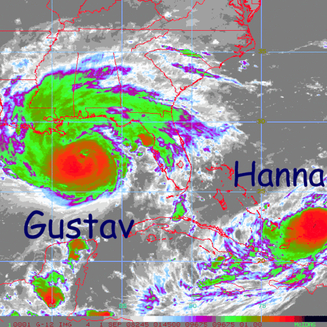
#9306 Postby HURAKAN » Sun Aug 31, 2008 9:29 pm

Image

Dangerous siblings.
0 likes   

User avatar
Downdraft
S2K Supporter
S2K Supporter
Posts: 906
Joined: Wed Oct 09, 2002 8:45 pm
Location: Sanford, Florida
Contact:

Re: Cat 3 Hurricane Gustav in Gulf of Mexico

#9307 Postby Downdraft » Sun Aug 31, 2008 9:30 pm

I think the storm is pretty steady state now till landfall.
0 likes   

Ed Mahmoud

Re: Cat 3 Hurricane Gustav in Gulf of Mexico

#9308 Postby Ed Mahmoud » Sun Aug 31, 2008 9:30 pm

MHurricanes wrote:
desertrat75 wrote:Uhh, yeah. These morons are in Houma, getting drunk and webcasting. Warning: not safe for work or children.

http://www.gregledet.net/hurricam/hurricam.html


Deseret,

It's their first time and they are excited. They won't be for long.

I have a new appreciation for the power of Mother Nature after going through Charley (and I live in Seminole County, almost 200 miles from landfall). Some of us could not navigate for days. (Only a low CAT 1, and a fast mover.)

- MHurricanes


Going for a YouTube style Darwin Award?
0 likes   

User avatar
Wthrman13
Professional-Met
Professional-Met
Posts: 502
Joined: Sun Jul 06, 2003 12:44 pm
Location: West Lafayette, IN
Contact:

Re: Re:

#9309 Postby Wthrman13 » Sun Aug 31, 2008 9:30 pm

physicx07 wrote:
RL3AO wrote:Significant Wind Levels...
Level Wind Direction Wind Speed
961mb (Surface) 50° (from the NE) 80 knots (92 mph)
959mb 45° (from the NE) 79 knots (91 mph)
955mb 45° (from the NE) 95 knots (109 mph)
949mb 50° (from the NE) 109 knots (125 mph)
943mb 60° (from the ENE) 110 knots (127 mph)
935mb 55° (from the NE) 121 knots (139 mph)
927mb 60° (from the ENE) 113 knots (130 mph)
920mb 60° (from the ENE) 115 knots (132 mph)
912mb 65° (from the ENE) 108 knots (124 mph)
893mb 70° (from the ENE) 109 knots (125 mph)
870mb 75° (from the ENE) 119 knots (137 mph)
829mb 85° (from the E) 106 knots (122 mph)
809mb 80° (from the E) 122 knots (140 mph)
751mb 105° (from the ESE) 89 knots (102 mph)

Anything unusually about the winds being that much stronger just below flight level?


I think the winds are usually supposed to be strongest around 925mb level. The FL to surface reduction value is greatest for that level (I think .75)


Yeah, if it weren't for surface friction, the strongest winds in a warm core cyclone would actually be at the surface. Friction and turbulence near the surface will reduce the winds there significantly, whereas, just above the frictional boundary layer, you would see the strongest winds. Flight level for recon is usually above that level.
0 likes   

Ed Mahmoud

Re: Cat 3 Hurricane Gustav in Gulf of Mexico

#9310 Postby Ed Mahmoud » Sun Aug 31, 2008 9:31 pm

Looks ugly coming up from Plaquemines Parish...

Image
Last edited by Ed Mahmoud on Sun Aug 31, 2008 9:33 pm, edited 1 time in total.
0 likes   

mathwhizz
Tropical Low
Tropical Low
Posts: 33
Joined: Sun Aug 17, 2008 2:13 am

#9311 Postby mathwhizz » Sun Aug 31, 2008 9:32 pm

Am I the only one seeing the NW/NNW movement on radar and satellite?

I waiting for the west bend and I don't see it yet.
0 likes   

User avatar
masaji79
Tropical Storm
Tropical Storm
Posts: 183
Joined: Sun Dec 02, 2007 12:36 am
Location: Las Vegas, Nevada

Re: Cat 3 Hurricane Gustav in Gulf of Mexico

#9312 Postby masaji79 » Sun Aug 31, 2008 9:33 pm

My eyes have been seeing the NW/NNW movement as well.
0 likes   

Derek Ortt

#9313 Postby Derek Ortt » Sun Aug 31, 2008 9:34 pm

recon reported a higher pressure this time

The intensification seems to have ended and southerly shear has returned
0 likes   

dwg71
Category 5
Category 5
Posts: 2349
Joined: Wed Jun 08, 2005 4:34 pm

#9314 Postby dwg71 » Sun Aug 31, 2008 9:34 pm

me three..on a more northerly component. One little jog north could be devastating for nola
Last edited by dwg71 on Sun Aug 31, 2008 9:35 pm, edited 1 time in total.
0 likes   

superfly

Re: Cat 3 Hurricane Gustav in Gulf of Mexico

#9315 Postby superfly » Sun Aug 31, 2008 9:35 pm

Recon only shows 95-100kts but also shows a VERY broad wind field.
0 likes   

tallywx
Category 2
Category 2
Posts: 790
Joined: Thu Jul 03, 2003 10:19 am
Location: Raleigh/Durham, NC

Re: Cat 3 Hurricane Gustav in Gulf of Mexico

#9316 Postby tallywx » Sun Aug 31, 2008 9:35 pm

masaji79 wrote:My eyes have been seeing the NW/NNW movement as well.


From the center of eye's current position, it would have to move at 305 degrees to hit at the current NHC projected landfall spot. 315 degrees takes it to Grand Isle. 320 degrees takes it over New Orleans.
0 likes   

Javlin
Category 5
Category 5
Posts: 1620
Age: 64
Joined: Fri Jul 09, 2004 7:58 pm
Location: ms gulf coast

Re:

#9317 Postby Javlin » Sun Aug 31, 2008 9:36 pm

dwg71 wrote:me three..

I am in and was about to post the same thing but opted out to see the local radar a bit longer.
0 likes   

User avatar
Normandy
Category 5
Category 5
Posts: 2293
Joined: Sun Oct 10, 2004 12:31 am
Location: Houston, TX

Re: Cat 3 Hurricane Gustav in Gulf of Mexico

#9318 Postby Normandy » Sun Aug 31, 2008 9:36 pm

Yep, convection is now consistently weakening... Good news, i thought earlier that Gustav might go nuts before landfall. Still, no need to downplay this....its gonna be awful.
0 likes   

User avatar
Enzo Aquarius
Tropical Storm
Tropical Storm
Posts: 160
Joined: Wed Jul 23, 2008 12:53 pm
Location: Canada

Re: Cat 3 Hurricane Gustav in Gulf of Mexico

#9319 Postby Enzo Aquarius » Sun Aug 31, 2008 9:37 pm

Ed Mahmoud wrote:Looks ugly coming up from Plaquemines Parish...

Image


Almost at New Orleans....
0 likes   

User avatar
ekal
Tropical Storm
Tropical Storm
Posts: 210
Age: 36
Joined: Thu Aug 25, 2005 11:13 am
Location: Miami, Florida

Re: Re:

#9320 Postby ekal » Sun Aug 31, 2008 9:37 pm

WxGuy1 wrote:
ekal wrote: I guess what I mean to ask is -- Are we in need of some better tools for detecting atmospheric water vapor content (in the layer that is meaningful for tropical cyclones)?


Some precipitable water graphics -- such as THIS ONE from DMSP SSM/I and THIS ONE from AMSU -- show some of the drier air in the western Gulf that one can see on Water Vapor satellite imagery. In addition, the 00Z soundings from this evening from places such as CRP and BRO sampled air with only ~1.35" of precipitable water, which is not particularly moist or high for a Gulf of Mexico station. LCH sampled higher precipitable water, but that's not surprising since it looks like the driest air is south of there. Of course, it's common to get subsidence and some drying on the outer edges of significant tropical cyclones, but there's some dry air there nonethless. WV imagery showed some of that drier air advected around the south then east side of the storm. In addition, visible sat data showed some signs that dry air was being advected closer to the center this afternoon, though that doesnt appear to be the case now.


Ah. The mid-levels on those soundings are extremely dry. I can understand the entrainment now.

You know, Wilma was surrounded by dry air in the Western and Northern GOM, yet it never became entrained into the inner core. I remember Derek mentioning that the effects of dry air have a lot to do with the strength of the wind shear impacting the system. Stronger shear, I think, causes the dry air to penetrate the core more effectively, as has been the case with Gustav.
0 likes   


Return to “2008”

Who is online

Users browsing this forum: No registered users and 8 guests