
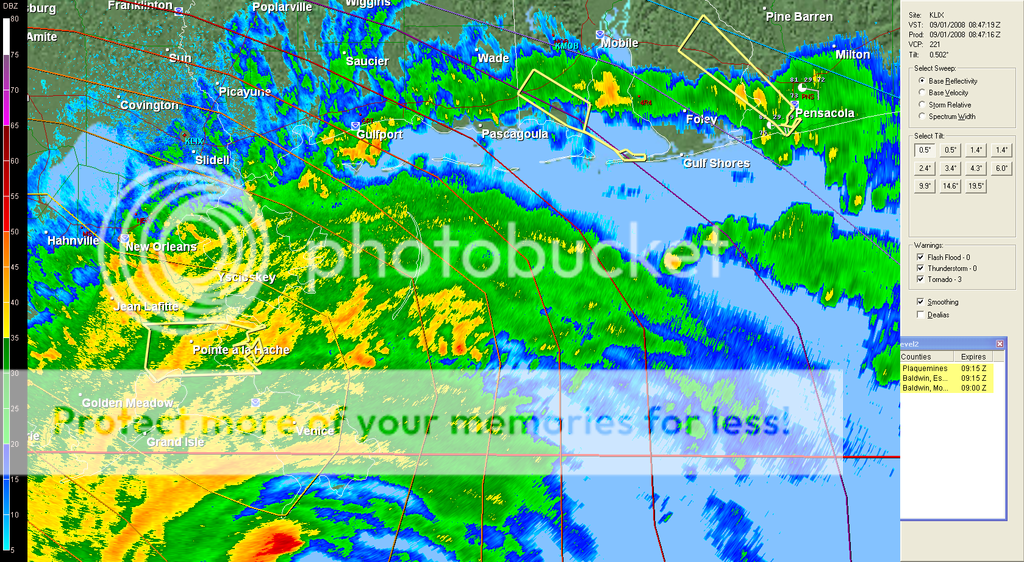
I don't know what happened but the little eye collapsed and there's now a gigantic semi-circular area of no precipitation. Is this the new bigger eye?
http://radar.weather.gov/radar.php?prod ... X&loop=yes
ATL GUSTAV: Tropical Depression - Discussion
Moderator: S2k Moderators
-
Stormcenter
- S2K Supporter

- Posts: 6685
- Joined: Wed Sep 03, 2003 11:27 am
- Location: Houston, TX
Re:
mathwhizz wrote:I don't know what happened but the little eye collapsed and there's now a gigantic semi-circular area of no precipitation. Is this the new bigger eye?
http://radar.weather.gov/radar.php?prod ... X&loop=yes
Look closely you can see the eye rotate quickly.
0 likes
Re: Cat 3 Hurricane Gustav in Gulf of Mexico
thing is those observations at SW pass are inflated and not surface measurements
that are about 100 feet or so in elevation, still impressive but not as indicative of surface winds IMO
max fl winds are 101 in ne quad, so not really fitting cat 3 based on latest wind data IMO
that are about 100 feet or so in elevation, still impressive but not as indicative of surface winds IMO
max fl winds are 101 in ne quad, so not really fitting cat 3 based on latest wind data IMO
0 likes


Re:
Stormcenter wrote:Current conditions. I don't understand the "fog" in Boothville.
I think it must heavy rain.Anyway check out pressure readings.
N.O. INTL ARPT CLOUDY 80 74 81 NE25G37 29.56F
N.O. LAKEFRONT CLOUDY 80 72 76 NE39G49 29.54F
SLIDELL CLOUDY 79 72 79 NE15G24 29.60F
BELLE CHASSE LGT RAIN 78 73 84 NE17G31 29.53F
BATON ROUGE CLOUDY 77 71 82 N9 29.67F
SALT POINT N/A 75 71 87 N9G17 29.61F
BOOTHVILLE HVY RAIN 79 76 90 NE44G61 29.34F FOG
The fog is because vis is low in the heavy rain. It's an ASOS automated thing.
Last edited by physicx07 on Mon Sep 01, 2008 3:45 am, edited 1 time in total.
0 likes
-
Janie2006

- Category 5

- Posts: 1329
- Joined: Mon Sep 18, 2006 3:28 pm
- Location: coastal Ms aka home of the hurricanes
Things are really starting to pop around here in Mobile County (yes, I know what my location says!) This particular feeder band has quite a lot of tornadic activity associated with it, from southern Mobile County over into Escambia County, Florida. Some of the individual cells are moving NW at 64 mph.
Edited to add: WKRG reports that the Hurricane Warning for Mobile and Baldwin Counties has been dropped and replaced with a Tropical Storm Warning.
Edited to add: WKRG reports that the Hurricane Warning for Mobile and Baldwin Counties has been dropped and replaced with a Tropical Storm Warning.
0 likes

Re: Cat 3 Hurricane Gustav in Gulf of Mexico
Not too many folks are concerned with Stake Island off of the coast of Louisiana....it has zero population. Grand Isle is the only inhabited island on Louisiana’s gulf coast.
I know you are just using if for reference but I just wanted everyone to know that no one lives there.
Conditions will be terrible all around there but thankfully Stake Island is one of the many islands off of the coast of LA that is not inhabited.
I know you are just using if for reference but I just wanted everyone to know that no one lives there.
Conditions will be terrible all around there but thankfully Stake Island is one of the many islands off of the coast of LA that is not inhabited.
0 likes
-
boogiefrizz

- S2K Supporter
- Posts: 8
- Age: 50
- Joined: Tue Jul 01, 2008 11:26 am
Re:
Janie2006 wrote:Things are really starting to pop around here in Mobile County (yes, I know what my location says!) This particular feeder band has quite a lot of tornadic activity associated with it, from southern Mobile County over into Escambia County, Florida. Some of the individual cells are moving NW at 64 mph.
Oh yes, really starting to feel it here in Pcola. Winds picking up and rumbles of thunder in the distance. Looks like some nastiness coming from the south shortly. Currently under tornado warning.
0 likes

Re:
KWT wrote:Yep it does seem to be moving at a pretty good clip now, the SW pass should indeed get the NE eyewall within the next hour, they will no doubt get cat-2/3 type winds in that tip, conditions there right now must be unreal, surge should be pilling rioght across the SE tip now.
Check this out for Sw pass. The weater level rising much above predicted level. http://tidesonline.nos.noaa.gov/plotcom ... Pass,+LA+#
0 likes
Re: Re:
ugaap wrote:KWT wrote:Yep it does seem to be moving at a pretty good clip now, the SW pass should indeed get the NE eyewall within the next hour, they will no doubt get cat-2/3 type winds in that tip, conditions there right now must be unreal, surge should be pilling rioght across the SE tip now.
Check this out for Sw pass. The weater level rising much above predicted level. http://tidesonline.nos.noaa.gov/plotcom ... Pass,+LA+#
before anyone gets alarmed, those predictions were before a storm was forecast
those "predicted levels" match the normal everyday swing of high tide to low tide. and they are relatively the same for the whole gulf coast region
0 likes
-
jlauderdal
- S2K Supporter
- Posts: 7240
- Joined: Wed May 19, 2004 5:46 am
- Location: NE Fort Lauderdale
- Contact:
Re: Cat 3 Hurricane Gustav in Gulf of Mexico
Newest Advisory just came out.
Hurricane GUSTAV Public Advisory
000
WTNT32 KNHC 010842
TCPAT2
BULLETIN
HURRICANE GUSTAV ADVISORY NUMBER 31
NWS TPC/NATIONAL HURRICANE CENTER MIAMI FL AL072008
400 AM CDT MON SEP 01 2008
...GUSTAV NEARING THE LOUISIANA COAST...HEAVY RAIN BANDS APPROACHING
NEW ORLEANS...
AT 4 AM CDT...0900 UTC...THE HURRICANE WARNING EAST OF THE
MISSISSIPPI-ALABAMA BORDER TO THE ALABAMA-FLORIDA BORDER HAS BEEN
CHANGED TO A TROPICAL STORM WARNING. A HURRICANE WARNING REMAINS
IN EFFECT FROM JUST EAST OF HIGH ISLAND TEXAS EASTWARD TO THE
MISSISSIPPI-ALABAMA BORDER...INCLUDING THE CITY OF NEW ORLEANS AND
LAKE PONTCHARTRAIN. PREPARATIONS TO PROTECT LIFE AND PROPERTY
SHOULD HAVE BEEN COMPLETED.
A TROPICAL STORM WARNING IS IN EFFECT FROM EAST OF THE
MISSISSIPPI-ALABAMA BORDER TO THE OCHLOCKONEE RIVER.
FOR STORM INFORMATION SPECIFIC TO YOUR AREA...INCLUDING POSSIBLE
INLAND WATCHES AND WARNINGS...PLEASE MONITOR PRODUCTS ISSUED
BY YOUR LOCAL WEATHER OFFICE.
AT 400 AM CDT...0900Z...THE CENTER OF HURRICANE GUSTAV WAS LOCATED
NEAR LATITUDE 28.4 NORTH...LONGITUDE 89.5 WEST OR ABOUT 115 MILES...
185 KM...SOUTH-SOUTHEAST OF NEW ORLEANS LOUISIANA AND ABOUT 195
MILES...315 KM...SOUTHEAST OF LAFAYETTE LOUISIANA. THIS POSITION IS
ALSO ABOUT 65 MILES...105 KM...SOUTHEAST OF PORT FOURCHON ALONG THE
LOUISIANA COAST.
GUSTAV IS MOVING TOWARD THE NORTHWEST NEAR 16 MPH...26 KM/HR...AND
THIS MOTION IS EXPECTED TO CONTINUE FOR THE NEXT DAY OR SO WITH SOME
DECREASE IN FORWARD SPEED AND A GRADUAL TURN TOWARD THE WEST-
NORTHWEST ON TUESDAY. ON THE FORECAST TRACK...THE CENTER WILL
CROSS THE LOUISIANA COAST BY MIDDAY TODAY.
MAXIMUM SUSTAINED WINDS ARE NEAR 115 MPH...185 KM/HR...WITH HIGHER
GUSTS. GUSTAV IS A CATEGORY THREE HURRICANE ON THE SAFFIR-SIMPSON
SCALE. NO SIGNIFICANT CHANGE IN STRENGTH IS LIKELY BEFORE
LANDFALL...WITH WEAKENING EXPECTED TO BEGIN AFTER GUSTAV MOVES
INLAND LATER TODAY.
HURRICANE FORCE WINDS EXTEND OUTWARD UP TO 70 MILES...110 KM...FROM
THE CENTER...AND TROPICAL STORM FORCE WINDS EXTEND OUTWARD UP TO 230
MILES...370 KM. BOOTHVILLE LOUISIANA REPORTED A WIND GUST TO 70
MPH...113 KM/HR...AND A STATION AT SOUTHWEST PASS LOUISIANA
REPORTED SUSTAINED WINDS OF 76 MPH...122 KM/HR WITH A GUST OF 108
MPH...174 KM/HR AT AN ELEVATION OF 79 FEET ABOVE SEA LEVEL.
AN AIR FORCE HURRICANE HUNTER AIRCRAFT REPORTED A MINIMUM CENTRAL
PRESSURE OF 956 MB...28.23 INCHES.
AN EXTREMELY DANGEROUS STORM SURGE OF 10 TO 14 FEET ABOVE NORMAL
TIDAL LEVELS IS EXPECTED NEAR AND TO THE EAST OF WHERE THE CENTER
OF GUSTAV CROSSES THE COAST.
GUSTAV IS EXPECTED TO PRODUCE TOTAL RAINFALL ACCUMULATIONS OF 6 TO
12 INCHES OVER PORTIONS OF LOUISIANA...SOUTHERN AND WESTERN
MISSISSIPPI...ARKANSAS AND NORTHEASTERN TEXAS...WITH ISOLATED
MAXIMUM AMOUNTS OF UP TO 20 INCHES POSSIBLE THROUGH THURSDAY.
ISOLATED TORNADOES ARE POSSIBLE OVER THE CENTRAL GULF COAST TODAY.
REPEATING THE 400 AM CDT POSITION...28.4 N...89.5 W. MOVEMENT
TOWARD...NORTHWEST NEAR 16 MPH. MAXIMUM SUSTAINED WINDS...115 MPH.
MINIMUM CENTRAL PRESSURE...956 MB.
INTERMEDIATE ADVISORIES WILL BE ISSUED BY THE NATIONAL HURRICANE
CENTER AT 600 AM CDT AND 800 AM CDT FOLLOWED BY THE NEXT COMPLETE
ADVISORY AT 1000 AM CDT.
$$
FORECASTER PASCH/BERG
0 likes

Re: Cat 3 Hurricane Gustav in Gulf of Mexico
Has anyone gotten the Boothville ASOS report that should have come out 10-15 mins. ago? My link through the NWS isn't updated as though it may have gone down.
0 likes
-
Matt-hurricanewatcher
Re: Cat 3 Hurricane Gustav in Gulf of Mexico
This is NOT a Cat3. Recon data with 101 knots over the notheast quad supports about 90 knots at 700 millibars flight level that is .9 of that. This is a moderate cat2...
0 likes
-
JonathanBelles
- Professional-Met

- Posts: 11430
- Age: 35
- Joined: Sat Dec 24, 2005 9:00 pm
- Location: School: Florida State University (Tallahassee, FL) Home: St. Petersburg, Florida
- Contact:


Re:
KWT wrote:Maybe Matt but either way its offically by the NHC going to come in as a 3. I think the way recentrly the structure is coming undone somewhat as it gets close to land probably does suggest that Gus is below 3 strength but the NHC guidence is what matters.
The NHC admits in their discussion that 100kts is generous. There was dropsonde earlier this morning that showed surface winds at 100kts, but the pressure has risen since then and the eye has fallen apart. So I think it may below Cat 3 now.
0 likes
Who is online
Users browsing this forum: No registered users and 69 guests