This system looks like a 70 knot cat1 to me based on IR. In fact, I doubt it would even be a cane if this was at 15 north/30 west. Why you ask, microwave data would only show that it has part of a eye, in which would tell the nhc that this should be at least 50-55 knots. In which case the nhc would likely make it around that. They would be forecasting this to become one if the environment was favorable enough.
Do you agree or disagree with this?
ATL GUSTAV: Tropical Depression - Discussion
Moderator: S2k Moderators

Re: Cat 3 Hurricane Gustav in Gulf of Mexico
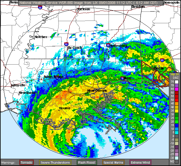
Wow, at this moment there appear to be 8 or 9 radar detected tornadoes mostly in the FL panhandle and Alabama, and one in Louisiana.
Also on radar, looks like it's still a tad offshore. I know this is looking a little higher up, but if the system is stacked like it should be for a cat 2, then it shouldn't be a big issue.
Also on radar, looks like it's still a tad offshore. I know this is looking a little higher up, but if the system is stacked like it should be for a cat 2, then it shouldn't be a big issue.
0 likes


Re: Cat 3 Hurricane Gustav in Gulf of Mexico
Matt-hurricanewatcher wrote:This system looks like a 70 knot cat1 to me based on IR. In fact, I doubt it would even be a cane if this was at 15 north/30 west. Why you ask, microwave data would only show that it has part of a eye, in which would tell the nhc that this should be at least 50-55 knots. In which case the nhc would likely make it around that. They would be forecasting this to become one if the environment was favorable enough.
Do you agree or disagree with this?
Pressures from recon support a storm far stronger than 70 kt.
0 likes

-
Matt-hurricanewatcher
Re: Cat 3 Hurricane Gustav in Gulf of Mexico
Chacor wrote:Matt-hurricanewatcher wrote:This system looks like a 70 knot cat1 to me based on IR. In fact, I doubt it would even be a cane if this was at 15 north/30 west. Why you ask, microwave data would only show that it has part of a eye, in which would tell the nhc that this should be at least 50-55 knots. In which case the nhc would likely make it around that. They would be forecasting this to become one if the environment was favorable enough.
Do you agree or disagree with this?
Pressures from recon support a storm far stronger than 70 kt.
I'm saying if it was not for the recon, and this storm was out in the middle of the Atlatnic. This goes to show that looks are not everything.
0 likes
-
USTropics
- Professional-Met

- Posts: 2734
- Joined: Sun Aug 12, 2007 3:45 am
- Location: Florida State University
Re:
KWT wrote:Yep sure looks like it on radar now, should get offical word through on a landfall pretty soon I'd have thought.
I believe it is an official landfall when the entire eye has come ashore. Looking at KLIX radar, the northern portion is just now making landfall.

0 likes
No Matt Dvorak numbers also support way higher then 70kts right now as well.
The other threat further out from the inner core in the more outer bands has to be tornadoes, its producing a fair few and these are rain wrapped which makes them tough to see.
ustropics, yeah te northern part of the eye onshore now but the center isn't just there yet.
The other threat further out from the inner core in the more outer bands has to be tornadoes, its producing a fair few and these are rain wrapped which makes them tough to see.
ustropics, yeah te northern part of the eye onshore now but the center isn't just there yet.
Last edited by KWT on Mon Sep 01, 2008 7:43 am, edited 1 time in total.
0 likes


-
Matt-hurricanewatcher
Re: Cat 3 Hurricane Gustav in Gulf of Mexico
This thing appears to be going west-northwest or even west. I would say 285-295 degree's right now...If it can make it another .5 of a degree westward it will earn its self another 3-4 hours over water as the shoreline slope northward after that.
0 likes
Re:
Chacor wrote:Remember it's not always the centre of the eye — it has to be the centre of circulation, which isn't necessarily stacked with the centre of the eye, that crosses land to count as landfall.
Just to prove my point, this came out at the right time...
URNT12 KNHC 011247
VORTEX DATA MESSAGE AL072008
A. 01/12:30:20Z
B. 28 deg 49 min N
090 deg 24 min W
C. 700 mb 2734 m
D. 74 kt
E. 272 deg 17 nm
F. 002 deg 081 kt
G. 271 deg 044 nm
H. 957 mb
I. NA C/ 3042 m
J. 16 C/ 3044 m
K. 14 C/ NA
L. CLOSED WALL
M. C30
N. 12345/7
O. 0.02 / 2 nm
P. AF307 2807A GUSTAV OB 12
MAX FL WIND 91 KT NW QUAD 11:45:00 Z
MAX OUTBOUND FL WIND 90 KT E QUAD 12:36:30Z
MULTIPLE SMALL BREAKS IN WALL CLOUD
UNABLE TO FIX SFC CNTR
The IR/visible eye doesn't always stack with the surface centre.
0 likes
Re: Re:
Chacor wrote:Chacor wrote:Remember it's not always the centre of the eye — it has to be the centre of circulation, which isn't necessarily stacked with the centre of the eye, that crosses land to count as landfall.
Just to prove my point, this came out at the right time...
URNT12 KNHC 011247
VORTEX DATA MESSAGE AL072008
A. 01/12:30:20Z
B. 28 deg 49 min N
090 deg 24 min W
C. 700 mb 2734 m
D. 74 kt
E. 272 deg 17 nm
F. 002 deg 081 kt
G. 271 deg 044 nm
H. 957 mb
I. NA C/ 3042 m
J. 16 C/ 3044 m
K. 14 C/ NA
L. CLOSED WALL
M. C30
N. 12345/7
O. 0.02 / 2 nm
P. AF307 2807A GUSTAV OB 12
MAX FL WIND 91 KT NW QUAD 11:45:00 Z
MAX OUTBOUND FL WIND 90 KT E QUAD 12:36:30Z
MULTIPLE SMALL BREAKS IN WALL CLOUD
UNABLE TO FIX SFC CNTR
The IR/visible eye doesn't always stack with the surface centre.
I don't think you can reliably see the eye in IR. It's been partially to mostly filled all day. So if you can't locate it at the surface, however they tried, then what else can you use but radar?
0 likes
Re: Re:
physicx07 wrote:Chacor wrote:Chacor wrote:Remember it's not always the centre of the eye — it has to be the centre of circulation, which isn't necessarily stacked with the centre of the eye, that crosses land to count as landfall.
Just to prove my point, this came out at the right time...
URNT12 KNHC 011247
VORTEX DATA MESSAGE AL072008
A. 01/12:30:20Z
B. 28 deg 49 min N
090 deg 24 min W
C. 700 mb 2734 m
D. 74 kt
E. 272 deg 17 nm
F. 002 deg 081 kt
G. 271 deg 044 nm
H. 957 mb
I. NA C/ 3042 m
J. 16 C/ 3044 m
K. 14 C/ NA
L. CLOSED WALL
M. C30
N. 12345/7
O. 0.02 / 2 nm
P. AF307 2807A GUSTAV OB 12
MAX FL WIND 91 KT NW QUAD 11:45:00 Z
MAX OUTBOUND FL WIND 90 KT E QUAD 12:36:30Z
MULTIPLE SMALL BREAKS IN WALL CLOUD
UNABLE TO FIX SFC CNTR
The IR/visible eye doesn't always stack with the surface centre.
I don't think you can reliably see the eye in IR. It's been partially to mostly filled all day. So if you can't locate it at the surface, however they tried, then what else can you use but radar?
Well, they found an eye (L. CLOSED WALL; M. C30) or at least an eyewall, but it's apparently not the centre.
0 likes
-
Mattie

- S2K Supporter

- Posts: 583
- Joined: Thu Sep 11, 2003 7:44 pm
- Location: North Texas (formerly South Louisiana)
- Contact:
Re: Cat 3 Hurricane Gustav in Gulf of Mexico
Just hear that the eyewall is regenerating and hugging the coast - comments?
0 likes
-
BigB0882
- S2K Supporter
- Posts: 2289
- Joined: Thu Jul 03, 2003 12:08 am
- Location: Baton Rouge, LA
- Contact:
Waiting here in Baton Rouge, lights flickered but came back, thank goodness. Looks like some of the heavier rain about to move in but we have had hardly anything yet in the way of rain or wind. I guess it will come later but it is looking like we dodged a bullet. I am not sure this is at all a 115 mph hurricane right now.
0 likes
Who is online
Users browsing this forum: No registered users and 16 guests