jlauderdal wrote:
the theory is you want to be at the 5 day point because of NHC's error forecasting that far out, you have to agree there is some merit to the thought of it. Of course you have gustav where that idea didnt workout so well.
ATL: IKE Discussion
Moderator: S2k Moderators
Re: Re:
so is it also advantageous for the keys to be at the 4-day point now, since that far out has a large margin of error as well?
0 likes

Re: ATL IKE: Category 3 - Discussion
After further review of almost all the posts I've been reading lately, I've decided to show you all my very own weather forecating model.
[img=http://img247.imageshack.us/img247/5753/sidewalktennismx1.th.gif]
[img=http://img247.imageshack.us/img247/5753/sidewalktennismx1.th.gif]
Last edited by StJoe on Fri Sep 05, 2008 4:35 pm, edited 2 times in total.
0 likes
-
Weatherfreak000
-
jlauderdal
- S2K Supporter

- Posts: 7240
- Joined: Wed May 19, 2004 5:46 am
- Location: NE Fort Lauderdale
- Contact:
Re:
WhirlWind wrote:This was just posted on a live chat with Dr. Jeff Masters on the newspress.com
JeffMasters - Everyone one the West Coast of Florida should be concerned about Ike. It sould hit anywhere along the coast as a Category 3 or 4 hurricane. There's a very good chance it will "shoot the gap" between Cuba and S. Florida and hook around and hit you. However, if you do live in W. Florida, there is no need to pack your bags yet. The forecast still has a high amount of uncertainty, and I wouldn't be surprised to see the model runs converge on a solution tomorrow that shows less danger for W. Florida.
Just a FYI
WhirlWind
masters is set, he says there's a very good chance it will hook around and hit west coast then he says he wouldnt be surprised if the models converge showing less danger for west coast. Good news, his idea has already verified no matter what happens.
0 likes
Re:
104.7 miles plus or minus 200 miles or so....
HURAKAN wrote:Results for 25.7N, 80.4W:
The approximate Closest Point of Approach (CPA) is located near 24.3N, 81.1W or about 104.7 miles (168.5 km) from your location. The estimated time of when the center of the storm will be at that location is in about 93.5 hours (Tuesday, September 9 at 2:30PM EDT).
Link: http://stormcarib.com/closest.cgi
0 likes
-
SouthFLTropics

- Category 5

- Posts: 4258
- Age: 50
- Joined: Thu Aug 14, 2003 8:04 am
- Location: Port St. Lucie, Florida
Re: ATL IKE: Category 3 - Discussion
meteorologyman wrote:regaurdles where this go,Everyone in Florida needs to be prepared, because one way or another majority of Fl if not all FL will be impacted unless it decides to recurve bact to sea which is looking very unlikely,FL will either get slammed with heavy rain, or Heavy wind, or even both. The beach cost will take a heavy beating with erosion,
If it comes from the west side (the GULF) the SE FL, Keys, W coast FL, centralFL, l E centralFL, NE FL will get impacted.
IF it hits the east side of FL: SE FL, Central FL, E central FL, W FL, and NE FL will get impacted
And option three...If it runs up the middle then we all get impacted!!!
SFT
0 likes


-
jlauderdal
- S2K Supporter
- Posts: 7240
- Joined: Wed May 19, 2004 5:46 am
- Location: NE Fort Lauderdale
- Contact:
Re:
WhirlWind wrote:ok more live chat from Dr. Jeff Masters
JeffMasters - Ike could cross the state from Miami to Ft. Myers, emerge into the Gulf, then turn around and hit Tampa and cross the state again. That is the current GFS model forecast.
WhirlWind
ok so now he has said west coast hook likely, model convergence with no west coast wouldnt be surprise, track from miami to fort myers then back to tampa....the only thing we havent hit yet is key west, jacksonville and pensacola
0 likes

Re: ATL IKE: Category 3 - Discussion
Myersgirl wrote:My SW FLA friends, did anyone see ch 5 Jim Farrell explain how the high moving in over the mid west would prevent Ike from coming back east should it end up offshore of SW FlA???
bump... first I have heard of this mid west high that would not allow Ike to turn back toward Florida once in Gulf
0 likes
Re: ATL IKE: Category 3 - Discussion
The reality is that the track really doens't have to shift north for south florida to likely go under a hurricane watch in a few days....given the margin of error that we may see even sunday.
now if the track shifts 150 miles south, that is a different story. But as long as we are well within the cone, the margin of error for a potential monster is too risky....what if there is a 50-mile shift north on monday afternoon and south florida has not prepared. by then it is almost too late.
South Florida was under a hurricane warning for Floyd...and that was with strong support for a turn east of florida. As opposed to being on the dry side, South Florida is likely to be on the dirty side now as well.
Canelaw99 wrote:jinftl wrote:Canelaw, why would saying that SFL is not out of the woods be going against the NHC??? Where has the NHC said that? Does the cone reflect that as of 5pm? The probability of 34kt winds in Miami is higher than any other location (tied with Marathon).
What happens if tomorrow a model shifts east...folks will be shocked but a 50-mile shift in either direction for a storm 1000 miles away can't be viewed as an all-clear.
My point was with jlaud's post about how Max seems when he's talking on Channel 10. It seems that he's holding something back, and I'm simply guessing at what it is. It also wouldn't be very good for him to turn around on air and say "All Hell's going to break loose in downtown Miami tues. Run while you can." I mean, that's an exaggeration, but that's the kind of thing I was referring to. If he has the thoughts/feelings/ideas/whatever that this is shifting north and will impact more of metro Dade or Broward, it wouldn't be good for him to come out and say it when the NHC track has shifted to the lower Keys and they mentioned it could shift further south and west in their 5pm disco.
People here in S FL will continue to prep as long as the threat is still there, but as soon as it seems the threat has shifted far enough off of us, most preps will slow or cease, as mentioned in an earlier post.....
Did that come across better?
0 likes
Re: ATL IKE: Category 3 - Discussion
StJoe wrote:After further review of almost all the posts I've been reading lately, I've decided to show you all my very own weather forecating model.
[img=http://img247.imageshack.us/img247/5753/sidewalktennismx1.th.gif]
0 likes
-
nolecaster
- Tropical Depression

- Posts: 52
- Joined: Tue Aug 31, 2004 7:15 pm
- Location: Tallahassee
- Contact:
Re: ATL IKE: Category 3 - Discussion
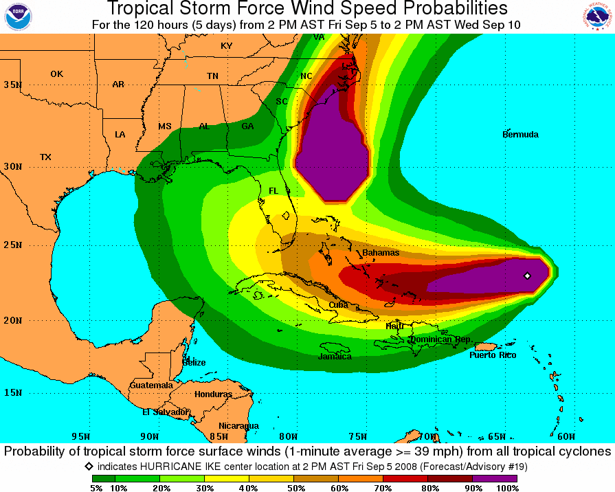
jinftl wrote:Did anyone notice that the radius of tropical storm force winds went from 105 miles from the center at 11am to 120 miles at 5pm? The radius of hurricane force winds went from 35 miles from the center at 11am to 45 miles at 5pm as well.
Expanding wind field....hmmmm....impacts potentially further from center....hmmm...
Wind field @11am - no recon
Wind field @5pm - with recon
I'm assuming they have a better handle on the wind field now just because of the recon. Lets see if it expands again in the next few advisories.
0 likes
-
jlauderdal
- S2K Supporter
- Posts: 7240
- Joined: Wed May 19, 2004 5:46 am
- Location: NE Fort Lauderdale
- Contact:
Re: Re:
jinftl wrote:so is it also advantageous for the keys to be at the 4-day point now, since that far out has a large margin of error as well?jlauderdal wrote:
the theory is you want to be at the 5 day point because of NHC's error forecasting that far out, you have to agree there is some merit to the thought of it. Of course you have gustav where that idea didnt workout so well.
nope, you need to pick the spot in the keys at the 4 day point not the whole keys, the island chain is rather large...however at 4 days you are more likely to get hit and so on and so on due to the track error decreasing.
0 likes
-
CourierPR

- Category 5
- Posts: 1336
- Age: 72
- Joined: Tue Aug 31, 2004 7:53 pm
- Location: Pompano Beach, Florida
Re: ATL IKE: Category 3 - Discussion
Myersgirl wrote:Myersgirl wrote:My SW FLA friends, did anyone see ch 5 Jim Farrell explain how the high moving in over the mid west would prevent Ike from coming back east should it end up offshore of SW FlA???
bump... first I have heard of this mid west high that would not allow Ike to turn back toward Florida once in Gulf
I believe Max Mayfield said that a weakness is forecast to develop. The only question is when and where.
0 likes
Re: ATL IKE: Category 3 - Discussion
Larger wind field than previously thought. That is potentially 20 more miles of land that will experience hurricane force winds....that could be significant as far as damage potentially...and just as important...in the NHC's determination where to place hurricane watches/warnings and ts watches/warnings.
nolecaster wrote:jinftl wrote:Did anyone notice that the radius of tropical storm force winds went from 105 miles from the center at 11am to 120 miles at 5pm? The radius of hurricane force winds went from 35 miles from the center at 11am to 45 miles at 5pm as well.
Expanding wind field....hmmmm....impacts potentially further from center....hmmm...
Wind field @11am - no recon
Wind field @5pm - with recon
I'm assuming they have a better handle on the wind field now just because of the recon. Lets see if it expands again in the next few advisories.
0 likes
-
jlauderdal
- S2K Supporter
- Posts: 7240
- Joined: Wed May 19, 2004 5:46 am
- Location: NE Fort Lauderdale
- Contact:
Re: ATL IKE: Category 3 - Discussion
CourierPR wrote:Myersgirl wrote:Myersgirl wrote:My SW FLA friends, did anyone see ch 5 Jim Farrell explain how the high moving in over the mid west would prevent Ike from coming back east should it end up offshore of SW FlA???
bump... first I have heard of this mid west high that would not allow Ike to turn back toward Florida once in Gulf
I believe Max Mayfield said that a weakness is forecast to develop. The only question is when and where.
correct
0 likes
-
Canelaw99

- S2K Supporter
- Posts: 2128
- Age: 49
- Joined: Tue Aug 31, 2004 8:27 am
- Location: Homestead, FL
Re: ATL IKE: Category 3 - Discussion
jinftl wrote:The reality is that the track really doens't have to shift north for south florida to likely go under a hurricane watch in a few days....given the margin of error that we may see even sunday.
now if the track shifts 150 miles south, that is a different story. But as long as we are well within the cone, the margin of error for a potential monster is too risky....what if there is a 50-mile shift north on monday afternoon and south florida has not prepared. by then it is almost too late.
South Florida was under a hurricane warning for Floyd...and that was with strong support for a turn east of florida. As opposed to being on the dry side, South Florida is likely to be on the dirty side now as well.
I agree. With the wind field the way it is and the current track, Miami Dade and most of Broward will get tropical storm force winds, at minimum. Some of southern dade could even be looking at hurricane force winds, depending on what the winds are and where it comes in. It's just unfortunate that so many people continue to rely on the skinny black line and figure they're more in the clear. I don't see that happening yet, at least not down here in Dade, but I would bet it's happening further up the FL east coase, say Palm Beach & north.....
0 likes

![[img=http://img247.imageshack.us/img247/5753/sidewalktennismx1.th.gif]](http://img247.imageshack.us/my.php?image=sidewalktennismx1.gif)
The problem is now some model aren't developing enough of a weakness to lift out Ike, like the ECM and the UKMO, so its not so much a question of when the trough lifts out Ike but possibly is this one strong enough to do the job, if its not then the threat shifts way to the west, for now most models suggest the weakness will be strong enough but its hard to know.
Hurakan, yep Ike certainly does see to be steadily reorganising once again.
Hurakan, yep Ike certainly does see to be steadily reorganising once again.
Last edited by KWT on Fri Sep 05, 2008 4:46 pm, edited 1 time in total.
0 likes
Who is online
Users browsing this forum: No registered users and 42 guests