
The Turks and Caicos are gonna take a 100-115 kt storm over the heads during the middle of the night. ...low lying limestone islands with 10+ feet storm surge possible....and the islands already saturated/flooded from Hannah.
That is ugly.
ATL: IKE Discussion
Moderator: S2k Moderators

That sure is terrible sounding hiflyer, esp givne the recent reorganisation trend we are seeing with Ike.
Also somewhere in eastern Cuba it seems is going to get totally hammered by IKe, at what strength is uncertain but I could well imagine a powerful cat-4 possibly...
jlauderdal, clearly its going to be a tough match
Also somewhere in eastern Cuba it seems is going to get totally hammered by IKe, at what strength is uncertain but I could well imagine a powerful cat-4 possibly...
jlauderdal, clearly its going to be a tough match
0 likes
-
Trader Ron

- S2K Supporter

- Posts: 928
- Joined: Tue Jul 22, 2003 7:25 pm
- Location: Naples,Fl
- Contact:
-
Meso

- Category 5

- Posts: 1609
- Age: 39
- Joined: Mon Aug 09, 2004 12:14 pm
- Location: South Africa
- Contact:
Looking at the loop it appears Ike is growing in size of late, and outflow is improving on the northern side of the storm. You can also see the shear lessening to the north of Ike. The deeper convection is looking pretty good now compared to 6 hours ago, when the system was visibly sheared. It also has made a more of a steady west movement as opposed the SW one it had earlier on. Maybe just a wobble but heading more West over the past few hours than WSW (Although it appears that the latest frame may be slightly more WSW again... probably just wobbles..)
0 likes
-
Trader Ron
- S2K Supporter
- Posts: 928
- Joined: Tue Jul 22, 2003 7:25 pm
- Location: Naples,Fl
- Contact:
Re: Re:
jlauderdal wrote:KWT wrote:It does look like Ike is getting in better shape again and maybe strengthening.
Landfall on Cuba is looking pretty severe and the T&C and islands around it are still likely to get a big blow, indeed if the NHC track holds they will now be in the stronger northern quadrant.
hey mate, its early and im going off topic...who wins england or andorra, should be a tough match
Come on JL. You know the only "true" football is played in the U.S.A.
You bringing your power cord back today?
Go Irish !
0 likes
-
jlauderdal
- S2K Supporter
- Posts: 7240
- Joined: Wed May 19, 2004 5:46 am
- Location: NE Fort Lauderdale
- Contact:
Re:
Trader Ron wrote:Stick with the GFDL/HWRF. I said it Thursday.
The Ridge has been a monster. I should have seen that. Grrrr...
TR,
be happy that ridge is in place even if your forecast busted, everyone including nhc busted from a few days ago..we didnt want this thing near us
0 likes
It seems to me Meso Ike is undertaking classic stair stepping, it went due west for about 3hrs last then took that dive nearly SW, though I do wonder whether the shear also player a role?
I still see a 260-265 motion however.
Looks like Grand Inagua island is going to take a near direct hit and then onto uba where its wind field will no doubt expand quite a lot and I Guess unless it touches Caribbean waters it'll be lucky to make it out as a 2...
I still see a 260-265 motion however.
Looks like Grand Inagua island is going to take a near direct hit and then onto uba where its wind field will no doubt expand quite a lot and I Guess unless it touches Caribbean waters it'll be lucky to make it out as a 2...
0 likes
-
Trader Ron
- S2K Supporter
- Posts: 928
- Joined: Tue Jul 22, 2003 7:25 pm
- Location: Naples,Fl
- Contact:
Re: Re:
jlauderdal wrote:Trader Ron wrote:Stick with the GFDL/HWRF. I said it Thursday.
The Ridge has been a monster. I should have seen that. Grrrr...
TR,
be happy that ridge is in place even if your forecast busted, everyone including nhc busted from a few days ago..we didnt want this thing near us
Oh...I'm dancing in the streets. And I can't dance.
We could still get some snotty weather on The W.C. if Ike doesn't get beaten up over Cuba. Especially The Keys.
0 likes
-
HURAKAN

- Professional-Met

- Posts: 46084
- Age: 39
- Joined: Thu May 20, 2004 4:34 pm
- Location: Key West, FL
- Contact:
I just want our members and guests to know that there is still a large room for error and even though the cone may be shifting south, it could easily come back up. Until the information to be gathered today, I believe, by the NOAA RECON plane about Ike's surroundings is not digested by the computer models, these models are just guessing the intensity of the ridge.
If the current model forecast holds after this information is gathered and digested, then you can be more certain about Ike's future path.
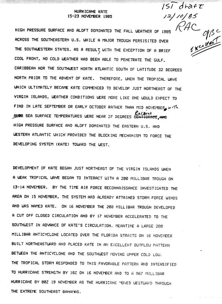
By the way, what about Hurricane Kate's path:

If the current model forecast holds after this information is gathered and digested, then you can be more certain about Ike's future path.
By the way, what about Hurricane Kate's path:
0 likes
-
attallaman
Re:
That'll work for me because I certainly don't want Ike to head my way. Gustav came pretty close to my neck of the woods earlier this week. I like having my A.C.HURAKAN wrote:I just want our members and guests to know that there is still a large room for error and even though the cone may be shifting south, it could easily come back up. Until the information to be gathered today, I believe, by the NOAA RECON plane about Ike's surroundings is not digested by the computer models, these models are just guessing the intensity of the ridge.
If the current model forecast holds after this information is gathered and digested, then you can be more certain about Ike's future path.
By the way, what about Hurricane Kate's path:
0 likes
Yeah still time for change, plenty of stuff can happen and the models could yet swing back the other way though it is looking increasingly likely Ike will give a major blow to Cuba.
A Kate situation whilst possible isn't likely really Hurakan, look at the date, that happened in November, the odds of getting a November like trough down that far south in early September aren't very high.
I think the keys are the ones that have to really pay most attention as any shift would bring them right back into play again.
0 likes

-
HURAKAN
- Professional-Met
- Posts: 46084
- Age: 39
- Joined: Thu May 20, 2004 4:34 pm
- Location: Key West, FL
- Contact:
Re:
KWT wrote:A Kate situation whilst possible isn't likely really Hurakan, look at the date, that happened in November, the odds of getting a November like trough down that far south in early September aren't very high.
According to the NHC, weather conditions were more like late September or early October.
Link: http://www.nhc.noaa.gov/archive/storm_w ... elim01.gif
0 likes
It developed in conditions more like late september but that is certainly a November like trough...still Fay did react to a similar weakness so 
Anyway seems to me Ike is already a touch south of the NHC forecast point, not by much but every bit south makes a huge difference for the islands as well as E.Cuba...at this rate its going to slam into the mountionus part of Cuba which would ruin its inner core totally...not a bad thing for the states down the line however.
Anyway seems to me Ike is already a touch south of the NHC forecast point, not by much but every bit south makes a huge difference for the islands as well as E.Cuba...at this rate its going to slam into the mountionus part of Cuba which would ruin its inner core totally...not a bad thing for the states down the line however.
0 likes


Re: ATL IKE: Category 3 - Discussion
Brent wrote:

truly amazed (and grateful) that in a 24 hour time period south florida has gone from the bullseye to barely in the 3-5 day cone
0 likes
Its a monster Hurakan, no wonder the models have this heading into Cuba, indeed wouldn't be all that surprising if it reaches the Caribbean!
By the way by no means is Cuba saving the US, its going to take a big hit and weaken Ike in a very big way BUT conditions in the gulf look very good thus far and its going to be spending at least 48-72hrs over waters that are easily warm enough to ramp this back up to a decent hurricane even if its totally ruined after Cuba (like no inner core or anything) thats sort of what happened with Georges though it only clipped the loop current.
By the way by no means is Cuba saving the US, its going to take a big hit and weaken Ike in a very big way BUT conditions in the gulf look very good thus far and its going to be spending at least 48-72hrs over waters that are easily warm enough to ramp this back up to a decent hurricane even if its totally ruined after Cuba (like no inner core or anything) thats sort of what happened with Georges though it only clipped the loop current.
0 likes
-
Cookiely

- S2K Supporter
- Posts: 3211
- Age: 75
- Joined: Fri Aug 13, 2004 7:31 am
- Location: Tampa, Florida
Re: ATL IKE: Category 3 - Discussion
What would be the least destructive area in Florida for Ike's path? My best guess is between sopchoppy and cross city. What do you think?
0 likes


Who is online
Users browsing this forum: No registered users and 20 guests