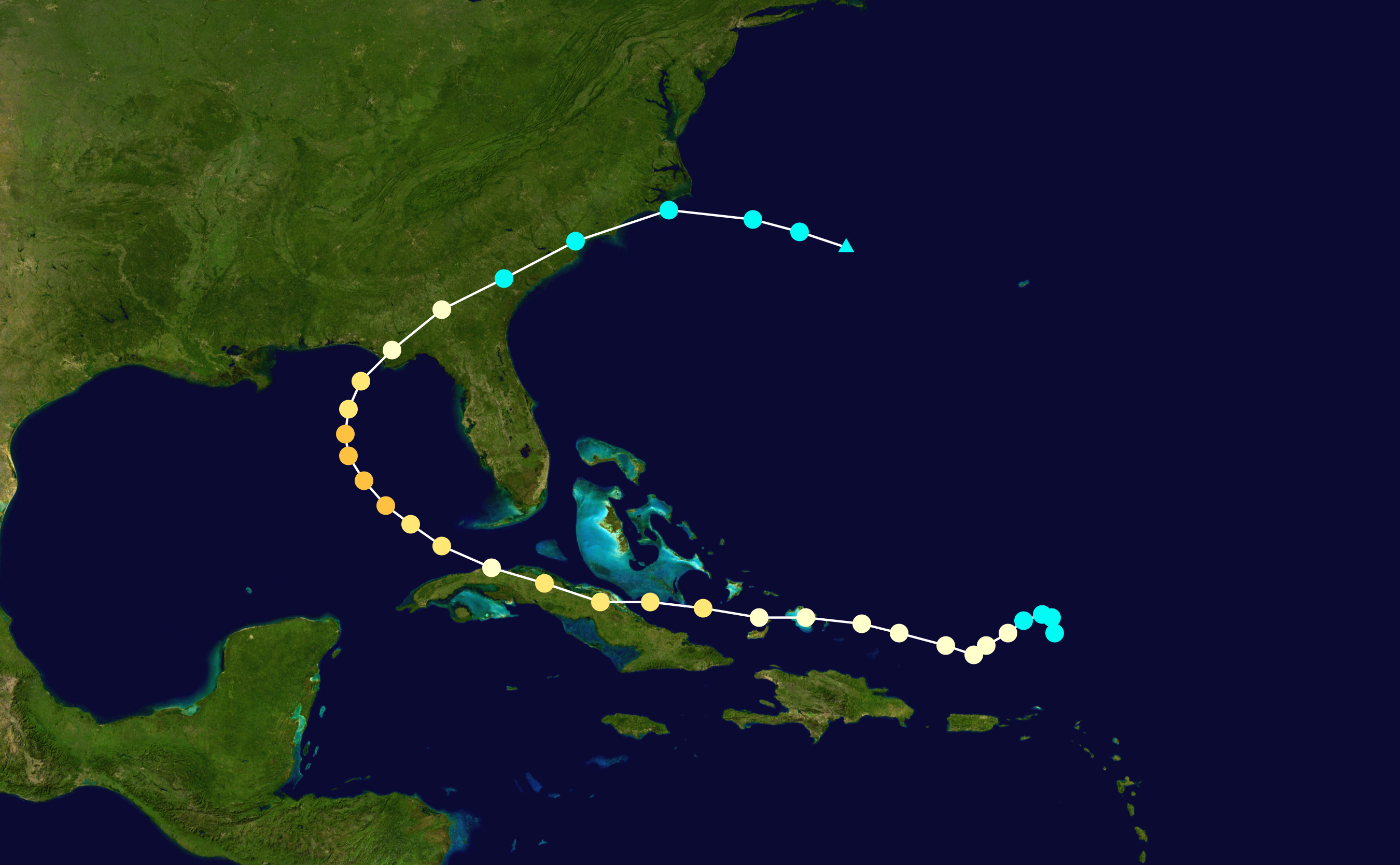
ATL: IKE Discussion

Moderator: S2k Moderators

Message
Author
User avatar
TreasureIslandFLGal
S2K Supporter
S2K Supporter
Posts: 1581
Age: 57
Joined: Sun Aug 15, 2004 6:16 pm
Location: Clearwater, Florida ~3 miles from the coast now. We finally moved safely off the barrier island!

Re: ATL IKE: Category 2 - Discussion

#3341 Postby TreasureIslandFLGal » Sat Sep 06, 2008 12:06 pm

cape_escape wrote:
Sanibel wrote:Normally a deeper curve into Cuba would suggest a sharper hook to follow. But not this year with Gus's NW-WNW track. But this could all be meaningless if the pattern has changed since.

GFS latching onto recurve that GFDL could already be ahead of it on.


I know the set-up is completely different, however I can't help but too remember Charleys right hook after Cuba....Not to mention all the talk about Donna over the past few days. I'm staying on my toes just in case!


you and me both! its no biggie when we start in the middle of the cone, cause we know it will shift later. but when it shifts, and then starts trending back...that is when it is time to worry more.

ideally, the pendulum effect will play out...first to one side, then to the other, then less to the other, then less to the other, until a middle path is finalized. If that is the case, I think the FL/AL line would be the landfall.

BUT I think, like others have said, that being September, it seems likely that a trough or front will either redirect a gulf storm, or else cause a weakness to develop between the ridges that pulls it more northward.

Slow movement in the gulf, aka the GFS, just doesn't ever bode well, and normally means the storm will be shunted NE. And teh GFDL is looking uglier for my area too. I don't like, no I don't. Let's hope the more western thinking pans out afterall.
0 likes   

tolakram
Admin
Admin
Posts: 20020
Age: 62
Joined: Sun Aug 27, 2006 8:23 pm
Location: Florence, KY (name is Mark)

Re: ATL IKE: Category 2 - Discussion

#3342 Postby tolakram » Sat Sep 06, 2008 12:07 pm

Image
0 likes   

Frank2
Category 5
Category 5
Posts: 4061
Joined: Mon Jul 25, 2005 12:47 pm

#3343 Postby Frank2 » Sat Sep 06, 2008 12:08 pm

No, Andrew's track was completely different - had Ike continued due west it would be similar, but, even then it would be different...
0 likes   

User avatar
El Nino
Category 1
Category 1
Posts: 454
Age: 47
Joined: Sun Oct 16, 2005 3:18 pm
Location: Lima - Miraflores (Peru)
Contact:

Re: ATL IKE: Category 2 - Discussion

#3344 Postby El Nino » Sat Sep 06, 2008 12:10 pm

I don't understand how the NHC can projet a 25kts weakening over Cuba if Ike will stay more than one day over the island. I think, it will be downgraded to a TS.
0 likes   

User avatar
cycloneye
Admin
Admin
Posts: 145886
Age: 69
Joined: Thu Oct 10, 2002 10:54 am
Location: San Juan, Puerto Rico

Re: ATL IKE: Recon Discussion

#3345 Postby cycloneye » Sat Sep 06, 2008 12:12 pm

Peak flight level wind before the next pass was at=From 125° at 106 knots
(From the SE at ~ 121.9 mph)
0 likes   

jlauderdal
S2K Supporter
S2K Supporter
Posts: 7188
Joined: Wed May 19, 2004 5:46 am
Location: NE Fort Lauderdale
Contact:

Re: Re:

#3346 Postby jlauderdal » Sat Sep 06, 2008 12:13 pm

Sabanic wrote:
jlauderdal wrote:
dhweather wrote:I'd just ask everyone to ignore the media, unless they are specifically citing the NHC - we've heard "Andrew's path", "Florida panhandle" and so on.

When "judgement day" comes, the only ones held responsible is the NHC.


channel 10 miami is the only media i would pay attention too and only because max mayfield works there, the other stations were horrible with fay

i could easily start my own thread with all the untrue information distributed by local media, its rather pathetic


And we have DBW here in Mobile. As good as it gets.


yep, what is he saying
0 likes   

Brent
S2K Supporter
S2K Supporter
Posts: 38106
Age: 37
Joined: Sun May 16, 2004 10:30 pm
Location: Tulsa Oklahoma
Contact:

Re: ATL IKE: Category 2 - Discussion

#3347 Postby Brent » Sat Sep 06, 2008 12:13 pm

El Nino wrote:I don't understand how the NHC can projet a 25kts weakening over Cuba if Ike will stay more than one day over the island. I think, it will be downgraded to a TS.


It's a compromise. If the storm goes even a little north of their track it would be over a lot less land and would therefore not weaken much. They are covering in case that happens, but yes if it does spend more than a day over Cuba it would weaken a lot more.
0 likes   

StormWarning1
Category 1
Category 1
Posts: 254
Joined: Sun Jul 10, 2005 9:29 pm
Location: Nashville TN

Re: ATL IKE: Category 2 - Discussion

#3348 Postby StormWarning1 » Sat Sep 06, 2008 12:14 pm

El Nino wrote:I don't understand how the NHC can projet a 25kts weakening over Cuba if Ike will stay more than one day over the island. I think, it will be downgraded to a TS.

It is a blend of the possibility it will stay over Cuba a long time or move off Cuba quickly.
They said a lot more weakening if it stays over a long time.
0 likes   

User avatar
deltadog03
Professional-Met
Professional-Met
Posts: 3580
Joined: Tue Jul 05, 2005 6:16 pm
Location: Macon, GA

#3349 Postby deltadog03 » Sat Sep 06, 2008 12:15 pm

Looks like IKE is starting to strengthen a bit....
0 likes   

User avatar
Windy
S2K Supporter
S2K Supporter
Posts: 1628
Joined: Mon Sep 13, 2004 10:13 pm

Re: ATL IKE: Category 2 - Discussion

#3350 Postby Windy » Sat Sep 06, 2008 12:15 pm

El Nino wrote:I don't understand how the NHC can projet a 25kts weakening over Cuba if Ike will stay more than one day over the island. I think, it will be downgraded to a TS.


They don't know how long it will spend over Cuba. They're being statistical about it; drop it by 25 kts and then the forecast won't be off much either way.
0 likes   

User avatar
El Nino
Category 1
Category 1
Posts: 454
Age: 47
Joined: Sun Oct 16, 2005 3:18 pm
Location: Lima - Miraflores (Peru)
Contact:

Re: ATL IKE: Category 2 - Discussion

#3351 Postby El Nino » Sat Sep 06, 2008 12:16 pm

Ok, thank you. Does anybody can tell how are the conditions in the GOM for re-intensification. Will it be like Gustav or like Charley/Katrina ?
0 likes   

User avatar
TreasureIslandFLGal
S2K Supporter
S2K Supporter
Posts: 1581
Age: 57
Joined: Sun Aug 15, 2004 6:16 pm
Location: Clearwater, Florida ~3 miles from the coast now. We finally moved safely off the barrier island!

Re: ATL IKE: Category 2 - Discussion

#3352 Postby TreasureIslandFLGal » Sat Sep 06, 2008 12:16 pm

I hope Ike does stay strong...and here's why:

IF Ike take a considerable hit, it will unravel itself a bit. When that happens, storms end up growing in area a whole lot, and their wind field increases overall, even if the wind speeds weaken (i.e. Gustav) But in this case, the storm will go back into the gulf, over the loop current, and definitely have a good change at strengthening again, especially if it stalls per the GFS. That would result in not only a very strong storm, but a much larger storm in area than we are seeing now. It will still end up a very powerful storm no matter where it hits though.

So which woul dyou rather see? a storm that stays compact, avoids land, and stays the same size...hitting as a major? -- or a storm that is 3 times the size as it is now...that still hits as a major??
Last edited by TreasureIslandFLGal on Sat Sep 06, 2008 12:17 pm, edited 1 time in total.
0 likes   

User avatar
KWT
Category 5
Category 5
Posts: 31415
Joined: Tue Aug 17, 2004 11:02 am
Location: UK!!!

#3353 Postby KWT » Sat Sep 06, 2008 12:17 pm

As others have said just a blend, if it were to take NHC track would probably be weaker.

Also it does seem to be slowing down just a little though it looks as if the eye is elongating W-E which maybe why it looks like its slowed a good deal I'm not sure.
0 likes   

User avatar
El Nino
Category 1
Category 1
Posts: 454
Age: 47
Joined: Sun Oct 16, 2005 3:18 pm
Location: Lima - Miraflores (Peru)
Contact:

Re: ATL IKE: Recon Discussion

#3354 Postby El Nino » Sat Sep 06, 2008 12:18 pm

Now, what's the official pressure ? 954 or 958 ?
0 likes   

User avatar
KWT
Category 5
Category 5
Posts: 31415
Joined: Tue Aug 17, 2004 11:02 am
Location: UK!!!

Re: ATL IKE: Category 2 - Discussion

#3355 Postby KWT » Sat Sep 06, 2008 12:19 pm

El Nino wrote:Ok, thank you. Does anybody can tell how are the conditions in the GOM for re-intensification. Will it be like Gustav or like Charley/Katrina ?


NHC expecting conditions to be rather condusive so I'm guessing that there won't be the shear that was in the gulf with Gustav and therefore Ike will likely strengthen.
0 likes   

User avatar
LowndesCoFire
Tropical Storm
Tropical Storm
Posts: 137
Age: 43
Joined: Tue Aug 19, 2008 5:03 pm
Location: Valdosta, GA

#3356 Postby LowndesCoFire » Sat Sep 06, 2008 12:19 pm

Image

Does anyone think that a track such as this is shaping up in the future? (Kate 1985)
0 likes   

sprink52
Tropical Storm
Tropical Storm
Posts: 212
Joined: Wed Aug 11, 2004 1:25 pm
Location: Royal Palm Beach, Fl

Re: ATL IKE: Category 2 - Discussion

#3357 Postby sprink52 » Sat Sep 06, 2008 12:20 pm

This is Google Earth's image of Ike and the NHC Track...sort of kool.

Image
0 likes   

User avatar
KWT
Category 5
Category 5
Posts: 31415
Joined: Tue Aug 17, 2004 11:02 am
Location: UK!!!

#3358 Postby KWT » Sat Sep 06, 2008 12:20 pm

LowndesCoFire, too early to say but the GFS is suggesting something rather close that, maybe hitting Cuba a touch further east however I reckonand spending a good bit more time overland therefore as a result.
0 likes   

Frank2
Category 5
Category 5
Posts: 4061
Joined: Mon Jul 25, 2005 12:47 pm

#3359 Postby Frank2 » Sat Sep 06, 2008 12:22 pm

Per Hurakan's post, no, it's still on the same heading mentioned in the TCD...

I agree about Max Mayfield - he's been very good to listen to about Gustav and Ike, though I worry that, unlike when he was at the NHC, he might feel some pressure from the Producer to "hype" things up a bit - I hope that isn't the case...

The other channels have ranged from "all right" to totally wrong, but, at times they've all given bits of good information...

Still, I agree that between listening to only Max Mayfield, Steve Lyons and the NHC forecasters is the best bet, since the OCM's always do go for the hard sell, and, that includes the hype...

I had to laugh yesterday when one of the OCM's (Jim Cantore or Mike Siedel) were on the beach in the Carolinas "wearin' the blue thing" (as Bill Cosby once referred to it), complete with rain-gear TWC hat, but, in the background, kids could be seen playing in the sand in shorts and t-shirts...

The media - you have to love 'em (or leave 'em)...

LOL
Last edited by Frank2 on Sat Sep 06, 2008 12:26 pm, edited 1 time in total.
0 likes   

User avatar
Sabanic
Category 2
Category 2
Posts: 683
Age: 65
Joined: Wed Aug 01, 2007 7:01 am
Location: Mobile, AL
Contact:

Re: Re:

#3360 Postby Sabanic » Sat Sep 06, 2008 12:25 pm

jlauderdal wrote:And we have DBW here in Mobile. As good as it gets.


yep, what is he saying[/quote]

jl not much we do not already know, but he did say it was a little too early to know excactly where Ike would go, but he hinted at landfall possibly being somewhere from SE/LA to the Big Bend.
0 likes   


Return to “2008”

Who is online

Users browsing this forum: No registered users and 6 guests