ATL: IKE Discussion
Moderator: S2k Moderators


Re: Re:
Stormcenter wrote:Texashawk wrote:The 11 AM NHC forecast track would be the doomsday storm for Galveston.
The NHC keeps Ike at 100 knots before landfall so that is a positive.

100 knts....piece o cake....lol
Time to think about making some initial preparations. If the forecast is similar tommorow morn, SE Texas will be nuts.
0 likes
-
HouTXmetro

- Category 5

- Posts: 3949
- Joined: Sun Jun 13, 2004 6:00 pm
- Location: District of Columbia, USA


Re: Re:
Stormcenter wrote:Texashawk wrote:The 11 AM NHC forecast track would be the doomsday storm for Galveston.
The NHC keeps Ike at 100 knots before landfall so that is a positive.
Unless western Cuba kills Ike like it did Gustav, which I don't think will happen, Ike will spend the better part of four days in the gulf with alot better conditions for strengthening than Gustav ever had.
100 kts seems really conservative...
Last edited by baitism on Mon Sep 08, 2008 10:08 am, edited 1 time in total.
0 likes
-
pablolopez26
- Tropical Storm

- Posts: 137
- Joined: Wed Aug 27, 2008 5:10 pm
Re:
KatDaddy wrote: We may not be as lucky this time around. Definitley a flash back to Rita.
I hope you are wrong and this thing hits somewhere else. Can you imagine Houston with no power for even 1 week? Not a pretty picture.
0 likes

Re: ATL IKE: Category 2 - Discussion
11:00am position - still moving wes & now moving into the Caribbean Sea.

Last edited by TampaFl on Mon Sep 08, 2008 10:30 am, edited 2 times in total.
0 likes
-
Stormcenter
- S2K Supporter

- Posts: 6687
- Joined: Wed Sep 03, 2003 11:27 am
- Location: Houston, TX
Re:
HouTXmetro wrote:Guys, why are we arguing over semantics? A formidable Hurricane will be in the Gulf in a couple of days. Jeez, that's the bottom line!
I agree.
0 likes
-
ConvergenceZone
.gif)
- Category 5
- Posts: 5241
- Joined: Fri Jul 29, 2005 1:40 am
- Location: Northern California
Re: Re:
Stormcenter wrote:Texashawk wrote:The 11 AM NHC forecast track would be the doomsday storm for Galveston.
The NHC keeps Ike at 100 knots before landfall so that is a positive.
they will raise the winds if this doesn't weaken as much as forecast, and remember the error in winds is huge...I think it will be a high cat 3 or 4 in that hot gulf low shear environment.
0 likes
Re: ATL IKE: Category 2 - Discussion
You Gulf coasters didn't want Ike to re-emerge straight out into the Caribbean as it has.
0 likes


Re: Re:
ConvergenceZone wrote:Stormcenter wrote:Texashawk wrote:The 11 AM NHC forecast track would be the doomsday storm for Galveston.
The NHC keeps Ike at 100 knots before landfall so that is a positive.
they will raise the winds if this doesn't weaken as much as forecast, and remember the error in winds is huge...I think it will be a high cat 3 or 4 in that hot gulf low shear environment.
Remember too that the water south of Cuba is the warmest in the entire Atlantic basin. The difference in strength between it going over that water and over Cuba itself is night and day.
0 likes
-
PTrackerLA

- Category 5
- Posts: 5281
- Age: 42
- Joined: Thu Oct 10, 2002 8:40 pm
- Location: Lafayette, LA
Re: ATL IKE: Category 2 - Discussion
I sure hope they can pick up everyone's storm debris before around here before Ike makes landfall. A SE TX hit as a large hurricane would certainly place my area in TS conditions and make quite the mess once again. Winds would be strongest from the opposite direction (south) as they were with Gus so weakened trees could fall leading to more problems. Basically exactly what we DON'T need less than 2 weeks after Gustav. Surge would also be a major issue ala Rita. Terrible scenario for our state.
0 likes
-
Air Force Met
- Military Met

- Posts: 4372
- Age: 56
- Joined: Tue Jul 08, 2003 9:30 am
- Location: Roan Mountain, TN
Re: Re:
Derek Ortt wrote:Stormcenter wrote:gboudx wrote:To those doubting jeff on the windfield expansion, he said on a recent conference call he sees a Katrina/Carla sized storm. But not as big as Gilbert. I didn't realize we had so many experts on this board. We are so blessed.
The NHC makes no mention of it (they normally would) their 11:00am discussion so I'll
leave it at that.
I think you're in denial this time
Mee too. Get over what or what not the NHC mentions. Intensity or size. Trust me.
0 likes


-
vbhoutex

- Storm2k Executive

- Posts: 29139
- Age: 74
- Joined: Wed Oct 09, 2002 11:31 pm
- Location: Cypress, TX
- Contact:
Re: Re:
pablolopez26 wrote:KatDaddy wrote: We may not be as lucky this time around. Definitley a flash back to Rita.
I hope you are wrong and this thing hits somewhere else. Can you imagine Houston with no power for even 1 week? Not a pretty picture.
Been there done that and don't ever want to do it again. 1983-Alicia
0 likes
Re: ATL IKE: Category 2 - Discussion
NHC Forecast trend of cumulative probability of the locations below experiencing 34kt, 50kt, 64kt in the forecast period (120 hours). The first % is what was forecast with 5am Monday advisory, the second % (in bold) is the current monday 11 am forecast probability.
Keep an eye on these with each new forecast advisory...it helps to see trends and assess risk.
Key West
34kt 55%-51%
50kt 18%-17%
64kt 6%-5%
Tampa
34kt 24%-22%
50kt 6%-4%
64kt 2%-2%
Pensacola
34kt 28%-27%
50kt 11%-9%
64kt 5%-4%
Gulfport
34kt 32%-33%
50kt 13%-12%
64kt 5%-5%
New Orleans
34kt 36%-37%
50kt 14%-14%
64kt 5%-5%
Galveston
34kt 22%-24%
50kt 9%-10%
64kt 5%-6%
0 likes

-
weatherbud

- Tropical Low

- Posts: 29
- Joined: Tue Apr 08, 2008 7:03 am
- Location: CA
- Contact:
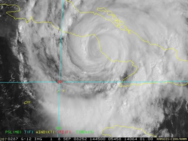
Hurricane Ike is now a Category 2, moves through Cuba. Texas is next?
Hurricane IKE has been downgraded to a Category 2 hurricane at this hour. IKE is rolling through Northern Cuba with winds of 100mph. I do expect it to get weaker as it stays over land the next 24-48 hours. Cuba is a long but NARROW country so IKE should be able to recover once it moves away from Cuba on Wednesday sometime. After that it heads into the open Gulf of Mexico.


Hurricane IKE has been downgraded to a Category 2 hurricane at this hour. IKE is rolling through Northern Cuba with winds of 100mph. I do expect it to get weaker as it stays over land the next 24-48 hours. Cuba is a long but NARROW country so IKE should be able to recover once it moves away from Cuba on Wednesday sometime. After that it heads into the open Gulf of Mexico.
0 likes


Who is online
Users browsing this forum: No registered users and 34 guests