
I was reading in the Ike Model page that Ikes track will take it into Matagorda Bay. Is this true?
I guess he was basing his info on a model run that is not out yet?? Thanks all!
ATL: IKE Discussion
Moderator: S2k Moderators


Re:
pablolopez26 wrote:I was reading in the Ike Model page that Ikes track will take it into Matagorda Bay. Is this true?
I guess he was basing his info on a model run that is not out yet?? Thanks all!
GFDL did shift north in the latest run but this is ONE model and its still several days away.....stay tuned
0 likes


pablolopez26, models are shifting about however some are showing a landfall in that area and now even further north again.
jinftl, yeah the gradient is really heping the winds, though I suppose the squalls are quite strong as well in thier own right.
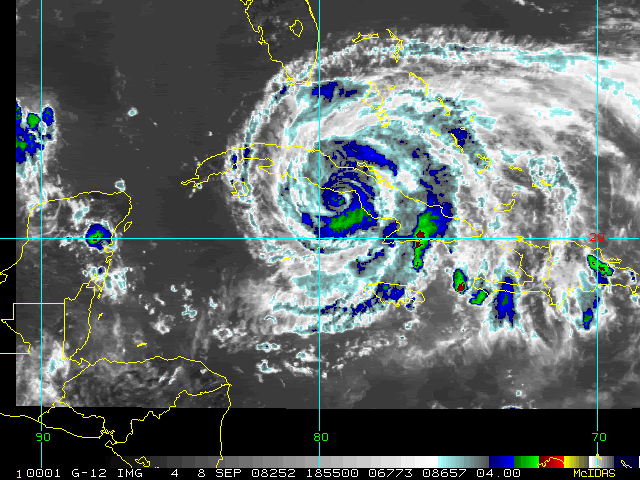
Ike still looks nice and tight in terms of the central core of convection, northern part emerging slowly but surely.
jinftl, yeah the gradient is really heping the winds, though I suppose the squalls are quite strong as well in thier own right.
Ike still looks nice and tight in terms of the central core of convection, northern part emerging slowly but surely.
0 likes

Hurakan, very impressive, the eye is closing up a little but otherwise the presentation is every bit as good as it was whilst it was over the Caribbean, doesn't seem to have weakened much at all, I do wonder what recon will show in that northern quadrant as it emerges from Cuba in the next hour and just what sort of pressure we will have.
0 likes
Re: ATL IKE: Category 1 - Discussion
HURRICANE IKE LOCAL STATEMENT
NATIONAL WEATHER SERVICE MIAMI FL
1214 PM EDT TUE SEP 9 2008
...TROPICAL STORM WARNING NOW IN EFFECT FOR THE GULF WATERS...
...OUTER BANDS OF IKE AFFECTING MAINLAND SOUTH FLORIDA...
THE STRONGEST WINDS ACROSS MAINLAND SOUTH FLORIDA HAVE BEEN
OBSERVED ACROSS MIAMI-DADE AND MAINLAND MONROE COUNTIES DURING
THIS MORNING AND EARLY AFTERNOON, THE CLOSEST COUNTIES TO THE
CENTER OF IKE. AT FLAMINGO SUSTAINED WINDS OF 52 MPH GUSTING TO 63 MPH
WERE RECORDED AT 846 AM EDT AS A RAIN BAND MOVED OVER THE AREA. SUSTAINED
WINDS WERE 30 TO 35 MPH WITH GUSTS TO 44 MPH AT SEVERAL INLAND
LOCATIONS. WINDS ALONG THE METRO ATLANTIC COAST BEACHES WILL BE
EASTERLY AT 25 TO 35 MPH GUSTING AS HIGH AS 55 MPH ESPECIALLY IN
SQUALLS ASSOCIATED WITH THE SPIRAL BANDS AS THEY MOVE RAPIDLY
ONSHORE TODAY.
0 likes
-
cape_escape

- Category 2

- Posts: 745
- Age: 57
- Joined: Fri Aug 13, 2004 2:39 am
- Location: Cape Coral Florida
- Contact:
Re: Re:
jinftl wrote:It is consistently windier today in my opinion than it was with fay..and she was so much closer. But if the gradient is partly the culpit, than that explains why it is so windy 300+ miles from center.
Pretty nasty band moving through Miami...if we are seeing sustained winds of 20-30...that band could have some brief gusts well over 40 mph.KWT wrote:Yeah the wind in Florida is being enhanced by the gradient between the high and Ike, still pretty impressive though.
Also the GFDL has really shifted north...in a big way
Lake Wind Advisory - Lee (Florida)
Updated: Tue, 09 Sep 2008 12:55:18
LAKE WIND ADVISORY IN EFFECT UNTIL 7 PM EDT THIS EVENING...
FLZ055>057-060>062-065-092300-
/O.NEW.KTBW.LW.Y.0007.080909T1500Z-080909T2300Z/
MANATEE-HARDEE-HIGHLANDS-SARASOTA-DE SOTO-CHARLOTTE-LEE-
INCLUDING THE CITIES OF...BRADENTON...WAUCHULA...SEBRING...
AVON PARK...SARASOTA...VENICE...ARCADIA...PORT CHARLOTTE...
PUNTA GORDA...CAPE CORAL...FORT MYERS
905 AM EDT TUE SEP 9 2008
...LAKE WIND ADVISORY IN EFFECT UNTIL 7 PM EDT THIS EVENING...
THE NATIONAL WEATHER SERVICE IN TAMPA BAY AREA - RUSKIN FL HAS
ISSUED A LAKE WIND ADVISORY...WHICH IS IN EFFECT UNTIL 7 PM EDT
THIS EVENING.
WINDS WILL INCREASE TODAY AS HURRICANE IKE PASSES BY DIRECTLY TO
OUR SOUTH. SUSTAINED WINDS OVER 20 MPH ARE LIKELY OVER AREA LAKES
WITH GUSTS TO 30 MPH.
A LAKE WIND ADVISORY IS ISSUED WHEN SUSTAINED WINDS ARE FORECAST
TO BE 20 TO 29 MPH WITH FREQUENT GUSTS TO NEAR OR ABOVE GALE FORCE
FOR AT LEAST 3 HOURS. WINDS OF THESE MAGNITUDES WILL CREATE ROUGH
CONDITIONS ON LARGER AREA LAKES WHICH COULD PRODUCE DAMAGE TO...OR
FLIP...SMALL PLEASURE CRAFT.
OUTDOOR ENTHUSIASTS MAY WISH TO POSTPONE LAKE RELATED ACTIVITIES
UNTIL CONDITIONS IMPROVE.
$$
Issuing Weather Forecast Office Homepage
0 likes
-
Brent
- S2K Supporter

- Posts: 38730
- Age: 37
- Joined: Sun May 16, 2004 10:30 pm
- Location: Tulsa Oklahoma
- Contact:
Re: ATL IKE: Category 1 - Discussion
From the 2pm advisory:
A GUST TO 118 MPH WAS RECENTLY REPORTED AT PASO REAL IN
PINAR DEL RIO.
A GUST TO 118 MPH WAS RECENTLY REPORTED AT PASO REAL IN
PINAR DEL RIO.
0 likes
-
tolakram
- Admin

- Posts: 20179
- Age: 62
- Joined: Sun Aug 27, 2006 8:23 pm
- Location: Florence, KY (name is Mark)
Re:
KWT wrote:Hurakan, very impressive, the eye is closing up a little but otherwise the presentation is every bit as good as it was whilst it was over the Caribbean, doesn't seem to have weakened much at all, I do wonder what recon will show in that northern quadrant as it emerges from Cuba in the next hour and just what sort of pressure we will have.
Please note that my observations of those mountains in Cuba do not mean Ike won't strengthen again. Honestly I'm not even concerned about that, I'm just testing my theory that that small clump of rather steep hills can really disrupt the core.
With that out of the way, I think you can see on the visible when Ike hits that area.
http://hadar.cira.colostate.edu/ramsdis ... ive_0.html
The AVN loop shows this a bit better:
http://www.ssd.noaa.gov/goes/flt/t4/loop-avn.html
It will be interesting to see what happens when it gets back over water.
2PM update

Last edited by tolakram on Tue Sep 09, 2008 1:04 pm, edited 1 time in total.
0 likes

-
CrazyC83
- Professional-Met

- Posts: 34315
- Joined: Tue Mar 07, 2006 11:57 pm
- Location: Deep South, for the first time!
Re: ATL IKE: Category 1 - Discussion
Brent wrote:From the 2pm advisory:
A GUST TO 118 MPH WAS RECENTLY REPORTED AT PASO REAL IN
PINAR DEL RIO.
From what I can figure out based on Google Earth and coordinates, that is less than 100 feet above sea level so it would be very much representative of the storm's intensity. A gust of 102 kt would normally support an intensity around 80 kt.
0 likes
Totally agree Nexus the structure clearly looks better upon exit into the gulf of Mexico then the first time round when it was having a hard time with the outer eyewall still.
It seems to me its got the shape to really strengthen once its decent away from Cuba in quite a big way, given how tight the inner core is I really wouldn't be all that shocked to see this undergo RI about 12-24hrs time.
It seems to me its got the shape to really strengthen once its decent away from Cuba in quite a big way, given how tight the inner core is I really wouldn't be all that shocked to see this undergo RI about 12-24hrs time.
0 likes
-
southerngale

- Retired Staff

- Posts: 27418
- Joined: Thu Oct 10, 2002 1:27 am
- Location: Southeast Texas (Beaumont area)
Re: ATL IKE: Category 1 - Discussion
Sabanic wrote:Looks like 2PM has shifted southward again?
They don't adjust the track at intermediate advisories.
0 likes
-
Stormcenter
- S2K Supporter
- Posts: 6689
- Joined: Wed Sep 03, 2003 11:27 am
- Location: Houston, TX
Re: ATL IKE: Category 1 - Discussion
Sabanic wrote:Looks like 2PM has shifted southward again?
What shifted southward at 2pm?
0 likes
Who is online
Users browsing this forum: No registered users and 47 guests