ATL: IKE Discussion
Moderator: S2k Moderators
-
Stratusxpeye

- Category 2

- Posts: 686
- Joined: Tue Jun 07, 2005 10:40 am
- Location: Tampa, Florida
- Contact:
Re: ATL IKE: Category 1 - Discussion
IKE Has something to offer a little later in the week. The north trend should continue and the 5PM NHC track should come north a little bit more. We'll have to see what IKE does over the gulf. NHC is downplaying the intensity of IKE due to the huge error in intensity for Gustav. No saying this will be a CAT5 or anything but it'll be interesting to watch.
0 likes
-
pablolopez26
- Tropical Storm

- Posts: 137
- Joined: Wed Aug 27, 2008 5:10 pm
Re: ATL IKE: Category 1 - Discussion
Look at the models for Ike since inception coming off of Africa. Crazy!!!
http://flhurricane.com/sbanimator.php?year=2008&storm=09
http://flhurricane.com/sbanimator.php?year=2008&storm=09
0 likes
Re: ATL IKE: Category 1 - Discussion
Sorry guys....It appears after I checked in for my flight to Florida tomorrow the models started trending up the Texas coast. Somehow I knew that would happen. 

Shannon
Shannon
0 likes
-
mattpetre
- Category 2
- Posts: 510
- Age: 54
- Joined: Mon Sep 19, 2005 3:20 pm
- Location: Missouri City,TX & Galleria
- Contact:
Re: ATL IKE: Category 1 - Discussion
That historical model animation just shows how the 3 day is decent and the 5 day can be way off... We are almost to the point of getting a decent prediction for IKE but not quite yet.
0 likes
-
pablolopez26
- Tropical Storm
- Posts: 137
- Joined: Wed Aug 27, 2008 5:10 pm
Re: ATL IKE: Category 1 - Discussion
mattpetre wrote:That historical model animation just shows how the 3 day is decent and the 5 day can be way off... We are almost to the point of getting a decent prediction for IKE but not quite yet.
I think the key here is waiting until the models come to some sort of an agreement. Right now, their all over the place.
My best guesstimate, and this is not official or anything, is that IKE will come ashore between CC and Port Arthur Texas.
And i hate to put it this way because any hit is a bad hit, but i for one hope it hits north of Houston so we dont get the dirty side. I dont think Houston can handle it.
0 likes
-
tolakram
- Admin

- Posts: 20179
- Age: 62
- Joined: Sun Aug 27, 2006 8:23 pm
- Location: Florence, KY (name is Mark)
Re: ATL IKE: Category 1 - Discussion

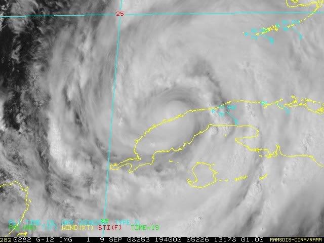
Loop:
http://hadar.cira.colostate.edu/ramsdis ... at2_0.html
I think my mountain theory has some validity. Look how it strips Ike of convection as he hits the midway point, about where the mountains start. I do not think this will impede Ike's reorganization, I'm just observing how this small clump of hills can really disrupt these storms.
0 likes


-
HouTXmetro

- Category 5

- Posts: 3949
- Joined: Sun Jun 13, 2004 6:00 pm
- Location: District of Columbia, USA

Re: ATL IKE: Category 1 - Discussion
tolakram wrote:
Loop:
http://hadar.cira.colostate.edu/ramsdis ... at2_0.html
I think my mountain theory has some validity. Look how it strips Ike of convection as he hits the midway point, about where the mountains start. I do not think this will impede Ike's reorganization, I'm just observing how this small clump of hills can really disrupt these storms.
Its interesting...BUT Ike did the exact same thing going over low land very early yesterday as well, held convection well till it reached the coast then died off...the reason I think is because the outer bands reach the sea sooner and therefore take energy away from the core, so the convection there weakens until the core can get into the water as well. No doubt though the mountions obviously do have a role, possibly a fairly big one.
Last edited by KWT on Tue Sep 09, 2008 2:53 pm, edited 1 time in total.
0 likes

Re: ATL IKE: Category 1 - Discussion
jinftl wrote:Latest obsv from Key West (2pm)
KEY WEST INTL LGT RAIN 82 73 74 SE40G60
I am curious if water is getting push onshore, esp. in places like S. Roosevelt Blvd in Key West.

Debris partially blocks South Roosevelt Boulevard Tuesday morning.
Photo by Rob O'Neal
http://images.keysnews.com/galleries/ne ... /index.htm
Last edited by artist on Tue Sep 09, 2008 2:55 pm, edited 1 time in total.
0 likes
-
Canelaw99

- S2K Supporter

- Posts: 2128
- Age: 49
- Joined: Tue Aug 31, 2004 8:27 am
- Location: Homestead, FL
Re: ATL IKE: Category 1 - Discussion
Definitely a nasty band in this area. The tornado warning was cancelled, but I just heard thunder. First thunder I've heard out of any of these bands today...
0 likes
HouTXmetro, I've got a sneaky feeling it may well do so, next shear maps should be updated soon, will be interesting to see if shear is decreasing or increasing.
The other thing to note is systems that come off land typically take 6-12hrs to really ramp up even if the structure is strong, I've no doubt this could be getting close major status in 24hrs time, but I want to see the shear tendency before making that sort of call!
The other thing to note is systems that come off land typically take 6-12hrs to really ramp up even if the structure is strong, I've no doubt this could be getting close major status in 24hrs time, but I want to see the shear tendency before making that sort of call!
0 likes
-
AdvAutoBob

- S2K Supporter
- Posts: 85
- Joined: Mon Aug 30, 2004 5:03 pm
- Location: North Ft Myers, FL
- Contact:
Re: ATL IKE: Category 1 - Discussion
Currently getting some squally rains and wind from one of Ike's outer bands here in Cape Coral...
Glad I didn't ride my motorcycle in today
Glad I didn't ride my motorcycle in today
0 likes

Re: ATL IKE: Category 1 - Discussion
Page 175-Ike Models Discussion-HUGE REAL ESTATE SALE GOING ON NOW-DON'T MISS OUT! 
0 likes
-
Cape Verde

- Category 2
- Posts: 564
- Age: 70
- Joined: Tue Aug 31, 2004 5:53 pm
- Location: Houston area
Re: ATL IKE: Category 1 - Discussion
Well, we in Houston did at least enjoy the morning. When we woke up to go to work, Ike was headed for No Man's Land of the King Ranch in south Texas.
Now, it appears that brief period of relief has been replaced with anxiety. Any landfall from Matagorda Bay to Galveston would be absolutely horrible.
Now, it appears that brief period of relief has been replaced with anxiety. Any landfall from Matagorda Bay to Galveston would be absolutely horrible.
0 likes
Re: ATL IKE: Category 1 - Discussion
Canelaw99 wrote:Definitely a nasty band in this area. The tornado warning was cancelled, but I just heard thunder. First thunder I've heard out of any of these bands today...
Yeah radar returns have shown that the bands that have gone through the Keys and also south Florida are pretty impressive I have to admit!
Center now over the water, now we can see what happens with 3 days over the gulf, plenty of time for this system to strengthen.
0 likes
-
Stormcenter
- S2K Supporter
- Posts: 6689
- Joined: Wed Sep 03, 2003 11:27 am
- Location: Houston, TX
A Pretty good afternoon discussion from the NWS out of Miami, Fl.
Synopsis...all eyes remain on Hurricane Ike as the rest of the
tropical Atlantic is mercifully quiet for the time being. Ike made
another landfall in Cuba and will finally emerge into the southeast Gulf of Mexico this afternoon. A deep layer ridge exists north of the system from the western North Atlantic across the Gulf states and into the northwestern
Gomex. This ridge will keep Ike well away from the forecast area. The official track forecast for Ike has moved decidedly to the left (or w) over the last 24 hours although a slight adjustment to the right was made with the last advisory once the system approaches Texas. The latest landfall estimate brings Ike ashore near Corpus Christi Texas on the morning of Friday the 13th. The official track splits the difference between the GFS and Euro tracks through about 48 hours and then more closely follows the GFS thereafter.
0 likes
-
Sabanic

- Category 2
- Posts: 683
- Age: 66
- Joined: Wed Aug 01, 2007 7:01 am
- Location: Mobile, AL
- Contact:
Re:
Stormcenter wrote:A Pretty good afternoon discussion from the NWS out of Miami, Fl.
Synopsis...all eyes remain on Hurricane Ike as the rest of the
tropical Atlantic is mercifully quiet for the time being. Ike made
another landfall in Cuba and will finally emerge into the southeast Gulf of Mexico this afternoon. A deep layer ridge exists north of the system from the western North Atlantic across the Gulf states and into the northwestern
Gomex. This ridge will keep Ike well away from the forecast area. The official track forecast for Ike has moved decidedly to the left (or w) over the last 24 hours although a slight adjustment to the right was made with the last advisory once the system approaches Texas. The latest landfall estimate brings Ike ashore near Corpus Christi Texas on the morning of Friday the 13th. The official track splits the difference between the GFS and Euro tracks through about 48 hours and then more closely follows the GFS thereafter.
It would be fairly accurate if Friday was the 13th
0 likes

Re:
Stormcenter wrote:A Pretty good afternoon discussion from the NWS out of Miami, Fl.
Synopsis...all eyes remain on Hurricane Ike as the rest of the
tropical Atlantic is mercifully quiet for the time being. Ike made
another landfall in Cuba and will finally emerge into the southeast Gulf of Mexico this afternoon. A deep layer ridge exists north of the system from the western North Atlantic across the Gulf states and into the northwestern
Gomex. This ridge will keep Ike well away from the forecast area. The official track forecast for Ike has moved decidedly to the left (or w) over the last 24 hours although a slight adjustment to the right was made with the last advisory once the system approaches Texas. The latest landfall estimate brings Ike ashore near Corpus Christi Texas on the morning of Friday the 13th. The official track splits the difference between the GFS and Euro tracks through about 48 hours and then more closely follows the GFS thereafter.
They must mean Saturday the 13th.
0 likes
-
gboudx

- S2K Supporter
- Posts: 4090
- Joined: Thu Sep 04, 2003 1:39 pm
- Location: Rockwall, Tx but from Harvey, La
Re: Re:
Sabanic wrote:Stormcenter wrote:A Pretty good afternoon discussion from the NWS out of Miami, Fl.
Synopsis...all eyes remain on Hurricane Ike as the rest of the
tropical Atlantic is mercifully quiet for the time being. Ike made
another landfall in Cuba and will finally emerge into the southeast Gulf of Mexico this afternoon. A deep layer ridge exists north of the system from the western North Atlantic across the Gulf states and into the northwestern
Gomex. This ridge will keep Ike well away from the forecast area. The official track forecast for Ike has moved decidedly to the left (or w) over the last 24 hours although a slight adjustment to the right was made with the last advisory once the system approaches Texas. The latest landfall estimate brings Ike ashore near Corpus Christi Texas on the morning of Friday the 13th. The official track splits the difference between the GFS and Euro tracks through about 48 hours and then more closely follows the GFS thereafter.
It would be fairly accurate if Friday was the 13th
If it was, then someone could photoshop the head of Jason onto Ike. You know, for the cinematic effect.
0 likes
Who is online
Users browsing this forum: No registered users and 16 guests