ATL IKE: Models Discussion
Moderator: S2k Moderators
-
srainhoutx

- S2K Supporter

- Posts: 6919
- Age: 68
- Joined: Sun Jan 14, 2007 11:34 am
- Location: Haywood County, NC
- Contact:
Re: ATL IKE: Models Discussion
jasons wrote:PTrackerLA wrote:That Euro would lead to a nasty surge even in SW LA. Not good news. Most people in LA have already written Ike off but this goes to show we must still watch it. My initial thoughts of Matagorda - Vermilion bay might just pan out. I have a strong feeling we aren't done with these shifts, thoughts anyone else?
Been saying Corpus to Sabine Pass for two full days now. That's my story and I'm stickin' to it.
I also think the models will "simma' down now", now that they are catching the trough and turning Ike northward over Texas (instead of barelling west into Mexico). I also expect a very gradual shift over the next few days to the right. The timing here will be critical and could make a big difference in the end.
Sorry Ed, but it looks like a trip to the beer cooler for you.
WRT to Galveston - as Jeff L. said, they will make the call tomorrow. But with the track likely shifting right now, that would put Galveston in a warning when one is issued. So yes, I do expect tomorrow a mandatory evacuation will be issued for Galveston along with contraflow and the whole nine yards.
Agreed. Long days ahead for TX/SW LA. Models should tighten up tomorrow with all the WFO data as well as NOAA missions scheduled.
0 likes
-
Comanche

- Category 1

- Posts: 381
- Age: 54
- Joined: Wed Jul 06, 2005 9:33 am
- Location: Clear Lake City Texas
Re: ATL IKE: Models Discussion
4/3.5/2 for sale, Clear Lake Texas. Great schools. Seller motivated, needs to close by this Friday!
0 likes

Re: ATL IKE: Models Discussion
Comanche wrote:4/3.5/2 for sale, Clear Lake Texas. Great schools. Seller motivated, needs to close by this Friday!
No need to panic yet, A landfall point is not at possible now.
It all depends on timing, trough, high pressure, erosion of ridge, track, intensity, what Ed wants
0 likes

Re: ATL IKE: Models Discussion
Comanche wrote:4/3.5/2 for sale, Clear Lake Texas. Great schools. Seller motivated, needs to close by this Friday!
or you can move to lovely Dickinson just a few miles south and only 6 miles from wonderful skiing and fishing in Galveston Bay. I'll even throw in a huge discount if you close by Thursday!
No panic, just very tired.

0 likes
-
southerngale

- Retired Staff

- Posts: 27418
- Joined: Thu Oct 10, 2002 1:27 am
- Location: Southeast Texas (Beaumont area)
Re: ATL IKE: Models Discussion
dwg71 wrote:Comanche wrote:4/3.5/2 for sale, Clear Lake Texas. Great schools. Seller motivated, needs to close by this Friday!
No need to panic yet, A landfall point is not at possible now.
It all depends on timing, trough, high pressure, erosion of ridge, track, intensity, what Ed wants, too many factors still out there to panic.
Nobody is panicking. It was a joke, and it was really funny.
I feel better today than I did a few days ago, but not liking today's shift. Hope it's not a trend.
0 likes

Re: ATL IKE: Models Discussion
This is looking eerily similar to Rita in my opinion. It does have more latitude to gain as Rita came from the East between Florida and Cuba. NHC Forecast for Rita was around corpus with the models shifting North each day.
Last edited by rainman on Tue Sep 09, 2008 2:59 pm, edited 1 time in total.
0 likes

Re: ATL IKE: Models Discussion
dwg71 wrote:Comanche wrote:4/3.5/2 for sale, Clear Lake Texas. Great schools. Seller motivated, needs to close by this Friday!
No need to panic yet, A landfall point is not at possible now.
It all depends on timing, trough, high pressure, erosion of ridge, track, intensity, what Ed wants
Yeah but if landfall is still on for Saturday, then mandatory evacuations should be issued tomorrow. It's getting too late to play it by day.
0 likes
Re: ATL IKE: Models Discussion
rainman wrote:This is looking eerily similar to Rita in my opinion. It does have more latitude to gain as Rita came from the East between Florida and Cuba. NHC Forecast for Rita was around corpus with the models shifting North each day.
Ike will be right on her path in about 24 hours, so its possible.
0 likes
-
pablolopez26
- Tropical Storm

- Posts: 137
- Joined: Wed Aug 27, 2008 5:10 pm
looking at water vapor, I have my doubts about the strength of the shortwave, it appears to be moving more west to east than North and South in its movement and the high pressure seems to be "mending" from western gulf to East coast of FL pretty quickly which would move Ike more west.
Time will tell.
Time will tell.
0 likes

Re: ATL IKE: Models Discussion
Comanche wrote:4/3.5/2 for sale, Clear Lake Texas. Great schools. Seller motivated, needs to close by this Friday!
that is soooo funny
I do wish y'all the best .... but I did laugh at that one ...especially being a Realtor.
0 likes
Re: ATL IKE: Models Discussion
Duddy wrote:Yeah but if landfall is still on for Saturday, then mandatory evacuations should be issued tomorrow. It's getting too late to play it by day.
Pretty sure Galveston started evacuations on the Wednesday before Rita - I think it was the medical evacuations.
Last edited by Shoshana on Tue Sep 09, 2008 3:12 pm, edited 1 time in total.
0 likes
-
pablolopez26
- Tropical Storm
- Posts: 137
- Joined: Wed Aug 27, 2008 5:10 pm

-
ELF62

- Tropical Low

- Posts: 12
- Age: 63
- Joined: Sat Jan 27, 2007 2:16 pm
- Location: Brazoria, Texas
- Contact:
Re: ATL IKE: Models Discussion
dwg71 wrote:rainman wrote:This is looking eerily similar to Rita in my opinion. It does have more latitude to gain as Rita came from the East between Florida and Cuba. NHC Forecast for Rita was around corpus with the models shifting North each day.
Ike will be right on her path in about 24 hours, so its possible.
Are you seeing a much harder northerly track or is this pure speculation?
0 likes
-
tolakram
- Admin

- Posts: 20179
- Age: 62
- Joined: Sun Aug 27, 2006 8:23 pm
- Location: Florence, KY (name is Mark)
Re: ATL IKE: Models Discussion
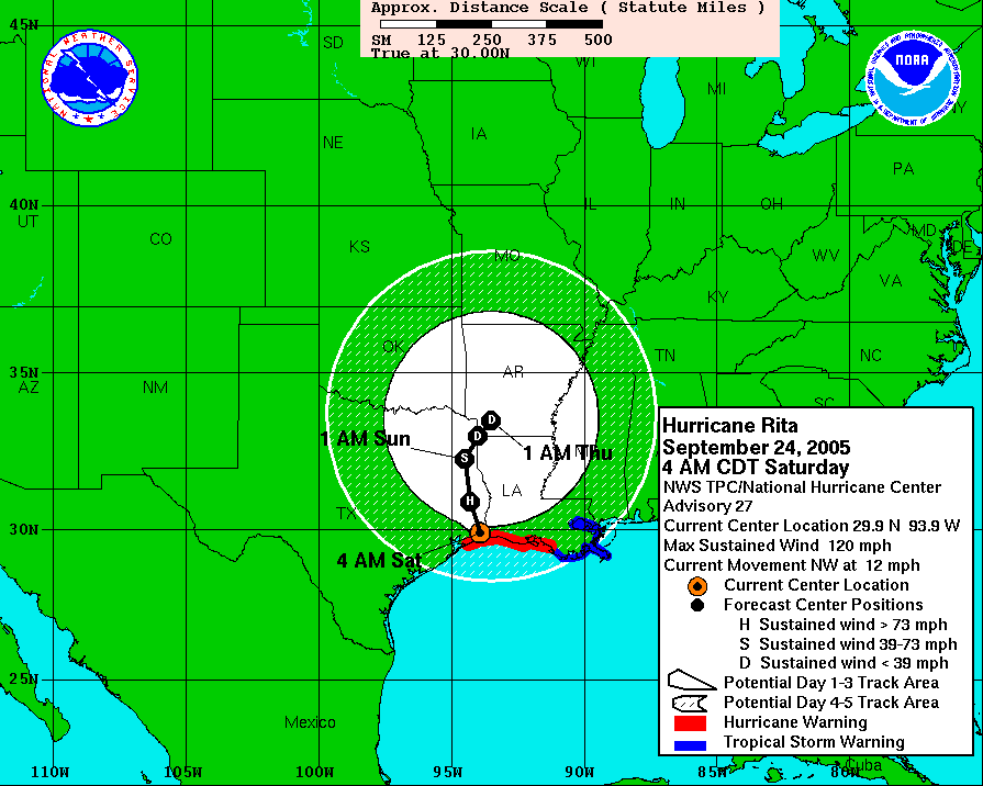
Rita:
http://www.nhc.noaa.gov/archive/2005/RI ... hics.shtml
I'm not seeing many similarities. By the time the 5 day hit the coast it was a matter of inching north and the landfall point never made it south of the central TX coast. When Ike's 5 day hit the coast it was central, then moved south and now, presumably, back north.
I post the following for entertainment purposes only.
Rita's landfall forecast:
5 days
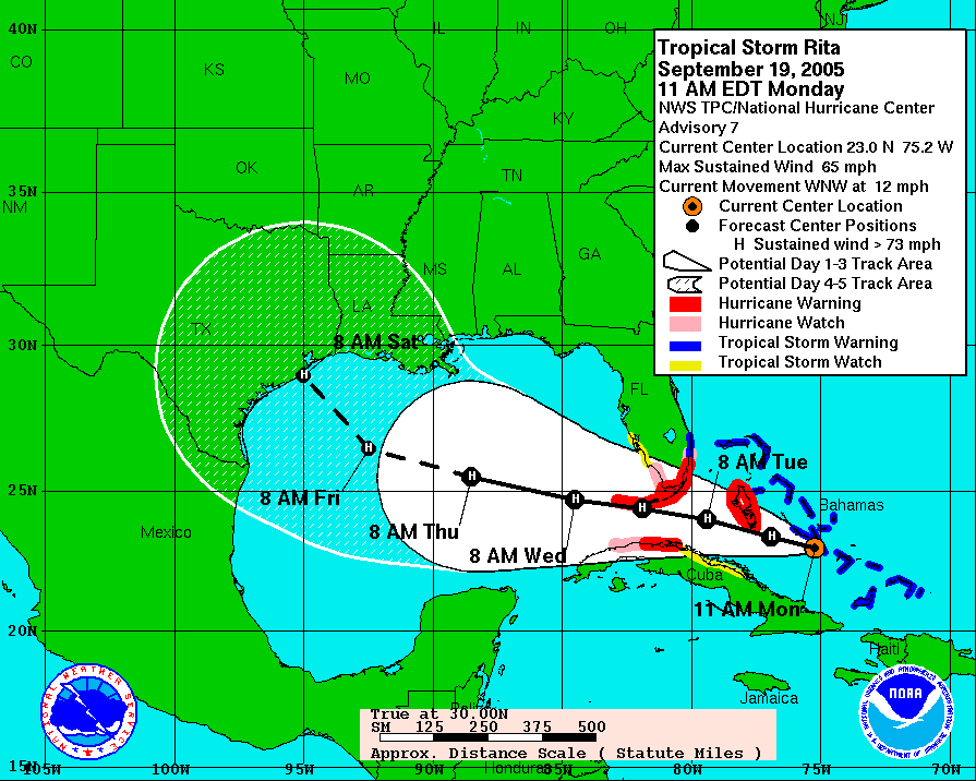
3 days
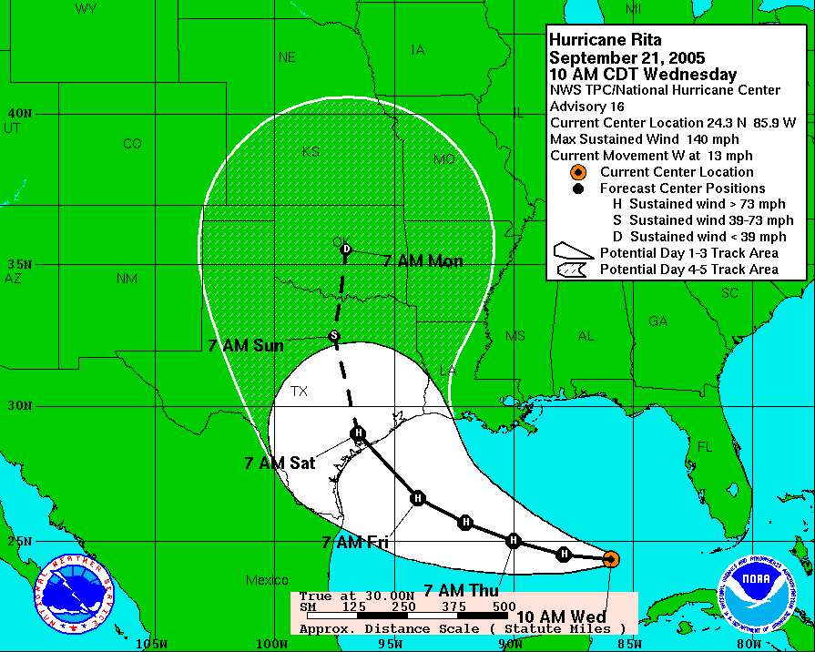
Actual
Ike:
5 days
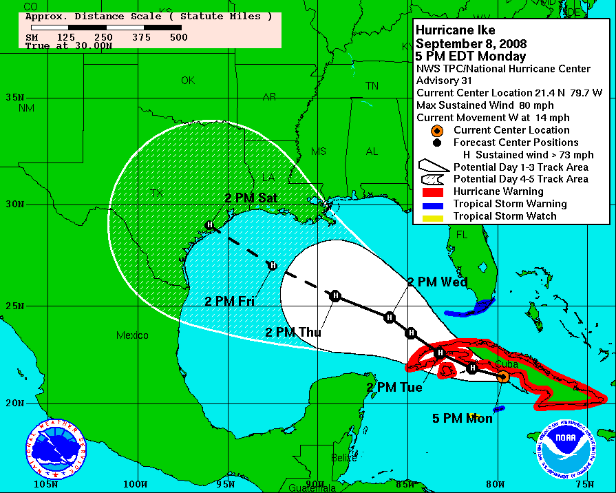
Current Forecast:
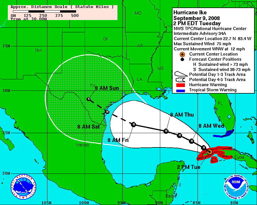
http://www.nhc.noaa.gov/archive/2005/RI ... hics.shtml
I'm not seeing many similarities. By the time the 5 day hit the coast it was a matter of inching north and the landfall point never made it south of the central TX coast. When Ike's 5 day hit the coast it was central, then moved south and now, presumably, back north.
I post the following for entertainment purposes only.
Rita's landfall forecast:
5 days
3 days
Actual
Ike:
5 days
Current Forecast:
Last edited by tolakram on Tue Sep 09, 2008 3:14 pm, edited 1 time in total.
0 likes
-
gboudx

- S2K Supporter
- Posts: 4090
- Joined: Thu Sep 04, 2003 1:39 pm
- Location: Rockwall, Tx but from Harvey, La
Re: ATL IKE: Models Discussion
Duddy wrote:dwg71 wrote:Comanche wrote:4/3.5/2 for sale, Clear Lake Texas. Great schools. Seller motivated, needs to close by this Friday!
No need to panic yet, A landfall point is not at possible now.
It all depends on timing, trough, high pressure, erosion of ridge, track, intensity, what Ed wants
Yeah but if landfall is still on for Saturday, then mandatory evacuations should be issued tomorrow. It's getting too late to play it by day.
From what Lidner said in his conference call, the onset of tropical storm force winds would arrive Friday afternoon. Which means Galv would have to start evacuations Wed by noon. And that maxes out the 36 hours required to evacuate them with no room for error. Cutting it close is an understatement.
0 likes

Who is online
Users browsing this forum: No registered users and 14 guests