ATL IKE: Models Discussion

Moderator: S2k Moderators

Message
Author
pablolopez26
Tropical Storm
Tropical Storm
Posts: 137
Joined: Wed Aug 27, 2008 5:10 pm

Re:

#3841 Postby pablolopez26 » Wed Sep 10, 2008 2:16 pm

Extremeweatherguy wrote:Ike is starting to remind me of another famous September Hurricane...


The final track and landfall strength of Ike may wind up being pretty darn close to what happened 108 years ago, IMO.

The posts in this forum are NOT official forecast and should not be used as such. They are just the opinion of the poster and may or may not be backed by sound meteorological data. They are NOT endorsed by any professional institution or storm2k.org. For official information, please refer to the NHC and NWS products.


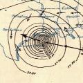
Amazing graphic. I think the Houston/Galveston area is obviously more prepared than it was back in the 1900's, either way though, Houston is going to get lots of flooding and lots of damage due to downed trees and powerlines.

I just hope the electricity is not going to go out for a long time. That would suck.

Guys, also remember to charge your cellphones before the power goes out! Please!
0 likes   

User avatar
Steve
S2K Supporter
S2K Supporter
Posts: 9621
Joined: Sat Apr 05, 2003 11:41 pm
Location: Not a state-caster

#3842 Postby Steve » Wed Sep 10, 2008 2:25 pm

>>I just hope the electricity is not going to go out for a long time. That would suck.

While it does indeed, suck, there are cherry pickers and utility guys all over the place about 5 hours east of there right now. On one 4 mile stretch of highway on Saturday, there were over 40 utility pole trucks. That was about 5 miles north of my house. We had power back by Sunday (which admittedly was 6 days, but not the end of the world). There are also Sheriff's all the way from places as distant as Walton County, Florida to South Dakota currently cruising in Lafourche Parish. There are also hundreds of EMT people and ambulances from everywhere that are already mobilized and ready to help you guys out like they were to help us out. Just don't expect FEMA to be ready with the ice and water. Freeze gallon jugs today to give you some extra cooling capacity. Move those jugs into your refrigerator and replace them with more jugs to freeze until both coolers are full of frozen or ice-cold water jugs. This may help save some of your perishables.

*edit* - Yikes, got caught up in the model thread. Looks like the SMWFD early runs are in line for a Central-North Central SE Texas strike - as of now of course.

http://xlr8.sfwmd.gov/portal/page?_page ... ema=PORTAL

Steve
0 likes   

User avatar
srainhoutx
S2K Supporter
S2K Supporter
Posts: 6919
Age: 67
Joined: Sun Jan 14, 2007 11:34 am
Location: Haywood County, NC
Contact:

Re: ATL IKE: Models Discussion

#3843 Postby srainhoutx » Wed Sep 10, 2008 2:26 pm

Air Force Met wrote:
Wx_Warrior wrote:12z EURO is nearly the same as 0z....Looks like Matagorda.

http://www.meteo.psu.edu/~gadomski/ECMWF_12z/ecmwfloop.html

EDIT: put it on 00....Why did EURO initialize Ike over Western Cuba?


Euro is not the same. Last run was W Matagorda bay. This run is over central Matagorda county.


Your thoughts along with wxman57 are looking more likely. I hope folks in SE TX/SW LA have taken this cyclone seriously.
0 likes   

User avatar
A1A
Tropical Storm
Tropical Storm
Posts: 156
Joined: Mon Oct 17, 2005 1:03 pm
Location: Central Texas

Re: ATL IKE: Models Discussion

#3844 Postby A1A » Wed Sep 10, 2008 2:48 pm

So generally anybody have any ideas on how much weight NHC will put on the GFDL run? It's getting down to the wire.
0 likes   

User avatar
lost cause
Tropical Low
Tropical Low
Posts: 24
Age: 48
Joined: Thu Aug 24, 2006 6:24 pm
Location: Galveston

Re: ATL IKE: Models Discussion

#3845 Postby lost cause » Wed Sep 10, 2008 2:52 pm

Speaking for the wife and myself, we're taking it seriously here. We don't like the fact that the tracks are still nudging to the right and with less than 48 hours to go, it wouldn't be impossible for this system to take a right hand shift that might impact Galveston Island more than expected. The conditions that have been predicted for a Matagorda Bay landfall are gonna be kinda rough to begin with. I wouldn't wanna see a more right of track strike, like either the Euro or the GFDL.

We're pulling out tonight sometime and heading to a relative's place in Baton Rouge. As for others, we know of someone else who's getting out and that's about it.
0 likes   

Stratosphere747
Category 5
Category 5
Posts: 3772
Joined: Thu Sep 11, 2003 8:34 pm
Location: Surfside Beach/Freeport Tx
Contact:

Re: ATL IKE: Models Discussion

#3846 Postby Stratosphere747 » Wed Sep 10, 2008 2:54 pm

A1A wrote:So generally anybody have any ideas on how much weight NHC will put on the GFDL run? It's getting down to the wire.


You will find out in about an hour. ;)

No question they will make mention of it in the upcoming discussion.
0 likes   

User avatar
perk
Category 3
Category 3
Posts: 825
Joined: Mon Aug 09, 2004 9:35 am
Location: Richmond Texas

Re:

#3847 Postby perk » Wed Sep 10, 2008 3:14 pm

dwg71 wrote:UKMET is moved pretty significantly south, nearly south of NHC track. If he gets moving, like expected, Corpus to Matagorda is the current consensous. Actually NHC is the northern outlier at land fall atm. Sans BAMM BAMMS & CMC

Image


I just looked at the 12z ukmet and it does'nt look to be south of the (NHC FORECAST)
0 likes   

User avatar
deltadog03
Professional-Met
Professional-Met
Posts: 3580
Joined: Tue Jul 05, 2005 6:16 pm
Location: Macon, GA

#3848 Postby deltadog03 » Wed Sep 10, 2008 3:28 pm

The track should go east at 5p...I don't know why they wouldn't
0 likes   

User avatar
MONTEGUT_LA
Tropical Storm
Tropical Storm
Posts: 105
Joined: Sun Jul 20, 2003 7:29 pm
Location: Montegut, Louisiana

Re:

#3849 Postby MONTEGUT_LA » Wed Sep 10, 2008 3:36 pm

Steve wrote:>>I just hope the electricity is not going to go out for a long time. That would suck.

While it does indeed, suck, there are cherry pickers and utility guys all over the place about 5 hours east of there right now. On one 4 mile stretch of highway on Saturday, there were over 40 utility pole trucks. That was about 5 miles north of my house. We had power back by Sunday (which admittedly was 6 days, but not the end of the world). There are also Sheriff's all the way from places as distant as Walton County, Florida to South Dakota currently cruising in Lafourche Parish. There are also hundreds of EMT people and ambulances from everywhere that are already mobilized and ready to help you guys out like they were to help us out. Just don't expect FEMA to be ready with the ice and water. Freeze gallon jugs today to give you some extra cooling capacity. Move those jugs into your refrigerator and replace them with more jugs to freeze until both coolers are full of frozen or ice-cold water jugs. This may help save some of your perishables.

*edit* - Yikes, got caught up in the model thread. Looks like the SMWFD early runs are in line for a Central-North Central SE Texas strike - as of now of course.

http://xlr8.sfwmd.gov/portal/page?_page ... ema=PORTAL

Steve


Same here, I am still without lights although they are working on it! Hot and Muggy! Ike needs to stay away. No one down here needs flooding or rain. We have many homes without a roof.
0 likes   

attallaman

Re: ATL IKE: Models Discussion

#3850 Postby attallaman » Wed Sep 10, 2008 3:38 pm

There's no chance of the models making a drastic shift to the E posing a serious threat to the C/GOM region is there?
0 likes   

Nederlander
S2K Supporter
S2K Supporter
Posts: 1250
Joined: Sat Jul 19, 2008 4:28 pm
Location: Conroe, TX

Re: ATL IKE: Models Discussion

#3851 Postby Nederlander » Wed Sep 10, 2008 3:41 pm

attallaman wrote:There's no chance of the models making a drastic shift to the E posing a serious threat to the C/GOM region is there?


no... at least not for now... doubtful itll happen
0 likes   

rtd2
Category 5
Category 5
Posts: 1183
Joined: Tue Aug 12, 2003 12:45 pm
Location: Biloxi, MS

Re: ATL IKE: Models Discussion

#3852 Postby rtd2 » Wed Sep 10, 2008 3:41 pm

attallaman wrote:There's no chance of the models making a drastic shift to the E posing a serious threat to the C/GOM region is there?


negative...i need good weather all weekend! :D
0 likes   

dwg71
Category 5
Category 5
Posts: 2349
Joined: Wed Jun 08, 2005 4:34 pm

#3853 Postby dwg71 » Wed Sep 10, 2008 3:42 pm

best chance for Houston is a strong HP and a cut off trough.

that would send it more to the west.

Or, huge butt shear, not going to happen. :oops:
0 likes   

User avatar
jasons2k
Storm2k Executive
Storm2k Executive
Posts: 8245
Age: 51
Joined: Wed Jul 06, 2005 12:32 pm
Location: The Woodlands, TX

#3854 Postby jasons2k » Wed Sep 10, 2008 3:44 pm

Models. thread. thank. you.
0 likes   

User avatar
A1A
Tropical Storm
Tropical Storm
Posts: 156
Joined: Mon Oct 17, 2005 1:03 pm
Location: Central Texas

Re: ATL IKE: Models Discussion

#3855 Postby A1A » Wed Sep 10, 2008 4:05 pm

NHC - not much of a shift as far as the coast

Image
0 likes   

dwg71
Category 5
Category 5
Posts: 2349
Joined: Wed Jun 08, 2005 4:34 pm

#3856 Postby dwg71 » Wed Sep 10, 2008 4:09 pm

Most models have it beginning a north turn inland. It will all depend how strong high pressure is and can it steer it closer to W, than NW. Weaker HP, more wnw motion and earlier curve.

Any deviations from track should amplify the land fall positions.
0 likes   

hurrican19
Tropical Storm
Tropical Storm
Posts: 153
Joined: Sun Jun 13, 2004 1:36 pm
Location: Northwest Austin, TX

#3857 Postby hurrican19 » Wed Sep 10, 2008 4:21 pm

Almost getting too late to call evacuations for the GLS/HOU/BPT/LCH areas if needed....
0 likes   

Nederlander
S2K Supporter
S2K Supporter
Posts: 1250
Joined: Sat Jul 19, 2008 4:28 pm
Location: Conroe, TX

Re:

#3858 Postby Nederlander » Wed Sep 10, 2008 4:28 pm

hurrican19 wrote:Almost getting too late to call evacuations for the GLS/HOU/BPT/LCH areas if needed....


24-48 hours is ample time for the Golden Triangle
0 likes   

rtd2
Category 5
Category 5
Posts: 1183
Joined: Tue Aug 12, 2003 12:45 pm
Location: Biloxi, MS

Re: Re:

#3859 Postby rtd2 » Wed Sep 10, 2008 4:36 pm

Nederlander wrote:
hurrican19 wrote:Almost getting too late to call evacuations for the GLS/HOU/BPT/LCH areas if needed....


24-48 hours is ample time for the Golden Triangle


agree I would say by 8am
0 likes   

dwg71
Category 5
Category 5
Posts: 2349
Joined: Wed Jun 08, 2005 4:34 pm

#3860 Postby dwg71 » Wed Sep 10, 2008 4:36 pm

18z GFS initialized pretty accurate to position..

lets see what comes of it.

Through 72 slightly slower, landfall seems to be in same central coast vicinity :)
Image
Last edited by dwg71 on Wed Sep 10, 2008 5:00 pm, edited 6 times in total.
0 likes   


Return to “2008”

Who is online

Users browsing this forum: No registered users and 6 guests