ATL IKE: TCI/Bahamas/Cuba/Florida preps/obs/reports

This is the general tropical discussion area. Anyone can take their shot at predicting a storms path.

Moderator: S2k Moderators

Forum rules

The posts in this forum are NOT official forecasts and should not be used as such. They are just the opinion of the poster and may or may not be backed by sound meteorological data. They are NOT endorsed by any professional institution or STORM2K. For official information, please refer to products from the National Hurricane Center and National Weather Service.

Help Support Storm2K
Message
Author
User avatar
msbee
S2K Supporter
S2K Supporter
Posts: 3027
Joined: Wed Jun 11, 2003 10:11 am
Location: St. Maarten

Re: ATL IKE: TCI/Bahamas/Cuba/Florida preps/obs/reports

#61 Postby msbee » Tue Sep 09, 2008 5:01 pm

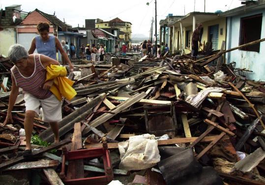
here are some pictures of the damage in Cuba. :cry:

Image

Image

Image

Image

Image
0 likes   

JonathanBelles
Professional-Met
Professional-Met
Posts: 11430
Age: 35
Joined: Sat Dec 24, 2005 9:00 pm
Location: School: Florida State University (Tallahassee, FL) Home: St. Petersburg, Florida
Contact:

#62 Postby JonathanBelles » Tue Sep 09, 2008 6:14 pm

Those wave pictures from Cuba are amazing. I couldnt imagine 50' waves.

Anyway, the local met was amazingly correct last night when he said that Ike would reach Tampa Bay at around 5pm today. Sure enough, the clouds came in around 430, and it was pouring by 5.
0 likes   

JonathanBelles
Professional-Met
Professional-Met
Posts: 11430
Age: 35
Joined: Sat Dec 24, 2005 9:00 pm
Location: School: Florida State University (Tallahassee, FL) Home: St. Petersburg, Florida
Contact:

#63 Postby JonathanBelles » Wed Sep 10, 2008 2:51 pm

I saw earlier that Shore Acres is completely flooded here in Pinellas County from storm surge. Also, people in Gulfport and people along the Brandon River in manatee county have flooding. Winds here are around 20mph, gusts higher.
0 likes   

User avatar
tronbunny
S2K Supporter
S2K Supporter
Posts: 1558
Joined: Wed Sep 01, 2004 1:18 am
Location: Central FL

Re: ATL IKE: TCI/Bahamas/Cuba/Florida preps/obs/reports

#64 Postby tronbunny » Wed Sep 10, 2008 5:10 pm

I cannot give a current flood status for the St. John's River Basin, but Florida does not get off free and clear.

Currently, South Central Florida, specifically Northwestern Osceola county is under a tornado watch.

Ike's reach is far and wide.

The direction and construct of this cell is clearly related to outflow.
There is some minor damage already reported.

This is nothing compared to what Ike has already done and will continue to.
It is eye-opening to get just this fragment and see how powerful this phenomenon is.
0 likes   

JonathanBelles
Professional-Met
Professional-Met
Posts: 11430
Age: 35
Joined: Sat Dec 24, 2005 9:00 pm
Location: School: Florida State University (Tallahassee, FL) Home: St. Petersburg, Florida
Contact:

#65 Postby JonathanBelles » Wed Sep 10, 2008 5:51 pm

St. Pete Beach (and probably other barrier islands) were also flooded today. The surge went down with the tides, but will go back up tomorrow so said the local met and NWS.
0 likes   

yzerfan
Category 2
Category 2
Posts: 588
Joined: Thu Sep 11, 2003 8:09 pm
Location: Niceville, FL

Re: ATL IKE: TCI/Bahamas/Cuba/Florida preps/obs/reports

#66 Postby yzerfan » Thu Sep 11, 2008 8:12 am

In the Panhandle, US 98 between Ft. Walton Beach and Destin is closed because of coastal flooding. It's one of the biggest commuter roads in the area.

http://www.nwfdailynews.com/news/okaloo ... ghway.html
0 likes   

r_u_stuck2
Tropical Low
Tropical Low
Posts: 40
Joined: Tue Sep 14, 2004 9:55 am
Location: Pensacola, Fl

Re: ATL IKE: TCI/Bahamas/Cuba/Florida preps/obs/reports

#67 Postby r_u_stuck2 » Thu Sep 11, 2008 10:15 am

Pensacola Beach Swamped. Island has been breached in two different places. Streets impassable.
http://www.pnj.com/apps/pbcs.dll/articl ... GECAROUSEL
0 likes   

NewOrleansMom
Tropical Low
Tropical Low
Posts: 17
Joined: Sun Aug 12, 2007 12:10 am
Location: WestBank of New Orleans

#68 Postby NewOrleansMom » Thu Sep 11, 2008 6:27 pm

New Orleans and lower East La. coastal areas have begun to feel the effects of Hurricane Ike. Conditions are expected to worsen throughout the night.

TROPICAL STORM WINDS HAVE ONSET ALONG THE LOWER LOUISIANA COAST AND WILL CONTINUE THROUGH FRIDAY MORNING. HIGH TIDES AND SALT WATER INUNDATION IS TAKING PLACE OUTSIDE THE HURRICANE LEVEE PROTECTION SYSTEM.

Wind of 35 to 45 MPH with gusts to 55 mph. mainly in squalls

ISOLATED TORNADOES MAINLY NEAR THE IMMEDIATE COAST ARE POSSIBLE IN SQUALLS THAT MAY BE MOVING ONSHORE FRIDAY.


http://www.weather.com/weather/alerts/l ... age=mypage

Good luck to our good friends in Texas. You are in our prayers.
0 likes   

JonathanBelles
Professional-Met
Professional-Met
Posts: 11430
Age: 35
Joined: Sat Dec 24, 2005 9:00 pm
Location: School: Florida State University (Tallahassee, FL) Home: St. Petersburg, Florida
Contact:

#69 Postby JonathanBelles » Thu Sep 11, 2008 10:38 pm

Just went outside for a minute: Cirrostratus clouds with an amazing lunar effect. A HUGE ring around the moon, probably takes up a third of the sky.

Had flooding again today around Pinellas County.
0 likes   

JonathanBelles
Professional-Met
Professional-Met
Posts: 11430
Age: 35
Joined: Sat Dec 24, 2005 9:00 pm
Location: School: Florida State University (Tallahassee, FL) Home: St. Petersburg, Florida
Contact:

#70 Postby JonathanBelles » Fri Sep 12, 2008 11:45 am

A plane nearly had an early landing last night at the St. Pete/Clearwater. It landed on the runway, but had problems keeping on it. All due to strong gusts.

Here is a story about the flooding here in Pinellas from the St. Petersburg Times: http://www.tampabay.com/news/weather/hu ... 807199.ece
0 likes   


Return to “Talkin' Tropics”

Who is online

Users browsing this forum: 7cardinal, AnnularCane, Blown Away, Cpv17, Google Adsense [Bot], Lizzytiz1, ScottNAtlanta, TampaWxLurker, TomballEd, wxman57 and 60 guests