
REGARDLESS OF WHERE THE CENTER
CROSSES THE COAST...THE EFFECTS OF IKE WILL BE FELT OVER A LARGE
AREA.
ATL: IKE Discussion
Moderator: S2k Moderators
-
LSU2001

- S2K Supporter

- Posts: 1711
- Age: 58
- Joined: Sat Sep 11, 2004 11:01 pm
- Location: Cut Off, Louisiana
Re: ATL IKE: Category 2 - Discussion
Ed Mahmoud wrote:Something seems to be eroding the deeper convection West of the center. Dry air, perhaps?
Looks like a little dry slot Ed.

0 likes


Re:
deltadog03 wrote:BTW....The ridge off the SE coast actually shunted EAST tonight....I am not saying this will be perminant, but its not moving W right now.
What models, so far, have taken this "easterly shunt" into consideration?? Any??
0 likes
Re: ATL IKE: Category 2 - Discussion
MiamiensisWx wrote:Ixolib wrote:Fortunately, though, the damage was superficial - not structural. Quick and easy to fix. Looks bad - and would BE bad if you get sliced by a piece of falling glass.jinftl wrote:Skyscrapers in Ft. Lauderdale had their windows blown out from sustained borderline cat 1/2 winds in Wilma. I'd hate to see the result of Houston's dealing with even marginal cat 3 winds.
Generally speaking, structures "closer to the ground" do just fine in most cases, even in cat 3/4 winds. Sure, they take a hit with the wind, but for the most part, they remain structurally sound. Again, quick and easy to fix. This, of course, is not including tornados and mini-vortices. With those, all bets are off!!
But surge is a whole different beast. Not quick to fix, not easy to fix, renders most structures it enters to be inhabitable, and often times, condemed.
While Wilma did her deed, much of her damage was not to a point where it rendered dwellings "structurally" impaired because her impact was primarily wind only. If surge had been an issue with Wilma, she'd still be in the news today!!!
Hide from the wind, but run from the water...
Andrew, Hugo, Dean, Felix, and Janet survivors would beg to differ with that statement if they resided in poorly constructed structures. Even well constructed structures received wind damage during these TCs, though they remained intact during the ordeals. Keep in mind that the costs for replacements/addendums due to wind damage (including broken windows, lost tiles, etc.) are significant as well.
I think it is dangerous to downplay surge AND wind... strong TS/Cat 1 winds can cause significant structural damage to unsound/poorly constructed buildings/residences.
I know all storms have their own personality, but the ones I've been through (including a strong Cat 3 direct hit) did not cause widespread structural damage due simply to wind.
0 likes
-
Matt-hurricanewatcher
Re: ATL IKE: Category 2 - Discussion
CronkPSU wrote:Matt-hurricanewatcher wrote:The records are kepted for the size of tropical storm force winds, so Ike is now the size of Katrina with Tropical storm force winds 230 nmi's. Hurricane force, Ike is still 10 nmi smaller then Katrina.
you mean when Katrina was in this area of the gulf or at her peak?
When she made landfall on MS. When she was starting to weaken and the wind field was at her widest.
0 likes

Re: ATL IKE: Category 2 - Discussion
Ixolib wrote:I've always wondered why people who choose to live in hurricane prone areas think it's okay to live in poorly constructed structures.
I doubt anyone thinks it's okay to live in poorly-constructed houses. It's a matter of what you can afford - look at all those who chose to live in well-constructed homes... and were forced out, not by a hurricane, but by foreclosure. And then there are those who believe that their homes, being expensive, are well-constructed, but they're not. There was a big write-up in the St. Pete Times about this several years ago.
As for these questions about northern movement, I think some of it's from tv. They're at it again, really emphasizing it. Something about a 2nd trough and "models trending further north." But whether it tracks a bit north of where they think or not, Ike is going to impact a huge swath of Texas, and looks like a devastating storm. It must be horrible, watching this thing approach.
edited for missing word... again
Last edited by Sihara on Wed Sep 10, 2008 10:12 pm, edited 1 time in total.
0 likes
-
Sabanic

- Category 2

- Posts: 683
- Age: 66
- Joined: Wed Aug 01, 2007 7:01 am
- Location: Mobile, AL
- Contact:
Re: Re:
Ixolib wrote:deltadog03 wrote:BTW....The ridge off the SE coast actually shunted EAST tonight....I am not saying this will be perminant, but its not moving W right now.
What models, so far, have taken this "easterly shunt" into consideration?? Any??
None that I can recall. None at all. That was supposed to closed up pretty much by now.
0 likes
-
deltadog03

- Professional-Met

- Posts: 3580
- Joined: Tue Jul 05, 2005 6:16 pm
- Location: Macon, GA
Re: Re:
Sabanic wrote:Ixolib wrote:deltadog03 wrote:BTW....The ridge off the SE coast actually shunted EAST tonight....I am not saying this will be perminant, but its not moving W right now.
What models, so far, have taken this "easterly shunt" into consideration?? Any??
None that I can recall. None at all. That was supposed to closed up pretty much by now.
I went back and wanted to see how that opening did today and it actually nearly closed, but now is about as apart as when we started the day.
0 likes
-
ConvergenceZone
.gif)
- Category 5

- Posts: 5241
- Joined: Fri Jul 29, 2005 1:40 am
- Location: Northern California
Re: ATL IKE: Category 2 - Discussion
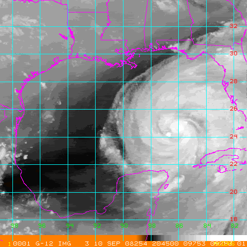
Hmm, anyone read the latest NHC discussion just released where it says that Ike may actually weaken over the next 24 hours??? Strange...Guess it has to do with that inner eye.....So I guess are eyes haven't been deceiving us regarding our comments about Ike not looking that healthy on satellite...
0 likes
-
6SpeedTA95
- Category 5
- Posts: 1206
- Joined: Wed Oct 19, 2005 3:25 pm
- Location: Oklahoma
- Contact:
Re: ATL IKE: Category 2 - Discussion
ConvergenceZone wrote:Hmm, anyone read the latest discussion where it says that Ike may actually weaken over the next 24 hours??? Strange...Guess it has to do with that inner eye.....So I guess are eyes haven't been deceiving us regarding our comments about Ike not looking that healthy on satellite...
Air has been dry basically all day and much of yesterday evening, Derek said yesterday he felt it would be slow to strengthen while the eye situation sorted itself out.
0 likes
-
mvtrucking

- S2K Supporter
- Posts: 698
- Age: 67
- Joined: Sat Jul 09, 2005 10:01 am
- Location: Monroe,La
Re: Re:
[/quote]
I went back and wanted to see how that opening did today and it actually nearly closed, but now is about as apart as when we started the day.[/quote]
___________________________________________________________________________________________________________-_____
IF that weakness(opening) continues to not close, what type effect on track, if any? I guess that would be a million dollar question.
0 likes
-
cheezyWXguy

- Category 5
- Posts: 6282
- Joined: Mon Feb 13, 2006 12:29 am
- Location: Dallas, TX
Re: ATL IKE: Category 2 - Discussion
ConvergenceZone wrote:Hmm, anyone read the latest NHC discussion just released where it says that Ike may actually weaken over the next 24 hours??? Strange...Guess it has to do with that inner eye.....So I guess are eyes haven't been deceiving us regarding our comments about Ike not looking that healthy on satellite...
Nope...it has a pretty puny inner core right now, and likely wont strengthen much until the outer eyewall takes over and contracts. How big do you all think the new eye will be?-directed more towards pro mets
0 likes
Re: ATL IKE: Category 2 - Discussion
ConvergenceZone wrote:Hmm, anyone read the latest NHC discussion just released where it says that Ike may actually weaken over the next 24 hours??? Strange...Guess it has to do with that inner eye.....So I guess are eyes haven't been deceiving us regarding our comments about Ike not looking that healthy on satellite...
They cite the cold water eddy as one reason, and the possible collapse of the small inner core.
Personal Forecast Disclaimer:
The posts in this forum are NOT official forecast and should not be used as such. They are just the opinion of the poster and may or may not be backed by sound meteorological data. They are NOT endorsed by any professional institution or storm2k.org. For official information, please refer to the NHC and NWS products.[/quote]
If Ike doesn't get himself together by tomorrow, I don't know that he'll make cat 3.
0 likes
-
6SpeedTA95
- Category 5
- Posts: 1206
- Joined: Wed Oct 19, 2005 3:25 pm
- Location: Oklahoma
- Contact:
Re: Re:
mvtrucking wrote:
I went back and wanted to see how that opening did today and it actually nearly closed, but now is about as apart as when we started the day.[/quote]
___________________________________________________________________________________________________________-_____
IF that weakness(opening) continues to not close, what type effect on track, if any? I guess that would be a million dollar question.[/quote]
IF and its a HUGE IF, the weakness doesn't close the storm takes the path of least resistence...it follows the weakness.
0 likes
-
Derek Ortt
-
cheezyWXguy
- Category 5
- Posts: 6282
- Joined: Mon Feb 13, 2006 12:29 am
- Location: Dallas, TX
Re: ATL IKE: Category 2 - Discussion
dhweather wrote:ConvergenceZone wrote:Hmm, anyone read the latest NHC discussion just released where it says that Ike may actually weaken over the next 24 hours??? Strange...Guess it has to do with that inner eye.....So I guess are eyes haven't been deceiving us regarding our comments about Ike not looking that healthy on satellite...
They cite the cold water eddy as one reason, and the possible collapse of the small inner core.
Personal Forecast Disclaimer:
The posts in this forum are NOT official forecast and should not be used as such. They are just the opinion of the poster and may or may not be backed by sound meteorological data. They are NOT endorsed by any professional institution or storm2k.org. For official information, please refer to the NHC and NWS products.
If Ike doesn't get himself together by tomorrow, I don't know that he'll make cat 3.[/quote]
Youll be surprised. Once it gets that core together, this thing will probably jump straight to cat4.
0 likes
-
superdeluxe
- Tropical Low

- Posts: 36
- Joined: Wed Aug 02, 2006 11:29 am
-
ConvergenceZone
- Category 5
- Posts: 5241
- Joined: Fri Jul 29, 2005 1:40 am
- Location: Northern California
Re: ATL IKE: Category 2 - Discussion
cheezyWXguy wrote:ConvergenceZone wrote:Hmm, anyone read the latest NHC discussion just released where it says that Ike may actually weaken over the next 24 hours??? Strange...Guess it has to do with that inner eye.....So I guess are eyes haven't been deceiving us regarding our comments about Ike not looking that healthy on satellite...
Nope...it has a pretty puny inner core right now, and likely wont strengthen much until the outer eyewall takes over and contracts. How big do you all think the new eye will be?-directed more towards pro mets
Yea, I noticed that now their intensification map doesn't show a cat 3 until sometime on Friday whereas the update before showed a cat 3 tomorrow morning. So they think it will be over 24 hours before this hits cat3 status....so looks like they must be figuring in the weakening...
0 likes
Who is online
Users browsing this forum: No registered users and 12 guests