ATL: IKE Discussion

Moderator: S2k Moderators

Message
Author
User avatar
artist
Category 5
Category 5
Posts: 9792
Joined: Mon Jun 06, 2005 3:26 pm
Location: West Palm

Re: ATL IKE: Category 2 - Discussion

#8601 Postby artist » Thu Sep 11, 2008 1:20 am

I-wall wrote:Does anyone know when the updated forecast track comes out? Is it 5 am eastern time? Also, any idea on what the latest model runs looked like? I'm trying to figure out if the forecast will shift further east again. Thanks.


Welcome and here is the last page of the models thread. They should be able to answer your questions over there -
viewtopic.php?f=59&t=102848&start=4020
0 likes   

I-wall
Tropical Storm
Tropical Storm
Posts: 210
Joined: Wed Sep 10, 2008 5:24 pm

Re: ATL IKE: Category 2 - Discussion

#8602 Postby I-wall » Thu Sep 11, 2008 1:23 am

artist wrote:
I-wall wrote:Does anyone know when the updated forecast track comes out? Is it 5 am eastern time? Also, any idea on what the latest model runs looked like? I'm trying to figure out if the forecast will shift further east again. Thanks.


Welcome and here is the last page of the models thread. They should be able to answer your questions over there -
viewtopic.php?f=59&t=102848&start=4020


Much appreciated. :D
0 likes   

Nexus
Tropical Storm
Tropical Storm
Posts: 137
Joined: Sat Sep 11, 2004 12:13 am

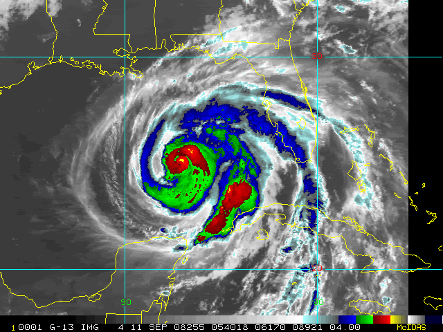
#8603 Postby Nexus » Thu Sep 11, 2008 1:24 am

New low-res G-13, but in color (05:40 UTC):

Image

Musta just got out of it's own eclipse, too bad as G-12 is almost out of eclipse.
Last edited by Nexus on Thu Sep 11, 2008 1:27 am, edited 1 time in total.
0 likes   

User avatar
Duddy
Category 1
Category 1
Posts: 363
Joined: Sat Jun 10, 2006 9:07 pm
Location: Wilmington, NC

Re:

#8604 Postby Duddy » Thu Sep 11, 2008 1:25 am

Nexus wrote:New low-res G-13, but in color (05:40 UTC):

Image


Man, hard to say if it will strengthen much before morning. Nice embryo shape, but man, looks alittle "sick". But I'm no met.
0 likes   

User avatar
Hurricanewatcher2007
Category 2
Category 2
Posts: 578
Joined: Sat Jul 05, 2008 8:10 pm

Re: ATL IKE: Category 2 - Discussion

#8605 Postby Hurricanewatcher2007 » Thu Sep 11, 2008 1:27 am

Looks to me like the outer eye wall is really starting to take over now! This microwave image was from 3:10Z which is after the others I posted a page or 2 back that showed a very disorganized outer eye-wall!

Image
0 likes   

dwg71
Category 5
Category 5
Posts: 2349
Joined: Wed Jun 08, 2005 4:34 pm

#8606 Postby dwg71 » Thu Sep 11, 2008 1:30 am

i wonder if recon will find anything to justify cat 2 status...

i think its more like 80 mph than 100, just my two cents and limited recon data.
0 likes   

User avatar
Hurricanewatcher2007
Category 2
Category 2
Posts: 578
Joined: Sat Jul 05, 2008 8:10 pm

Re:

#8607 Postby Hurricanewatcher2007 » Thu Sep 11, 2008 1:35 am

dwg71 wrote:i wonder if recon will find anything to justify cat 2 status...

i think its more like 80 mph than 100, just my two cents and limited recon data.


Well they just found 86kt flight level winds which support 90mph and thats not even near the center.
Last edited by Hurricanewatcher2007 on Thu Sep 11, 2008 1:58 am, edited 2 times in total.
0 likes   

User avatar
opera ghost
Category 4
Category 4
Posts: 909
Joined: Mon Sep 08, 2003 4:40 pm
Location: Houston, Texas

Re:

#8608 Postby opera ghost » Thu Sep 11, 2008 1:37 am

JenBayles wrote:I went to the HEB on Hiway 6 North around 7:30 tonight, figuring most people who stopped in after work would be gone. Wrong! The bread was gone, and serious dents being made in water, soft drinks, canned goods, pet food, etc. Plenty of Coronas though at 12.99 so I stocked up! ;-)

I bet tomorrow will be totally crazy at the grocery stores here in Houston, and although it was pretty darn busy tonight, it was still bearable. I've run my last errand so whatever happens... happens.


Hopped down to a Kroger inside the 610 loop (WestU area) around 10:30 and compared to the usual 10pm+ traffic (best time to go grocery shopping!) it was a zoo. Not as bad as the day before thanksgiving though- I'm glad I went this early. Tomorrow promises to be crazy. The stock boys were wheeling out flats of water and it was vanishing pretty fast- the water aisle consistently had 5+ people picking through what was left on the shelves/flats. I did find it hilarious that the shelves were bare of canned tuna. I guess everyone else shared my idea!
0 likes   

Nexus
Tropical Storm
Tropical Storm
Posts: 137
Joined: Sat Sep 11, 2004 12:13 am

#8609 Postby Nexus » Thu Sep 11, 2008 1:51 am

Looping the images from the last several hours at the Navy site, it seems Ike is growing in size:

http://www.nrlmry.navy.mil/tc_pages/tc0 ... atest.html
0 likes   

fasterdisaster
Category 5
Category 5
Posts: 1868
Joined: Mon Sep 19, 2005 4:41 pm
Location: Miami, Florida

Re:

#8610 Postby fasterdisaster » Thu Sep 11, 2008 1:53 am

dwg71 wrote:i wonder if recon will find anything to justify cat 2 status...

i think its more like 80 mph than 100, just my two cents and limited recon data.


90 kts flight level, Ike is probably still 100 mph.
0 likes   

fasterdisaster
Category 5
Category 5
Posts: 1868
Joined: Mon Sep 19, 2005 4:41 pm
Location: Miami, Florida

#8611 Postby fasterdisaster » Thu Sep 11, 2008 1:53 am

How many hours should it be before the inner eyewall disappears? 6?
0 likes   

fasterdisaster
Category 5
Category 5
Posts: 1868
Joined: Mon Sep 19, 2005 4:41 pm
Location: Miami, Florida

Re: Re:

#8612 Postby fasterdisaster » Thu Sep 11, 2008 1:55 am

fasterdisaster wrote:
dwg71 wrote:i wonder if recon will find anything to justify cat 2 status...

i think its more like 80 mph than 100, just my two cents and limited recon data.


90 kts flight level, Ike is probably still 100 mph.

Actually they found 93 kts I just saw, so he is definitely Category 2.
0 likes   

User avatar
Hurricanewatcher2007
Category 2
Category 2
Posts: 578
Joined: Sat Jul 05, 2008 8:10 pm

Re: ATL IKE: Category 2 - Discussion

#8613 Postby Hurricanewatcher2007 » Thu Sep 11, 2008 1:59 am

Note - this is not official and is just my own personal thoughts!

Ok here is what I expect to happen over the next 24 to 48 hours. Ike is clearly going through an eye-wall replacement cycle. I am basing this fact on many sources including recon data of a double wind maxima and Microwave images depicting the outer eye-wall. Over the course of the day today (9-11) I expect the outer eye-wall to completely take over and for the new larger eye to clear out by tonight. Through out the day today watch recon reports for weakening winds near the center and increasing winds around the outer wind maxima. Also watch the microwave data. Also Ike will be traveling over a cold eddy through out a good part of the day today after that the waters will be increasing in heat. Once the eye clears out it will continue to contract which will result in pressure falls and increases in wind speeds. I expect Ike will make landfall as a cat 3 or 4 Saturday morning between 5am and 6am. Storm surge of 10 to 15 feet above normal tides can be expected to the north of where the center makes landfall with 20+ foot waves on top of that. (Surge may have to be upgraded or downgraded based on actual strength at landfall.)

Today - Expect no large change in strength during the eye-wall replacement cycle. Ike may even weakening some in the short term until the ERC is completed!

This is a serious situation and SHOULD NOT be taking lightly. If you are in a flood prone area along the texas coast be prepared to evacuate when told to do so by your local law enforcement officials. Every thing to save life and property SHOULD BE RUSHED to completion. Because of Ike's large size condition could start going down hill as early as Friday morning.
Last edited by Hurricanewatcher2007 on Thu Sep 11, 2008 2:00 am, edited 1 time in total.
0 likes   

dwg71
Category 5
Category 5
Posts: 2349
Joined: Wed Jun 08, 2005 4:34 pm

#8614 Postby dwg71 » Thu Sep 11, 2008 2:00 am

just saw that, 95 mph at a 90 percent reduction.. is that what is used at this level or is it 85
0 likes   

User avatar
Duddy
Category 1
Category 1
Posts: 363
Joined: Sat Jun 10, 2006 9:07 pm
Location: Wilmington, NC

Re: ATL IKE: Category 2 - Discussion

#8615 Postby Duddy » Thu Sep 11, 2008 2:00 am

Well if the GFDL holds true, it says Ike will be a strong cat 3 within 6 hours.
0 likes   

User avatar
WxGuy1
Professional-Met
Professional-Met
Posts: 538
Joined: Sat Oct 22, 2005 12:55 pm
Location: Oklahoma

#8616 Postby WxGuy1 » Thu Sep 11, 2008 2:01 am

Yeah, still looks like some dry air may be inhibiting intensification and organization a bit (along with the double wind max structure). For example, note the patch of drier air in the western Gulf at Image

The dry air was evident as a wedge of much weaker convection on visible satellite earlier today. At this stage, Ike still has time to organize and intensify to Cat 4 status, but we shall see. The size of the TS-strength winds and the low central pressure may make the surge more a player than would otherwise be expected.
Last edited by WxGuy1 on Thu Sep 11, 2008 2:03 am, edited 1 time in total.
0 likes   

Evac3
Tropical Depression
Tropical Depression
Posts: 60
Joined: Sun Sep 23, 2007 1:59 pm
Location: Orange County, Southeast Texas

Re: ATL IKE: Category 2 - Discussion

#8617 Postby Evac3 » Thu Sep 11, 2008 2:02 am

You have GOT to be kidding me... TWC is gonna run "It Could Happen Tomorrow" with this hurricane two days away? What the heck?
0 likes   

Brent
S2K Supporter
S2K Supporter
Posts: 38091
Age: 36
Joined: Sun May 16, 2004 10:30 pm
Location: Tulsa Oklahoma
Contact:

Re: ATL IKE: Category 2 - Discussion

#8618 Postby Brent » Thu Sep 11, 2008 2:03 am

Eclipse over, you can see that dry slot on the west side:

Image
0 likes   

User avatar
Duddy
Category 1
Category 1
Posts: 363
Joined: Sat Jun 10, 2006 9:07 pm
Location: Wilmington, NC

Re: ATL IKE: Category 2 - Discussion

#8619 Postby Duddy » Thu Sep 11, 2008 2:04 am

OK, I'll go to bed if someone answers this with atleast SOME confidence.

Since the models have converged again on Matagorda, do you expect the NHC track to shift back down the coast? Because only one model takes it near Galveston.

The 5AM track determines whether or not I leave.
0 likes   

dwg71
Category 5
Category 5
Posts: 2349
Joined: Wed Jun 08, 2005 4:34 pm

#8620 Postby dwg71 » Thu Sep 11, 2008 2:07 am

duddy, its already near matagorda. i would not expect and change in path.. landfall just north of matagorda bay
0 likes   


Return to “2008”

Who is online

Users browsing this forum: No registered users and 2 guests