ATL: IKE Discussion
Moderator: S2k Moderators
-
Hurricanewatcher2007

- Category 2

- Posts: 578
- Joined: Sat Jul 05, 2008 8:10 pm
Re:
mattpetre wrote:Recon thread showing 102 and 103 kt measurements... Is he a Cat 3 now?
No Ike is not a cat 3 yet. This is a noaa plane that are finding these winds they are flying higher then the Airforce flights I believe there for I am pretty sure it would be a .8 reduction which would mean it would be about 82.4kts surface winds. Can a pro-met correct me if I am wrong?
0 likes
-
Dean4Storms
- S2K Supporter

- Posts: 6358
- Age: 63
- Joined: Sun Aug 31, 2003 1:01 pm
- Location: Miramar Bch. FL
-
carversteve

- Tropical Storm

- Posts: 161
- Joined: Sat Aug 18, 2007 7:40 am
Re: Re:
Derek Ortt wrote:ConvergenceZone wrote:HouTXmetro wrote:Although not likely , could Ike suprise us and Hit Cat 4 Status?
Extremely doubtful for a cat4 now. It's just not that type of system and once the outflow gets over land it will choke it off a bit anyway...If it can't get it's act together now, I don't see how it will do it later.
this can go from a 2 to a 4 very quickly once this eyewall struff finally ceases
Ahhhhh......A voice of reason,especially after all the talk about no way Ike will make it to cat 4 this morning..Thanks Derek!! People still need to treat this as it could become a cat 4,even if it doesn't!!
0 likes

I'm going to take a big guess and say that Ike will remain about the same up to landfall - too much dry air to the north and west of the system...
As the NHC said, Ike is a bit of a anomaly since the pressure is very low but the winds are not very high, so, so far so good...
I just wish TWC would stop repeating those "packing up and getting out" film bites every hour - hopefully it will not be necessary, for anyone other than on Galveston Island...
Frank
0 likes
-
Hurricanewatcher2007
- Category 2
- Posts: 578
- Joined: Sat Jul 05, 2008 8:10 pm
Re: ATL IKE: Category 2 - Discussion
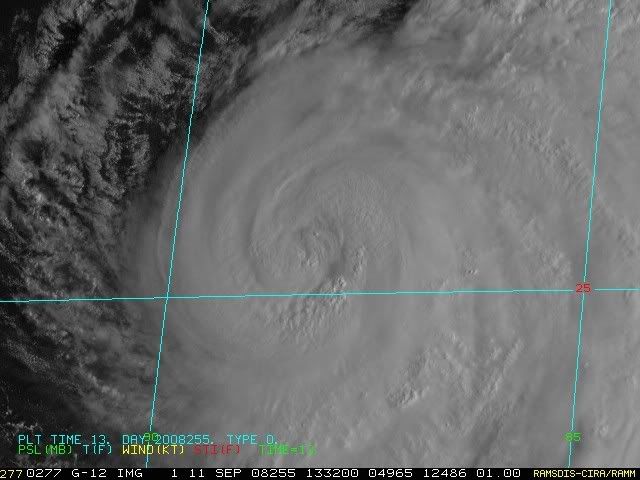
The outer eye-wall is getting better organized while the inner is collapsing!

0 likes
Re: ATL IKE: Category 2 - Discussion
Derek Ortt wrote:ConvergenceZone wrote:HouTXmetro wrote:Although not likely , could Ike suprise us and Hit Cat 4 Status?
Extremely doubtful for a cat4 now. It's just not that type of system and once the outflow gets over land it will choke it off a bit anyway...If it can't get it's act together now, I don't see how it will do it later.
this can go from a 2 to a 4 very quickly once this eyewall struff finally ceases
I keep thinking this same thing. Overall storm presentation is fantastic, its just that inner core that seems to be in flux all the time. With the sheer size of the wind field, if it began to tighten up, all that energy would have to go into something. Are there any negative factors besides questionable water temps in the gulf right now? All signs are go for intensity increase still arent they? Any doubts are coming just from the lack of response in wind increase, but everything else is there??
0 likes
-
Hurricanewatcher2007
- Category 2
- Posts: 578
- Joined: Sat Jul 05, 2008 8:10 pm
Re:
Frank2 wrote:I'm going to take a big guess and say that Ike will remain about the same up to landfall - too much dry air to the north and west of the system...
As the NHC said, Ike is a bit of a anomaly since the pressure is very low but the winds are not very high, so, so far so good...
I just wish TWC would stop repeating those "packing up and getting out" film bites every hour - hopefully it will not be necessary, for anyone other than on Galveston Island...
Frank
Like Derek just said and I have been saying all morning once this EWRC is complete which its well underway it will ramp up to cat 4 very quickly. It already has the pressure for cat 4 so once it can finally put all of its energy into one eye-wall it could explode!
0 likes
I'd also have to agree with the poster who said that since the system hasn't intensified up to now, it's likely not to as it gets closer to land, since more dry hot air is being pulled into the system...
Just looking at the west side of Ike should answer any doubts about whether any dry is air present - there is...
Just looking at the west side of Ike should answer any doubts about whether any dry is air present - there is...
0 likes

-
fox13weather
- Professional-Met

- Posts: 161
- Joined: Tue Sep 20, 2005 7:49 pm
Re: ATL IKE: Category 2 - Discussion
Geeee, everyone is entitled their opinion, but the number of posts from people here that are stating "facts" about a complex science when they have absolutely no qualifications to do so is alarming. As a pro met, I would not be wandering over to a board devoted to cancer and come up with "absolutes" on cancer treatment methods. If I had the time I would go back and correct each post, but I do not. In the meantime, it is irresponsible to do satellite, recon, and model analysis based on an earth science class some of you may have taken in the 7th grade.
0 likes

Ike starting to pay SELA a visit. Radar Link to first major outer band and marine warning south of Mobile Bay:
http://radar.weather.gov/radar.php?rid= ... 11&loop=no
Here's a photo of that squall looking SE down Poydras Ave. Unfortunately by the time I parked, the deluge had started.

Will post more shots as warranted. Get ready Texas Coast!
Steve
http://radar.weather.gov/radar.php?rid= ... 11&loop=no
Here's a photo of that squall looking SE down Poydras Ave. Unfortunately by the time I parked, the deluge had started.

Will post more shots as warranted. Get ready Texas Coast!
Steve
0 likes

Problem is its already finished one EWRC and another has started pretty much right away, the first inner eyewlal went away probably about 6-9hrs ago, the outer one has contracted steadily inwards and now is the inner eyewall...only for another outer eyewall set-up pretty much instantly.
Still IF it can get this eyewall stuff sorted out, like Derek said this could very easily ramp upto a cat-4, the pressure is there and the conditions are there, its just the inner core thats a mess...and if it sorts that out then the presentation is there for this to ramp the winds up.
Still IF it can get this eyewall stuff sorted out, like Derek said this could very easily ramp upto a cat-4, the pressure is there and the conditions are there, its just the inner core thats a mess...and if it sorts that out then the presentation is there for this to ramp the winds up.
Last edited by KWT on Thu Sep 11, 2008 8:43 am, edited 1 time in total.
0 likes

Re: ATL IKE: Category 2 - Discussion
I can report that coastal mississippi is getting quite a bit of coastal flooding. The water at beach BLVD in Pascagoula is lapping over the road. Breezy and ominous but otherwise nothing major there yet. Actually just got work water is in first parkign garage floor of hard rock casino. That is where it was with GUSTAV!...LA is going to wopped no matter what.
Last edited by PTPatrick on Thu Sep 11, 2008 8:44 am, edited 1 time in total.
0 likes
Re:
Windy wrote:I think it's interesting that people get so focused on the category numbers. A small CAT 4 storm is a very big deal for whereever it landfalls. A Cat 2 storm with Cat 2 winds 110 miles away from center and TS winds nearly a few hundred miles away is HUGE storm that spanks an ENORMOUS swath of land with wind and surge, and for a much longer time. What makes a storm a Cat 2 or a Cat 4 is only the maximum sustained winds, which usually only extend out a small distance from the center or circulation. In this storm, the max winds extend waaaaaaaay beyond what I think most people are used to. It is quite possible you could be sitting on the TX/LA border very late Friday night and getting sustained CAT 2 winds and surge... until nearly mid Saturday! I actually HOPE this tightens up into a Cat 3/4 and brings the wind field in a bit, or a lot of people are going to be surprised and in serious trouble at landfall.
This is obviously not a forecast; don't rely on me, rely on trained weather professionals, yadda yadda yadda.
Just my opinion, but if you even suspect you are going to be affected by Ike, prepare now. The first thing to go is power. If you haven't lived without electricity for a few weeks, you can't begin to imagine what it's like...I'm not saying this to scare anyone, just to make folks think about what they might need to do now. I'd wash every item of laundry I could...because you might not have the luxury of a washer or dryer for a while.
Make as much ice as possible NOW while there's still time. Make sure you have enough water, mosquito repellant and other necessities to live for at least 4 - 7 days after the storm is over. Put your important papers in plastic ziploc bags...there are tons of sites on the Internet that have detailed preperation tips and there's even a thread devoted to prep here at Storm2K. If you haven't prepared properly, take the time, read the tips and then follow the steps.
This is important! If possible, talk to your neighbors..form a group with them so you can work together after the rain and wind stop. Even if you're little more than nodding acquaintances, now is the time to introduce yourself!
There are many productive things you can do now in the hours before landfall. These are the most important hours you can spend. Do your prep work now. You'll be so glad later!
BocaGirl
Barbara
Last edited by BocaGirl on Thu Sep 11, 2008 8:44 am, edited 1 time in total.
0 likes
-
sallylou666

- Tropical Wave

- Posts: 4
- Joined: Mon Sep 08, 2008 1:54 pm
- Location: Houston, Texas
-
Nederlander
- S2K Supporter
- Posts: 1259
- Joined: Sat Jul 19, 2008 4:28 pm
- Location: Conroe, TX
Re:
Frank2 wrote:I'd also have to agree with the poster who said that since the system hasn't intensified up to now, it's likely not to as it gets closer to land, since more dry hot air is being pulled into the system...
Just looking at the west side of Ike should answer any doubts about whether any dry is air present - there is...
listen to the promets... Derek stated that this could instensify to cat 4 rather quickly once the core gets it act together
0 likes
Right, but Fox13 has a valid point. Many of us are more than casual weather watchers, but people shouldn't be claiming anything in absolutes. Far be it from me to pretend to know the science of the thing. I'm better at the art of it anyway.
Steve
Steve
Last edited by Steve on Thu Sep 11, 2008 8:45 am, edited 1 time in total.
0 likes
Who is online
Users browsing this forum: No registered users and 19 guests