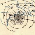
ATL: IKE Discussion

Moderator: S2k Moderators

Message
Author
fasterdisaster
Category 5
Category 5
Posts: 1868
Joined: Mon Sep 19, 2005 4:41 pm
Location: Miami, Florida

Re: ATL IKE: Category 2 - Discussion

#9921 Postby fasterdisaster » Thu Sep 11, 2008 9:29 pm

terrapintransit wrote:
fasterdisaster wrote:
peteywheatstraw wrote:Been looking at observations from Buoy 42001 in the Mid Gulf at 25.9 N 89.667W - The eye must have passed pretty close to this buoy because at 4pm CST the air pressure at the buoy was 28.34in. Peak winds at the buoy today however were only 49 knots with gusts to 62 knots. Max wave hts was 30 ft at 2pm and is now most recently down to 16ft. At 750 pm winds had subsided a little to 45/58 knots with pressure rising rapidly.

Looks like Ike's going to have to do some pretty fast intensification to get to a Cat 3 or 4.


Yeah, Ike is a 60 mph tropical storm. I don't know what the NHC is smoking with this one! I mean, forget the fact it has an eye, or that dropsondes have supported 100 mph recently, I don't know how the NHC can't see this isn't even a hurricane!


Fasterdisaster......What my friend, are YOU smoking?? Do you honestly believe this is NOT a hurricane? Pass whatever it is your smoking over to me and let me see if I get that same effect because it looks like one to me.....Image


LOL I was being sarcastic since he said the buoy registered 50 kts so it seemed to be implying he didn't think this storm was as strong as said. I was emphasizing the notion that it would be crazy to think it was 60 mph :wink: (which in his reply, he said he didn't mean that, so I believe him)
0 likes   

User avatar
artist
Category 5
Category 5
Posts: 9792
Joined: Mon Jun 06, 2005 3:26 pm
Location: West Palm

Re: ATL IKE: Category 2 - Discussion

#9922 Postby artist » Thu Sep 11, 2008 9:29 pm

Hurricanewatcher2007 wrote:Galveston is already flooding in places.

can you point me to that report? Thanks!
0 likes   

User avatar
lrak
S2K Supporter
S2K Supporter
Posts: 1770
Age: 58
Joined: Thu Jun 21, 2007 2:48 pm
Location: Corpus Christi, TX

Re: ATL IKE: Category 2 - Discussion

#9923 Postby lrak » Thu Sep 11, 2008 9:30 pm

http://www.ndbc.noaa.gov/station_page.php?station=42002

really low pressure? And the buoys up toward the SE coast of Tx are a lot higher? Is thing that huge?
0 likes   

User avatar
Hurricanewatcher2007
Category 2
Category 2
Posts: 578
Joined: Sat Jul 05, 2008 8:10 pm

Re: ATL IKE: Category 2 - Discussion

#9924 Postby Hurricanewatcher2007 » Thu Sep 11, 2008 9:31 pm

artist wrote:
Hurricanewatcher2007 wrote:Galveston is already flooding in places.

can you point me to that report? Thanks!


I can't. I bought a subscription to Hurricanetrack.com and I am watching them out scouting for places to set up their equipment and they were talking about it. They are in Galveston
0 likes   

User avatar
JenBayles
Category 5
Category 5
Posts: 3461
Age: 62
Joined: Tue Aug 26, 2003 3:27 pm
Location: Houston, TX
Contact:

Re: ATL IKE: Category 2 - Discussion

#9925 Postby JenBayles » Thu Sep 11, 2008 9:31 pm

artist wrote:
Hurricanewatcher2007 wrote:Galveston is already flooding in places.

can you point me to that report? Thanks!


I don't have time to find an official report, but around noon, the local news had film of Apfel park (east end) with water beginning to cover the road. Same thing on the far west end of Galveston. The west end goes under if you sneeze, so I'm not surprised it's already flooding.
0 likes   

User avatar
lost cause
Tropical Low
Tropical Low
Posts: 24
Age: 48
Joined: Thu Aug 24, 2006 6:24 pm
Location: Galveston

Re: Re:

#9926 Postby lost cause » Thu Sep 11, 2008 9:32 pm

fasterdisaster wrote:
lost cause wrote:
fasterdisaster wrote:I wasn't aware the seawall was only 10 feet above sea level! I just heard it was 16 feet and I thought that was that, but the sand's been pushed up so the wall is only 10 feet high. In that case, this 20 foot storm surge is going to be even worse than I thought it would be! :(


Where did you see this?


TWC, but you look to be from Galveston so if they were wrong feel free to tell me, it's just what Jim Cantore said.


When the Seawall was built in 1900, the city fathers designed it to stand 17 feet and, in order to prevent the massive flooding, raised the city behind it.

Now, 108 years later, it has suffered from some beach erosion issues and the city has had large granite blocks brought in to break up the surf in an effort to prevent further undermining of the Seawall. I seriously doubt it's only 10 feet high now because if it was, the grading behind it would reveal that; I've driven many times between Seawall Blvd and Broadway and never seen such a problem. A seven foot difference between the top of the Seawall and the grading of the city would not go unnoticed.

I don't know where Jim Cantore got his info, but I don't believe it's accurate.
0 likes   

User avatar
Pebbles
S2K Supporter
S2K Supporter
Posts: 1994
Joined: Tue Jul 08, 2003 1:42 pm
Location: New Lenox, IL (SW of Chicago)

Re: ATL IKE: Category 2 - Discussion

#9927 Postby Pebbles » Thu Sep 11, 2008 9:32 pm

Ok this is a very big looking storm, it looks for sure like a hurricane. This doesn't look like a major though. Look at all the dry air right in the storm, specially to the NW of the eye. Everyone keeps going on and on about how 'good' it looks.

I don't think it's weakening... I just think it's the same as it has been all day, except the outflow has increased to the west. But there is still a ton of air in this thing ATM. Or course tis could change, but for now it hasn't.

Image
0 likes   

User avatar
Innotech
Category 5
Category 5
Posts: 1031
Joined: Mon Aug 30, 2004 5:32 pm
Location: Lafayette, Louisiana
Contact:

Re: ATL IKE: Category 2 - Discussion

#9928 Postby Innotech » Thu Sep 11, 2008 9:32 pm

having just been through Gustav, my thought and prayers go out to those of you west of me.
My uncle is in western Houston but he didnt evacuate so I hope hes going to be ok. Hel ives several miles west of the Galleria in a very nice neighborhood. do you think he will be alright there?
0 likes   

txag2005
Tropical Storm
Tropical Storm
Posts: 229
Joined: Thu Jul 17, 2008 1:16 am
Location: Houston, TX

Re: ATL IKE: Category 2 - Discussion

#9929 Postby txag2005 » Thu Sep 11, 2008 9:33 pm

What is the realistic chance this thing is a Cat 4 or 5 at landfall? Some of these comments are hoenstly scaring me.

I'm in the NE side of town hunkered down after leaving the storm surge zone earlier today. I figured I'd ride out the storm with family. Now that I read comments about Cat 4 or 5 at landfall, I'm concered about being up here even due to the fact that they project the storm to only have dropped one level by the side it hits the NE side of town (Kingwood/Humble area).

Therefore, can anyone, especially pro-mets, give me a realistic view on the chance of this happening? A cat 4 or 5 at landfall gives me some thoughts of trying to leave town all together over night.
0 likes   

User avatar
artist
Category 5
Category 5
Posts: 9792
Joined: Mon Jun 06, 2005 3:26 pm
Location: West Palm

Re: ATL IKE: Category 2 - Discussion

#9930 Postby artist » Thu Sep 11, 2008 9:33 pm

JenBayles wrote:
artist wrote:
Hurricanewatcher2007 wrote:Galveston is already flooding in places.

can you point me to that report? Thanks!


I don't have time to find an official report, but around noon, the local news had film of Apfel park (east end) with water beginning to cover the road. Same thing on the far west end of Galveston. The west end goes under if you sneeze, so I'm not surprised it's already flooding.

thanks. I have a cousin who has a house on Galveston near the Strand.
0 likes   

fasterdisaster
Category 5
Category 5
Posts: 1868
Joined: Mon Sep 19, 2005 4:41 pm
Location: Miami, Florida

#9931 Postby fasterdisaster » Thu Sep 11, 2008 9:33 pm

Where did this complete conjecture come from on TWC that the storm had 'a good chance of moving east of Galveston so that would be good news for you'? Not saying it's not possible but frankly that's just misleading.
0 likes   

User avatar
terrapintransit
Category 1
Category 1
Posts: 275
Age: 50
Joined: Tue Sep 04, 2007 8:08 pm
Location: Williamsport, Pa

Re: ATL IKE: Category 2 - Discussion

#9932 Postby terrapintransit » Thu Sep 11, 2008 9:36 pm

Yeah, Ike is a 60 mph tropical storm. I don't know what the NHC is smoking with this one! I mean, forget the fact it has an eye, or that dropsondes have supported 100 mph recently, I don't know how the NHC can't see this isn't even a hurricane![/quote]

Fasterdisaster......What my friend, are YOU smoking?? Do you honestly believe this is NOT a hurricane? Pass whatever it is your smoking over to me and let me see if I get that same effect because it looks like one to me.....Image[/quote]

LOL I was being sarcastic since he said the buoy registered 50 kts so it seemed to be implying he didn't think this storm was as strong as said. I was emphasizing the notion that it would be crazy to think it was 60 mph :wink: (which in his reply, he said he didn't mean that, so I believe him)[/quote]

Oh...Thank God you weren't serious...I guess I tapped into this thread tonight a bit late.. :A:
0 likes   

Rod Hagen
Tropical Storm
Tropical Storm
Posts: 237
Joined: Fri Sep 23, 2005 6:22 am
Location: Lives in Melbourne, works in N Queensland

Re: Re:

#9933 Postby Rod Hagen » Thu Sep 11, 2008 9:36 pm

Weatherfreak000 wrote:Sorry? .5S? That's a very vast exaggeration.


Don't really get it...the storm wobbles NW and nobody cares...it's just a wobble...but it wobbles WbyWNW and people are freaking? Frankly if you bring up the Tropical Forecast Points in your loop...it's hardly even .1S of the forecast.

With the approaching trough setting up..I highly doubt this is going to affect official landfall from the NHC.


I don't agree, weatherfreak. Take a look at the track of the centre of the core step by step from the initial position a few hours back now with lat and long turned on and you will see that the trend has been pretty much directly along 26ºN (very, very slightly N of this perhaps). The next forecast position is around 26.7ºN. If you drop a perpendicular from the line between the forecast points to the line of best fit for the current track it is pretty close to .5º S of the forecast.

Cheers

Rod
0 likes   

User avatar
Sean in New Orleans
Category 5
Category 5
Posts: 1794
Joined: Thu Aug 28, 2003 7:26 pm
Location: New Orleans, LA 30.0N 90.0W
Contact:

Re: ATL IKE: Category 2 - Discussion

#9934 Postby Sean in New Orleans » Thu Sep 11, 2008 9:36 pm

artist wrote:
Hurricanewatcher2007 wrote:Galveston is already flooding in places.

can you point me to that report? Thanks!


I'm sure the surge is beginning in Galveston. It's flooding all over SE Louisiana in low lying areas. There are reports of 3 feet of water on streets on Almonaster Blvd. in New Orleans which is inside of the levees along the Industrial Canal. Along the Eastern parts of St. Bernard Parish and Plaquemines Parish there is heavy surge coming in from the East (4 to 6 feet storm surge this evening and it is rising). Flood gates are closed in St. Bernard Parish. This big storm has high water all over the Central and Western Gulf. It sounds about right that it is starting to arrive in Galveston.
0 likes   

peteywheatstraw
Tropical Low
Tropical Low
Posts: 24
Joined: Sun Sep 10, 2006 1:40 am

Re: ATL IKE: Category 2 - Discussion

#9935 Postby peteywheatstraw » Thu Sep 11, 2008 9:36 pm

It's pretty reasonable to believe that Galveston would get a storm surge of over 25 ft. Grand Isle Blocks, a WAVCIS BUOY just So of Grand Isle has registered 24 ft wave hts today. And that's pretty far from the center.
0 likes   

User avatar
fci
S2K Supporter
S2K Supporter
Posts: 3324
Joined: Tue Sep 14, 2004 10:29 am
Location: Lake Worth, FL

Re: ATL IKE: Category 2 - Discussion

#9936 Postby fci » Thu Sep 11, 2008 9:37 pm

LOL I was being sarcastic since he said the buoy registered 50 kts so it seemed to be implying he didn't think this storm was as strong as said. I was emphasizing the notion that it would be crazy to think it was 60 mph :wink: (which in his reply, he said he didn't mean that, so I believe him)

You picked a rather curious time to lay on some sarcasm while many people out there are very scared about what the next 36 hours will bring them.
0 likes   

User avatar
Lowpressure
S2K Supporter
S2K Supporter
Posts: 2032
Age: 58
Joined: Sun Sep 14, 2003 9:17 am
Location: Charlotte, North Carolina

Re: ATL IKE: Category 2 - Discussion

#9937 Postby Lowpressure » Thu Sep 11, 2008 9:37 pm

txag2005 wrote:What is the realistic chance this thing is a Cat 4 or 5 at landfall? Some of these comments are hoenstly scaring me.

I'm in the NE side of town hunkered down after leaving the storm surge zone earlier today. I figured I'd ride out the storm with family. Now that I read comments about Cat 4 or 5 at landfall, I'm concered about being up here even due to the fact that they project the storm to only have dropped one level by the side it hits the NE side of town (Kingwood/Humble area).

Therefore, can anyone, especially pro-mets, give me a realistic view on the chance of this happening? A cat 4 or 5 at landfall gives me some thoughts of trying to leave town all together over night.

Given the structure issues to this point, I would say 4/5 is a reach for Ike. It is possible but rather doubtful. I would think to stick to the NHC projection of a 3. Derek's estimate of 105kt at landfall seems very reasonable as well. I am not a pro. I just think the wind field is too large to constrict enough for a high 4 or 5.
0 likes   

Txdivermom
Tropical Low
Tropical Low
Posts: 47
Joined: Sun Aug 31, 2008 11:49 am

Re:

#9938 Postby Txdivermom » Thu Sep 11, 2008 9:38 pm

fasterdisaster wrote:I wasn't aware the seawall was only 10 feet above sea level! I just heard it was 16 feet and I thought that was that, but the sand's been pushed up so the wall is only 10 feet high. In that case, this 20 foot storm surge is going to be even worse than I thought it would be! :(


And I'm not sure if everyone knows, but it's not a wall like the one we saw overtopped in NO during Gustav. It's like they built up a huge part of the whole island. Everything is 10+ feet up and you can walk along a sidewalk on top of the seawall. You look down 10+ feet and see the beach and the ocean.
0 likes   

User avatar
amawea
S2K Supporter
S2K Supporter
Posts: 385
Age: 73
Joined: Mon Aug 09, 2004 3:36 pm
Location: Horseshoe Bend, Ar. but from Baytown, Tx

Re: ATL IKE: Category 2 - Discussion

#9939 Postby amawea » Thu Sep 11, 2008 9:38 pm

Dang Terrapin. You took that cork under! :ggreen:
0 likes   

User avatar
wx247
S2K Supporter
S2K Supporter
Posts: 14279
Age: 42
Joined: Wed Feb 05, 2003 10:35 pm
Location: Monett, Missouri
Contact:

#9940 Postby wx247 » Thu Sep 11, 2008 9:38 pm

Great resource for inland Houston residents:

http://www.houstonhidefromthewind.org !
0 likes   


Return to “2008”

Who is online

Users browsing this forum: No registered users and 11 guests