


The" little "wave that we were tracking recently in the Central Atlantic has grown a bit :
TROPICAL WEATHER DISCUSSION
NWS TPC/NATIONAL HURRICANE CENTER MIAMI FL
205 PM EDT WED SEP 17 2008
TROPICAL WEATHER DISCUSSION FOR NORTH AMERICA...CENTRAL
AMERICA...GULF OF MEXICO...CARIBBEAN SEA...NORTHERN SECTIONS
OF SOUTH AMERICA...AND ATLANTIC OCEAN TO THE AFRICAN COAST
FROM THE EQUATOR TO 32N. THE FOLLOWING INFORMATION IS BASED
ON SATELLITE IMAGERY...METEOROLOGICAL ANALYSIS...WEATHER
OBSERVATIONS...AND RADAR.
BASED ON 1200 UTC SURFACE ANALYSIS AND SATELLITE IMAGERY THROUGH
1715 UTC.
...TROPICAL WAVES...
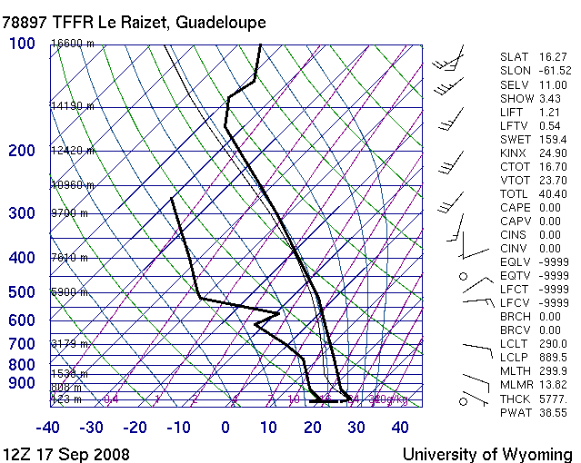
"TROPICAL WAVE IS IN THE E CARIBBEAN ALONG 64W S OF 20N MOVING W 10 KT. ISOLATED SHOWERS ARE OCCURRING IN AN AREA WITHIN 150 NM EAST OF THE WAVE AXIS NORTH OF 11N. RECENT VISIBLE SATELLITE IMAGERY INDICATES THE DEVELOPMENT OF A LOW LEVEL CIRCULATION JUST N OF THE WAVE...WHERE MODERATE CONVECTION IS FROM 22N-25N BETWEEN 62W-65W."...seems organizing just a bit this afternoon, but this has been sufficient for the Pro Met of Meteo-France based on Martinica to issue an yellow alert at 12 AM this morning.
Martinica should begin to experienced strong showers added to thunderstorms tommorow morning and this could persist throught the end of the week ( not good news) and bringing numerous floodings and maybe muslides in some areas....
Whereas no TD is anticipated by Martinica's Pro Met, and thus, with my untrained eyes
Stay tuned.
Gustywind
http://cimss.ssec.wisc.edu/tropic/real- ... g8shr.html
http://cimss.ssec.wisc.edu/tropic/real- ... g8sht.html


