

ATL: Tropical Storm Kyle : Discussion
Moderator: S2k Moderators
-
jlauderdal
- S2K Supporter

- Posts: 7240
- Joined: Wed May 19, 2004 5:46 am
- Location: NE Fort Lauderdale
- Contact:
Re: ATL INVEST 93L: Discussion
cycloneye wrote:Dr Jeff Masters morning update:
Posted by: JeffMasters, 10:20 AM EDT on September 20, 2008
Tropical disturbance 93L is slowly getting more organized. Visible satellite loops show that heavy thunderstorm activity has moved closer to the center and has increased in recent hours. However, there is no evidence of a closed surface circulation on satellite images or from last night's QuikSCAT pass. Wind shear has fallen to the moderate level, about 15 knots, and some additional slow organization of 93L appears likely today.
Wind shear is forecast to remain 10-20 knots over the next five days, and four of the six reliable forecast models now predict that 93L will develop into a tropical depression by Tuesday. This development is forecast to happen near the southeastern Bahamas. The NHC is giving 93L a medium (20%-50% chance) of developing into a tropical depression by Monday. I give a 60% chance that 93L will eventually develop into a tropical depression.
Expect heavy rains of 3-6" to affect Puerto Rico tonight through Sunday. On Sunday, heavy rain will spread to the Dominican Republic and Haiti, potentially causing life-threatening flash floods and mudslides. The southeastern Bahamas can expect rains from 93L beginning on Monday night.
im calling for a cage match between masters and wxman57, lets throw lyons in there too since he says its heading east of florida
0 likes
-
cycloneye

- Admin

- Posts: 149550
- Age: 69
- Joined: Thu Oct 10, 2002 10:54 am
- Location: San Juan, Puerto Rico
Re: ATL INVEST 93L: Discussion
If my eyes not decieve me,I can see the LLC around 15.3n-65.8w.

0 likes
-
HurricaneFreak
Re: ATL INVEST 93L: Discussion
Lyons said it will move east of the conus but what is the conus?and how far east of florida?
0 likes
-
Tropicswatcher

- Tropical Depression

- Posts: 77
- Joined: Wed Jun 01, 2005 12:53 pm
- Location: San Juan, Puerto Rico
Re: ATL INVEST 93L: Discussion
cycloneye wrote:If my eyes not decieve me,I can see the LLC around 15.3n-65.8w.
I am seeing the same! A naked swirl racing northbound..!
0 likes

TCCA21 KNHC 201412
STDECA
SATELLITE TROPICAL DISTURBANCE RAINFALL ESTIMATES
NWS TPC/NATIONAL HURRICANE CENTER MIAMI FL
1215 UTC SAT SEP 20 2008
SYSTEM NAME/IDENTIFIER...CARIBBEAN TROPICAL WAVE
MAX RAINFALL
DATE/TIME LOCATION MOTION MEAN LAST
----------- ------------ ------ ------- -------
20/1215 UTC 14.8N 65.7W 300/07 6.7 IN 8.3 IN
LAST RAINFALL DISTRIBUTION...
DISTANCE LEFT OF CENTER RIGHT OF CENTER
------------- --------------- ---------------
0 TO 1 DEGREE 0.5 TO 2.0 IN 0.5 TO 5.3 IN
1 TO 2 DEGREE 0.0 TO 0.7 IN 3.1 TO 8.3 IN
2 TO 3 DEGREE 0.0 TO 0.4 IN 0.7 TO 3.5 IN
3 TO 4 DEGREE 0.0 TO 0.1 IN 0.0 TO 0.7 IN
...LEGEND...
SYSTEM NAME/IDENTIFIER...NAME OR NUMBER ASSIGNED TO SYSTEM
(E.G. TROPICAL STORM ALPHA, TROPICAL
DISTURBANCE 01, SURFACE TROUGH)
DATE/TIME... DAY OF MONTH AND TIME IN UNIVERSAL TIME
COORDINATES (UTC) IN A DY/HRMN FORMAT
LOCATION... ESTIMATED CENTER OF SYSTEM OR ADVISORY
POSITION FOR TROPICAL CYCLONE IN TENTHS
OF DEGREES OF LATITUDE AND LONGITUDE
MOTION... ESTIMATED DIRECTION AND SPEED OF SYSTEM
IN DEGREES AND KNOTS
MEAN MAXIMUM RAINFALL... THE 24-HOUR MEAN MAXIMUM ACCUMULATION OF
RAINFALL FOR THE SYSTEM IN INCHES BASED
ON FOUR SATELLITE IMAGES SIX HOURS APART
LAST MAXIMUM RAINFALL... THE MAXIMUM ACCUMULATION OF RAINFALL FOR
THE SYSTEM IN INCHES BASED ON THE MOST
RECENT SATELLITE IMAGE
RAINFALL DISTRIBUTION... THE DISTRIBUTION OF RAINFALL WITHIN FOUR
DEGREES (240 NM) LEFT AND RIGHT OF THE
SYSTEM CENTER IN ONE DEGREE (60NM)
INCREMENTS...LOOKING DOWNSTREAM
(1 IN = 25.4 MM)
0 likes
-
Ed Mahmoud
Re: ATL INVEST 93L: Discussion
Tropicswatcher wrote:cycloneye wrote:If my eyes not decieve me,I can see the LLC around 15.3n-65.8w.
I am seeing the same! A naked swirl racing northbound..!
Still looks like a disorganized mess to me...
0 likes
-
zaqxsw75050

- Tropical Storm

- Posts: 178
- Joined: Thu Mar 06, 2008 4:21 pm
- Location: Hong Kong


-
HurricaneFreak
Re: ATL INVEST 93L: Discussion
cycloneye wrote:
were did u get this.I am trying to find it on the nhc site but i cant find it
0 likes
-
Dean4Storms
- S2K Supporter
- Posts: 6358
- Age: 63
- Joined: Sun Aug 31, 2003 1:01 pm
- Location: Miramar Bch. FL
Re: ATL INVEST 93L: Discussion
cycloneye wrote:If my eyes not decieve me,I can see the LLC around 15.3n-65.8w.
I see that swirl as well Cycloneye, appears to be moving NNW to NW at a fairly quick pace.
0 likes

Re: ATL INVEST 93L: Discussion
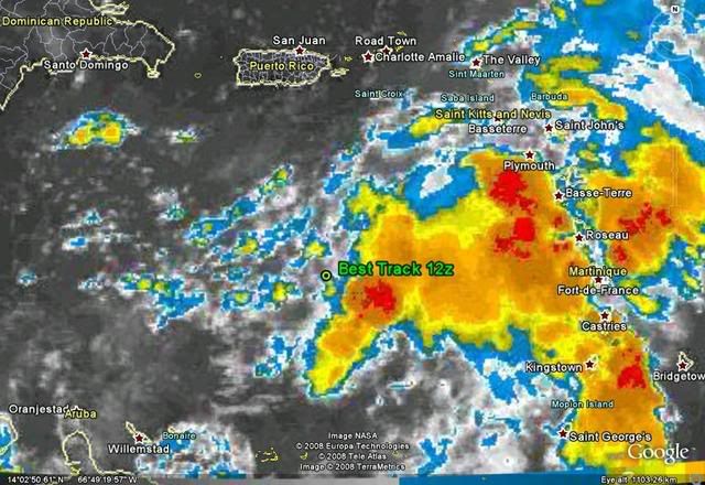
Intense squalls at this time over Basse-Terre,with gusts to 30 KTs from the south. As you can see in the floater anim,wee are now in a bulk of heavy convection,coming from the SSO; not astonih at all,cause this is the east part of the disturbance. The problem it that the ground arer saturated by 2 days now of rains.
Hope,and pray that this disturb not venture around Haiti!!!!!!!!!!!
Hope,and pray that this disturb not venture around Haiti!!!!!!!!!!!
0 likes
-
cycloneye
- Admin
- Posts: 149550
- Age: 69
- Joined: Thu Oct 10, 2002 10:54 am
- Location: San Juan, Puerto Rico
Re: ATL INVEST 93L: Discussion
Hope,and pray that this disturb not venture around Haiti!!!!!!!!!!!
Lets hope not.
0 likes
-
cycloneye
- Admin
- Posts: 149550
- Age: 69
- Joined: Thu Oct 10, 2002 10:54 am
- Location: San Juan, Puerto Rico
Re: ATL INVEST 93L: Discussion
HurricaneFreak wrote:cycloneye wrote:
were did u get this.I am trying to find it on the nhc site but i cant find it
Go to Tropical Cyclone Danger
http://www.nhc.noaa.gov/marine_forecasts.shtml
0 likes
-
Blown Away

- S2K Supporter
- Posts: 10253
- Joined: Wed May 26, 2004 6:17 am
Re: ATL INVEST 93L: Discussion
Pretty clear that is the LLC near 15.3N/65.8W moving NNW. Of course it is still disoraganized, but today 93L finally has a clear LLC, LLC is still naked but the convection is now building much closer than yesterday, and the W shear has relaxed.
http://www.ssd.noaa.gov/goes/flt/t1/loop-vis.html
http://www.ssd.noaa.gov/goes/flt/t1/loop-vis.html
0 likes


Re: ATL INVEST 93L: Discussion
No, that's just a moron in a bear outfitzaqxsw75050 wrote:
Bear watching.
0 likes
-
Cryomaniac
- Category 5

- Posts: 1289
- Joined: Tue Aug 15, 2006 2:26 pm
- Location: Newark, Nottinghamshire, UK
- Contact:
Re: ATL INVEST 93L: Discussion
zaqxsw75050 wrote:
Bear watching.
0 likes
Re: ATL INVEST 93L: Discussion
It's unbelievable how quickly the weather here has deteriorated today.  Most of the day was pretty much fair and now it's overcast and raining heavily with frequent peals of thunder that are getting louder with time.
0 likes
Who is online
Users browsing this forum: No registered users and 12 guests