ATL: Tropical Storm Kyle : Discussion
Moderator: S2k Moderators
-
bvigal

- S2K Supporter

- Posts: 2276
- Joined: Sun Jul 24, 2005 8:49 am
- Location: British Virgin Islands
- Contact:
Re: ATL: INVEST 93L - Discussion
It's quiet here right now, but we've had about 4 short-lived bouts of blowing rain since I got up at 5:30. I had the windows down to about 3/4" open and had to close them on all but W side (porch overhang there), the floor was getting wet. My unofficial rain gage is a towel on the floor under the kitchen skylight (leaks in heavy rain), and the size of the wet spot tells me we have had at least a measurable amount of rain, maybe 1/4".
0 likes
-
Ed Mahmoud
Re: ATL: INVEST 93L - Discussion
Well, after days of looking like a disorganized mess, 93L has turned a corner. Not sure if recon will find a closed surface circulation or not, but it now looks like it probably will become a tropical cyclone in the next day or so, IMHO.
0 likes


-
GeneratorPower

- S2K Supporter
- Posts: 1648
- Age: 46
- Joined: Sun Dec 18, 2005 11:48 pm
- Location: Huntsville, AL
Re: ATL INVEST 93L: Discussion
wxman57 wrote:No storms for a week! You hear that 93L? At least it looks like it's heading to the north and out to sea. Won't have to man the desk 24/7 with teams of forecasters for a fish (once it's north of Caribbean). Everyone's trying to get a rest and most of my team are still without power (some have no water) at home.
I was hunting for a better generator this afternoon. Can't find one in Houston. My current one only runs 2 hrs on a tank. Hard to sleep if I have to get up every 2 hours to fill the 1 gal tank. I can look out my window and see power 3 houses away but we may be days from getting the one stupid pole in our neighborhood replaced so that we can get power.
wxman57, check your PM about the generator.
0 likes
-
cycloneye

- Admin

- Posts: 149558
- Age: 69
- Joined: Thu Oct 10, 2002 10:54 am
- Location: San Juan, Puerto Rico
Re: ATL: INVEST 93L - Discussion
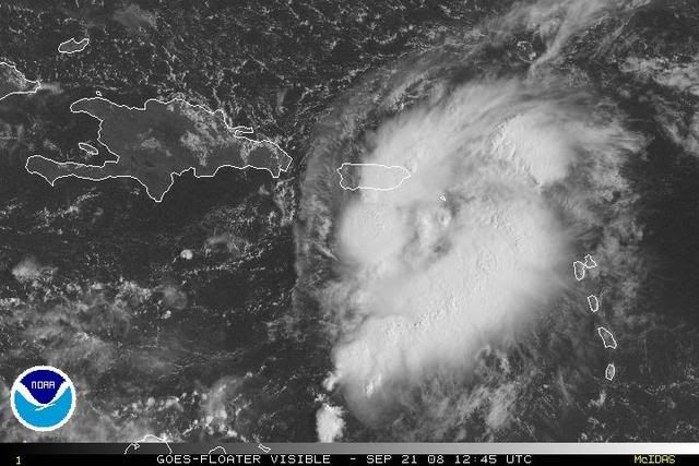
21/1145 UTC 17.6N 66.5W T1.5/1.5 93L -- Atlantic Ocean
http://www.ssd.noaa.gov/PS/TROP/positions.html
http://www.ssd.noaa.gov/PS/TROP/positions.html
0 likes


-
wxman57

- Moderator-Pro Met

- Posts: 23175
- Age: 68
- Joined: Sat Jun 21, 2003 8:06 pm
- Location: Houston, TX (southwest)
Re: ATL: INVEST 93L - Discussion
Lowpressure wrote:Radar loop above sure looks like a closed circulation to me.
Just keep in mind that radar isn't showing the surface winds. The farther away from the radar source, the higher in the clouds you're looking. Let me see if I can get GARP running on this weak wireless connection so I can make a surface plot of the NE Caribbean. That's where to look for an LLC - surface obs - not radar or satellite.
0 likes
-
Ed Mahmoud
Re: ATL: INVEST 93L - Discussion
wxman57 wrote:Lowpressure wrote:Radar loop above sure looks like a closed circulation to me.
Just keep in mind that radar isn't showing the surface winds. The farther away from the radar source, the higher in the clouds you're looking. Let me see if I can get GARP running on this weak wireless connection so I can make a surface plot of the NE Caribbean. That's where to look for an LLC - surface obs - not radar or satellite.
You don't have to work for a system that looks like it is headed to sleep with Lucca Brazzi, but turns back Northwest towards the Mid-Atlantic?
BTW, despite being in a deep blue zip code, no power until after 9/25, I've had power since very late Wednesday. There are isolated streets around the neighborhood still dark, however.
My wife's Tia Elvira and Tio Jorge have lights next block over, but a tree took down a pole with a transformer on their block, so no idea when they get back online.
The out to sea head fake and back courtesy of 0Z GFDL, BTW, and would make Joe Bastardi proud.
0 likes
-
bvigal
- S2K Supporter
- Posts: 2276
- Joined: Sun Jul 24, 2005 8:49 am
- Location: British Virgin Islands
- Contact:
Re: ATL: INVEST 93L - Discussion
Just saved a picture of radar long-range loop. Per 12z position estimate, you can look yourself at
http://radar.weather.gov/radar.php?rid= ... 11&loop=no
and hover your cursor over the area until the box lower right shows 17.0N 66.5W. Same area on looping looks to be a circulation. (Wxman, I know it's not on the surface in the radar beam, surely not arguing that fact, but it's close enough, and matches the fix position. To me, it means something to SEE it on radar, even if it's above surface.) I'm not claiming it's closed, would not go that far. We'll see what recon finds later.
0 likes
-
wxman57
- Moderator-Pro Met
- Posts: 23175
- Age: 68
- Joined: Sat Jun 21, 2003 8:06 pm
- Location: Houston, TX (southwest)
Re: ATL: INVEST 93L - Discussion
Ed Mahmoud wrote:
You don't have to work for a system that looks like it is headed to sleep with Lucca Brazzi, but turns back Northwest towards the Mid-Atlantic?
BTW, despite being in a deep blue zip code, no power until after 9/25, I've had power since very late Wednesday. There are isolated streets around the neighborhood still dark, however.
My wife's Tia Elvira and Tio Jorge have lights next block over, but a tree took down a pole with a transformer on their block, so no idea when they get back online.
The out to sea head fake and back courtesy of 0Z GFDL, BTW, and would make Joe Bastardi proud.
Sure do have to go on 24/7 coverage for this system if it develops. I think it may merge with the predicted storm center along the Mid Atlantic Coast late this week. Could be impacting our east coast clients.
Here's a GARP image. Not much evidence of an LLC and winds around the area only 5-15 kts. Certainly no TD now. Not much for recon to fly into today. Earliest possible TD is tomorrow, I'd think.

Last edited by wxman57 on Sun Sep 21, 2008 8:27 am, edited 1 time in total.
0 likes
-
Ed Mahmoud
Re: ATL: INVEST 93L - Discussion
bvigal wrote:Just saved a picture of radar long-range loop. Per 12z position estimate, you can look yourself at
http://radar.weather.gov/radar.php?rid= ... 11&loop=no
and hover your cursor over the area until the box lower right shows 17.0N 66.5W. Same area on looping looks to be a circulation. (Wxman, I know it's not on the surface in the radar beam, surely not arguing that fact, but it's close enough, and matches the fix position. To me, it means something to SEE it on radar, even if it's above surface.) I'm not claiming it's closed, would not go that far. We'll see what recon finds later.
Yeah, not sure why we argue these points too finely. If there is a big blob of convection, reasonably favorable conditions, and radar shows a circulation, even if it is mid-level, it would seem odds are better than even a surface circulation will develop within a day or two. In my humble and unproffesional opinion.
0 likes
-
wxman57
- Moderator-Pro Met
- Posts: 23175
- Age: 68
- Joined: Sat Jun 21, 2003 8:06 pm
- Location: Houston, TX (southwest)
Re: ATL: INVEST 93L - Discussion
bvigal wrote:Just saved a picture of radar long-range loop. Per 12z position estimate, you can look yourself at
http://radar.weather.gov/radar.php?rid= ... 11&loop=no
and hover your cursor over the area until the box lower right shows 17.0N 66.5W. Same area on looping looks to be a circulation. (Wxman, I know it's not on the surface in the radar beam, surely not arguing that fact, but it's close enough, and matches the fix position. To me, it means something to SEE it on radar, even if it's above surface.) I'm not claiming it's closed, would not go that far. We'll see what recon finds later.
http://img180.imageshack.us/img180/9356/93lonradarji8.jpg
There may be something there aloft, but the surface obs say any lower pressure or possible weak LLC is near the SW tip of PR now - to the WNW of any higher-level circulation. This is an indication that the system is still experiencing wind shear.
0 likes
-
cycloneye
- Admin
- Posts: 149558
- Age: 69
- Joined: Thu Oct 10, 2002 10:54 am
- Location: San Juan, Puerto Rico
Re: ATL: INVEST 93L - Discussion
For the members who dont know about the highest peak mountain in Puerto Rico,its Cerro Punta in the central part of the island at 4,389 feet as part of la Cordillera Central.La Cordillera Central is a range of mountains that goes east to west in Central Puerto Rico.Also there is another range of mountains in Eastern Puerto Rico and its name is Sierra de Luquillo,where el Yunque peak is 3,494 feet and Pico del toro is 3,524 feet.I am posting this information as the members will keep this in mind as the system crosses the island.
0 likes
-
bvigal
- S2K Supporter
- Posts: 2276
- Joined: Sun Jul 24, 2005 8:49 am
- Location: British Virgin Islands
- Contact:
Re: ATL: INVEST 93L - Discussion
wxman57 wrote:bvigal wrote:Just saved a picture of radar long-range loop. Per 12z position estimate, you can look yourself at
http://radar.weather.gov/radar.php?rid= ... 11&loop=no
and hover your cursor over the area until the box lower right shows 17.0N 66.5W. Same area on looping looks to be a circulation. (Wxman, I know it's not on the surface in the radar beam, surely not arguing that fact, but it's close enough, and matches the fix position. To me, it means something to SEE it on radar, even if it's above surface.) I'm not claiming it's closed, would not go that far. We'll see what recon finds later.
http://img180.imageshack.us/img180/9356/93lonradarji8.jpg
There may be something there aloft, but the surface obs say any lower pressure or possible weak LLC is near the SW tip of PR now - to the WNW of any higher-level circulation. This is an indication that the system is still experiencing wind shear.
Maybe I wasn't clear. Here was my point: The fix position issued by NHC at 8am matches circulation shown on radar at 8:18am. That's ALL I was saying, that's all, nothing more.
0 likes
Who is online
Users browsing this forum: No registered users and 12 guests