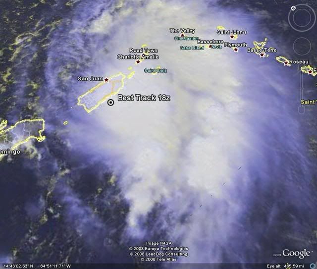
18:00 UTC Best Track.
AL, 93, 2008092118, , BEST, 0, 178N, 665W, 30, 1009, DB,
ATL: Tropical Storm Kyle : Discussion
Moderator: S2k Moderators
-
cycloneye

- Admin

- Posts: 149559
- Age: 69
- Joined: Thu Oct 10, 2002 10:54 am
- Location: San Juan, Puerto Rico
Re: ATL: INVEST 93L - Discussion
0 likes
-
cycloneye
- Admin
- Posts: 149559
- Age: 69
- Joined: Thu Oct 10, 2002 10:54 am
- Location: San Juan, Puerto Rico
Re: ATL: INVEST 93L - Discussion
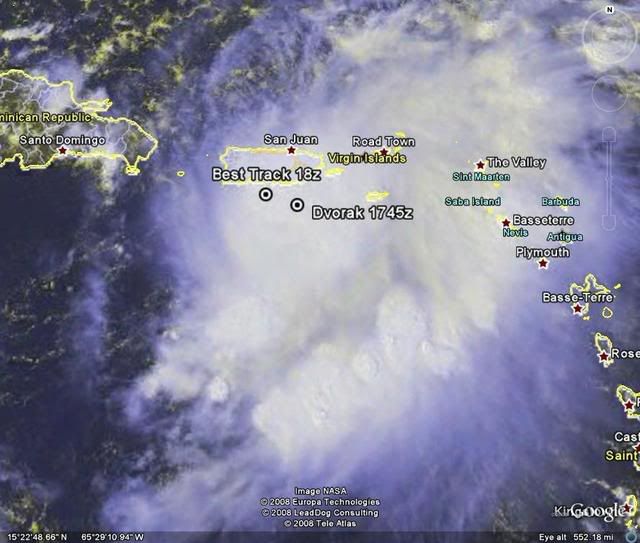
HURAKAN,put this other position in the graphic,the ssd dvorak.
21/1745 UTC 17.6N 66.0W T1.5/1.5 93L -- Atlantic Ocean
21/1745 UTC 17.6N 66.0W T1.5/1.5 93L -- Atlantic Ocean
0 likes
-
terrapintransit

- Category 1

- Posts: 275
- Age: 51
- Joined: Tue Sep 04, 2007 8:08 pm
- Location: Williamsport, Pa

-
Weatherfreak000
This storm is a Tropical Depression...Recon has been confirming winds...and even on the slim chance they don't find the LLC evidence...we're talking about only a matter of time before this does.
Let's just start advisories already i'd say...not like they dont do that sort of thing anyway ask the GOM
Let's just start advisories already i'd say...not like they dont do that sort of thing anyway ask the GOM
0 likes

Re: ATL: INVEST 93L - Discussion
Seeing that I have nothing better to do at the moment I am putting my head on the chopping block. When Recon is done we will have a 40mph TS Kyle. Satellite and radar presentation looks pretty good for this system to be classified.
0 likes
-
carolina_73

- Tropical Storm

- Posts: 148
- Joined: Wed Jul 23, 2008 1:30 am
Re: ATL: INVEST 93L - Discussion
One thing for sure is we will have a large high pressure area moving out over the Atlantic from Canada. This would block 93L and turn it back to the west. Looks like an EC threat from the Carolinas to New England at the moment.
0 likes
-
Matt-hurricanewatcher
Re: ATL: INVEST 93L - Discussion
I think it has some kind of west wind, but it is not quite closed and is over PR. Maybe close to tropical storm strength...I don't expect a upgrade at 5, that is all I'm going to say.
0 likes
-
bvigal

- S2K Supporter

- Posts: 2276
- Joined: Sun Jul 24, 2005 8:49 am
- Location: British Virgin Islands
- Contact:
Re: ATL: INVEST 93L - Discussion
Code: Select all
Mayaguez/Eugenio   18.27N  67.15W   9/21/2008 18:55   6 kt, W (260 degrees)   1011.2 mb   86.0°F   77.0°F   75%
Aguadilla/Borinq   18.50N  67.13W   9/21/2008 18:50   8 kt, ESE (110 degrees)   1011.5 mb   86.0°F   78.8°F   79%
Ponce/Mercedita   18.02N  66.57W   9/21/2008 16:50   5 kt, NE (50 degrees)   1011.9 mb   78.8°F   78.8°F   100%   Heavy Rain
San Juan/Wfo   18.43N  66.02W   9/21/2008 18:56   10 kt, E (90 degrees)   1011.9 mb   75.9°F   73.0°F   91%   Heavy Rain, Mist
St Thomas (King)   18.33N  64.98W   9/21/2008 18:53   18 kt, SE (140 degrees)   1013.2 mb   N/A   N/A   N/A   Light Rain
Christiansted   17.70N  64.80W   9/21/2008 18:53   10 kt, SE (130 degrees)   1014.2 mb   77.0°F   75.0°F   94%   Rain
0 likes
-
El Nino

- Category 1
- Posts: 454
- Age: 48
- Joined: Sun Oct 16, 2005 3:18 pm
- Location: Lima - Miraflores (Peru)
- Contact:
Re: ATL: INVEST 93L - Discussion
We needs S'ly and N'ly winds to have a LLC. It appears 93L doesn't have it for the moment.
0 likes
-
Matt-hurricanewatcher
Re: ATL: INVEST 93L - Discussion
I expect this to be upgraded around 5pm on Monday...Maybe to Kyle. It will go north of DR/Hati, but with a west-northwest to northwest track througthout the next 36-48 hours.
0 likes
-
Matt-hurricanewatcher
Re: ATL: INVEST 93L - Discussion
No LLC found by recon and recon is going home. I believe next one will be out tomarrow afternoon?
0 likes
-
MiamiensisWx
Interestingly, the latest ATCF dynamic model guidance (18Z) also exhibits the official (OFCI) TPC track. Note that the center is initialized inland over Puerto Rico (near bvigal's estimate), which is corrobated by reconnaissance data and surface observations.
http://raleighwx.easternuswx.com/models/atcf/18zatcfearlyinvest3best.gif
An OFCI wind forecast is evident on the early intensity guidance forecast graphic:
http://raleighwx.easternuswx.com/models/atcf/18zearly3.gif
http://raleighwx.easternuswx.com/models/atcf/18zatcfearlyinvest3best.gif
An OFCI wind forecast is evident on the early intensity guidance forecast graphic:
http://raleighwx.easternuswx.com/models/atcf/18zearly3.gif
Last edited by MiamiensisWx on Sun Sep 21, 2008 3:27 pm, edited 4 times in total.
0 likes
-
bvigal
- S2K Supporter
- Posts: 2276
- Joined: Sun Jul 24, 2005 8:49 am
- Location: British Virgin Islands
- Contact:
Re: ATL: INVEST 93L - Discussion
I think if there was a low, closed or not, it went ashore - makes sense in the timeframe with the fix positions, ground reports, and recon. It will have to cross PR's mountains and see what's left on the other side.

0 likes
-
wxman57

- Moderator-Pro Met

- Posts: 23175
- Age: 68
- Joined: Sat Jun 21, 2003 8:06 pm
- Location: Houston, TX (southwest)
Re:
Weatherfreak000 wrote:This storm is a Tropical Depression...Recon has been confirming winds...and even on the slim chance they don't find the LLC evidence...we're talking about only a matter of time before this does.
Let's just start advisories already i'd say...not like they dont do that sort of thing anyway ask the GOM
No TD, no TS today. Very disorganized low-level wind field. Can't just name a disorganized cluster of thunderstorms a TD. You'll have to wait until Monday.
0 likes
-
HURAKAN

- Professional-Met

- Posts: 46084
- Age: 39
- Joined: Thu May 20, 2004 4:34 pm
- Location: Key West, FL
- Contact:
715
WONT41 KNHC 212013
DSAAT
SPECIAL TROPICAL DISTURBANCE STATEMENT
NWS TPC/NATIONAL HURRICANE CENTER MIAMI FL
415 PM EDT SUN SEP 21 2008
SATELLITE IMAGERY...SURFACE OBSERVATIONS...RECONNAISSANCE AIRCRAFT
DATA...AND NOAA DOPPLER WEATHER RADAR DATA FROM SAN JUAN PUERTO
RICO INDICATE THE BROAD LOW PRESSURE AREA PREVIOUSLY OVER THE
NORTHEASTERN CARIBBEAN SEA IS NOW CENTERED OVER CENTRAL AND WESTERN
PUERTO RICO. THE AIRCRAFT REPORTED 30 TO 35 MPH SURFACE WINDS IN
SQUALLS TO THE SOUTH AND EAST OF THE CENTER. HOWEVER...THE DATA
SHOW THE SYSTEM DOES NOT YET HAVE A WELL-DEFINED SURFACE
CIRCULATION.
THE LOW IS EXPECTED TO MOVE GENERALLY NORTHWARD DURING THE NEXT DAY
OR TWO...AND COULD BECOME A TROPICAL DEPRESSION AT ANY TIME.
REGARDLESS OF DEVELOPMENT...LOCALLY HEAVY RAINFALL WILL CONTINUE
OVER PUERTO RICO AND THE U. S. AND BRITISH VIRGIN ISLANDS THROUGH
MONDAY. THESE RAINS COULD CAUSE LIFE-THREATENING FLASH FLOODS AND
MUDSLIDES. INTERESTS IN PUERTO RICO...THE U.S. AND BRITISH VIRGIN
ISLANDS...AND EASTERN HISPANIOLA SHOULD MONITOR THE PROGRESS OF
THIS SYSTEM AND ANY PRODUCTS ISSUED BY THEIR RESPECTIVE WEATHER
FORECAST OFFICES.
$$
FORECASTER BEVEN/RHOME
0 likes
-
Weatherfreak000
Re: Re:
wxman57 wrote:Weatherfreak000 wrote:This storm is a Tropical Depression...Recon has been confirming winds...and even on the slim chance they don't find the LLC evidence...we're talking about only a matter of time before this does.
Let's just start advisories already i'd say...not like they dont do that sort of thing anyway ask the GOM
No TD, no TS today. Very disorganized low-level wind field. Can't just name a disorganized cluster of thunderstorms a TD. You'll have to wait until Monday.
I know Wxman, I was being sarcastic. Just taking a stab at the classifications you would be in the GOM.
0 likes
Who is online
Users browsing this forum: No registered users and 14 guests