Subtropical Development in the NE Atlantic? New System
Moderator: S2k Moderators
Forum rules

The posts in this forum are NOT official forecasts and should not be used as such. They are just the opinion of the poster and may or may not be backed by sound meteorological data. They are NOT endorsed by any professional institution or STORM2K. For official information, please refer to products from the National Hurricane Center and National Weather Service.
-
littlevince

- S2K Supporter

- Posts: 768
- Joined: Fri Oct 21, 2005 10:45 am
- Location: Portugal
-
Weatherfreak000

Re: Subtropical Development in the NE Atlantic?
This system looks better than Jerry of last year. Seems like NHC has a habit of ignoring the NE Atlantic. There was the unnamed STS of 2005 and the one late last year that looked like an STS as well.
0 likes


-
vegastar
- Category 1

- Posts: 320
- Age: 49
- Joined: Fri Aug 03, 2007 9:13 am
- Location: Trofa, Portugal (41.33º N 8.55º W)
Re: Subtropical Development in the NE Atlantic?


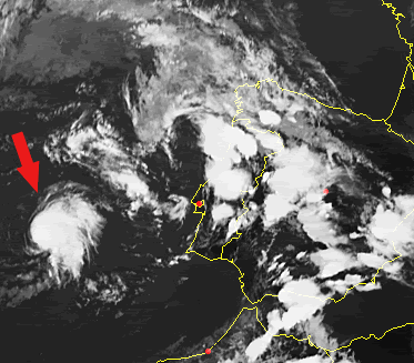
Some 30-35 kts barbs near the center on the western (sheared) side of the circulation. On the eastern side there are higher winds but they are rain contaminated.
The wind field is very large and broad but unlike extratropical cyclones the maximum winds are clearly near the center of circulation.
I think we may have a STD.
0 likes
-
vegastar
- Category 1
- Posts: 320
- Age: 49
- Joined: Fri Aug 03, 2007 9:13 am
- Location: Trofa, Portugal (41.33º N 8.55º W)
Re: Subtropical Development in the NE Atlantic?
 [/URL]
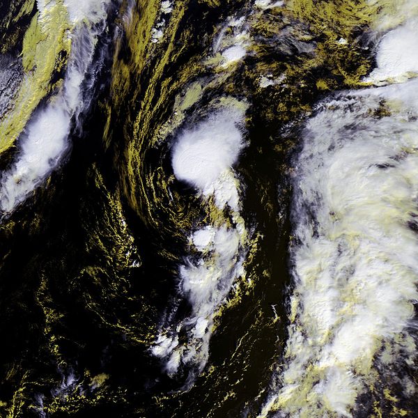
On the higher resolution quickscat there are some 40kts+ barbs on the eastern side of the COC, so I guess we could have a STS...
0 likes
-
Cainer

- Tropical Storm

- Posts: 188
- Age: 34
- Joined: Mon May 05, 2008 3:26 pm
- Location: Yarmouth, Nova Scotia
I emailed the NHC about this; I hope they answer me before it dies off! I'll let you guys know if I get an answer from them. Anyway, in my opinion, this is a STS. It's sort of strange that the NHC haven't even mentioned it yet. They at least mentioned 95L last year, and it was in this general position, later in the year, AND looking worse. Go figure.
0 likes
-
DESTRUCTION5

- Category 5

- Posts: 4430
- Age: 44
- Joined: Wed Sep 03, 2003 11:25 am
- Location: Stuart, FL
Re:
CrazyC83 wrote:I agree that this is a subtropical or tropical storm. I don't think the NHC puts too much energy in this region though. No mentions on any TWD's or TWO's. I'd initiate advisories on 40 kt STS Kyle here IMO.
Agree this should be named NOW or in the postseason for sure!
0 likes
-
CrazyC83
- Professional-Met

- Posts: 34315
- Joined: Tue Mar 07, 2006 11:57 pm
- Location: Deep South, for the first time!
Re: Subtropical Development in the NE Atlantic?
Post deleted due to large change required.
Last edited by CrazyC83 on Sun Sep 21, 2008 9:54 pm, edited 2 times in total.
0 likes
-
Just Joshing You

- Category 2

- Posts: 512
- Joined: Sat Nov 03, 2007 10:29 am
- Location: Nova Scotia

Re: Subtropical Development in the NE Atlantic?
Jeff Masters said it had a warm core. Looks better than Jerry from last year. It would not surprise me if this is really is at least a subtropical or tropical system which would be Kyle. I am surprised NHC does not pay much attention to the Eastern Atlantic because its where Europe is.
0 likes

-
HURAKAN

- Professional-Met
- Posts: 46084
- Age: 39
- Joined: Thu May 20, 2004 4:34 pm
- Location: Key West, FL
- Contact:
Portugul's storm
An extratropical low pressure system off the coast of Portugal has gradually warmed its core over the past 2-3 days, as it has wandered over waters of 22-23°C. This storm has developed some heavy thunderstorm activity near the center, and has winds of 40 mph, according to this evening's QuikSCAT pass. However, in NHC's subjective judgment, it does not yet have enough tropical characteristics to be named subtropical storm Kyle. This system should make landfall in southern Portugal Monday afternoon, bringing heavy rain and tropical storm force winds of 40 mph to the coast.
Link: http://www.wunderground.com/blog/JeffMa ... amp=200809
0 likes

Again, remember that the NWS has no high seas control east of 33°W. They have to confer with the appropriate weather service (Meteo-France) before doing anything.
MF have this as a 1007 mbar low.
MF have this as a 1007 mbar low.
Part 2 : General synopsis, Sunday 21 at 12 UTC
Thundery low 1007 33N17W, moving east and filling, expected 1011
just near cape Sao Vicente by 23/00UTC.
0 likes
Who is online
Users browsing this forum: No registered users and 136 guests