

ATL: Tropical Storm Kyle : Discussion
Moderator: S2k Moderators
-
gatorcane

- S2K Supporter

- Posts: 23708
- Age: 48
- Joined: Sun Mar 13, 2005 3:54 pm
- Location: Boca Raton, FL
Re: Re:
Weatherfreak000 wrote:As far as my post about a complete change in the forecast scenario...I was only referring to a passage through the Caribbean instead of the open Atlantic. I am quite aware that the huge trough in the atlantic is going to hook the storm right.
But assume the storm travels through the caribbean and hooks through S.Florida? I'd say that is a change. Of course this is all completely conjecture... the point i've made all season long since Gustav remains the same...you CAN deny a model consensus...in some situations...but your EYES can't be wrong. The model consensus is already wrong...the storm is inland...no model predicted that. But my eyes tell me a trough is present...and I trust my eyes.
There is currently no trough present. There is a cutoff low that is supposed to develop over Florida and the SE US that would cause the mid-level winds to shift to the W.....since most global models predict it, they can't be wrong right? But all global models had 93L a good bit north of where it is now heading North
as I explained in previous posts yesterday and before I just didn't believe the models....
I see no evidence of that yet....the main steering pattern for 93L is weak subtropical ridging to the NNE of it...steering it west slowly.
Last edited by gatorcane on Mon Sep 22, 2008 8:15 pm, edited 1 time in total.
0 likes
-
canetracker

- S2K Supporter
- Posts: 751
- Age: 63
- Joined: Wed Jul 27, 2005 8:49 pm
- Location: Suburbia New Orleans...Harahan, LA
Re: ATL: INVEST 93L: Discussion
gatorcane wrote:93L Looks like a Fay Redux if you ask me.....and yet again Haiti and DR under the gun big time as 93L drifts West
Hope not for DR and Haiti's sake:
Emergency officials in both the Dominican Republic and Haiti have issued warnings for heavy rain. Haiti is still struggling to recover from three recent hurricanes and a tropical storm that killed 425 people
http://www.local10.com/weather/17530265/detail.html?rss=mia&psp=news
0 likes
-
canetracker
- S2K Supporter
- Posts: 751
- Age: 63
- Joined: Wed Jul 27, 2005 8:49 pm
- Location: Suburbia New Orleans...Harahan, LA

-
cycloneye

- Admin

- Posts: 149568
- Age: 69
- Joined: Thu Oct 10, 2002 10:54 am
- Location: San Juan, Puerto Rico
Re: ATL: INVEST 93L: Discussion
canetracker wrote:gatorcane wrote:93L Looks like a Fay Redux if you ask me.....and yet again Haiti and DR under the gun big time as 93L drifts West
Hope not for DR and Haiti's sake:Emergency officials in both the Dominican Republic and Haiti have issued warnings for heavy rain. Haiti is still struggling to recover from three recent hurricanes and a tropical storm that killed 425 people
http://www.local10.com/weather/17530265/detail.html?rss=mia&psp=news
If all go to the top thread at the forum,you can see what has and still is occuring in Puerto Rico,and is only a wave.
0 likes
-
canetracker
- S2K Supporter
- Posts: 751
- Age: 63
- Joined: Wed Jul 27, 2005 8:49 pm
- Location: Suburbia New Orleans...Harahan, LA
Re: ATL: INVEST 93L: Discussion
cycloneye wrote:canetracker wrote:gatorcane wrote:93L Looks like a Fay Redux if you ask me.....and yet again Haiti and DR under the gun big time as 93L drifts West
Hope not for DR and Haiti's sake:Emergency officials in both the Dominican Republic and Haiti have issued warnings for heavy rain. Haiti is still struggling to recover from three recent hurricanes and a tropical storm that killed 425 people
http://www.local10.com/weather/17530265/detail.html?rss=mia&psp=news
If all go to the top thread at the forum,you can see what has and still is occuring in Puerto Rico,and is only a wave.
I have and it is very sad.
RedCross in PR
0 likes


-
terrapintransit

- Category 1

- Posts: 275
- Age: 51
- Joined: Tue Sep 04, 2007 8:08 pm
- Location: Williamsport, Pa
Re: ATL: INVEST 93L: Discussion
HURAKAN wrote:93L is looking pretty good considering it's over land.
It is looking really good, but how do you know where the center is?? Has it been identified yet?
0 likes
Re: ATL: INVEST 93L: Discussion
Now maybe if this splits southern half of wave stays in carribean. Gets to western carrribean
in 96-120 hrs upper conditions would be favorable for development.
in 96-120 hrs upper conditions would be favorable for development.
0 likes
-
catastrophic

- Tropical Low

- Posts: 35
- Joined: Wed Jul 23, 2008 1:50 pm
- Location: palm bay FL
this rainbow loop makes it look like its trying to form a new center in the convection south of the mona passage, but it may just be an eddie or somthing else in the upper atmosphere theres no suface data to back it up.
http://www.ssd.noaa.gov/goes/flt/t1/loop-rb.html
http://www.ssd.noaa.gov/goes/flt/t1/loop-rb.html
0 likes
-
cycloneye
- Admin
- Posts: 149568
- Age: 69
- Joined: Thu Oct 10, 2002 10:54 am
- Location: San Juan, Puerto Rico
Re: ATL: INVEST 93L: Discussion
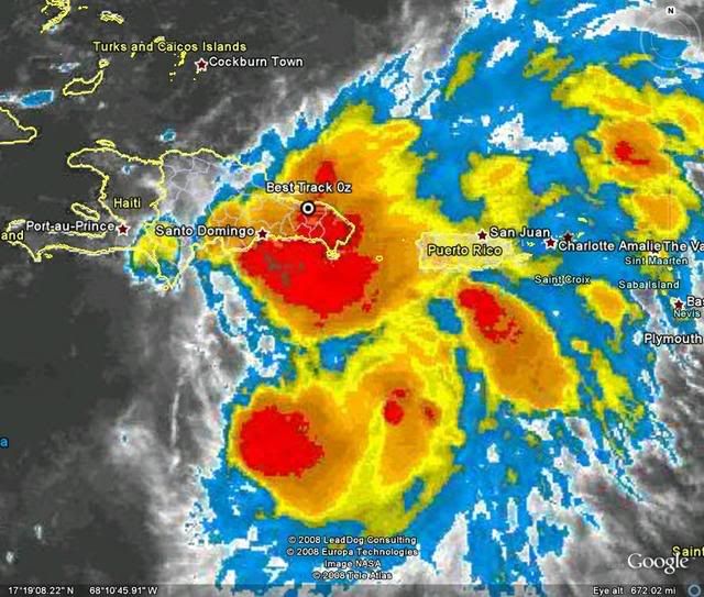
Another big batch of rain enters Puerto Rico that doesnt need anymore.

0 likes
-
lrak

- S2K Supporter
- Posts: 1770
- Age: 59
- Joined: Thu Jun 21, 2007 2:48 pm
- Location: Corpus Christi, TX
Re: ATL: INVEST 93L: Discussion
Wind is really bad in a storm, but the rain is bad bad bad. My kids are young so sue me. 
0 likes
-
HurricaneFreak
Re: ATL: INVEST 93L: Discussion
Hey I am on gatorcane's side too.This trough hasnt come in strong yet and yet this storm is still moving wnw and the more it does the more the models are wrong and then they could put the models into the Bahamas at least.But when this intensifies the models could change a lot right?Things could change fast if the trough comes in late or if it doesn't come in strong enough.Lots of senarios that the whole east coast has to watch...maybe even Florida.TWC stpehanie abrams showed possible scenarois of this that it could go out to sea,into NC then MA or west to like the Bahamas
Last edited by HurricaneFreak on Mon Sep 22, 2008 8:55 pm, edited 1 time in total.
0 likes
Re: ATL: INVEST 93L: Discussion
The only way this makes it to florida guys is as a low level cloud swirl.
0 likes
-
Matt-hurricanewatcher
Re: ATL: INVEST 93L: Discussion
This thing is slowly getting more and more westward...Because of DR/Hati this should not develop for at least another 24 hours. So yet another system for them....That is the way it is.
0 likes
-
gatorcane
- S2K Supporter
- Posts: 23708
- Age: 48
- Joined: Sun Mar 13, 2005 3:54 pm
- Location: Boca Raton, FL
Re: ATL: INVEST 93L: Discussion
HurricaneFreak wrote:Hey I am on gatorcane's side too.This trough hasnt come in strong yet and yet this storm is still moving wnw and the more it does the more the models are wrong and then they could put the models into the Bahamas at least.But when this intensifies the models could change a lot right?Things could change fast if the trough comes in late or if it doesn't come in strong enough.Lots of senarios that the whole east coast has to watch...maybe even Florida.
well I never said Florida at all...my point is that it wasn't going north so quickly and would be more west than the models suggested...and that the CONUS may need to watch this system in the long-run.
0 likes
-
hurricanefloyd5

- Category 5

- Posts: 1659
- Age: 45
- Joined: Sun May 02, 2004 10:53 am
- Location: Spartanburg
- Contact:
Re: ATL: INVEST 93L: Discussion
is this system trying to do an IKE model wise I mean this thing could very well be moving farther west of the models right???????
0 likes
-
HurricaneFreak
Re: ATL: INVEST 93L: Discussion
WELL so far one computer model points it close to Bahamas and Florida and that is CLIP.BUT Ii it to early to say that it could hit THE FAMOUS CITY OF AMERICA NYC cause a few models project it to go directly over it.


0 likes
Who is online
Users browsing this forum: No registered users and 31 guests