
Personally, I think the NHC will continue to back off from the "anytime" prediction mentioned in Sunday's TWO - as Hawkeye (MASH) would say, "How many minutes are there in an "anytime", Frank?"
The only real issue with 93L is the flooding potential - that's what this hurricane season will probably be remembered for, more than anything...
ATL: Tropical Storm Kyle : Discussion
Moderator: S2k Moderators
-
vbhoutex

- Storm2k Executive

- Posts: 29149
- Age: 74
- Joined: Wed Oct 09, 2002 11:31 pm
- Location: Cypress, TX
- Contact:
Re: ATL INVEST 93L: Discussion
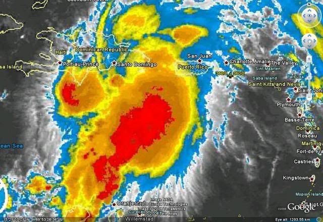
Currently still seeing a weak LLC on the N coast of DR moving little, but probably still WNW. Secondly there is definitely a secondary CC as mentioned above off the S coast also. It appears to be at the mid levels, but it is definitely there. Talk about misaligned!!!! It wouldn't be a huge surprise if 1) Recon does not find a closed LLC strong enough for classification as a TD or TS and 2)if the midlevel cc possibly becomes dominate. Like someone else said Hispaniola does weird things to TC's.
0 likes

Re: ATL INVEST 93L: Discussion
If 93L develops and heads North, what is the time frame? I am scheduled to participate in an outdoor art festival on the boardwalk in Virginia Beach this weekend, even an offshore storm would not be pleasant in a tent on the beach!
0 likes
-
Blown Away

- S2K Supporter

- Posts: 10253
- Joined: Wed May 26, 2004 6:17 am
Re: ATL INVEST 93L: Discussion

http://www.ssd.noaa.gov/goes/flt/t1/loop-vis.html
Watching the loops all morning there has been a persistent rotation near 17.8N/69.7W and the deep convection near the estimated circulation on the N coast of Hispanola has been dying off. IMO, if 93L ever becomes a TD it will happen along the S coast. I'll be surprised if recon finds a closed circulation on the N coast.
0 likes
-
HURAKAN

- Professional-Met

- Posts: 46084
- Age: 39
- Joined: Thu May 20, 2004 4:34 pm
- Location: Key West, FL
- Contact:
vbhoutex, I agree. A very pronounced MLC south of the DR. That was what I was looking in the radar a few hours ago. Jeff Masters says in his blog that a relocation of the center to the south of the DR shouldn't be expected, but I think that if the convection continues to fire around the MLC, then a relocation is certainly very possible.
Masters: "The heavy thunderstorm activity is mostly to the south and east, but there are no signs that the center of 93L will relocate itself under the heavy thunderstorm activity, and I do not expect this to happen. The thunderstorm activity is displaced to the southeast because strong upper-level winds from the west are pushing the thunderstorms away from the west side of the storm. The wind shear remains about 15 knots, which is marginal for tropical storm development."
Link: http://www.wunderground.com/blog/JeffMa ... amp=200809
0 likes

-
HURAKAN
- Professional-Met
- Posts: 46084
- Age: 39
- Joined: Thu May 20, 2004 4:34 pm
- Location: Key West, FL
- Contact:
817
ABNT20 KNHC 231748
TWOAT
TROPICAL WEATHER OUTLOOK
NWS TPC/NATIONAL HURRICANE CENTER MIAMI FL
200 PM EDT TUE SEP 23 2008
FOR THE NORTH ATLANTIC...CARIBBEAN SEA AND THE GULF OF MEXICO...
SATELLITE PICTURES INDICATE THAT THERE HAS BEEN LITTLE CHANGE WITH
THE BROAD AREA OF LOW PRESSURE CENTERED NEAR THE EASTERN DOMINICAN
REPUBLIC DURING THE PAST SEVERAL HOURS. HOWEVER...SURFACE PRESSURES
ARE FALLING IN THE AREA...AND UPPER-LEVEL WINDS ARE MARGINALLY
CONDUCIVE FOR ADDITIONAL DEVELOPMENT. THIS SYSTEM HAS THE POTENTIAL
TO BECOME A TROPICAL DEPRESSION AT ANY TIME DURING THE NEXT DAY OR
TWO AS IT MOVES SLOWLY TO THE NORTH OR NORTHWEST AWAY FROM
HISPANIOLA. HEAVY RAINFALL WITH POTENTIALLY LIFE-THREATENING FLASH
FLOODING IS EXPECTED TO CONTINUE OVER THE AREA THROUGH TOMORROW.
INTERESTS IN PUERTO RICO...THE VIRGIN ISLANDS...HISPANIOLA...THE
TURKS AND CAICOS ISLANDS...AND THE SOUTHEASTERN BAHAMAS SHOULD
CONTINUE TO MONITOR THE PROGRESS OF THIS SYSTEM AND PRODUCTS ISSUED
BY THEIR LOCAL WEATHER FORECAST OFFICES. AN AIR FORCE RESERVE
RECONNAISSANCE PLANE IS CURRENTLY INVESTIGATING THE SYSTEM.
ELSEWHERE...TROPICAL CYCLONE FORMATION IS NOT EXPECTED DURING THE
NEXT 48 HOURS.
$$
FORECASTER BLAKE
0 likes
-
Blown Away
- S2K Supporter
- Posts: 10253
- Joined: Wed May 26, 2004 6:17 am
Re: ATL INVEST 93L: Discussion
IMO, if the center relocates further S the outcome will likely be the same with the system moving generally N.
0 likes

-
Evil Jeremy

- S2K Supporter
- Posts: 5463
- Age: 32
- Joined: Mon Apr 10, 2006 2:10 pm
- Location: Los Angeles, CA
Re: ATL INVEST 93L: Discussion
Still code red at 2 PM, but the circle of concern on the GTWO has really shifted south, with most of the circle in the Caribbean. Could the NHC also be thinking that formation could be further south?
0 likes
-
HURAKAN
- Professional-Met
- Posts: 46084
- Age: 39
- Joined: Thu May 20, 2004 4:34 pm
- Location: Key West, FL
- Contact:
TROPICAL WEATHER DISCUSSION
NWS TPC/NATIONAL HURRICANE CENTER MIAMI FL
205 PM EDT TUE SEP 23 2008
...SPECIAL FEATURES...
A 1008 MB LOW PRESSURE CENTER HAS BEEN ANALYZED NEAR 19N69.5W ON
THE 12Z MAP...OR NEAR THE N COAST OF THE DOMINICAN REPUBLIC. THE
CIRCULATION AROUND THIS LOW REMAINS BROAD...WITH NUMEROUS
SHOWERS AND THUNDERSTORMS IMPACTING AREAS AROUND PUERTO RICO...
THE DOMINICAN REPUBLIC...AND ADJACENT WATERS. A LARGE CLUSTER OF
MODERATE WITH EMBEDDED STRONG CONVECTION IS FROM 12N-20N BETWEEN
66W-72W...AFFECTING A LARGE PORTION OF THE E CARIBBEAN. THE
PORTION OF THAT CONVECTION S OF 16N COULD BE ENHANCED BY
A TROPICAL WAVE ALONG 70W S OF 16N. HEAVY RAINFALL WITH
POTENTIALLY LIFE-THREATENING FLASH FLOODING AND MUDSLIDES IS
EXPECTED TO CONTINUE IMPACTING THE AREA FROM PUERTO RICO THROUGH
HISPANIOLA THROUGH EARLY WEDNESDAY. IN FACT...1.73 INCHES OF
RAIN HAVE FALLEN AT SAN JUAN PUERTO RICO OVER THE 24-HOUR PERIOD
ENDING AT 800 AM EDT TODAY. SURFACE PRESSURES ARE FALLING IN THE
VICINITY OF THE SURFACE LOW...AND UPPER-LEVEL WINDS ARE EXPECTED
TO BECOME A LITTLE MORE CONDUCIVE FOR DEVELOPMENT INTO THE NEXT
COUPLE DAYS. THIS SYSTEM HAS THE POTENTIAL TO BECOME A TROPICAL
DEPRESSION AT ANY TIME DURING THE NEXT DAY OR TWO AS IT MOVES
N/NW AWAY FROM HISPANIOLA.
"Anytime" is becoming something in the lines of "we don't know when."
0 likes
-
gatorcane

- S2K Supporter
- Posts: 23708
- Age: 48
- Joined: Sun Mar 13, 2005 3:54 pm
- Location: Boca Raton, FL
Re: ATL INVEST 93L: Discussion
how many times are we going to see this statement in the TWO when it is not happening...we've seen this statement for the past 2 days or so:
AS IT MOVES SLOWLY TO THE NORTH OR NORTHWEST AWAY FROM
HISPANIOLA
AS IT MOVES SLOWLY TO THE NORTH OR NORTHWEST AWAY FROM
HISPANIOLA
0 likes
-
gatorcane
- S2K Supporter
- Posts: 23708
- Age: 48
- Joined: Sun Mar 13, 2005 3:54 pm
- Location: Boca Raton, FL
Re: ATL INVEST 93L: Discussion
Blown_away wrote:IMO, if the center relocates further S the outcome will likely be the same with the system moving generally N.
The track reasoning would change pretty significantly in my opinion. That cutoff low would not likely steer it North in this case.
It would probably hang around south of Hispaniola for a few days.
0 likes
-
Ed Mahmoud
Re: ATL INVEST 93L: Discussion
Not sure it is exactly at the surface yet, but I'd bet small amounts of money on center relocation ballpark 18.5ºN 69.2ºW.
I hope this gets past the DR quickly...
I hope this gets past the DR quickly...
0 likes
-
HURAKAN
- Professional-Met
- Posts: 46084
- Age: 39
- Joined: Thu May 20, 2004 4:34 pm
- Location: Key West, FL
- Contact:
Loop: http://hadar.cira.colostate.edu/ramsdis ... ive_0.html
The look above clearly shows a stationary system. Models see a moving system and that's wrong. Until a clear LLC develops and starts moving, the computer models are going to be useless. Like many times this season, this system has gone further west and south than previously predicted.
The look above clearly shows a stationary system. Models see a moving system and that's wrong. Until a clear LLC develops and starts moving, the computer models are going to be useless. Like many times this season, this system has gone further west and south than previously predicted.
0 likes
-
gatorcane
- S2K Supporter
- Posts: 23708
- Age: 48
- Joined: Sun Mar 13, 2005 3:54 pm
- Location: Boca Raton, FL
Re:
HURAKAN wrote:Loop: http://hadar.cira.colostate.edu/ramsdis ... ive_0.html
The look above clearly shows a stationary system. Models see a moving system and that's wrong. Until a clear LLC develops and starts moving, the computer models are going to be useless. Like many times this season, this system has gone further west and south than previously predicted.
The models 48 hours ago had a developing system moving NNW or N about 100 miles north of the islands...
no way is this verifying at the moment. No doubt 93L is stuck with the southern wave axis developing the deepest convection.
0 likes
-
gatorcane
- S2K Supporter
- Posts: 23708
- Age: 48
- Joined: Sun Mar 13, 2005 3:54 pm
- Location: Boca Raton, FL
It's definitely starting to wrap up now...at 18N, south of DR. I think a depression may be imminent later today.
http://metofis.rsmas.miami.edu/~dortt/s ... 1_loop.gif
http://metofis.rsmas.miami.edu/~dortt/s ... 1_loop.gif
Last edited by gatorcane on Tue Sep 23, 2008 1:35 pm, edited 3 times in total.
0 likes
-
Matt-hurricanewatcher
Re: ATL INVEST 93L: Discussion
Core of the mid level centered at 18.2/69.4. This area also has developing convection that you would expect to form only over the core of a cyclone. Surface data to the east and northeast is starting to support a formation of a "LLC" there. But a ob to the northwest still shows that the LLC is to the northwest of there over land, with the center of surface obs pointing more 18.5/69.4 at this time.
Also there is a nice spin off LLC near 20.2/69.9. But not likely the main LLC.
I think that the area off the southeast coast near 18.2/69.4 will take over in the next few hours.
Also there is a nice spin off LLC near 20.2/69.9. But not likely the main LLC.
I think that the area off the southeast coast near 18.2/69.4 will take over in the next few hours.
0 likes
-
HURAKAN
- Professional-Met
- Posts: 46084
- Age: 39
- Joined: Thu May 20, 2004 4:34 pm
- Location: Key West, FL
- Contact:
Re:
gatorcane wrote:It's definitely starting to wrap up now...at 18N, south of DR. I think a depression may be imminent later today.
http://metofis.rsmas.miami.edu/~dortt/s ... 1_loop.gif
I agree. This area is becoming the more and more dominant feature by the hour.
0 likes
Who is online
Users browsing this forum: No registered users and 82 guests