Subtropical Development in the NE Atlantic? New System

This is the general tropical discussion area. Anyone can take their shot at predicting a storms path.

Moderator: S2k Moderators

Forum rules

The posts in this forum are NOT official forecasts and should not be used as such. They are just the opinion of the poster and may or may not be backed by sound meteorological data. They are NOT endorsed by any professional institution or STORM2K. For official information, please refer to products from the National Hurricane Center and National Weather Service.

Help Support Storm2K
Message
Author
CrazyC83
Professional-Met
Professional-Met
Posts: 34002
Joined: Tue Mar 07, 2006 11:57 pm
Location: Deep South, for the first time!

Re:

#61 Postby CrazyC83 » Sun Sep 21, 2008 9:34 pm

Chacor wrote:Again, remember that the NWS has no high seas control east of 33°W. They have to confer with the appropriate weather service (Meteo-France) before doing anything.
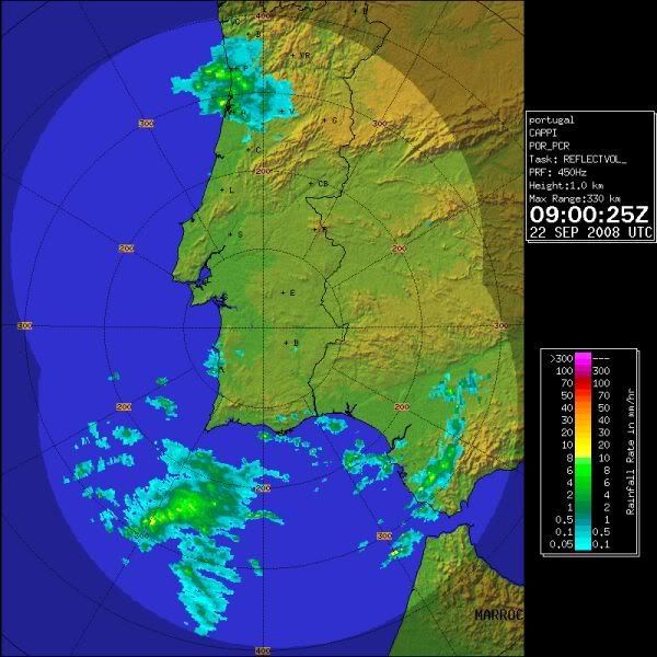
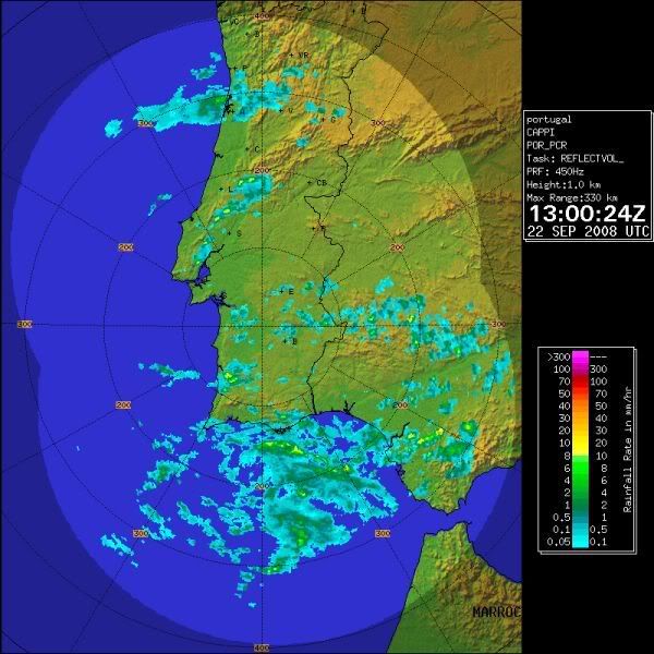
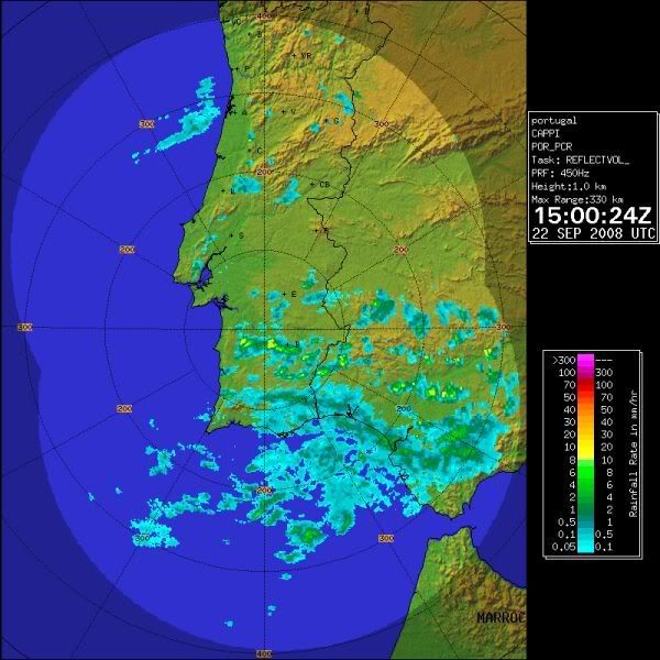
MF have this as a 1007 mbar low.

Part 2 : General synopsis, Sunday 21 at 12 UTC

Thundery low 1007 33N17W, moving east and filling, expected 1011
just near cape Sao Vicente by 23/00UTC.


What does that mean? Meteo-France has first control over the region?
0 likes   

User avatar
Chacor
Category 5
Category 5
Posts: 10229
Joined: Mon Oct 02, 2006 10:43 pm
Location: Singapore

#62 Postby Chacor » Sun Sep 21, 2008 9:40 pm

What it means is that east of 35°W (not 33°W as I earlier said) Meteo-France is tasked by WMO under the GMDSS to issue NAVTEX and high seas warnings for METAREA II.
0 likes   

User avatar
Chacor
Category 5
Category 5
Posts: 10229
Joined: Mon Oct 02, 2006 10:43 pm
Location: Singapore

#63 Postby Chacor » Sun Sep 21, 2008 10:11 pm

You should NOT be using the NHC headers. You have no right to do so.
0 likes   

Matt-hurricanewatcher

Re:

#64 Postby Matt-hurricanewatcher » Mon Sep 22, 2008 1:36 am

HURAKAN wrote:littlevince, I don't understand why the NHC is not paying any attention to this system. That's clearly a subtropical or tropical system. Extratropical systems are not like that.


I feel this is a tropical storm...This thing is blowing up a cdo over a LLC. I don't care where it is at, that is a storm. We will see if it is upgraded after the seasons over.
0 likes   

User avatar
HURAKAN
Professional-Met
Professional-Met
Posts: 46086
Age: 38
Joined: Thu May 20, 2004 4:34 pm
Location: Key West, FL
Contact:

#65 Postby HURAKAN » Mon Sep 22, 2008 4:57 am

0 likes   

User avatar
HURAKAN
Professional-Met
Professional-Met
Posts: 46086
Age: 38
Joined: Thu May 20, 2004 4:34 pm
Location: Key West, FL
Contact:

#66 Postby HURAKAN » Mon Sep 22, 2008 5:10 am

Yesterday:

Image

Now:

Image
0 likes   

User avatar
Chacor
Category 5
Category 5
Posts: 10229
Joined: Mon Oct 02, 2006 10:43 pm
Location: Singapore

#67 Postby Chacor » Mon Sep 22, 2008 7:10 am

Clearly exposed now with almost no deep convection near the centre. Latest bulletin (0900z) from M-F notes a 1009 hPa low "moving east and filling".
0 likes   

User avatar
HURAKAN
Professional-Met
Professional-Met
Posts: 46086
Age: 38
Joined: Thu May 20, 2004 4:34 pm
Location: Key West, FL
Contact:

#68 Postby HURAKAN » Mon Sep 22, 2008 8:45 am

Image
0 likes   

User avatar
HURAKAN
Professional-Met
Professional-Met
Posts: 46086
Age: 38
Joined: Thu May 20, 2004 4:34 pm
Location: Key West, FL
Contact:

#69 Postby HURAKAN » Mon Sep 22, 2008 10:36 am

Image

Continues to rain over the southern part of the Iberian Peninsula.
0 likes   

User avatar
HURAKAN
Professional-Met
Professional-Met
Posts: 46086
Age: 38
Joined: Thu May 20, 2004 4:34 pm
Location: Key West, FL
Contact:

#70 Postby HURAKAN » Tue Sep 23, 2008 5:39 am

Image

A new system develops and I will keep an eye on it!
0 likes   

User avatar
HURAKAN
Professional-Met
Professional-Met
Posts: 46086
Age: 38
Joined: Thu May 20, 2004 4:34 pm
Location: Key West, FL
Contact:

#71 Postby HURAKAN » Tue Sep 23, 2008 1:33 pm

Image

A system to watch.
0 likes   

User avatar
HURAKAN
Professional-Met
Professional-Met
Posts: 46086
Age: 38
Joined: Thu May 20, 2004 4:34 pm
Location: Key West, FL
Contact:

#72 Postby HURAKAN » Tue Sep 23, 2008 1:35 pm

Image

12z: Stationary!
0 likes   

Ed Mahmoud

Re: Subtropical Development in the NE Atlantic? New System

#73 Postby Ed Mahmoud » Tue Sep 23, 2008 1:42 pm

Image

12Z GFS seems to lose the current system South of the Azores and develops a new intense low. The original lows remnants do look as if drawn in. Looks like it starts off as an occlusion, but becomes symmetric with time.

Image

Link
0 likes   


Return to “Talkin' Tropics”

Who is online

Users browsing this forum: Google Adsense [Bot] and 34 guests