

MARINE WEATHER DISCUSSION
NWS TPC/NATIONAL HURRICANE CENTER MIAMI FL
230 PM EDT TUE SEP 23 2008
MARINE WEATHER DISCUSSION FOR GULF OF MEXICO...
CARIBBEAN SEA AND SOUTHWEST NORTH ATLC S OF 31N W OF 55W.
...SIGNIFICANT MARINE WEATHER EVENT WITH GALE WARNINGS FOR
SW N ATLC...
CARIBBEAN AND SW N ATLC...
CHANGES BEGINNING TO EVOLVE OVER THE SW N ATLC ZONE AS A
RESULT OF A TROPICAL DISTURBANCE ALONG THE NE COAST OF THE
DOMINICAN REPUBLIC AND AN EXPANSIVE AREA OF HIGH PRESSURE
CURRENTLY BUILDING OVER THE MID ATLC AND NEW ENGLAND. THE
TROPICAL DISTURBANCE APPEARS MORE ORGANIZED THAN YESTERDAY AND
RECONNAISSANCE AIRCRAFT ARE ONCE AGAIN INVESTIGATING THE SYSTEM
TO SEE IF A TROPICAL DEPRESSION HAS FORMED. DEPENDING ON THE
FINDINGS OF THE AIRCRAFT...TROPICAL CYCLONE WARNINGS MAY HAVE
TO BE ISSUED IN AN AMENDED PRODUCT.
MODELS REMAIN SPLIT IN TWO CAMPS REGARDING THE EVOLUTION OF THE
TROPICAL SYSTEM RELATIVE TO A DEVELOPING GALE/STORM CENTER OFF
THE SE COAST. THE GFS/CMC/NOGAPS/NAM AND GFS DEPICT A STRONGER
SYSTEM AND TRACK IT NWD ALONG 70W-72W TO ALONG 31N BY FRI. THE
GFS IS SOMEWHAT FURTHER E WITH THE TRACK OF THE SYSTEM. THE SAME
MODELS KEEP THE TROPICAL SYSTEM SEPARATE FROM A DEVELOPING
BAROCLINIC GALE/STORM SYSTEM OFF THE SE COAST. THE UKMET AND THE
00Z ECMWF DEPICT A WEAKER TROPICAL SYSTEM MOVING TO THE NORTH
AND THEREFORE ATTACH MORE ENERGY TO THE BAROCLINIC SYSTEM OFF
THE SE COAST.
PER THE MEDIUM RANGE CONFERENCE CALL BETWEEN TPC/HPC WILL STILL
LEAN TOWARD THE FIRST GROUP OF MODELS...ESP THE GFS AND FCST THE
TROPICAL SYSTEM TO MOVE SLOWLY NWD ALONG 70W TO NEAR 31N70W BY
FRI WHILE THE BAROCLINIC LOW DEVELOPS N OF THE AREA LATE TONIGHT
AND DRIFTS WWD TO NEAR THE NC/SC BORDER BY LATE THU/EARLY FRI.
STRONG N TO NE WINDS OF 20-30 KT ARE NOW OCCURRING JUST N OF THE
AREA AND WILL INCREASE FURTHER N OF 29N W OF THE FRONTAL TROUGH
WED AND WED NIGHT. THEREFORE WILL HOIST A GALE WARNING FOR THAT
AREA. WINDS TURN MORE NW AND SUBSIDE THU AS THE LOW MOVES TOWARD
THE SC/NC COAST. LARGE FETCH OF N TO NE WINDS ALSO PRODUCES SEAS
UP TO 16-18 FT ALONG THE AREA N OF 30N PER NWW3 AND FNMOC WAVE
MODEL. THE UKMET WAVE MODEL STILL FCST SEAS TO 20-22 FT ALONG
31N. WILL LEAN TWD THE NWW3/FNMOC WAVE MODELS.
WINDS ASSOCIATED WITH THE BAROCLINIC SYSTEM REMAIN SEPARATE
FROM ANOTHER AREA OF MODERATE TO STRONG WINDS ASSOCIATED WITH
THE NWD MOVING TROPICAL SYSTEM MAINLY OVER AREAS E OF 70W/E
SEMICIRCLE OF THE LOW.
TROPICAL N ATLC...
0944 UTC QSCAT PASS INDICATED ELY WINDS OF 20 KT OVER THE NRN
PORTION OF THE AREA ASSOCIATED WITH THE COMBINATION OF THE
PERIPHERAL CIRCULATION OF THE LOW OVER THE DOMINICAN REPUBLIC
AND A TRAILING TROPICAL WAVE ALONG 58W. MODERATE E TO SE WINDS
OF 15-20 KT SHOULD CONTINUE TONIGHT/EARLY WED AS THE TROPICAL
SYSTEM MOVES NWWD AWAY FROM THE AREA. LIGHT E TO SE WINDS
PREVAIL LATE WED THROUGH THU. WINDS BECOME NE TO E BUT REMAIN
LIGHT FRI AND INCREASE TO 15 TO 20 KT SAT AND SUN OVER N
PORTIONS IN ADVANCE OF ANOTHER TROPICAL WAVE. SEAS BUILD 6 TO 9
FT AS WELL.
GULF OF MEXICO...
SFC TROUGH ALONG 96W S OF 25N IS FCST TO DRIFT W AND SLOWLY
WEAKEN WITH LIGHT NE TO E WINDS OVER THE REMAINDER OF THE GULF
W OF 90W. NE WINDS OF 15-20 KT HAVE DEVELOPED OVER THE NE GULF
IN THE WAKE OF BUILDING HIGH PRESSURE OVER THE MID ATLC. THESE
WINDS MAY INCREASE TO 25 KT LOCALLY AND SPREAD OVER MOST OF THE
GULF N OF 25N WED. AREA OF WINDS FILTERS SWD OVER THE GULF W OF
90W THU AND FRI AS THE WINDS SUBSIDE ELSEWHERE. LIGHT WINDS
PREVAIL OVER THE GULF SAT AND SUN WITH THE EXCEPTION OF RESIDUAL
NELY WINDS OF 20-25 KT OVER THE BAY OF CAMPECHE BOTH DAYS.
WARNINGS...
ATLANTIC...
GALE WARNING...N OF 29N W OF FRONTAL TROUGH WED.
CARIBBEAN...
NONE.
GULF OF MEXICO...
NONE.
FORECASTER COBB. TROPICAL PREDICTION CENTER.
ATL: Tropical Storm Kyle : Discussion
Moderator: S2k Moderators
-
Blown Away

- S2K Supporter

- Posts: 10253
- Joined: Wed May 26, 2004 6:17 am
Re: Re:
HURAKAN wrote:gatorcane wrote:It's definitely starting to wrap up now...at 18N, south of DR. I think a depression may be imminent later today.
http://metofis.rsmas.miami.edu/~dortt/s ... 1_loop.gif
I agree. This area is becoming the more and more dominant feature by the hour.
I would be surprised if they don't relocate that center further S near 18N. Except for more of a rain impact for Hispanola would the overall track thinking change? I just can't see 93L moving anywhere else but N or NW at this point.
0 likes
-
cycloneye

- Admin

- Posts: 149568
- Age: 69
- Joined: Thu Oct 10, 2002 10:54 am
- Location: San Juan, Puerto Rico
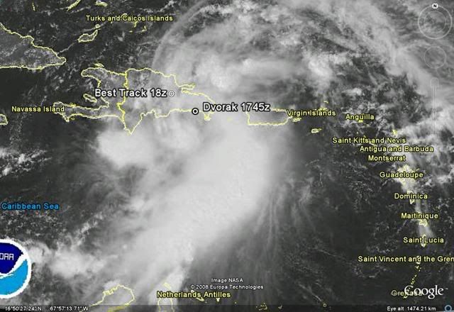
Re: ATL INVEST 93L: Discussion
SSD dvorak
23/1745 UTC 18.4N 69.1W T2.0/2.0 93L -- Atlantic Ocean
http://www.ssd.noaa.gov/PS/TROP/positions.html
Best Track
AL, 93, 2008092318, , BEST, 0, 190N, 700W, 30, 1008, DB,
ftp://ftp.tpc.ncep.noaa.gov/atcf/tcweb/
Pick your center.
23/1745 UTC 18.4N 69.1W T2.0/2.0 93L -- Atlantic Ocean
http://www.ssd.noaa.gov/PS/TROP/positions.html
Best Track
AL, 93, 2008092318, , BEST, 0, 190N, 700W, 30, 1008, DB,
ftp://ftp.tpc.ncep.noaa.gov/atcf/tcweb/
Pick your center.
0 likes
-
Matt-hurricanewatcher
Re: ATL INVEST 93L: Discussion
cycloneye wrote:23/1745 UTC 18.4N 69.1W T2.0/2.0 93L -- Atlantic Ocean
Best Track
AL, 93, 2008092318, , BEST, 0, 190N, 700W, 30, 1008, DB,
Pick your center.
The visible shows a LLC near 20.2/70.8. I see nothing at 19/70 at all...In fact I believe the LLC could be developing near 18.3/69.2 near the SAB thinking.
0 likes
-
Blown Away
- S2K Supporter
- Posts: 10253
- Joined: Wed May 26, 2004 6:17 am
Re: ATL INVEST 93L: Discussion
cycloneye wrote:SSD dvorak
23/1745 UTC 18.4N 69.1W T2.0/2.0 93L -- Atlantic Ocean
http://www.ssd.noaa.gov/PS/TROP/positions.html
Best Track
AL, 93, 2008092318, , BEST, 0, 190N, 700W, 30, 1008, DB,
ftp://ftp.tpc.ncep.noaa.gov/atcf/tcweb/
Pick your center.
I pick door #1, either way 93L goes N.
0 likes
-
Lowpressure

- S2K Supporter
- Posts: 2032
- Age: 59
- Joined: Sun Sep 14, 2003 9:17 am
- Location: Charlotte, North Carolina
Re: ATL INVEST 93L: Discussion
I agree door #1, man, DR/Haiti can not catch a break this year.
0 likes

Re: ATL INVEST 93L: Discussion
Lowpressure wrote:I agree door #1, man, DR/Haiti can not catch a break this year.
If it goes NW it would be the worst scenario for Haiti, specially for the citizens of Gonaives and Cabaret..
0 likes

Re: ATL INVEST 93L: Discussion
"Anytime" is becoming something in the lines of "we don't know when."
Again, per Hawkeye of MASH, "Anytime? How many minutes in an anytime, Frank?"
And, per Mike Seaver of Growing Pains, "They don't have a clue..."
Can't you tell that I stay home a lot?
LOL
P.S. I'm sure the NHC would prefer something more defined, but, this is not a well-defined system, after all, so, "anytime" is about the best anyone can do...
P.P.S. I read hail2's post after posting mine - I agree, it's a terrible situation for them...
0 likes
-
Blown Away
- S2K Supporter
- Posts: 10253
- Joined: Wed May 26, 2004 6:17 am
Re: ATL INVEST 93L: Discussion
The broad circulation is becoming more clear near 18.4N/69.1W. Relocation a little further S, can't see how that changes the overall thinking with 93L going N.
http://www.ssd.noaa.gov/goes/flt/t1/loop-vis.html
http://www.ssd.noaa.gov/goes/flt/t1/loop-vis.html
0 likes
-
Lowpressure
- S2K Supporter
- Posts: 2032
- Age: 59
- Joined: Sun Sep 14, 2003 9:17 am
- Location: Charlotte, North Carolina
Re: ATL INVEST 93L: Discussion
Loop above looks to be starting to wrap and turn more than just boiling. The 18.4 70.1 area looks to be the eventual winner as far as LLC.
0 likes
-
Lowpressure
- S2K Supporter
- Posts: 2032
- Age: 59
- Joined: Sun Sep 14, 2003 9:17 am
- Location: Charlotte, North Carolina
Re: ATL INVEST 93L: Discussion
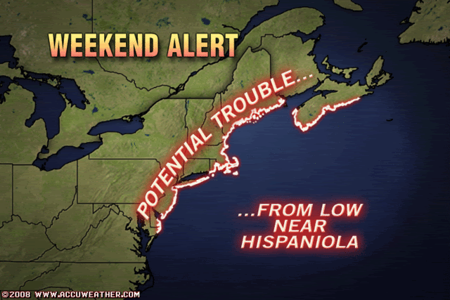
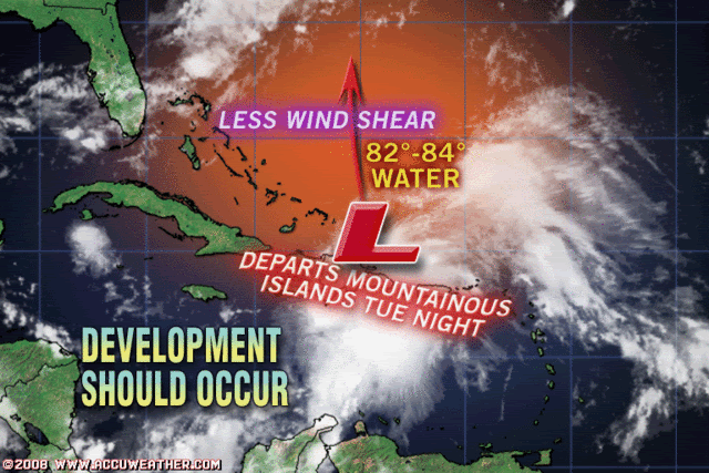
The Accuweather photos above mention nothing abouth the potential interaction with the coastal low. These two lows will interact somehow.
0 likes
-
wxman57

- Moderator-Pro Met

- Posts: 23175
- Age: 68
- Joined: Sat Jun 21, 2003 8:06 pm
- Location: Houston, TX (southwest)
Re: ATL INVEST 93L: Discussion
MLC is definitely south of the DR, but not much evidence of anything at the surface yet. Just calm to light easterly winds along the south coast of the DR. That would be the place to watch for surface development, though. Track to the north (eventually) still looks good.

0 likes
-
Rincon
- S2K Supporter
- Posts: 19
- Joined: Tue May 20, 2008 1:39 pm
- Location: Rincon, Puerto Rico
- Contact:
Re: ATL INVEST 93L: Discussion
Backdoor just pressing onshore here on the West Coast in Rincon, PR. Winds South. Cam and weather station if anyone is interested. Cam faces SouthWest. Station is a Davis VP2 wireless mounted on prperty.
I will keep you all posted on any big news. For now looks like more rain. We were spared yesterady here in the Northwest. .59 on my station.
http://www.rinconadventure.com/Weather/wxindex.php
I will keep you all posted on any big news. For now looks like more rain. We were spared yesterady here in the Northwest. .59 on my station.
http://www.rinconadventure.com/Weather/wxindex.php
0 likes
Re: ATL INVEST 93L: Discussion
Nor do they mention that water temps are in the 60s from off the Jersey shore and points north....important to note, in addition to the 82-84 degree water they point out east of the bahamas.
Lowpressure wrote:The Accuweather photos above mention nothing abouth the potential interaction with the coastal low. These two lows will interact somehow.
0 likes
-
Ed Mahmoud
Re: ATL INVEST 93L: Discussion
jinftl wrote:Nor do they mention that water temps are in the 60s from off the Jersey shore and points north....important to note, in addition to the 82-84 degree water they point out east of the bahamas.Lowpressure wrote:The Accuweather photos above mention nothing abouth the potential interaction with the coastal low. These two lows will interact somehow.
Well, this isn't a Cat 5, but the 1938 storm, a Cat 5 East of Florida which made landfall as a Cat 3, 1985's Gloria, and 1976's Belle would indicate a storm drops about 2 Saffir-Simpson categories if moving fast enough, as extra-tropical processes partially compensate for cooler SSTs.
0 likes
-
carolina_73

- Tropical Storm

- Posts: 148
- Joined: Wed Jul 23, 2008 1:30 am
Re: ATL INVEST 93L: Discussion
Lowpressure wrote:The Accuweather photos above mention nothing abouth the potential interaction with the coastal low. These two lows will interact somehow.
The perfect storm part 2???
0 likes
Re: ATL INVEST 93L: Discussion
Fairly sure radar is confirming a rare relocation to the south where everyone is seeing it.
Should jack north out of that location in response to the trough. Stall, relocation, exit north.
Should jack north out of that location in response to the trough. Stall, relocation, exit north.
0 likes
-
vbhoutex

- Storm2k Executive
- Posts: 29149
- Age: 74
- Joined: Wed Oct 09, 2002 11:31 pm
- Location: Cypress, TX
- Contact:
Re:
HURAKAN wrote:vbhoutex, I agree. A very pronounced MLC south of the DR. That was what I was looking in the radar a few hours ago. Jeff Masters says in his blog that a relocation of the center to the south of the DR shouldn't be expected, but I think that if the convection continues to fire around the MLC, then a relocation is certainly very possible.
Masters: "The heavy thunderstorm activity is mostly to the south and east, but there are no signs that the center of 93L will relocate itself under the heavy thunderstorm activity, and I do not expect this to happen. The thunderstorm activity is displaced to the southeast because strong upper-level winds from the west are pushing the thunderstorms away from the west side of the storm. The wind shear remains about 15 knots, which is marginal for tropical storm development."
Link: http://www.wunderground.com/blog/JeffMa ... amp=200809
Well, Master's explains a little of what I was too lazy to look up. I did not realize how much shear there was. I couldn't understand why the storms were staying to the East of the LLC even though that is a classic reason. Now it makes more sense. Maybe the mlc will move N and catch up to the LLC or what is left of it. I sure hope so for the sake of everyone in the islands.
0 likes
Who is online
Users browsing this forum: No registered users and 33 guests