ATL Tropical Storm Kyle: Recon Discussion
Moderator: S2k Moderators


Re: ATL INVEST 93L: Recon Discussion
Pojo, was that Boca Chica Naval Air Station? Never heard of recon flying out of there before.
0 likes
Re: ATL INVEST 93L: Recon Discussion
Recurve wrote:Pojo, was that Boca Chica Naval Air Station? Never heard of recon flying out of there before.
yes... we were there on a cross country and the storm mission happened to come up..... It saved them 2.5 hours flying from NAS Key West instead of Keesler.
0 likes

-
Ed Mahmoud
Re: ATL INVEST 93L: Recon Discussion
000200 2115N 06916W 7611 02406 0046 +133 +119 323007 008 034 000 03
000230 2116N 06914W 7614 02404 0045 +134 +129 306006 010 044 007 00
000300 2118N 06913W 7610 02409 0040 +132 +132 217002 005 046 008 00
000330 2119N 06911W 7581 02440 0015 +128 +128 148005 010 040 002 00
000400 2120N 06909W 7571 02454 9983 +129 +129 132014 015 040 003 00
000430 2122N 06908W 7574 02453 9970 +130 +130 130014 015 999 999 03
000500 2124N 06908W 7580 02444 0047 +133 +127 146018 018 036 002 00
000530 2126N 06908W 7597 02427 0051 +131 +126 141016 017 033 000 03
That 997 looks a little funky to me.
Last edited by Ed Mahmoud on Wed Sep 24, 2008 8:59 pm, edited 1 time in total.
0 likes
-
CrazyC83
- Professional-Met

- Posts: 34315
- Joined: Tue Mar 07, 2006 11:57 pm
- Location: Deep South, for the first time!
Re: ATL INVEST 93L: Recon Discussion
Ed Mahmoud wrote:000200 2115N 06916W 7611 02406 0046 +133 +119 323007 008 034 000 03
000230 2116N 06914W 7614 02404 0045 +134 +129 306006 010 044 007 00
000300 2118N 06913W 7610 02409 0040 +132 +132 217002 005 046 008 00
000330 2119N 06911W 7581 02440 0015 +128 +128 148005 010 040 002 00
000400 2120N 06909W 7571 02454 9983 +129 +129 132014 015 040 003 00
000430 2122N 06908W 7574 02453 9970 +130 +130 130014 015 999 999 03
000500 2124N 06908W 7580 02444 0047 +133 +127 146018 018 036 002 00
000530 2126N 06908W 7597 02427 0051 +131 +126 141016 017 033 000 03
That 997 looks a little funky to me.
It has been disregarded. The best estimate is 1004mb based on a subsequent pass (the third pass missed the center completely to the north).
0 likes
-
Ed Mahmoud
Re: ATL INVEST 93L: Recon Discussion
CrazyC83 wrote:Ed Mahmoud wrote:000200 2115N 06916W 7611 02406 0046 +133 +119 323007 008 034 000 03
000230 2116N 06914W 7614 02404 0045 +134 +129 306006 010 044 007 00
000300 2118N 06913W 7610 02409 0040 +132 +132 217002 005 046 008 00
000330 2119N 06911W 7581 02440 0015 +128 +128 148005 010 040 002 00
000400 2120N 06909W 7571 02454 9983 +129 +129 132014 015 040 003 00
000430 2122N 06908W 7574 02453 9970 +130 +130 130014 015 999 999 03
000500 2124N 06908W 7580 02444 0047 +133 +127 146018 018 036 002 00
000530 2126N 06908W 7597 02427 0051 +131 +126 141016 017 033 000 03
That 997 looks a little funky to me.
It has been disregarded. The best estimate is 1004mb based on a subsequent pass (the third pass missed the center completely to the north).
Makes sense. I was comparing recon to 6 hour prediction from 18Z GFDL, which was 1001 mb and 57 knots at 35 meters. It confused me for a few minutes to see pressure even lower than the GFDL prediction with no winds to match.
0 likes
-
bvigal

- S2K Supporter

- Posts: 2276
- Joined: Sun Jul 24, 2005 8:49 am
- Location: British Virgin Islands
- Contact:
Re: ATL INVEST 93L: Recon Discussion
So... am I reading this correctly? They found the center with little wind, and they are finished?
0 likes
-
HURAKAN

- Professional-Met
- Posts: 46084
- Age: 39
- Joined: Thu May 20, 2004 4:34 pm
- Location: Key West, FL
- Contact:
319
NOUS42 KNHC 251500
WEATHER RECONNAISSANCE FLIGHTS
CARCAH, NATIONAL HURRICANE CENTER, MIAMI, FL.
1100 AM EDT THU 25 SEPTEMBER 2008
SUBJECT: TROPICAL CYCLONE PLAN OF THE DAY (TCPOD)
VALID 26/1100Z TO 27/1100Z SEPTEMBER 2008
TCPOD NUMBER.....08-117
I. ATLANTIC REQUIREMENTS
1.LOW (OFF CAROLINA COAST)
FLIGHT ONE -- TEAL 73
A. 26/1200, 1800Z
B. AFXXX 04GGA LOW
C. 26/0830Z
D. 33.3N 78.7W
E. 26/1100Z TO 26/1800Z
F. SFC TO 10,000 FT
2.SUSPECT AREA (NORTH OF HISPANIOLA)
FLIGHT ONE -- TEAL 72
A. 26/1800Z
B. AFXXX 12FFA CYCLONE
C. 26/1500Z
D. 29.5N 69.5W
E. 26/1700Z TO 26/21030Z
F. SFC TO 10,000 FT
FLIGHT TWO -- TEAL 70
A. 27/0600Z
B. AFXXX 13FFA CYCLONE
C. 27/0200Z
D. 33.5N 69.5W
E. 27/0500Z TO 27/0900Z
F. SFC TO 10,000 FT
3.OUTLOOK FOR SUCCEEDING DAY: NEGATIVE OFF THE CAROLINA'S.
THAT SYSTEM SHOULD BE OVER LAND. CONTINUE 12-HRLY FIXES
ON SYSTEM IN THE WESTERN ATLANTIC IF STILL A THREAT. P-3
RESEARCH MISSIONS EVERY 12 HRS.
4.THE P-3'S HAVE BEEN TASKED FOR RESEARCH MISSIONS TAKING
OFF AT 26/2000Z AND 27/0800Z INTO THESE SYSTEMS.
II. PACIFIC REQUIREMENTS
1. NEGATIVE RECONNAISSANCE REQUIREMENTS.
2. SUCCEEDING DAY OUTLOOK.....NEGATIVE.
JWP
0 likes

-
cycloneye

- Admin

- Posts: 149276
- Age: 69
- Joined: Thu Oct 10, 2002 10:54 am
- Location: San Juan, Puerto Rico
Re: ATL INVEST 93L: Recon Discussion
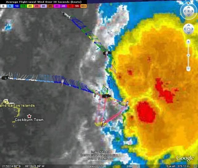
They found a closed circulation.
Product: Air Force Vortex Message (URNT12 KNHC)
Transmitted: 25th day of the month at 18:19Z
Aircraft: Air Force Aircraft (Last 3 digits of the tail number are 302)
Mission Purpose: Investigate fifth suspect area (in the North Atlantic basin)
Mission Number: 8
Observation Number: 04
A. Time of Center Fix: 25th day of the month at 17:34:00Z
B. Center Fix Coordinates: 22°53'N 68°36'W (22.8833N 68.6W) (View map)
B. Center Fix Location: 190 miles (306 km) to the ENE (59°) from Cockburn Town, Turks and Caicos Islands (GBR).
C. Minimum Height at Standard Level: Not Available
D. Estimated (by SFMR or visually) Maximum Surface Wind: 25kts (~ 28.8mph)
E. Location of the Estimated Maximum Surface Wind: 32 nautical miles (37 statute miles) to the SW (235°) of center fix
F. Maximum Flight Level Wind Inbound: From 330° at 19kts (From the NNW at ~ 21.9mph)
G. Location of Maximum Flight Level Wind Inbound: 33 nautical miles (38 statute miles) to the SW (233°) of center fix
H. Minimum Sea Level Pressure: 1003mb (29.62 inHg) - Extrapolated
I. Maximum Flight Level Temp & Pressure Altitude Outside Eye: 24°C (75°F) at a pressure alt. of 220m (722ft)
J. Maximum Flight Level Temp & Pressure Altitude Inside Eye: 24°C (75°F) at a pressure alt. of 222m (728ft)
K. Dewpoint Temp (collected at same location as temp inside eye): 22°C (72°F)
K. Sea Surface Temp (collected at same location as temp inside eye): Not Available
L. Eye Character: Not Available
M. Eye Shape: Not Available
N. Fix Determined By: Penetration, Wind and Pressure
N. Fix Level: 1,500 feet
O. Navigation Fix Accuracy: 0.02 nautical miles
O. Meteorological Accuracy: 8 nautical miles
Remarks Section - Remarks That Were Decoded...
Maximum Flight Level Wind: 19kts (~ 21.9mph) in the southwest quadrant at 17:21:10Z
Maximum Flight Level Wind Outbound: 51kts (~ 58.7mph) in the northeast quadrant at 0:00:00Z
Maximum Flight Level Temp: 25°C (77°F) which was observed 11 nautical miles (13 statute miles) to the SSW (209°) from the flight level center
Remarks Section - Additional Remarks...
SLP EXTRAP FROM BELOW 1500 FT
wind center elongated SW to NW
sfc center near 22 deg 47 min N 68 deg 37 min W
0 likes
Who is online
Users browsing this forum: No registered users and 91 guests