ATL: Tropical Storm Kyle : Discussion
Moderator: S2k Moderators


-
HURAKAN

- Professional-Met

- Posts: 46084
- Age: 39
- Joined: Thu May 20, 2004 4:34 pm
- Location: Key West, FL
- Contact:
Re: ATL INVEST 93L: Discussion
Best Track 0z:
AL, 93, 2008092400, , BEST, 0, 184N, 696W, 30, 1008
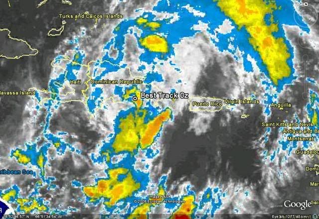
AL, 93, 2008092400, , BEST, 0, 184N, 696W, 30, 1008
0 likes
-
cycloneye

- Admin

- Posts: 149568
- Age: 69
- Joined: Thu Oct 10, 2002 10:54 am
- Location: San Juan, Puerto Rico
Re: ATL INVEST 93L: Discussion

At the rate this is going,it will never become a Tropical Cyclone.
0 likes
-
Gustywind

- Category 5

- Posts: 12334
- Joined: Mon Sep 03, 2007 7:29 am
- Location: Baie-Mahault, GUADELOUPE
Re: ATL INVEST 93L: Discussion
cycloneye wrote:
At the rate this is going,it will never become a Tropical Cyclone.
000
AXNT20 KNHC 241018
TWDAT
TROPICAL WEATHER DISCUSSION
NWS TPC/NATIONAL HURRICANE CENTER MIAMI FL
805 AM EDT WED SEP 24 2008
TROPICAL WEATHER DISCUSSION FOR NORTH AMERICA...CENTRAL
AMERICA...GULF OF MEXICO...CARIBBEAN SEA...NORTHERN SECTIONS
OF SOUTH AMERICA...AND ATLANTIC OCEAN TO THE AFRICAN COAST
FROM THE EQUATOR TO 32N. THE FOLLOWING INFORMATION IS BASED
ON SATELLITE IMAGERY...METEOROLOGICAL ANALYSIS...WEATHER
OBSERVATIONS...AND RADAR.
BASED ON 0600 UTC SURFACE ANALYSIS AND SATELLITE IMAGERY THROUGH
0945 UTC.
...SPECIAL FEATURES...
A BROAD AREA OF LOW PRESSURE IS ANALYZED AS A 1006 MB LOW INLAND
OVER THE DOMINICAN REPUBLIC NEAR 18.5N70W AND CONTINUES TO BRING
HEAVY RAINS TO HISPANIOLA AND THE ADJACENT WATERS. THIS SYSTEM
IS INTERACTING WITH LAND AND HAS NOT YET DEVELOPED A WELL
DEFINED SURFACE CIRCULATION BUT ATMOSPHERIC CONDITIONS REMAIN
FAVORABLE FOR DEVELOPMENT AND A TROPICAL DEPRESSION COULD FORM
LATER TODAY OR TONIGHT AS THIS SYSTEM MOVES N OF HISPANIOLA.
CLUSTERS OF SCATTERED MODERATE/ISOLATED STRONG CONVECTION ARE
FROM 14N-18N BETWEEN 68W-71W. SCATTERED SHOWERS/ISOLATED
THUNDERSTORMS ARE FROM 18N-23N BETWEEN 61W-73W INCLUDING ISLANDS
FROM THE LEEWARDS TO THE TURKS AND CAICOS.
0 likes
-
Gustywind
- Category 5
- Posts: 12334
- Joined: Mon Sep 03, 2007 7:29 am
- Location: Baie-Mahault, GUADELOUPE
000
ABNT20 KNHC 240539
TWOAT
TROPICAL WEATHER OUTLOOK
NWS TPC/NATIONAL HURRICANE CENTER MIAMI FL
200 AM EDT WED SEP 24 2008
FOR THE NORTH ATLANTIC...CARIBBEAN SEA AND THE GULF OF MEXICO...
THE BROAD AREA OF LOW PRESSURE OVER HISPANIOLA CONTINUES TO GENERATE
A LARGE AREA OF CLOUDINESS AND SHOWERS EXTENDING NORTHWARD FROM THE
NORTHEASTERN CARIBBEAN SEA...ACROSS HISPANIOLA AND PUERTO
RICO...AND INTO THE WESTERN ATLANTIC. THIS SYSTEM IS INTERACTING
WITH LAND AND HAS NOT YET DEVELOPED A WELL-DEFINED SURFACE
CIRCULATION...BUT ATMOSPHERIC CONDITIONS REMAIN FAVORABLE FOR
DEVELOPMENT AND A TROPICAL DEPRESSION COULD FORM LATER TODAY OR
TONIGHT AS THIS SYSTEM MOVES NORTH OF HISPANIOLA. REGARDLESS OF
DEVELOPMENT...HEAVY RAINFALL AND THE POTENTIAL FOR LIFE-THREATENING
FLASH FLOODS AND MUD SLIDES ARE EXPECTED TO CONTINUE OVER
HISPANIOLA...PUERTO RICO...AND THE VIRGIN ISLANDS TODAY. HEAVY
RAINS COULD ALSO SPREAD NORTHWARD OVER THE TURKS AND CAICOS ISLANDS
AND THE SOUTHEASTERN BAHAMAS LATER TODAY OR TONIGHT.
INTERESTS IN PUERTO RICO...THE VIRGIN ISLANDS...THE DOMINICAN
REPUBLIC...HAITI...THE TURKS AND CAICOS ISLANDS...AND THE
SOUTHEASTERN BAHAMAS SHOULD CONTINUE TO MONITOR THE PROGRESS OF
THIS SYSTEM AND PRODUCTS ISSUED BY THEIR RESPECTIVE WEATHER
FORECAST OFFICES.
ELSEWHERE...TROPICAL CYCLONE FORMATION IS NOT EXPECTED DURING THE
NEXT 48 HOURS.
$$
FORECASTER RHOME
0 likes
-
cycloneye
- Admin
- Posts: 149568
- Age: 69
- Joined: Thu Oct 10, 2002 10:54 am
- Location: San Juan, Puerto Rico
Re: ATL INVEST 93L: Discussion
The system off the Carolinas looks much better than the real mess that 93L is and it supports my thinking that it will never be a Tropical Cyclone.


0 likes
-
cycloneye
- Admin
- Posts: 149568
- Age: 69
- Joined: Thu Oct 10, 2002 10:54 am
- Location: San Juan, Puerto Rico
Re: ATL INVEST 93L: Discussion
561
ABNT20 KNHC 241136
TWOAT
TROPICAL WEATHER OUTLOOK
NWS TPC/NATIONAL HURRICANE CENTER MIAMI FL
800 AM EDT WED SEP 24 2008
FOR THE NORTH ATLANTIC...CARIBBEAN SEA AND THE GULF OF MEXICO...
 SHOWERS AND THUNDERSTORMS ASSOCIATED WITH THE BROAD AREA OF LOW
PRESSURE OVER HISPANIOLA HAVE DECREASED SOMEWHAT THIS MORNING.
THIS SYSTEM DOES NOT HAVE A WELL-DEFINED SURFACE CIRCULATION...BUT
ATMOSPHERIC CONDITIONS APPEAR TO BE FAVORABLE FOR TROPICAL CYCLONE
FORMATION AS IT MOVES GENERALLY NORTHWARD...AND AWAY FROM
HISPANIOLA...TODAY AND TONIGHT. THERE IS STILL THE POTENTIAL FOR
HEAVY RAINFALL AND LIFE-THREATENING FLASH FLOODS AND MUD SLIDES
OVER HISPANIOLA DURING THE NEXT DAY OR SO.
A LOW PRESSURE SYSTEM IS LOCATED A COUPLE HUNDRED MILES SOUTHEAST OF
WILMINGTON NORTH CAROLINA. ALTHOUGH THIS LOW IS CURRENTLY
ASSOCIATED WITH A FRONTAL ZONE...IT HAS THE POTENTIAL TO DEVELOP
INTO A TROPICAL OR SUBTROPICAL CYCLONE AS IT MOVES SLOWLY WESTWARD
OVER THE NEXT DAY OR TWO. HIGH SURF AND DANGEROUS RIP CURRENTS
ASSOCIATED WITH THIS SYSTEM WILL AFFECT PORTIONS OF THE U.S. EAST
COAST FOR THE NEXT SEVERAL DAYS. CONSULT STATEMENTS FROM LOCAL
NATIONAL WEATHER SERVICE FORECAST OFFICES FOR ADDITIONAL
INFORMATION.
ELSEWHERE...TROPICAL CYCLONE FORMATION IS NOT EXPECTED DURING THE
NEXT 48 HOURS.
$$
FORECASTER PASCH/BERG
ABNT20 KNHC 241136
TWOAT
TROPICAL WEATHER OUTLOOK
NWS TPC/NATIONAL HURRICANE CENTER MIAMI FL
800 AM EDT WED SEP 24 2008
FOR THE NORTH ATLANTIC...CARIBBEAN SEA AND THE GULF OF MEXICO...
PRESSURE OVER HISPANIOLA HAVE DECREASED SOMEWHAT THIS MORNING.
THIS SYSTEM DOES NOT HAVE A WELL-DEFINED SURFACE CIRCULATION...BUT
ATMOSPHERIC CONDITIONS APPEAR TO BE FAVORABLE FOR TROPICAL CYCLONE
FORMATION AS IT MOVES GENERALLY NORTHWARD...AND AWAY FROM
HISPANIOLA...TODAY AND TONIGHT. THERE IS STILL THE POTENTIAL FOR
HEAVY RAINFALL AND LIFE-THREATENING FLASH FLOODS AND MUD SLIDES
OVER HISPANIOLA DURING THE NEXT DAY OR SO.
A LOW PRESSURE SYSTEM IS LOCATED A COUPLE HUNDRED MILES SOUTHEAST OF
WILMINGTON NORTH CAROLINA. ALTHOUGH THIS LOW IS CURRENTLY
ASSOCIATED WITH A FRONTAL ZONE...IT HAS THE POTENTIAL TO DEVELOP
INTO A TROPICAL OR SUBTROPICAL CYCLONE AS IT MOVES SLOWLY WESTWARD
OVER THE NEXT DAY OR TWO. HIGH SURF AND DANGEROUS RIP CURRENTS
ASSOCIATED WITH THIS SYSTEM WILL AFFECT PORTIONS OF THE U.S. EAST
COAST FOR THE NEXT SEVERAL DAYS. CONSULT STATEMENTS FROM LOCAL
NATIONAL WEATHER SERVICE FORECAST OFFICES FOR ADDITIONAL
INFORMATION.
ELSEWHERE...TROPICAL CYCLONE FORMATION IS NOT EXPECTED DURING THE
NEXT 48 HOURS.
$$
FORECASTER PASCH/BERG
0 likes
-
DESTRUCTION5

- Category 5
- Posts: 4430
- Age: 44
- Joined: Wed Sep 03, 2003 11:25 am
- Location: Stuart, FL
-
cycloneye
- Admin
- Posts: 149568
- Age: 69
- Joined: Thu Oct 10, 2002 10:54 am
- Location: San Juan, Puerto Rico
Re: ATL INVEST 93L: Discussion
Visible pic of the mess that 93L is.This was supposed to be TS Kyle by now if you haved followed the models a few days ago.But it looks like now Kyle may be the new invest 94L instead of this.

0 likes
-
wxman57

- Moderator-Pro Met

- Posts: 23175
- Age: 68
- Joined: Sat Jun 21, 2003 8:06 pm
- Location: Houston, TX (southwest)
Re: ATL INVEST 93L: Discussion
Looks a lot less likely that 93L will ever develop now. Moisture is being strung out to the north as the trof/low deepens off the East U.S. Coast. That low should move inland tomorrow night as a subtropical storm. Whether or not the NHC names it, it'll produce 45-60 mph winds on the beaches from NC through Maryland tonight/tomorrow morning.
0 likes

Re: ATL INVEST 93L: Discussion
wxman57 wrote:Looks a lot less likely that 93L will ever develop now. Moisture is being strung out to the north as the trof/low deepens off the East U.S. Coast. That low should move inland tomorrow night as a subtropical storm. Whether or not the NHC names it, it'll produce 45-60 mph winds on the beaches from NC through Maryland tonight/tomorrow morning.
The Year of the Unnamed Disaster Lows?
0 likes
-
cycloneye
- Admin
- Posts: 149568
- Age: 69
- Joined: Thu Oct 10, 2002 10:54 am
- Location: San Juan, Puerto Rico
Re: ATL INVEST 93L: Discussion
12:00 UTC Best Track has it in Atlantic Waters north of the Dominican Republic.
AL, 93, 2008092412, , BEST, 0, 205N, 701W, 30, 1005, DB
AL, 93, 2008092412, , BEST, 0, 205N, 701W, 30, 1005, DB
0 likes
-
deltadog03

- Professional-Met
- Posts: 3580
- Joined: Tue Jul 05, 2005 6:16 pm
- Location: Macon, GA
-
Ed Mahmoud
Re: ATL INVEST 93L: Discussion
WV loop
Still enough separation between 93L and 94L that I, in my unprofessional and highly unofficial opinion, believe there is still a short window of opportunity for this to develop.
IMHO, the patient is sickly, but not dead.
I am not a doctor, and do not play one on TV.
Still enough separation between 93L and 94L that I, in my unprofessional and highly unofficial opinion, believe there is still a short window of opportunity for this to develop.
IMHO, the patient is sickly, but not dead.
I am not a doctor, and do not play one on TV.
0 likes
-
stormy1970al

- Tropical Storm

- Posts: 158
- Age: 56
- Joined: Sat May 31, 2008 12:54 pm
- Location: Fairhope AL
Re: ATL INVEST 93L: Discussion
dixiebreeze wrote:Lowpressure wrote:The Accuweather photos above mention nothing abouth the potential interaction with the coastal low. These two lows will interact somehow.
This gives me an eerie feeling, having just watched The Perfect Storm on TV.
I was thinking the same thing when I read the above. Scary thought.
0 likes
-
HURAKAN
- Professional-Met
- Posts: 46084
- Age: 39
- Joined: Thu May 20, 2004 4:34 pm
- Location: Key West, FL
- Contact:
Re: ATL INVEST 93L: Discussion
Jeff Masters: http://www.wunderground.com/blog/JeffMa ... amp=200809
It's tough to tell what tropical disturbance 93L is up to, as the storm has significantly deteriorated overnight. Dominican Republic radar is down, and visible satellite loops show little heavy thunderstorm activity or organization to the cloud pattern. However, pressures at Punta Cana on the eastern tip of the Dominican Republic are the lowest they've been for the week--1006 mb. I expect 93L will regenerate north of the Dominican Republic today and spread heavy rains to that country and Puerto Rico this afternoon and Thursday.
In the Dominican Republic, heavy rain has been limited to the extreme eastern end, near Punta Cana, where satellite estimates indicate up to ten inches of rain has fallen. Rainfall in the capital, Santo Domingo, has been about three inches, according to three personal weather stations there. Additional heavy rains of 2-4 inches are likely today through Thursday in portions of the Dominican Republic.
Haiti has thus far escaped heavy rains from 93L, and I expect only an additional 2-4 inches will there. Heaviest rains in the Turks and Caicos islands and southeastern Bahamas should be in the 2-4 inch range. Western Puerto Rico may receive an additional 2-4 inches, as well.
The forecast
Wind shear remains near 15 knots. The current wind shear forecast from the SHIPS model keeps the shear at 15-25 knots for the remainder of the week. The computer models take 93L northwards to a landfall in New England or Nova Scotia on Saturday or Sunday, and I doubt the storm would hit as anything stronger than a 55 mph tropical storm. The storm is too disorganized at present, and there is too much shear in the forecast to allow 93L to become a hurricane.
0 likes
Re: ATL INVEST 93L: Discussion
The Florida posters can attest to the cool dry air here.
93L stayed over Hispaniola too long.
SW Caribbean in a few weeks when the humidity rebounds.
93L stayed over Hispaniola too long.
SW Caribbean in a few weeks when the humidity rebounds.
0 likes
Who is online
Users browsing this forum: No registered users and 16 guests