ATL INVEST 94L: Discussion
Moderator: S2k Moderators


Re: ATL INVEST 94L: Discussion
it's frontal...can't have a STS with fronts attached to it
Last edited by Jam151 on Thu Sep 25, 2008 12:26 pm, edited 1 time in total.
0 likes
-
Category 5

- Category 5

- Posts: 10074
- Age: 36
- Joined: Sun Feb 11, 2007 10:00 pm
- Location: New Brunswick, NJ
- Contact:
Re:
CrazyC83 wrote:I'm thinking this will be left alone and declared an unnamed (sub)tropical storm in the post-analysis.
It's not Subtropical now and might not have enough time. This will just be considered a Coastal Storm.
0 likes
-
Category 5
- Category 5
- Posts: 10074
- Age: 36
- Joined: Sun Feb 11, 2007 10:00 pm
- Location: New Brunswick, NJ
- Contact:
Re: ATL INVEST 94L: Discussion
Ed Mahmoud wrote:it probably saves a lot of typing and coordination calls with local NWS offices to let it landfall as a warm core, non frontal 60 mph un-named extra-tropical storm.
Can we please stop bashing the NHC? Recon was out there and they didn't upgrade it. These people are some of the finest mets in the world, I think they know what there doing and wouldn't not upgrade out of laziness as you're suggesting.
0 likes
-
Ed Mahmoud
Re: ATL INVEST 94L: Discussion
I might have missed it looking at the HDOBs, but I didn't see wind/temp/dewpoint discontinuity near the center that suggests a surface front near the center. It seems, IMHO, to be on the cool side of whatever frontal boundary there is, but it has obviously fired enough thunderstorms to be warmer than its immediate environment.
A pro-met with the fancy GARP or AWIPs or whatever might be able to show where I'm wrong, by analyzing in a front near the center. If the temps and dewpoints on either side of the occlusion are similar, and there isn't much of a wind shift, the surface front isn't much of a front. Now, somewhere aloft a cold front may be outrunning a warm front, but if there isn't a real surface front, than the surface system, IMHO, is a sub-tropical cyclone.
Just because an analyst at HPC working in coordination with NHC has a front drawn in doesn't prove there is a front there to my satisfaction, although, of course, said analyst would have the fancy tools and professional training I lack.
0 likes

-
Ed Mahmoud
Re: ATL INVEST 94L: Discussion
Category 5 wrote:Ed Mahmoud wrote:it probably saves a lot of typing and coordination calls with local NWS offices to let it landfall as a warm core, non frontal 60 mph un-named extra-tropical storm.
Can we please stop bashing the NHC? Recon was out there and they didn't upgrade it. These people are some of the finest mets in the world, I think they know what there doing and wouldn't not upgrade out of laziness as you're suggesting.
I know this board has a policy of not slagging on pro-mets, the NWS, TPC, etc., but if that extends to automatically agreeing with everything NHC says, because they are trained professionals, and most of us are just flat amateurs, well, not much point to even having discussions, and all the threads would just be pasting NHC advisories and satellite pictures, and not much more.
Again, I think something isn't quite right, but this does remind me of a pro-met's analogy to us, as non-medical professionals, standing around a doctor performing a cat scan on a patient and scoffing at his/her diagnosis. Maybe there really is a front in there somewhere, although if it is an occlusion, and there is no longer a distinct wind shift on the front at the surface, I'd argue there isn't a surface front anymore. But I would be arguing without the benefit of professional met training.
Anyway, I'd never suggest NHC doesn't upgrade systems at the behest of insurance companies, as I saw suggested on the 93L thread.
Last edited by Ed Mahmoud on Thu Sep 25, 2008 12:52 pm, edited 2 times in total.
0 likes
-
wxman57

- Moderator-Pro Met

- Posts: 23172
- Age: 68
- Joined: Sat Jun 21, 2003 8:06 pm
- Location: Houston, TX (southwest)
Re: ATL INVEST 94L: Discussion
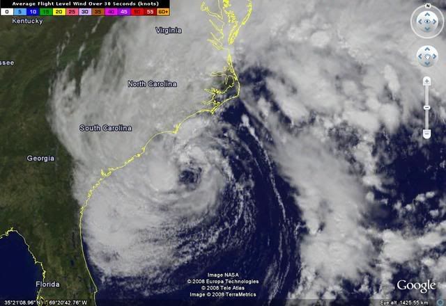
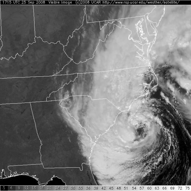
Looks like an occluded low now. Occluded front is along the coast. Note all the closed-cell strato-cu out over the water south of the low center. That's some fairly cold air over the warm water. Low 70s in SE GA and northern Florida in the early afternoon? Center only 100 miles from land now and moving at a bit over 8 kts. Should be inland late tonight. Nothing at all to be gained by giving it a name at this point.
0 likes

-
Category 5
- Category 5
- Posts: 10074
- Age: 36
- Joined: Sun Feb 11, 2007 10:00 pm
- Location: New Brunswick, NJ
- Contact:
Re: ATL INVEST 94L: Discussion
The door to this becoming an STS is not fully closed, but it's closing.
0 likes
-
Ed Mahmoud
Re: ATL INVEST 94L: Discussion
wxman57 wrote:Looks like an occluded low now. Occluded front is along the coast. Note all the closed-cell strato-cu out over the water south of the low center. That's some fairly cold air over the warm water. Low 70s in SE GA and northern Florida in the early afternoon? Center only 100 miles from land now and moving at a bit over 8 kts. Should be inland late tonight. Nothing at all to be gained by giving it a name at this point.
Is there still a surface wind shift near the center of this along the occluded front?
Is there some definition at to what altitude the cold front is catching the warm front at which an occluded front is not analyzed at the surface without a wind shift?
Inquiring minds and all that.
0 likes
-
Ed Mahmoud
Re: ATL INVEST 94L: Discussion
I do plead guilty to being influenced by JB, as I am a subscriber. I think I can safely post his latest update w/o violating my terms of service agreement
THURSDAY 1:30 PM
LOOK AT THIS:
P. AF307 02GGA INVEST OB 15 MAX FL WIND 59 KT N QUAD 15:13:20Z SLP EXTRAP FROM 850 MB SONDE RELEASED LATE IN EYE. SONDE SLP 996 MB, SFC WND 185 / 22 KTS ;
Now, why would the recon report take the time to tell TPC they released the dropsonde in the "eye"? Since when to non-tropical systems have 3C rises across the center at 5,000 and 10,000 feet, and why would the Recon people poke the hurricane center in the eye, by saying this had an eye, unless it had an eye BECAUSE IT IS A TROPICAL STORM.
By the way, it's down to 992 mb.
0 likes
-
Category 5
- Category 5
- Posts: 10074
- Age: 36
- Joined: Sun Feb 11, 2007 10:00 pm
- Location: New Brunswick, NJ
- Contact:
Re: ATL INVEST 94L: Discussion
Ed Mahmoud wrote:I do plead guilty to being influenced by JB, as I am a subscriber. I think I can safely post his latest update w/o violating my terms of service agreementTHURSDAY 1:30 PM
LOOK AT THIS:
P. AF307 02GGA INVEST OB 15 MAX FL WIND 59 KT N QUAD 15:13:20Z SLP EXTRAP FROM 850 MB SONDE RELEASED LATE IN EYE. SONDE SLP 996 MB, SFC WND 185 / 22 KTS ;
Now, why would the recon report take the time to tell TPC they released the dropsonde in the "eye"? Since when to non-tropical systems have 3C rises across the center at 5,000 and 10,000 feet, and why would the Recon people poke the hurricane center in the eye, by saying this had an eye, unless it had an eye BECAUSE IT IS A TROPICAL STORM.
By the way, it's down to 992 mb.
uhh, the "Blizzard of 06" had an "eye" as well.
0 likes
-
CrazyC83
- Professional-Met

- Posts: 34315
- Joined: Tue Mar 07, 2006 11:57 pm
- Location: Deep South, for the first time!
Re: ATL INVEST 94L: Discussion
Category 5 wrote:Ed Mahmoud wrote:I do plead guilty to being influenced by JB, as I am a subscriber. I think I can safely post his latest update w/o violating my terms of service agreementTHURSDAY 1:30 PM
LOOK AT THIS:
P. AF307 02GGA INVEST OB 15 MAX FL WIND 59 KT N QUAD 15:13:20Z SLP EXTRAP FROM 850 MB SONDE RELEASED LATE IN EYE. SONDE SLP 996 MB, SFC WND 185 / 22 KTS ;
Now, why would the recon report take the time to tell TPC they released the dropsonde in the "eye"? Since when to non-tropical systems have 3C rises across the center at 5,000 and 10,000 feet, and why would the Recon people poke the hurricane center in the eye, by saying this had an eye, unless it had an eye BECAUSE IT IS A TROPICAL STORM.
By the way, it's down to 992 mb.
uhh, the "Blizzard of 06" had an "eye" as well.
Eyes don't mean anything, since extratropical systems can also have eyes. The biggest argument is the warm core vs. frontal structure.
0 likes
-
Ed Mahmoud
Re: ATL INVEST 94L: Discussion
Category 5 wrote:Ed Mahmoud wrote:I do plead guilty to being influenced by JB, as I am a subscriber. I think I can safely post his latest update w/o violating my terms of service agreementTHURSDAY 1:30 PM
LOOK AT THIS:
P. AF307 02GGA INVEST OB 15 MAX FL WIND 59 KT N QUAD 15:13:20Z SLP EXTRAP FROM 850 MB SONDE RELEASED LATE IN EYE. SONDE SLP 996 MB, SFC WND 185 / 22 KTS ;
Now, why would the recon report take the time to tell TPC they released the dropsonde in the "eye"? Since when to non-tropical systems have 3C rises across the center at 5,000 and 10,000 feet, and why would the Recon people poke the hurricane center in the eye, by saying this had an eye, unless it had an eye BECAUSE IT IS A TROPICAL STORM.
By the way, it's down to 992 mb.
uhh, the "Blizzard of 06" had an "eye" as well.
Was the Blizzard over 26º water?
Anyway, if HPC analyzing an occluded front settles the matter, why doesn't NHC just cancel the mission now. What point is there flying around on a system they won't upgrade?
0 likes
-
Category 5
- Category 5
- Posts: 10074
- Age: 36
- Joined: Sun Feb 11, 2007 10:00 pm
- Location: New Brunswick, NJ
- Contact:
Re: ATL INVEST 94L: Discussion
Ed Mahmoud wrote:Anyway, if HPC analyzing an occluded front settles the matter, why doesn't NHC just cancel the mission now. What point is there flying around on a system they won't upgrade?
I give up

0 likes
-
Ed Mahmoud
Re: ATL INVEST 94L: Discussion
Category 5 wrote:Ed Mahmoud wrote:Anyway, if HPC analyzing an occluded front settles the matter, why doesn't NHC just cancel the mission now. What point is there flying around on a system they won't upgrade?
I give up
Can't answer the question? I'd give up as well.
0 likes
-
Lowpressure

- S2K Supporter

- Posts: 2032
- Age: 59
- Joined: Sun Sep 14, 2003 9:17 am
- Location: Charlotte, North Carolina
Re: ATL INVEST 94L: Discussion
Category 5 wrote:Ed Mahmoud wrote:Anyway, if HPC analyzing an occluded front settles the matter, why doesn't NHC just cancel the mission now. What point is there flying around on a system they won't upgrade?
I give up
I agree, what is the point? We can not change his mind, and if he is correct, we can not name it.
0 likes
-
Category 5
- Category 5
- Posts: 10074
- Age: 36
- Joined: Sun Feb 11, 2007 10:00 pm
- Location: New Brunswick, NJ
- Contact:
Re: ATL INVEST 94L: Discussion
Ed Mahmoud wrote:Category 5 wrote:Ed Mahmoud wrote:Anyway, if HPC analyzing an occluded front settles the matter, why doesn't NHC just cancel the mission now. What point is there flying around on a system they won't upgrade?
I give up
Can't answer the question? I'd give up as well.
If they haven't named it because it isn't subtropical isn't enough, nothing is.
0 likes
-
Ed Mahmoud
Re: ATL INVEST 94L: Discussion
Lowpressure wrote:Category 5 wrote:Ed Mahmoud wrote:Anyway, if HPC analyzing an occluded front settles the matter, why doesn't NHC just cancel the mission now. What point is there flying around on a system they won't upgrade?
I give up
I agree, what is the point? We can not change his mind, and if he is correct, we can not name it.
You can change my mind by showing me actual data that supports a surface front in/very near 94L.
But on previous page, I was informed this can't be a sub-tropical storm, because HPC has analyzed an occluded front through the center. Now, just because I didn't see evidence, in my amateur perusal of the high density obs, of a front in 94L doesn't mean it isn't there.
But I'm not kidding. If HPC analysis of a front is sufficient reason to not upgrade a warm core system that otherwise seems to meet the definition for a sub-tropical cyclone, than isn't recon pointless?
Anyway, as alluded by WxMan57, it is inland tonight, and coastal flood and wind advisories should keep most mariners from sailing into a 50 or 60 knot storm in small craft, so there isn't any real damage to ignoring this for twelve hours and insisting it is just an early season Nor'Easter.
0 likes
Who is online
Users browsing this forum: No registered users and 22 guests