
Still code yellow.
ZCZC MIATWOAT ALL
TTAA00 KNHC DDHHMM
TROPICAL WEATHER OUTLOOK
NWS TPC/NATIONAL HURRICANE CENTER MIAMI FL
800 PM EDT FRI OCT 03 2008
FOR THE NORTH ATLANTIC...CARIBBEAN SEA AND THE GULF OF MEXICO...
A BROAD AREA OF LOW PRESSURE CONTINUES TO PRODUCE WIDESPREAD
CLOUDINESS AND DISORGANIZED SHOWERS AND THUNDERSTORMS ACROSS
MUCH OF THE NORTHWESTERN CARIBBEAN SEA. ENVIRONMENTAL CONDITIONS
ARE CURRENTLY UNFAVORABLE...AND LITTLE DEVELOPMENT IS EXPECTED
AS THE SYSTEM DRIFTS WESTWARD DURING THE NEXT COUPLE OF DAYS.
A WESTWARD-MOVING TROPICAL WAVE INTERACTING WITH AN UPPER-LEVEL
LOW IS PRODUCING A LARGE AREA OF CLOUDINESS AND SCATTERED SHOWERS
ACROSS THE WINDWARD ISLANDS AND ADJACENT ATLANTIC AND EASTERN
CARIBBEAN WATERS. SHOWER ACTIVITY HAS DECREASED THIS EVENING...AND
NO SIGNIFICANT DEVELOPMENT IS EXPECTED AS THE SYSTEM MOVES WESTWARD
OR WEST-NORTHWESTWARD DURING THE NEXT TWO DAYS.
ELSEWHERE...TROPICAL CYCLONE FORMATION IS NOT EXPECTED DURING THE
NEXT 48 HOURS.
$$
FORECASTER STEWART
Area Of Disturbed Weather In NW Caribbean (Is Invest 96L)
Moderator: S2k Moderators
Forum rules

The posts in this forum are NOT official forecasts and should not be used as such. They are just the opinion of the poster and may or may not be backed by sound meteorological data. They are NOT endorsed by any professional institution or STORM2K. For official information, please refer to products from the National Hurricane Center and National Weather Service.
-
MiamiensisWx
Re: Area Of Disturbed Weather In NW Caribbean.
boca wrote:Its interesting that the NHC forecasts this area to move west against climatology which would normally favor a north or northeast direction.I'm assuming that their taking into account the high pressure building in would force this westward into the Yucatan.So far I don't see any indication of westward movement.
Actually, the bolded portion represents a common egregious assumption. Florida and the eastern Gulf of Mexico (from Louisiana eastward) is only one of the three primary track regions, as illustrated by long term climatology for all Caribbean TCs in October. An equally large quantity of October TCs have stayed south of the CONUS and moved west into Mexico or Central America. See 1922 #4 (Cat 2 in Mexico), Joan 1988 (Cat 4 in Nicaragua), Roxanne 1995 (Cat 3 on the Yucatan Peninsula), Keith 2000 (Cat 1 in Belize), Iris 2001 (Cat 4 in Belize), and others as examples. In addition, numerous October TCs have moved northeast and passed east of the Florida peninsula and CONUS, although they did impact the Greater/Lesser Antilles, Bahamas, or eastern Canada. 1932 #10, Katie 1955, Lenny 1999, Michelle 2001, Odette 2003, and Noel 2007 (intense extratropical cyclone over the Canadian Maritimes) are classical representatives and examples. Some TCs have also impacted the Southeast and Mid-Atlantic, including Hazel 1954 and the Great Gale of 1878.
Climatology for all October TCs that originated from the Caribbean during 1851-2007:
http://img116.imageshack.us/img116/6802/octobercaribbeanclimo1mg2.png
Last edited by MiamiensisWx on Fri Oct 03, 2008 8:52 pm, edited 2 times in total.
0 likes
-
Blown Away

- S2K Supporter

- Posts: 10253
- Joined: Wed May 26, 2004 6:17 am
Re: Area Of Disturbed Weather In NW Caribbean.
MiamiensisWx wrote:boca wrote:Its interesting that the NHC forecasts this area to move west against climatology which would normally favor a north or northeast direction.I'm assuming that their taking into account the high pressure building in would force this westward into the Yucatan.So far I don't see any indication of westward movement.
Actually, the bolded portion represents a common egregious assumption. Florida and the eastern Gulf of Mexico (from Louisiana eastward) is only one of the three primary track regions, as illustrated by long term climatology for all Caribbean TCs in October. An equally large quantity of October TCs have stayed south of the CONUS and moved west into Mexico or Central America. In addition, numerous October TCs have moved northeast and passed east of the Florida peninsula and CONUS, although they did impact the Greater/Lesser Antilles, Bahamas, or eastern Canada. 1932 #10, Katie 1955, Lenny 1999, Michelle 2001, Odette 2003, and Noel 2007 (intense extratropical cyclone over the Canadian Maritimes) are classical representatives and examples.
Climatology for all October TCs that originated from the Caribbean during 1851-2007:
http://img116.imageshack.us/img116/6802/octobercaribbeanclimo1mg2.png
Early October tracks normally go W or towards extreme SFL/Straits.
0 likes
Re: Area Of Disturbed Weather In NW Caribbean.
Weak formation struggling to hold on to convection.
0 likes
-
Dean4Storms
- S2K Supporter
- Posts: 6358
- Age: 63
- Joined: Sun Aug 31, 2003 1:01 pm
- Location: Miramar Bch. FL
-
Tampa Bay Hurricane

- Category 5

- Posts: 5597
- Age: 38
- Joined: Fri Jul 22, 2005 7:54 pm
- Location: St. Petersburg, FL
Model Support:
http://moe.met.fsu.edu/cgi-bin/mm5fsu-m ... =Animation
mm5fsu Merge shows a tropical storm in the NW caribbean by 120 hours,
and a trough getting ready to lift it up.
http://moe.met.fsu.edu/cgi-bin/mm5fsu-m ... =Animation
mm5fsu Merge shows a tropical storm in the NW caribbean by 120 hours,
and a trough getting ready to lift it up.
0 likes
-
Ed Mahmoud
Re: Area Of Disturbed Weather In NW Caribbean.
I smell, in my unofficial and amateur sense of smell, no Caribbean development in the next 3 days, at least.
new GFS shows East Pac development
new GFS shows East Pac development
0 likes
-
caneman
Re: Area Of Disturbed Weather In NW Caribbean.
wOW! I woulddn't be so sure of that Ed. What a blow up of convection overnight. Can it maintain? That is the question.
0 likes


-
caneman
Re: Area Of Disturbed Weather In NW Caribbean.
still doesn't seem to be getting the model support on the 06 runs. Interesting.
0 likes
-
cycloneye

- Admin

- Posts: 149276
- Age: 69
- Joined: Thu Oct 10, 2002 10:54 am
- Location: San Juan, Puerto Rico
Re: Area Of Disturbed Weather In NW Caribbean.
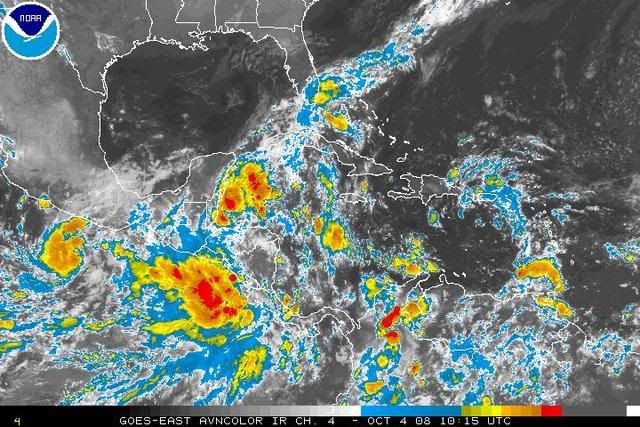
ABNT20 KNHC 041145
TWOAT
TROPICAL WEATHER OUTLOOK
NWS TPC/NATIONAL HURRICANE CENTER MIAMI FL
800 AM EDT SAT OCT 04 2008
FOR THE NORTH ATLANTIC...CARIBBEAN SEA AND THE GULF OF MEXICO...
DISORGANIZED SHOWERS AND THUNDERSTORMS OVER THE NORTHWESTERN
CARIBBEAN SEA ARE ASSOCIATED WITH A BROAD AREA OF LOW PRESSURE.
THIS ACTIVITY IS EXPECTED TO DRIFT WESTWARD OVER THE YUCATAN
PENINSULA AND DEVELOPMENT IS NOT ANTICIPATED.
ELSEWHERE...TROPICAL CYCLONE FORMATION IS NOT EXPECTED DURING THE
NEXT 48 HOURS.
$$
FORECASTER AVILA
0 likes
-
Ed Mahmoud
Re: Area Of Disturbed Weather In NW Caribbean.
caneman wrote:wOW! I woulddn't be so sure of that Ed. What a blow up of convection overnight. Can it maintain? That is the question.
Looks like the East Pac system has a head start...
0 likes
-
Ed Mahmoud
Re: Area Of Disturbed Weather In NW Caribbean.
I'd say the Pacific system South of this and East of 15-E is probably already darn close to being a depression. Looks like the future 16-E will move parallel to this as this crosses the Yucatan, at least in the short term.
In my unofficial and amateur opinion, 5% of less chance of this area becoming a TC.
However, as in past MJO pulses, the EastPac up-ticked first, and this area certainly showed a lot of convection, so I'd say the system passing the Lesser Antilles just North of Venezuela has a shot in a few days.
In my unofficial and amateur opinion, 5% of less chance of this area becoming a TC.
However, as in past MJO pulses, the EastPac up-ticked first, and this area certainly showed a lot of convection, so I'd say the system passing the Lesser Antilles just North of Venezuela has a shot in a few days.
0 likes
Re: Area Of Disturbed Weather In NW Caribbean.
I wanted to say yesterday's nakedness was another giant 2008 d-min but didn't want to look stupid if it didn't pan-out. It did. This was another giant 2008 d-min with this wave.
Surprised that the direction is west which should give this disturbance problems in forming because of Yucatan. The MJO positive phase they were talking about is really showing up. I think it will carry this one whether it tracks over Yucatan or not.
Get ready Gulf.
Surprised that the direction is west which should give this disturbance problems in forming because of Yucatan. The MJO positive phase they were talking about is really showing up. I think it will carry this one whether it tracks over Yucatan or not.
Get ready Gulf.
0 likes
-
cycloneye
- Admin
- Posts: 149276
- Age: 69
- Joined: Thu Oct 10, 2002 10:54 am
- Location: San Juan, Puerto Rico
Re: Area Of Disturbed Weather In NW Caribbean.
Ed Mahmoud wrote:I'd say the Pacific system South of this and East of 15-E is probably already darn close to being a depression. Looks like the future 16-E will move parallel to this as this crosses the Yucatan, at least in the short term.
In my unofficial and amateur opinion, 5% of less chance of this area becoming a TC.
However, as in past MJO pulses, the EastPac up-ticked first, and this area certainly showed a lot of convection, so I'd say the system passing the Lesser Antilles just North of Venezuela has a shot in a few days.
Is now invest 92E.
0 likes
Re: Area Of Disturbed Weather In NW Caribbean.
Early fall conditions and warm water weakned the front which allowed our wave to move west. I think some in here would agree it should turn N.
0 likes
-
Ed Mahmoud
Re: Area Of Disturbed Weather In NW Caribbean.
cycloneye wrote:Ed Mahmoud wrote:I'd say the Pacific system South of this and East of 15-E is probably already darn close to being a depression. Looks like the future 16-E will move parallel to this as this crosses the Yucatan, at least in the short term.
In my unofficial and amateur opinion, 5% of less chance of this area becoming a TC.
However, as in past MJO pulses, the EastPac up-ticked first, and this area certainly showed a lot of convection, so I'd say the system passing the Lesser Antilles just North of Venezuela has a shot in a few days.
Is now invest 92E.
Double post from 92E thread
About time. I noticed this while thinking about the Caribbean system, and I think this has got a big start on the Caribbean system, and probably keeps it from developing.
For that matter, although a little behind, based on size, this may limit how much 15-E can strengthen.
0 likes
-
Ed Mahmoud
Re: Area Of Disturbed Weather In NW Caribbean.
Sanibel wrote:Early fall conditions and warm water weakned the front which allowed our wave to move west. I think some in here would agree it should turn N.
Only chance it has is to gain some separation from 92E.
0 likes
Re: Area Of Disturbed Weather In NW Caribbean.
I might be wrong but 92E could be a reflection of our Caribbean wave's energy. It could get sucked N behind our wave and transfer its energy to it.
0 likes
-
Ed Mahmoud
Re: Area Of Disturbed Weather In NW Caribbean.
Sanibel wrote:I might be wrong but 92E could be a reflection of our Caribbean wave's energy. It could get sucked N behind our wave and transfer its energy to it.
92E has at least a mid level circulation. I'd say it is time to watch this wave or my dark horse sub-tropical development from an upper low system.
0 likes
Who is online
Users browsing this forum: Blown Away, dexterlabio and 205 guests