Link: http://www.nrlmry.navy.mil/tc-bin/tc_ho ... &TYPE=ssmi
And they continue to pop!!
BEGIN
NHC
invest_al992008.invest
FSTDA
R
U
040
010
0000
200810131331
NONE
NOTIFY=ATRP
END
INVEST, AL, L, , , , , 99, 2008, DB, O, 2008101312, 9999999999, , , , , , METWATCH, , AL992008
AL, 99, 2008101212, , BEST, 0, 104N, 824W, 20, 1009, DB, 0, , 0, 0, 0, 0,
AL, 99, 2008101218, , BEST, 0, 112N, 823W, 20, 1009, DB, 0, , 0, 0, 0, 0,
AL, 99, 2008101300, , BEST, 0, 120N, 822W, 20, 1008, DB, 0, , 0, 0, 0, 0,
AL, 99, 2008101306, , BEST, 0, 127N, 822W, 20, 1007, DB, 0, , 0, 0, 0, 0,
AL, 99, 2008101312, , BEST, 0, 134N, 821W, 25, 1006, DB, 34, NEQ, 0, 0, 0, 0, 1009, 140, 0, 0, 0, L, 0, , 0, 0, INVEST, M,
ATL SIXTEEN: Tropical Depression - Discussion
Moderator: S2k Moderators


Re: ATL: INVEST 99L - Discussion
0 likes

-
tolakram
- Admin

- Posts: 20189
- Age: 62
- Joined: Sun Aug 27, 2006 8:23 pm
- Location: Florence, KY (name is Mark)
Re: ATL: INVEST 99L - Discussion
I think the quickscat pass might be the reason it got tagged.

0 likes
-
HURAKAN

- Professional-Met

- Posts: 46084
- Age: 39
- Joined: Thu May 20, 2004 4:34 pm
- Location: Key West, FL
- Contact:
837
WONT41 KNHC 131516
DSAAT
SPECIAL TROPICAL DISTURBANCE STATEMENT
NWS TPC/NATIONAL HURRICANE CENTER MIAMI FL
1130 AM EDT MON OCT 13 2008
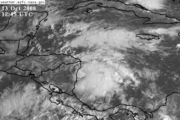
A BROAD AREA OF LOW PRESSURE HAS FORMED IN THE SOUTHWESTERN
CARIBBEAN SEA ABOUT 100 MILES EAST-SOUTHEAST OF PUERTO CABEZAS
NICARAGUA...AND IS ACCOMPANIED BY A LARGE AREA OF DISTURBED
WEATHER. CONDITIONS APPEAR FAVORABLE FOR ADDITIONAL DEVELOPMENT...
AND THE SYSTEM COULD BECOME A TROPICAL DEPRESSION DURING THE NEXT
COUPLE OF DAYS AS IT MOVES SLOWLY NORTH OR NORTHWESTWARD. AN AIR
FORCE RESERVE HURRICANE HUNTER AIRCRAFT IS SCHEDULED TO INVESTIGATE
THE SYSTEM ON TUESDAY...IF NECESSARY. INTERESTS IN NICARAGUA...
HONDURAS...AND THE NORTHWESTERN CARIBBEAN SEA SHOULD MONITOR THE
PROGRESS OF THIS DISTURBANCE.
$$
FORECASTER BROWN/AVILA
WONT41 KNHC 131516
DSAAT
SPECIAL TROPICAL DISTURBANCE STATEMENT
NWS TPC/NATIONAL HURRICANE CENTER MIAMI FL
1130 AM EDT MON OCT 13 2008
A BROAD AREA OF LOW PRESSURE HAS FORMED IN THE SOUTHWESTERN
CARIBBEAN SEA ABOUT 100 MILES EAST-SOUTHEAST OF PUERTO CABEZAS
NICARAGUA...AND IS ACCOMPANIED BY A LARGE AREA OF DISTURBED
WEATHER. CONDITIONS APPEAR FAVORABLE FOR ADDITIONAL DEVELOPMENT...
AND THE SYSTEM COULD BECOME A TROPICAL DEPRESSION DURING THE NEXT
COUPLE OF DAYS AS IT MOVES SLOWLY NORTH OR NORTHWESTWARD. AN AIR
FORCE RESERVE HURRICANE HUNTER AIRCRAFT IS SCHEDULED TO INVESTIGATE
THE SYSTEM ON TUESDAY...IF NECESSARY. INTERESTS IN NICARAGUA...
HONDURAS...AND THE NORTHWESTERN CARIBBEAN SEA SHOULD MONITOR THE
PROGRESS OF THIS DISTURBANCE.
$$
FORECASTER BROWN/AVILA
0 likes

-
HURAKAN
- Professional-Met
- Posts: 46084
- Age: 39
- Joined: Thu May 20, 2004 4:34 pm
- Location: Key West, FL
- Contact:
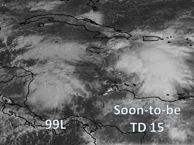
Floater 99L:
http://www.ssd.noaa.gov/PS/TROP/float3.html
It's wrongly placed over TD 15 but the error should be fixed shorty.
Update: Now changed back to "Not Active."
http://www.ssd.noaa.gov/PS/TROP/float3.html
It's wrongly placed over TD 15 but the error should be fixed shorty.
Update: Now changed back to "Not Active."
0 likes

Re: ATL: INVEST 99L - Discussion - STDS
BAMs do a Marco and scoot 99L under the cut-off LOW steering feature affecting 98L and towards Central America. I'm not sure about Florida. Our infamous CLP model is right to Sanibel on a doomsday track over prime SST's. I put it and NAM in the same class.
I'm absolutely awed and amazed how the models pulled this one out of thin air and there it is materializing.
MJO juice!
I'm absolutely awed and amazed how the models pulled this one out of thin air and there it is materializing.
MJO juice!
0 likes
-
Tampa Bay Hurricane

- Category 5

- Posts: 5597
- Age: 38
- Joined: Fri Jul 22, 2005 7:54 pm
- Location: St. Petersburg, FL
I have a question. I am worried. Is 99L going to get
pulled north and a cold front is supposed to
arrive in 5 days near Florida...could this be a long
range threat to Florida? It is in a similar location
to Category 5 Wilma and the 1921 Category 3 Major that devastated Tampa Bay, and around where Hurricane Mitch
Category 5 formed.
Obviously Central America has to watch this the closest,
but I am voicing my concern because of living in Florida
and climatology of October storms hitting Florida and the Cold
Front moving into the Gulf in 5 days near Florida...
0 likes
Who is online
Users browsing this forum: No registered users and 26 guests