ATL OMAR: Remnant Low - Discussion
Moderator: S2k Moderators


-
Category 5

- Category 5

- Posts: 10074
- Age: 35
- Joined: Sun Feb 11, 2007 10:00 pm
- Location: New Brunswick, NJ
- Contact:
Re: Re:
Ed Mahmoud wrote:HURAKAN wrote:
Omar is not stopping.
Hmmmm, prawns....
Are you drinking again?
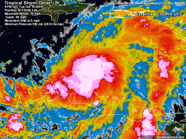
Nasty nasty convection on this storm. In fact, more impressive then Wilma by quite a bit.
Last edited by Category 5 on Tue Oct 14, 2008 10:26 pm, edited 1 time in total.
0 likes
-
Ed Mahmoud
Re: Re:
Category 5 wrote:Ed Mahmoud wrote:HURAKAN wrote:Omar is not stopping.
Hmmmm, prawns....
Are you drinking again?
Nasty nasty convection on this storm.
If this were Saturday night, maybe, but I get up in about 7 hours. I'm hoping for an invite to a co-worker's house with big screen/hi-def for the Missouri game, so I shan't be on S2K much that night, when I am drinking.
With all the sub -80ºC convection still firing, I would not be surprised to see this almost a major when aircraft is in it in a few hours.
0 likes
Re: ATL OMAR: Hurricane - Discussion
BVIgal:
Models miss you to east but get ready. St Croix should get an experience from this if it does what it looks like it is doing. But slight track shift left could bring you significant cyclone.
Models miss you to east but get ready. St Croix should get an experience from this if it does what it looks like it is doing. But slight track shift left could bring you significant cyclone.
0 likes
-
Ed Mahmoud
Re: ATL OMAR: Hurricane - Discussion
Based on modelling and impressive satellite appearance, Cat 3 during its closest approach to Puerto Rico and then the VIs/St Martin doesn't seem impossible. In my amateur and unofficial opinion. After about 48 hours, I'd think lower heat content and increasing shear will stop and then reverse intensification.
Unofficially.

ETA: Official NHC probability table doesn't see much chance for a Cat 5

Unofficially.
ETA: Official NHC probability table doesn't see much chance for a Cat 5
0 likes
-
bvigal

- S2K Supporter

- Posts: 2276
- Joined: Sun Jul 24, 2005 8:49 am
- Location: British Virgin Islands
- Contact:
Re: ATL OMAR: Hurricane - Discussion
Sanibel wrote:BVIgal:
Models miss you to east but get ready. St Croix should get an experience from this if it does what it looks like it is doing. But slight track shift left could bring you significant cyclone.
That sounds great!!! What models?
0 likes


-
bvigal
- S2K Supporter
- Posts: 2276
- Joined: Sun Jul 24, 2005 8:49 am
- Location: British Virgin Islands
- Contact:
Re:
msbee wrote:I have a question. On its current track, it is supposed to pass maybe 55 -60 miles from us.
I know it can wobble and maybe come closer.
but on the current track, I am wondering what St. Maarten can expect in terms of wind.
How far out from the center do hurricane force winds extend?
Barbara
Hi Barbara!
Can't sleep either, huh?
Try this link, http://www.nlmoc.navy.mil/cgi-bin/viewtext.pl?File=/center/Tropical/wtnt02 to get the specific quadrant information for each forecast point.
PS - on my Google Earth with 11pm forecast points, track path nearest point to west end of St. Martin is 46 nautical miles.
0 likes
Re: ATL OMAR: Hurricane - Discussion
good morning
it is morning isn't it?
yea, I can't sleep either
thanks for the link
I'll check it out
46 NM is too darn close.
no one ere has boarded up or anything. what a crazy morning ti's gonna be
it is morning isn't it?
yea, I can't sleep either
thanks for the link
I'll check it out
46 NM is too darn close.
no one ere has boarded up or anything. what a crazy morning ti's gonna be
0 likes
Re: ATL OMAR: Hurricane - Discussion
OK, so let's see. so if it passes 46 NM from us, then we can expect to see somewhere between 50-64KT winds..according to that link.
0 likes
-
bvigal
- S2K Supporter
- Posts: 2276
- Joined: Sun Jul 24, 2005 8:49 am
- Location: British Virgin Islands
- Contact:
Re: ATL OMAR: Hurricane - Discussion
msbee wrote:OK, so let's see. so if it passes 46 NM from us, then we can expect to see somewhere between 50-64KT winds..according to that link.
36 HRS, VALID AT:
161200Z --- 19.1N 63.3W
MAX SUSTAINED WINDS - 090 KT, GUSTS 110 KT
RADIUS OF 064 KT WINDS - 030 NM NORTHEAST QUADRANT
030 NM SOUTHEAST QUADRANT
020 NM SOUTHWEST QUADRANT
020 NM NORTHWEST QUADRANT
RADIUS OF 050 KT WINDS - 050 NM NORTHEAST QUADRANT
060 NM SOUTHEAST QUADRANT
040 NM SOUTHWEST QUADRANT
030 NM NORTHWEST QUADRANT
Yes. The way I read it, closer to 50kt. Those are maximums.
However, I think it's much more important that you are under a hurricane warning. That means the experts say that you may experience hurricane conditions. These plotted points and quadrants are a guideline. Outer bands have been known to produce brief periods of much stronger winds than quandrant forecasts might indicate for a given point. From a warning/preparedness standpoint, that is the safest way to approach it.
Last edited by bvigal on Wed Oct 15, 2008 2:00 am, edited 1 time in total.
0 likes

Man alive, Omar looks to want to renew it's title from the Wpac for the Atlantic! From my perspective, it looks like a classic October monster in the making, very large hurricane that could just explode. It would not shock me to find a major hurricane tomorrow afternoon. Early this morning, I just had a feeling by the way it was rotating and that deep convection that RI was certainly in the cards for Omar. The flood threat will be very high for the islands since they have been soaked from Kyle and other systems.
I do have to post this though, it does remind me of Wilma's early evolution.
I do have to post this though, it does remind me of Wilma's early evolution.
0 likes
-
bvigal
- S2K Supporter
- Posts: 2276
- Joined: Sun Jul 24, 2005 8:49 am
- Location: British Virgin Islands
- Contact:
Re: ATL OMAR: Hurricane - Discussion
Really anxious to see the first sat pics in 3 hrs. Here's one now!
[URL=http://imageshack.us] [/
[/
[URL=http://imageshack.us]
[/
0 likes
-
TheEuropean

- Professional-Met

- Posts: 1797
- Age: 60
- Joined: Tue Sep 20, 2005 3:17 pm
- Location: Voerde, Germany
- Contact:

Re: ATL OMAR: Hurricane - Discussion
bvigal wrote:Really anxious to see the first sat pics in 3 hrs. Here's one now!
[URL=http://imageshack.us]
Still awake ladies? I fell out sometime before 11, glad I did because I'm sure awake now. It is dead calm here. What are your conditions?
Since no one seems to be awake I'll edit this to add...does anyone expect any increase in speed? The timing of *landfall* (used loosely, we're sort of ducks on pond here) on this seems to be getting slower and slower (stronger and stronger)?
0 likes


Who is online
Users browsing this forum: No registered users and 18 guests