Big Baby does not have enough, juicy abundant convection....
ATL OMAR: Remnant Low - Discussion
Moderator: S2k Moderators


Re: ATL OMAR: Hurricane - Discussion
caribepr wrote:bvigal wrote:Really anxious to see the first sat pics in 3 hrs. Here's one now!
[URL=http://imageshack.us][/
Still awake ladies? I fell out sometime before 11, glad I did because I'm sure awake now. It is dead calm here. What are your conditions?
Since no one seems to be awake I'll edit this to add...does anyone expect any increase in speed? The timing of *landfall* (used loosely, we're sort of ducks on pond here) on this seems to be getting slower and slower (stronger and stronger)?
MJ....went back to bed at 3..up at 6.
restless night.
all gray and cloudy here. still trying to decide whether or not to board up.
where is bvigirl?? sleeping in late this morning? LOL
0 likes

-
apocalypt-flyer
- Category 1

- Posts: 468
- Joined: Sat Aug 27, 2005 11:51 am
Re: ATL OMAR: Hurricane - Discussion
Oh dear, Omar has been ramping it up at an immense rate over the past hours. It would NOT shock me to see a major before this one heads out to the open Atlantic. Potentially very dangerous.
0 likes
Re: ATL OMAR: Hurricane - Discussion
msbee wrote:
MJ....went back to bed at 3..up at 6.
restless night.
all gray and cloudy here. still trying to decide whether or not to board up.
where is bvigirl?? sleeping in late this morning? LOL
I hope she's sleeping! Get it while you can... Everyone I know who was on the board up/not board up fence have decided to board up this morning (too much strengthening too fast, better over kill than under). All the helpers were waiting for was the go word, so I imagine they are already at it now.
Last edited by caribepr on Wed Oct 15, 2008 6:50 am, edited 1 time in total.
0 likes
-
bvigal

- S2K Supporter

- Posts: 2276
- Joined: Sun Jul 24, 2005 8:49 am
- Location: British Virgin Islands
- Contact:
Re: ATL OMAR: Hurricane - Discussion
I'm here, been pm'ing MJ. I finally went to bed about 3:30, up at 5. BOARD UP, then you can drink!msbee wrote: MJ....went back to bed at 3..up at 6.
restless night.
all gray and cloudy here. still trying to decide whether or not to board up.
where is bvigirl?? sleeping in late this morning? LOL
Last edited by bvigal on Wed Oct 15, 2008 6:50 am, edited 1 time in total.
0 likes

Re: ATL OMAR: Hurricane - Discussion
bvigal wrote:I'm here, been pm'ing MJ. I finally went to bed about 3:30, up at 5. BOARD UP, then you can drink!msbee wrote: MJ....went back to bed at 3..up at 6.
restless night.
all gray and cloudy here. still trying to decide whether or not to board up.
where is bvigirl?? sleeping in late this morning? LOL
ROFL!!! (I hate these acronyms, but it's true in this case!)
0 likes
-
HURAKAN

- Professional-Met

- Posts: 46084
- Age: 39
- Joined: Thu May 20, 2004 4:34 pm
- Location: Key West, FL
- Contact:
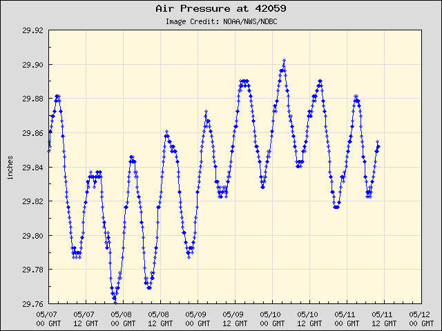
Buoy 42059 is right in the path of Omar. Link: http://www.ndbc.noaa.gov/station_page.php?station=42059

0 likes
-
Tampa Bay Hurricane

- Category 5

- Posts: 5597
- Age: 38
- Joined: Fri Jul 22, 2005 7:54 pm
- Location: St. Petersburg, FL
-
HURAKAN
- Professional-Met
- Posts: 46084
- Age: 39
- Joined: Thu May 20, 2004 4:34 pm
- Location: Key West, FL
- Contact:
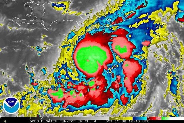
Link to radar image: http://rammb.cira.colostate.edu/ramsdis ... ar_floater
Link to loop: http://rammb.cira.colostate.edu/ramsdis ... ar_floater

Omar's eye.
Link to loop: http://rammb.cira.colostate.edu/ramsdis ... ar_floater
Omar's eye.
0 likes
Re: ATL OMAR: Hurricane - Discussion
bvigal wrote:I'm here, been pm'ing MJ. I finally went to bed about 3:30, up at 5. BOARD UP, then you can drink!msbee wrote: MJ....went back to bed at 3..up at 6.
restless night.
all gray and cloudy here. still trying to decide whether or not to board up.
where is bvigirl?? sleeping in late this morning? LOL
oh, I love that advice LOL ROFL all of the above!
0 likes
-
alan1961

- Category 2

- Posts: 771
- Joined: Mon Mar 20, 2006 11:58 am
- Location: Derby, Derbyshire, England
- Contact:
Re: ATL OMAR: Hurricane - Discussion
Here are some live streaming webcams for Omar.
http://www.beto.net/betotv.htm
http://sugar-cam.viewnetcam.com:50000/C ... Language=0
http://208.0.229.84/CgiStart?page=Singl ... Language=0
http://www.beto.net/betotv.htm
http://sugar-cam.viewnetcam.com:50000/C ... Language=0
http://208.0.229.84/CgiStart?page=Singl ... Language=0
0 likes
-
cycloneye

- Admin

- Posts: 149276
- Age: 69
- Joined: Thu Oct 10, 2002 10:54 am
- Location: San Juan, Puerto Rico
Re: ATL OMAR: Hurricane - Discussion
15/1115 UTC 15.0N 67.4W T4.5/4.5 OMAR -- Atlantic Ocean
0 likes
-
Gustywind

- Category 5
- Posts: 12334
- Joined: Mon Sep 03, 2007 7:29 am
- Location: Baie-Mahault, GUADELOUPE
000
AXNT20 KNHC 151159
TWDAT
TROPICAL WEATHER DISCUSSION
NWS TPC/NATIONAL HURRICANE CENTER MIAMI FL
805 AM EDT WED OCT 15 2008
TROPICAL WEATHER DISCUSSION FOR NORTH AMERICA...CENTRAL
AMERICA...GULF OF MEXICO...CARIBBEAN SEA...NORTHERN SECTIONS
OF SOUTH AMERICA...AND ATLANTIC OCEAN TO THE AFRICAN COAST
FROM THE EQUATOR TO 32N. THE FOLLOWING INFORMATION IS
BASED ON SATELLITE IMAGERY...METEOROLOGICAL ANALYSIS...
WEATHER OBSERVATIONS...AND RADAR.
BASED ON 0600 UTC SURFACE ANALYSIS AND SATELLITE IMAGERY
THROUGH 1015 UTC.
...SPECIAL FEATURES...
THE CENTER OF HURRICANE OMAR AT 15/1200 UTC IS NEAR 14.9N 67.5W
OR ABOUT 230 NM...425 KM...SOUTHWEST OF ST. CROIX AND ABOUT
230 MILES...425 KM...SOUTH-SOUTHWEST OF SAN JUAN PUERTO RICO.
MOVING NORTHEAST AT 6 KT. AND THIS MOTION IS EXPECTED TO
CONTINUE WITH A GRADUAL INCREASE IN FORWARD SPEED OVER THE NEXT
DAY OR TWO. ON THE FORECAST TRACK...OMAR WOULD MOVE THROUGH THE
NORTHERN LEEWARD ISLANDS LATE TONIGHT AND EARLY THURSDAY.
THE ESTIMATED MINIMUM CENTRAL PRESSURE IS 984 MB. THE MAXIMUM
SUSTAINED WIND SPEED IS 70 KT WITH HIGHER GUSTS. PLEASE READ THE
LATEST NHC PUBLIC ADVISORY UNDER AWIPS/WMO HEADERS
MIATCPAT5/WTNT35 KNHC AND THE FULL FORECAST/ADVISORY UNDER
AWIPS/WMO HEADERS MIATCMAT5/WTNT25 KNHC FOR MORE DETAILS.
NUMEROUS STRONG SHOWERS AND THUNDERSTORMS FROM 12N AT THE
ISLANDS OF ARUBA/BONAIRE/ CURACAO TO 16.5N BETWEEN 64.5W AND
70.5W.
0 likes
Who is online
Users browsing this forum: No registered users and 10 guests