ATL OMAR: Remnant Low - Discussion

Moderator: S2k Moderators

Message
Author
User avatar
Gustywind
Category 5
Category 5
Posts: 12334
Joined: Mon Sep 03, 2007 7:29 am
Location: Baie-Mahault, GUADELOUPE

Re: ATL OMAR: Hurricane - Discussion

#481 Postby Gustywind » Wed Oct 15, 2008 2:24 pm

wxman57 wrote:
Gustywind wrote:
cycloneye wrote:Agree 57 with your assesment about the track.Good for me,but bad for our friends eastward.

Absolutely , not good news for Msbee and the others Leewards
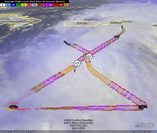
REPEATING THE 200 PM AST POSITION...15.3 N...66.6 W. MOVEMENT
TOWARD...EAST-NORTHEAST NEAR 13 MPH.
MAXIMUM SUSTAINED WINDS...85
MPH. MINIMUM CENTRAL PRESSURE...978 MB.

THE NEXT ADVISORY WILL BE ISSUED BY THE NATIONAL HURRICANE CENTER
AT 500 PM AST.

$$
FORECASTER STEWART

Hope it's just a wobble...and no more...


Actually, if it passes just east of St. Croix then hurricane force sustained winds may miss all the islands.

Yeah i will be GLAD for all islanderswxman57, but but there's much time and many incertitudes as usual ,the final path is always a long outcome and it could be nervously difficult for all who are in alerts to wait like that , long night ahead all the Leewards Islands we have "just " :cheesy: :spam: to WAIT and SEE!
0 likes   

User avatar
HURAKAN
Professional-Met
Professional-Met
Posts: 46086
Age: 38
Joined: Thu May 20, 2004 4:34 pm
Location: Key West, FL
Contact:

#482 Postby HURAKAN » Wed Oct 15, 2008 2:26 pm

191900 1528N 06615W 6967 02988 9848 +108 +070 262088 089 074 000 00

So far 89 knots at FL, SFMR 74 knots.
0 likes   

User avatar
MGC
S2K Supporter
S2K Supporter
Posts: 5899
Joined: Sun Mar 23, 2003 9:05 pm
Location: Pass Christian MS, or what is left.

Re: ATL OMAR: Hurricane - Discussion

#483 Postby MGC » Wed Oct 15, 2008 2:27 pm

Trough is pushing south into the north Caribbean...this will push Omar to the east of St Croix. Omar should continue to slowly intensify as the hurricane approaches the islands. Hurricane force winds will likely remain over water as the hurricane does not make landfall but passes between the islands. St. Martin area will likely experience the strongest winds.....MGC

Of couse the above is the opinion of MGC and not an official forecast.
0 likes   

User avatar
msbee
S2K Supporter
S2K Supporter
Posts: 3027
Joined: Wed Jun 11, 2003 10:11 am
Location: St. Maarten

Re: ATL OMAR: Hurricane - Discussion

#484 Postby msbee » Wed Oct 15, 2008 2:28 pm

keep posting updates please, wxman57
very helpful analysis and images.
Barbara
0 likes   

User avatar
wxman57
Moderator-Pro Met
Moderator-Pro Met
Posts: 22977
Age: 67
Joined: Sat Jun 21, 2003 8:06 pm
Location: Houston, TX (southwest)

Re:

#485 Postby wxman57 » Wed Oct 15, 2008 2:33 pm

HURAKAN wrote:191900 1528N 06615W 6967 02988 9848 +108 +070 262088 089 074 000 00

So far 89 knots at FL, SFMR 74 knots.


The only change from earlier is that it could really have a small area of 85 mph wind now. Probably won't reach Cat 2 before passing the islands. Most areas will see TS winds as it passes. Hurricane force winds are over such a small area that they probably won't be recorded. Our track takes the center directly over St. Croix now, by the way. But I still have a feeling it'll pass just east of St. Croix.
0 likes   

CrazyC83
Professional-Met
Professional-Met
Posts: 34002
Joined: Tue Mar 07, 2006 11:57 pm
Location: Deep South, for the first time!

#486 Postby CrazyC83 » Wed Oct 15, 2008 2:34 pm

Current data supports 80 kt for an intensity...FL 89, SFMR 81. Pressure down to 969, although the VDM will confirm what it really is.
0 likes   

User avatar
Thunder44
Category 5
Category 5
Posts: 5922
Age: 44
Joined: Mon Jun 09, 2003 7:53 pm
Location: New York City

Re:

#487 Postby Thunder44 » Wed Oct 15, 2008 2:37 pm

CrazyC83 wrote:Current data supports 80 kt for an intensity...FL 89, SFMR 81. Pressure down to 969, although the VDM will confirm what it really is.


That report was in the NW Quad. SFMR supports hurricane force winds in that quad now, but FL winds don't yet.
0 likes   

User avatar
HURAKAN
Professional-Met
Professional-Met
Posts: 46086
Age: 38
Joined: Thu May 20, 2004 4:34 pm
Location: Key West, FL
Contact:

#488 Postby HURAKAN » Wed Oct 15, 2008 2:38 pm

Image
0 likes   

User avatar
wxman57
Moderator-Pro Met
Moderator-Pro Met
Posts: 22977
Age: 67
Joined: Sat Jun 21, 2003 8:06 pm
Location: Houston, TX (southwest)

Re:

#489 Postby wxman57 » Wed Oct 15, 2008 2:41 pm

CrazyC83 wrote:Current data supports 80 kt for an intensity...FL 89, SFMR 81. Pressure down to 969, although the VDM will confirm what it really is.


37 kts FL winds and 81 kts SFMR??? Seems a bit suspicious.
0 likes   

User avatar
HURAKAN
Professional-Met
Professional-Met
Posts: 46086
Age: 38
Joined: Thu May 20, 2004 4:34 pm
Location: Key West, FL
Contact:

#490 Postby HURAKAN » Wed Oct 15, 2008 2:48 pm

Image

Omar moving fast which is always good news.
0 likes   

User avatar
HURAKAN
Professional-Met
Professional-Met
Posts: 46086
Age: 38
Joined: Thu May 20, 2004 4:34 pm
Location: Key West, FL
Contact:

#491 Postby HURAKAN » Wed Oct 15, 2008 2:54 pm

RECON reporting that Omar has been shopping for a new eyewall and it's being placed around the center.
0 likes   

Sanibel
Category 5
Category 5
Posts: 10375
Joined: Mon Aug 30, 2004 11:06 pm
Location: Offshore SW Florida

Re: ATL OMAR: Hurricane - Discussion

#492 Postby Sanibel » Wed Oct 15, 2008 3:21 pm

We could be having dry air intrusion of the eye. Black IR dried up.

Track looks like it has returned to previous east of St Croix path.

978-973 (if accurate) is Rapid Intensification.
0 likes   

User avatar
HURAKAN
Professional-Met
Professional-Met
Posts: 46086
Age: 38
Joined: Thu May 20, 2004 4:34 pm
Location: Key West, FL
Contact:

#493 Postby HURAKAN » Wed Oct 15, 2008 3:47 pm

Image

Closer.
0 likes   

User avatar
HURAKAN
Professional-Met
Professional-Met
Posts: 46086
Age: 38
Joined: Thu May 20, 2004 4:34 pm
Location: Key West, FL
Contact:

#494 Postby HURAKAN » Wed Oct 15, 2008 3:47 pm

Repeating the 500 PM AST position...15.9 N...66.1 W. Movement
toward...northeast near 15 mph. Maximum sustained winds...90 mph.
Minimum central pressure...973 mb.

90 mph

Image
0 likes   

User avatar
msbee
S2K Supporter
S2K Supporter
Posts: 3027
Joined: Wed Jun 11, 2003 10:11 am
Location: St. Maarten

Re: ATL OMAR: Hurricane - Discussion

#495 Postby msbee » Wed Oct 15, 2008 3:56 pm

00
WTNT45 KNHC 152044
TCDAT5
HURRICANE OMAR DISCUSSION NUMBER 10
NWS TPC/NATIONAL HURRICANE CENTER MIAMI FL AL152008
500 PM EDT WED OCT 15 2008

TWO RECENT PASSES THROUGH OMAR'S EYE INDICATE THE CENTRAL PRESSURE
DECREASED BY AT LEAST 4 MB...DOWN TO 973 MB. THE AIR FORCE RESERVE
HURRICANE HUNTER AIRCRAFT ALSO MEASURED A PEAK 700 MB FLIGHT-LEVEL
WIND OF 89 KT IN THE SOUTHEAST QUADRANT...WHICH EQUATES TO ABOUT AN
80-KT SURFACE WIND...DESPITE THE HIGHEST SFMR SURFACE MEASURED
HAVING ONLY BEEN 74 KT. HOWEVER...THE RECON AIRCRAFT AND THE
CONVECTION HAVE BEEN PLAYING A GAME OF CAT-AND-MOUSE...AND I DO NOT
BELIEVE THAT THE AIRCRAFT HAS BEEN SAMPLING THE STRONGEST WINDS IN
THE STRONGEST CONVECTION. THE ADVISORY INTENSITY HAS BEEN INCREASED
TO 80 KT...WHICH COULD BE A LITTLE LOW GIVEN THAT THE PRESSURE-WIND
RELATIONSHIP FOR 973 MB CORRESPONDS TO ABOUT 85 KT.

THE INITIAL MOTION ESTIMATE IS 050/013. AFTER AN EARLIER JOG TO THE
EAST-NORTHEAST...IT APPEARS THAT OMAR HAS RESUMED ITS BASE COURSE
BACK TOWARD THE NORTHEAST. THERE REMAINS NO SIGNIFICANT CHANGE TO
THE PREVIOUS TRACK FORECAST OR PHILOSOPHY AS ALL OF THE TRACK
MODELS REMAIN TIGHTLY CLUSTERED ABOUT A NORTHEASTWARD MOTION
THROUGH THE NORTHERN LEEWARD ISLANDS AND THE VIRGIN ISLANDS IN
12-18 HOURS HOURS. AFTER THAT...OMAR IS FORECAST TO ACCELERATE AS
IT GETS DRAWN RAPIDLY NORTHEASTWARD IN SOUTHWESTERLY STEERING FLOW
ON THE EAST SIDE OF A LARGE MID-TROPOSPHERIC TROUGH THAT IS
FORECAST TO MOVE OFF THE U.S. EAST COAST AND INTO THE WESTERN AND
CENTRAL ATLANTIC BY DAY 3. DURING DAYS 4-5...OMAR IS EXPECTED TO
ACCELERATE THE EAST-NORTHEAST OR EASTWARD AT FORWARD SPEEDS IN
EXCESS OF 35 KT AND BECOME EXTRATROPICAL OVER THE MUCH COOLER
WATERS OF THE NORTH ATLANTIC. THE OFFICIAL FORECAST TRACK IS
SLIGHTLY TO THE RIGHT OF PREVIOUS TRACK...AND REMAINS SLOWER THAN
THE NHC MODEL CONSENSUS...WHICH HAS HAD A NOTICEABLE FAST FORWARD
SPEED BIAS.

STRONG CONVECTIVE BURSTS HAVE CONTINUED TO DEVELOP IN THE EYEWALL
AND RADAR DATA FROM SAN JUAN HAS INDICATED OCCASIONAL DISTINCT
MESOVORTICES ROTATING AROUND THE INNER PORTION OF THE EYEWALL. THIS
FAVORABLE SMALL-SCALE INTENSIFICATION SHOULD PERSISTS FOR ANOTHER
12 HOURS OR SO...WHICH MEANS THAT OMAR HAS A GOOD CHANCE OF
REACHING AT LEAST CATEGORY 2 INTENSITY BEFORE IT MOVES THROUGH THE
NORTHERN LEEWARD ISLANDS LATER TONIGHT AND THURSDAY MORNING. THE
GFDL MODEL WAS MUCH MORE BULLISH WITH OMAR ON THE 12Z MODEL RUN AND
BRINGS THE HURRICANE UP TO 109 KT BY 18-24 HOURS. THAT MUCH
INTENSIFICATION IS LIKELY OVERDONE GIVEN SATELLITE INDICATIONS OF A
RAPIDLY SHRINKING CDO FEATURE...PLUS THE INTRUSION OF DRY MID-LEVEL
INTO THE NORTHWEST QUADRANT OF THE CYCLONE. HOWEVER...SINCE OMAR IS
EXPECTED TO REMAIN IN A RELATIVELY LOW SHEAR ENVIRONMENT AND OVER
29C SSTS...ADDITIONAL STRENGTHENING TO 90 KT SEEMS VERY PLAUSIBLE
...AND WOULD MOST LIKELY OCCUR LATER TONIGHT DURING THE USUAL
NOCTURNAL CONVECTIVE MAXIMUM PERIOD. ALSO...INTERESTS IN THE
LEEWARD ISLANDS ARE REMINDED THAT STRONGER WINDS...POSSIBLY ONE
CATEGORY HIGHER...CAN BE EXPECTED OVER HIGHER TERRAIN...ESPECIALLY
ABOVE 500 FT ELEVATION.

FORECAST POSITIONS AND MAX WINDS

INITIAL 15/2100Z 15.9N 66.1W 80 KT
12HR VT 16/0600Z 17.6N 64.8W 85 KT...NRN LEEWARD ISLANDS
24HR VT 16/1800Z 20.4N 62.9W 90 KT
36HR VT 17/0600Z 23.2N 60.9W 90 KT
48HR VT 17/1800Z 26.1N 59.2W 85 KT
72HR VT 18/1800Z 31.7N 54.8W 75 KT
96HR VT 19/1800Z 39.0N 44.5W 60 KT...BECOMING EXTRATROPICAL
120HR VT 20/1800Z 48.0N 27.0W 50 KT...EXTRATROPICAL

$$
FORECASTER STEWART
0 likes   

User avatar
HURAKAN
Professional-Met
Professional-Met
Posts: 46086
Age: 38
Joined: Thu May 20, 2004 4:34 pm
Location: Key West, FL
Contact:

#496 Postby HURAKAN » Wed Oct 15, 2008 4:17 pm

Videos and images of the damage caused by Omar in Curaçao.

http://www.versgeperst.com/?p=401
0 likes   

User avatar
HURAKAN
Professional-Met
Professional-Met
Posts: 46086
Age: 38
Joined: Thu May 20, 2004 4:34 pm
Location: Key West, FL
Contact:

#497 Postby HURAKAN » Wed Oct 15, 2008 4:26 pm

Image
0 likes   

User avatar
caribepr
Category 5
Category 5
Posts: 1794
Joined: Fri Sep 05, 2003 10:43 pm
Location: Culebra, PR 18.33 65.33

#498 Postby caribepr » Wed Oct 15, 2008 4:31 pm

Hurakan, amazing photos, and thanks for the sat pics as well. After reading all the 5 pm bits, my reading eyes are spinning - I needed some pics!
0 likes   

User avatar
HURAKAN
Professional-Met
Professional-Met
Posts: 46086
Age: 38
Joined: Thu May 20, 2004 4:34 pm
Location: Key West, FL
Contact:

#499 Postby HURAKAN » Wed Oct 15, 2008 4:43 pm

CrazyC83 wrote:URNT15 KNHC 152129
AF306 0415A OMAR HDOB 30 20081015
212430 1617N 06544W 6968 02925 9795 +096 +070 153060 067 088 016 00
212630 1622N 06538W 6971 03003 9914 +073 +070 135088 096 075 048 00

96 kt FL, 88 kt SFMR. Might see a special advisory around 6 pm.


Winds catching up with the pressure.
0 likes   

User avatar
wxman57
Moderator-Pro Met
Moderator-Pro Met
Posts: 22977
Age: 67
Joined: Sat Jun 21, 2003 8:06 pm
Location: Houston, TX (southwest)

Re: ATL OMAR: Hurricane - Discussion

#500 Postby wxman57 » Wed Oct 15, 2008 4:55 pm

New HRD Omar wind analysis map is in (1930Z). Hurricane force winds definitely covering a larger area now, and there is an area of 80 kt winds indicated. Click the 2, 4, or 8 degree wide map links for 1930Z.

http://www.aoml.noaa.gov/hrd/Storm_page ... /wind.html
0 likes   


Return to “2008”

Who is online

Users browsing this forum: No registered users and 2 guests