Area of Disturbed Weather east of the Lesser Antilles

This is the general tropical discussion area. Anyone can take their shot at predicting a storms path.

Moderator: S2k Moderators

Forum rules

The posts in this forum are NOT official forecasts and should not be used as such. They are just the opinion of the poster and may or may not be backed by sound meteorological data. They are NOT endorsed by any professional institution or STORM2K. For official information, please refer to products from the National Hurricane Center and National Weather Service.

Help Support Storm2K
Message
Author
User avatar
HURAKAN
Professional-Met
Professional-Met
Posts: 46086
Age: 38
Joined: Thu May 20, 2004 4:34 pm
Location: Key West, FL
Contact:

Area of Disturbed Weather east of the Lesser Antilles

#1 Postby HURAKAN » Thu Oct 16, 2008 2:17 pm

Image

TROPICAL WEATHER OUTLOOK
NWS TPC/NATIONAL HURRICANE CENTER MIAMI FL
200 PM EDT THU OCT 16 2008

FOR THE NORTH ATLANTIC...CARIBBEAN SEA AND THE GULF OF MEXICO...

THE NATIONAL HURRICANE CENTER IS ISSUING ADVISORIES ON WEAKENING
HURRICANE OMAR...LOCATED ABOUT 180 MILES NORTHEAST OF THE NORTHERN
LEEWARD ISLANDS.

:rarrow: A LARGE AREA OF DISTURBED WEATHER ASSOCIATED WITH A WESTWARD MOVING
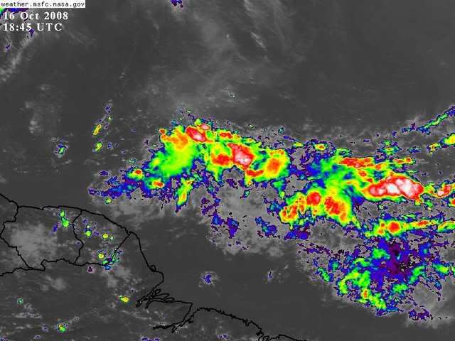
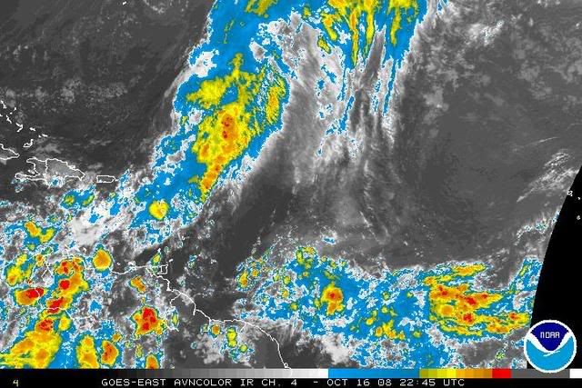
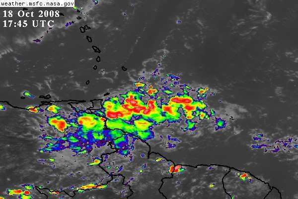
TROPICAL WAVE IS LOCATED ABOUT 950 MILES EAST-SOUTHEAST OF THE
SOUTHERN WINDWARD ISLANDS. SOME SLOW DEVELOPMENT OF THE SYSTEM IS
POSSIBLE DURING THE NEXT COUPLE OF DAYS AS IT MOVES WESTWARD AT 10
TO 15 MPH.


THE REMNANT CIRCULATION OF FORMER TROPICAL DEPRESSION SIXTEEN IS
LOCATED INLAND OVER EASTERN GUATEMALA. ALTHOUGH REFORMATION OF A
TROPICAL CYCLONE WILL NOT OCCUR DUE TO LAND INTERACTION...THIS
SYSTEM COULD STILL PRODUCE BRIEF PERIODS OF STRONG GUSTY
WINDS...ESPECIALLY OVER THE GULF OF HONDURAS...ALONG WITH LOCALLY
HEAVY RAINFALL. THESE RAINS COULD CAUSE FLASH FLOODS ACROSS
PORTIONS OF NICARAGUA...HONDURAS...EL SALVADOR...BELIZE...AND
GUATEMALA DURING THE NEXT COUPLE OF DAYS AS THE SYSTEM DRIFTS
WESTWARD.

ELSEWHERE...TROPICAL CYCLONE FORMATION IS NOT EXPECTED DURING THE
NEXT 48 HOURS.

$$

FORECASTER LANDSEA/STEWART
0 likes   

User avatar
Gustywind
Category 5
Category 5
Posts: 12334
Joined: Mon Sep 03, 2007 7:29 am
Location: Baie-Mahault, GUADELOUPE

#2 Postby Gustywind » Thu Oct 16, 2008 2:22 pm

:cheesy: http://www.meteo.fr/temps/domtom/antill ... Tagant.jpg
Another guest after Omar? Waouw another thing to monitor??? i saw this since two days popping nicely, so let's wait and see...
0 likes   

User avatar
Gustywind
Category 5
Category 5
Posts: 12334
Joined: Mon Sep 03, 2007 7:29 am
Location: Baie-Mahault, GUADELOUPE

#3 Postby Gustywind » Thu Oct 16, 2008 2:25 pm

000
AXNT20 KNHC 161750
TWDAT

TROPICAL WEATHER DISCUSSION
NWS TPC/NATIONAL HURRICANE CENTER MIAMI FL
205 PM EDT THU OCT 16 2008

TROPICAL WEATHER DISCUSSION FOR NORTH AMERICA...CENTRAL
AMERICA...GULF OF MEXICO...CARIBBEAN SEA...NORTHERN SECTIONS OF
SOUTH AMERICA...AND ATLANTIC OCEAN TO THE AFRICAN COAST FROM THE
EQUATOR TO 32N. THE FOLLOWING INFORMATION IS BASED ON SATELLITE
IMAGERY...METEOROLOGICAL ANALYSIS...WEATHER OBSERVATIONS...AND
RADAR.

BASED ON 1200 UTC SURFACE ANALYSIS AND SATELLITE IMAGERY THROUGH
1715 UTC.

:rarrow: AN ACTIVE TROPICAL WAVE IS ALONG 45W S OF 14N MOVING W NEAR 10
KT. THE WAVE SHOWS A CLASSIC INVERTED-V PATTERN ON SATELLITE
IMAGERY WITH SCATTERED TO NUMEROUS MODERATE TO ISOLATED STRONG
CONVECTION WITHIN 180-200 NM EITHER SIDE OF THE WAVE AXIS FROM
8N-12N.
0 likes   

User avatar
HURAKAN
Professional-Met
Professional-Met
Posts: 46086
Age: 38
Joined: Thu May 20, 2004 4:34 pm
Location: Key West, FL
Contact:

#4 Postby HURAKAN » Thu Oct 16, 2008 6:30 pm

BEGIN
NHC
invest_al882008.invest
FSTDA
R
U
040
010
0000
200810161749
NONE
NOTIFY=ATRP
END
NONAME, AL, L, , , , , 88, 2008, TD, O, 2008101612, 9999999999, , , , , , METWATCH, , AL882008
AL, 88, 2008101512, , BEST, 0, 76N, 420W, 15, 1013, DB, 0, , 0, 0, 0, 0,
AL, 88, 2008101518, , BEST, 0, 77N, 431W, 15, 1013, DB, 0, , 0, 0, 0, 0,
AL, 88, 2008101600, , BEST, 0, 78N, 444W, 20, 1012, DB, 0, , 0, 0, 0, 0,
AL, 88, 2008101606, , BEST, 0, 79N, 454W, 20, 1012, DB, 0, , 0, 0, 0, 0,
AL, 88, 2008101612, , BEST, 0, 82N, 464W, 20, 1011, DB, 0, , 0, 0, 0, 0, 1013, 180, 75, 0, 0, L, 0, , 0, 0, NONAME, M,
AL, 88, 2008101618, , BEST, 0, 85N, 475W, 20, 1011, DB, 34, NEQ, 0, 0, 0, 0, 1013, 180, 75, 0, 0, L, 0, , 0, 0, NONAME, M,


Internal invest.

Image
0 likes   

User avatar
HURAKAN
Professional-Met
Professional-Met
Posts: 46086
Age: 38
Joined: Thu May 20, 2004 4:34 pm
Location: Key West, FL
Contact:

Re: Area of Disturbed Weather east of the Lesser Antilles

#5 Postby HURAKAN » Thu Oct 16, 2008 6:42 pm

TROPICAL WEATHER OUTLOOK
NWS TPC/NATIONAL HURRICANE CENTER MIAMI FL
800 PM EDT THU OCT 16 2008

FOR THE NORTH ATLANTIC...CARIBBEAN SEA AND THE GULF OF MEXICO...

THE NATIONAL HURRICANE CENTER IS ISSUING ADVISORIES ON WEAKENING
HURRICANE OMAR...LOCATED ABOUT 350 MILES NORTHEAST OF THE NORTHERN
LEEWARD ISLANDS.

:rarrow: A LARGE AREA OF DISTURBED WEATHER ASSOCIATED WITH A WESTWARD MOVING
TROPICAL WAVE IS LOCATED ABOUT 875 MILES EAST-SOUTHEAST OF THE
SOUTHERN WINDWARD ISLANDS. SOME SLOW DEVELOPMENT OF THE SYSTEM IS
POSSIBLE DURING THE NEXT COUPLE OF DAYS AS IT MOVES WESTWARD AT 10
TO 15 MPH.


THE REMNANT CIRCULATION OF FORMER TROPICAL DEPRESSION SIXTEEN IS
LOCATED INLAND OVER EASTERN GUATEMALA AND WESTERN HONDURAS.
ALTHOUGH REFORMATION OF A TROPICAL CYCLONE WILL NOT OCCUR DUE TO
LAND INTERACTION...THIS SYSTEM COULD STILL PRODUCE BRIEF PERIODS OF
STRONG GUSTY WINDS...ESPECIALLY OVER THE GULF OF HONDURAS...ALONG
WITH LOCALLY HEAVY RAINFALL. THESE RAINS COULD CAUSE FLASH FLOODS
ACROSS PORTIONS OF NICARAGUA...HONDURAS...EL SALVADOR...BELIZE...
AND GUATEMALA DURING THE NEXT COUPLE OF DAYS AS THE SYSTEM DRIFTS
WESTWARD.

ELSEWHERE...TROPICAL CYCLONE FORMATION IS NOT EXPECTED DURING THE
NEXT 48 HOURS.

$$

FORECASTER BEVEN
0 likes   

User avatar
gatorcane
S2K Supporter
S2K Supporter
Posts: 23691
Age: 47
Joined: Sun Mar 13, 2005 3:54 pm
Location: Boca Raton, FL

#6 Postby gatorcane » Thu Oct 16, 2008 10:06 pm

This area will need to be watched because plenty of mid-level ridging is expected to build in across the South Central Atlantic to the Western Caribbean for the next 10+ days (maybe even out to 384 hours). I just checked the 18Z.

It certainly seems like summer is holding strong across the tropical atlantic. Right now this disturbed area does not look impressive at all. The NHC must see something nobody else does as nobody has commented on this area. Yet for the prospects of slow development of a westward moving system, I'm a bit surprised.

Yet I digress, if it were to develop (and that is a BIG IF), its certainly heading west for quite a while if you take the GFS 500MB flow guidance out through 144 hours.
0 likes   

User avatar
TheEuropean
Professional-Met
Professional-Met
Posts: 1796
Age: 59
Joined: Tue Sep 20, 2005 3:17 pm
Location: Voerde, Germany
Contact:

Re: Area of Disturbed Weather east of the Lesser Antilles

#7 Postby TheEuropean » Fri Oct 17, 2008 1:52 am

000
ABNT20 KNHC 170528
TWOAT
TROPICAL WEATHER OUTLOOK
NWS TPC/NATIONAL HURRICANE CENTER MIAMI FL
200 AM EDT FRI OCT 17 2008

FOR THE NORTH ATLANTIC...CARIBBEAN SEA AND THE GULF OF MEXICO...

THE NATIONAL HURRICANE CENTER IS ISSUING ADVISORIES ON TROPICAL
STORM OMAR...LOCATED ABOUT 715 MILES SOUTHEAST OF BERMUDA.

Image CLOUDINESS AND SHOWERS ASSOCIATED WITH A WESTWARD MOVING TROPICAL
WAVE ARE LOCATED ABOUT 650 MILES EAST-SOUTHEAST OF THE SOUTHERN
WINDWARD ISLANDS. THERE ARE NO SIGNS OF ORGANIZATION AND
DEVELOPMENT...IF ANY...WILL BE SLOW TO OCCUR.


THE REMNANT CIRCULATION OF FORMER TROPICAL DEPRESSION SIXTEEN IS
CENTERED INLAND OVER CENTRAL AMERICA. THIS SYSTEM IS NEARLY
STATIONARY AND WILL CONTINUE TO PRODUCE LOCALLY HEAVY RAINS ACROSS
PORTIONS OF NICARAGUA...HONDURAS...EL SALVADOR...BELIZE...
AND GUATEMALA DURING THE NEXT COUPLE OF DAYS. THESE RAINS COULD
CAUSE FLASH FLOODS AND MUD SLIDES.

ELSEWHERE...TROPICAL CYCLONE FORMATION IS NOT EXPECTED DURING THE
NEXT 48 HOURS.

$$

FORECASTER AVILA
0 likes   

User avatar
Gustywind
Category 5
Category 5
Posts: 12334
Joined: Mon Sep 03, 2007 7:29 am
Location: Baie-Mahault, GUADELOUPE

#8 Postby Gustywind » Fri Oct 17, 2008 5:52 am

000
AXNT20 KNHC 170603
TWDAT

TROPICAL WEATHER DISCUSSION
NWS TPC/NATIONAL HURRICANE CENTER MIAMI FL
205 AM EDT FRI OCT 17 2008

TROPICAL WEATHER DISCUSSION FOR NORTH AMERICA...CENTRAL
AMERICA...GULF OF MEXICO...CARIBBEAN SEA...NORTHERN SECTIONS
OF SOUTH AMERICA...AND ATLANTIC OCEAN TO THE AFRICAN COAST
FROM THE EQUATOR TO 32N. THE FOLLOWING INFORMATION IS
BASED ON SATELLITE IMAGERY...METEOROLOGICAL ANALYSIS...
WEATHER OBSERVATIONS...AND RADAR.

BASED ON 0000 UTC SURFACE ANALYSIS AND SATELLITE IMAGERY
THROUGH 0515 UTC.
...TROPICAL WAVES...

:rarrow: AN ATLANTIC OCEAN TROPICAL WAVE IS ALONG 49W/50W SOUTH OF 16N
MOVING WEST 10 TO 15 KT. SCATTERED MODERATE SHOWERS TO ISOLATED
STRONG THUNDERSTORMS ARE FROM 5N TO 12N BETWEEN 47W AND 56W.
0 likes   

Sanibel
Category 5
Category 5
Posts: 10375
Joined: Mon Aug 30, 2004 11:06 pm
Location: Offshore SW Florida

Re: Area of Disturbed Weather east of the Lesser Antilles

#9 Postby Sanibel » Fri Oct 17, 2008 9:30 am

I can see why they are looking at it. It has signs of potential in the cloud movements and depth, however you can see shear is far down into the hurricane belt, and late season latent conditions are marginal for development, just from the weak behavior. It does look something like the scattered persistence of Kyle and Omar if it hangs on in fading seasonal conditions.
0 likes   

User avatar
Gustywind
Category 5
Category 5
Posts: 12334
Joined: Mon Sep 03, 2007 7:29 am
Location: Baie-Mahault, GUADELOUPE

#10 Postby Gustywind » Fri Oct 17, 2008 9:49 am

Always keep an eye on this is the rule...
0 likes   

FireBird
Tropical Storm
Tropical Storm
Posts: 133
Joined: Tue Jul 22, 2008 1:44 pm
Location: NorthWest Trinidad, SE Caribbean

Re: Area of Disturbed Weather east of the Lesser Antilles

#11 Postby FireBird » Fri Oct 17, 2008 11:46 am

The met office here (Trinidad) has indicated to look out for flash flooding with the passage of this wave, and gusty winds near showers. I keep my radar up esp. when NHC says there's possibility of strong thunderstorms - even though things don't look impressive right now.
If the wave happens to live past us (shear around here is a killer), then there may be some remote possibility for development. It just seems to me that anything alive after passing my latitude tends to have some guts to it (or jus' plain bad mind as we would say)...... :wink:

b]The posts in this forum are NOT official forecast and should not be used as such. They are just the opinion of the poster and may or may not be backed by sound meteorological data. They are NOT endorsed by any professional institution or storm2k.org. For official information, please refer to the NHC and NWS products.
0 likes   

User avatar
HURAKAN
Professional-Met
Professional-Met
Posts: 46086
Age: 38
Joined: Thu May 20, 2004 4:34 pm
Location: Key West, FL
Contact:

Re: Area of Disturbed Weather east of the Lesser Antilles

#12 Postby HURAKAN » Sat Oct 18, 2008 1:06 pm

Image

TROPICAL WEATHER DISCUSSION
NWS TPC/NATIONAL HURRICANE CENTER MIAMI FL
205 PM EDT SAT OCT 18 2008

TROPICAL WAVE IS ALONG 54W S OF 15N MOVING W NEAR 10 KT. WEAK
INVERTED-V CURVATURE IS OBSERVED ON SATELLITE IMAGERY WITH A
LOW/MID LEVEL LOW ALONG THE WAVE NEAR 9N. ANY CONVECTION IN THE
VICINITY IS ASSOCIATED WITH THE ITCZ.
0 likes   

User avatar
wxman57
Moderator-Pro Met
Moderator-Pro Met
Posts: 22975
Age: 67
Joined: Sat Jun 21, 2003 8:06 pm
Location: Houston, TX (southwest)

Re: Area of Disturbed Weather east of the Lesser Antilles

#13 Postby wxman57 » Sun Oct 19, 2008 10:22 am

Development chances slim to none.
0 likes   


Return to “Talkin' Tropics”

Who is online

Users browsing this forum: No registered users and 23 guests