Orlando hit 43F this morning. That ties the all-time record low for the month of October originally set in 1957. Pretty impressive.
Also, equally impressive, Ocala hit 32F this morning. This freeze comes about a month ahead of when their average first freeze should take place.
All in all, this was a very cold event for central and north Florida. Down in southern Florida it was not quite as cold as it could have been (due to clouds), but 55F is still not all that shabby for Miami this early in the season.
Florida Weather
Moderator: S2k Moderators
Forum rules

The posts in this forum are NOT official forecast and should not be used as such. They are just the opinion of the poster and may or may not be backed by sound meteorological data. They are NOT endorsed by any professional institution or STORM2K.
-
Extremeweatherguy

- Category 5

- Posts: 11095
- Joined: Mon Oct 10, 2005 8:13 pm
- Location: Florida
Re: Florida Weather Thread: Coldest air of the season on the way
NWS Miami made a somewhat bold prediction that a new all-time low temp for October of 44 deg was going to take place last night in West Palm Beach and a new all-time October low of 43 deg would take place in Naples.
Stating this was the ‘kiss of death’ for that…the temp pretty much stopped dropping for the rest of the night....but records for the date were set.
NATIONAL WEATHER SERVICE MIAMI FL
1017 PM EDT TUE OCT 28 2008
.UPDATE..THE FORECAST LOW FOR PBI WILL BE 44 FOR TONIGHT...AND
THIS WILL ALLOW FOR WEST PALM BEACH TO FALL BELOW THE ALL TIME
LOW RECORD FOR THE MONTH WHICH IS 46 DEGREES SET IN 1968.
APF (Naples) LOW WILL NOW BE 43 DEGREES FOR TONIGHT WHICH WILL ALSO BE BELOW THE
ALL TIME RECORD LOW FOR THE MONTH AT 46 DEGREES SET IN 2000.
Turned out to be 6 degrees warmer than forecast in West Palm and 5 degrees warmer than forecast in Naples....
...RECORD LOW TEMPERATURE SET AT WEST PALM BEACH...
A RECORD LOW TEMPERATURE OF 50 DEGREES WAS SET AT WEST PALM BEACH TODAY.
THIS BREAKS THE OLD RECORD OF 51 SET IN 1944.
...RECORD LOW TEMPERATURE SET AT NAPLES...
A RECORD LOW TEMPERATURE OF 48 DEGREES WAS SET AT NAPLES TODAY.
THIS BREAKS THE OLD RECORD OF 51 SET IN 1943.
Last edited by jinftl on Wed Oct 29, 2008 8:29 am, edited 1 time in total.
0 likes
-
gatorcane

- S2K Supporter

- Posts: 23708
- Age: 48
- Joined: Sun Mar 13, 2005 3:54 pm
- Location: Boca Raton, FL
Re: Florida Weather Thread: Coldest air of the season on the way
jinftl wrote:NWS Miami made a somewhat bold prediction that a new all-time low temp for October of 43 deg was going to take place last night in West Palm Beach. This was the ‘kiss of death’ for that…the temp pretty much stopped dropping for the rest of the night.
NATIONAL WEATHER SERVICE MIAMI FL
1017 PM EDT TUE OCT 28 2008
.UPDATE..THE FORECAST LOW FOR PBI WILL BE 44 FOR TONIGHT...AND
THIS WILL ALLOW FOR WEST PALM BEACH TO FALL BELOW THE ALL TIME
LOW RECORD FOR THE MONTH WHICH IS 46 DEGREES SET IN 1968. APF LOW
WILL NOW BE 43 DEGREES FOR TONIGHT WHICH WILL ALSO BE BELOW THE
ALL TIME RECORD LOW FOR THE MONTH AT 46 DEGREES SET IN 2000.
Turned out to be 7 degrees warmer than forecast…
...RECORD LOW TEMPERATURE SET AT WEST PALM BEACH...
A RECORD LOW TEMPERATURE OF 50 DEGREES WAS SET AT WEST PALM BEACH TODAY.
THIS BREAKS THE OLD RECORD OF 51 SET IN 1944.
I have to say I was scratching my head at this prediction. They lowered the projected low temp at PBI and KAPF because they saw the temps dropping more quickly than predicted throughout the evening hours last night...and they mentioned
"good radiational cooling." But when I looked at the WV loops I saw that cloud deck/moisture racing towards South Florida, from the Gulf of Mexico, I knew it wasn't going to happen.
I am curious what NWS Miami is going to say in their updated discussion today on low temps ---
0 likes

Re: Florida Weather Thread: Coldest air of the season on the way
We finally ended up with a low of 35 at my house.
From the morning NWS Tampa discussion:
.CLIMATE...SEVERAL RECORDS WERE BROKEN OR TIED THIS MORNING. THE
RECORD LOWS FOR OCTOBER 29TH ARE BELOW ALONG WITH WHAT OCCURRED
TODAY:
STATION RECORD VALUE TODAY`S LOW
TPA..............44 (1910) 42
FMY..............47 (1910) 47
SPG..............49 (1952) 51
BRADENTON 5 ESE..48 (1987) 44
LAKELAND.........48 (1957) 38
A COUPLE OF RECORDS ARE IN DANGER OF BEING BROKEN TOMORROW MORNING
AS WELL. THE RECORD LOWS FOR OCTOBER 30TH ARE BELOW ALONG WITH THE
CURRENT FORECAST LOW:
STATION RECORD VALUE FORECAST VALUE
TPA..............41 (1963) 47
FMY..............50 (1953) 49
SPG..............48 (1952) 53
BRADENTON 5 ESE..45 (1952) 47
LAKELAND.........46 (1952) 42
0 likes
Re: Florida Weather Thread: Coldest air of the season on the way
Between 10pm and midnight last night, the temp at my house in Fort Lauderdale (approx 2 miles inland) went from 58 to 59 degrees. That was a clear indication that, although the winds had died down, a ‘typical’ scenario of radiational cooling that we can see in the winter was not taking place. Low at my house was 56.8F.
gatorcane wrote:jinftl wrote:NWS Miami made a somewhat bold prediction that a new all-time low temp for October of 43 deg was going to take place last night in West Palm Beach. This was the ‘kiss of death’ for that…the temp pretty much stopped dropping for the rest of the night.
NATIONAL WEATHER SERVICE MIAMI FL
1017 PM EDT TUE OCT 28 2008
.UPDATE..THE FORECAST LOW FOR PBI WILL BE 44 FOR TONIGHT...AND
THIS WILL ALLOW FOR WEST PALM BEACH TO FALL BELOW THE ALL TIME
LOW RECORD FOR THE MONTH WHICH IS 46 DEGREES SET IN 1968. APF LOW
WILL NOW BE 43 DEGREES FOR TONIGHT WHICH WILL ALSO BE BELOW THE
ALL TIME RECORD LOW FOR THE MONTH AT 46 DEGREES SET IN 2000.
Turned out to be 7 degrees warmer than forecast…
...RECORD LOW TEMPERATURE SET AT WEST PALM BEACH...
A RECORD LOW TEMPERATURE OF 50 DEGREES WAS SET AT WEST PALM BEACH TODAY.
THIS BREAKS THE OLD RECORD OF 51 SET IN 1944.
I have to say I was scratching my head at this prediction. They lowered the projected low temp at PBI and KAPF because they saw the temps dropping more quickly than predicted throughout the evening hours last night...and they mentioned
"good radiational cooling." But when I looked at the WV loops I saw that cloud deck/moisture racing towards South Florida, from the Gulf of Mexico, I knew it wasn't going to happen.
I am curious what NWS Miami is going to say in their updated discussion today on low temps ---
0 likes
-
JonathanBelles
- Professional-Met

- Posts: 11430
- Age: 35
- Joined: Sat Dec 24, 2005 9:00 pm
- Location: School: Florida State University (Tallahassee, FL) Home: St. Petersburg, Florida
- Contact:
-
Extremeweatherguy
- Category 5
- Posts: 11095
- Joined: Mon Oct 10, 2005 8:13 pm
- Location: Florida
To put this event into perspective for Orlando: Hitting 43F in October, like you did this morning, is comparable to hitting 19F in January (which is the all-time record low for that month). That is pretty wild to think about.
After the chilly start today, it looks like the state has one more chilly night in store before a warmup begins. Here are the forecasted lows for tomorrow morning...
Tallahassee: 40F
Ocala: 36F
Orlando: 45F
Tampa: 46F
Naples: 54F
Miami: 58F
Key West: 65F
Not quite as cold as last night, but still unusually cold for this time of year.
0 likes
Re: Florida Weather Thread: Coldest air of the season on the way
Record low in Miami tonight is 45 degrees…so no chance of that being beat…forecast has been inching up from the mid to the upper 50’s now….after last night’s temps bottomed out 5-7 degrees above the forecast (Miami and Fort Lauderdale got to 55 deg), I would not be surprised to see some areas close to the immediate coast in south florida not get below 60 tonight. Interior regions of south florida have one more cool night ahead in the 50 range plus or minus.
0 likes
Re: Florida Weather Thread: Coldest air of the season on the way
Low of 49 degrees on our digital thermometer in the Gulf here.
Snaps in temperature and unseasonable weather (may be) signs of global warming.
Sun is still warm out of the wind.
Snaps in temperature and unseasonable weather (may be) signs of global warming.
Sun is still warm out of the wind.
0 likes
-
gatorcane
- S2K Supporter
- Posts: 23708
- Age: 48
- Joined: Sun Mar 13, 2005 3:54 pm
- Location: Boca Raton, FL
Re: Florida Weather Thread: Coldest air of the season on the way
jinftl wrote:Record low in Miami tonight is 45 degrees…so no chance of that being beat…forecast has been inching up from the mid to the upper 50’s now….after last night’s temps bottomed out 5-7 degrees above the forecast (Miami and Fort Lauderdale got to 55 deg), I would not be surprised to see some areas close to the immediate coast in south florida not get below 60 tonight. Interior regions of south florida have one more cool night ahead in the 50 range plus or minus.
Should any kind of NE wind component kick in tonight its likely low temps will be in the 60s across coastal SE Florida. If the winds stay light or out of the NW or N, low temps may be able to get down into the 50s. Tonigth may be one of those typical nights where SE Florida is some 10-20 degrees warmer than the rest of the state because of the presence of the Gulf stream current right along Palm Beach County through Miami-Dade.
At least we got one "cold" night in Southeast Florida. It's a pretty rare thing here.
Last edited by gatorcane on Wed Oct 29, 2008 10:49 am, edited 3 times in total.
0 likes
-
gatorcane
- S2K Supporter
- Posts: 23708
- Age: 48
- Joined: Sun Mar 13, 2005 3:54 pm
- Location: Boca Raton, FL
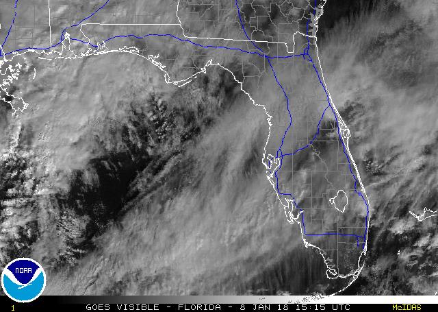
You can see from this graphic the winds are veering to the NE across much of the SE GOM and the FL straits. As the day moves on, wind vectors across SE Florida will veer to the NE (along with some influence of daytime heating)...humidities will noticeably increase and temps will warm.
Basically the cold front will be over for much of SE Florida by later today.

Another thing to note is as the winds veer to the NE, its likely we will see a deck of stratocumulus move ashore from the Atlantic waters. You can see those clouds lurking offshore on this visible. These clouds *should* keep temps in SE Florida above 60F tonight:
Basically the cold front will be over for much of SE Florida by later today.
Another thing to note is as the winds veer to the NE, its likely we will see a deck of stratocumulus move ashore from the Atlantic waters. You can see those clouds lurking offshore on this visible. These clouds *should* keep temps in SE Florida above 60F tonight:
0 likes
Re: Florida Weather Thread: Coldest air of the season on the way
Latest temps…..number in ( ) is difference from temp 24 hours ago….the warm-up has begun. In addition, dewpoints are rising...between 50 and 55 deg across south florida....
FLORIDA REGIONAL WEATHER ROUNDUP
NATIONAL WEATHER SERVICE TAMPA BAY RUSKIN FL
1200 PM EDT WED OCT 29 2008
PENSACOLA SUNNY 54 (+1)
TALLAHASSEE SUNNY 56 (+2)
GAINESVILLE SUNNY 55 (+1)
JACKSONVILLE SUNNY 56 (+2)
ORLANDO INTL MOSUNNY 59 (+2)
MELBOURNE SUNNY 63 (+3)
VERO BEACH SUNNY 66 (+6)
FT PIERCE SUNNY 65 (+5)
TAMPA MOSUNNY 60 (+0)
SARASOTA SUNNY 60 (+2)
NAPLES SUNNY 66 (+5)
KEY WEST INTL MOSUNNY 68 (+1)
FT LAUDERDALE SUNNY 70 (+4)
W PALM BEACH MOSUNNY 68 (+5)
MIAMI MOSUNNY 68 (+3)
0 likes
Re: Florida Weather Thread: Coldest air of the season on the way
Latest temps....number in ( ) is the change in temp from 24 hours ago
FLORIDA REGIONAL WEATHER ROUNDUP
NATIONAL WEATHER SERVICE TAMPA BAY RUSKIN FL
100 PM EDT WED OCT 29 2008
PENSACOLA SUNNY 58 (+3)
TALLAHASSEE SUNNY 58 (+3)
GAINESVILLE SUNNY 58 (-2)
JACKSONVILLE SUNNY 58 (+3)
ORLANDO INTL MOSUNNY 61 (+2)
DAYTONA BEACH SUNNY 61 (+1)
JFK SPACE CTR MOSUNNY 64 (+3)
MELBOURNE SUNNY 64 (+3)
VERO BEACH SUNNY 68 (+5)
FT PIERCE SUNNY 67 (+5)
TAMPA MOSUNNY 63 (+3)
SARASOTA SUNNY 62 (+2)
FT MYERS SUNNY 66 (+4)
KEY WEST INTL MOSUNNY 69 (+0)
W PALM BEACH MOSUNNY 70 (+5)
FT LAUDERDALE SUNNY 73 (+5)
MIAMI MOSUNNY 72 (+6) (NE wind now)
0 likes
-
MiamiensisWx
Re: Florida Weather Thread: Coldest air of the season on the way
gatorcane wrote:Should any kind of NE wind component kick in tonight its likely low temps will be in the 60s across coastal SE Florida. If the winds stay light or out of the NW or N, low temps may be able to get down into the 50s. Tonigth may be one of those typical nights where SE Florida is some 10-20 degrees warmer than the rest of the state because of the presence of the Gulf stream current right along Palm Beach County through Miami-Dade.
At least we got one "cold" night in Southeast Florida. It's a pretty rare thing here.
Actually, October lows (colder than last night's event) are not climatologically unusual in southern Florida, based on long term historical data. In addition, if you look at preceding history, winter outbreaks with temperatures below <36-38 F across coastal SE Florida have been common during several periods. The late 1800s and several portions of the 20th century featured widespread, severe, and persistent cold outbreaks across southern Florida. These outbreaks were common during +PDO regimes, unlike -PDO regimes. Significant cold events have become significantly less frequent during the most recent decade, since we have entered another long term -PDO phase.
The 2000s have been very different than the 1970s-1990s down here in SE Florida... cold events have been profoundly shorter and less severe.
0 likes
Re: Florida Weather Thread: Coldest air of the season on the way
FLORIDA REGIONAL WEATHER ROUNDUP
NATIONAL WEATHER SERVICE TAMPA BAY RUSKIN FL
300 PM EDT WED OCT 29 2008
PENSACOLA SUNNY 61
APALACHICOLA SUNNY 63
TALLAHASSEE SUNNY 62
GAINESVILLE SUNNY 62
JACKSONVILLE SUNNY 63
ST AUGUSTINE SUNNY 63
ORLANDO INTL SUNNY 65
DAYTONA BEACH SUNNY 65
MELBOURNE SUNNY 67
VERO BEACH SUNNY 68
FT PIERCE MOSUNNY 68
TAMPA MOSUNNY 65
FT MYERS SUNNY 69
KEY WEST INTL CLOUDY 70
W PALM BEACH MOSUNNY 73
FT LAUDERDALE SUNNY 74
PEMBROKE PINES MOSUNNY 76
OPA LOCKA MOSUNNY 74
MIAMI MOSUNNY 75
0 likes
-
gatorcane
- S2K Supporter
- Posts: 23708
- Age: 48
- Joined: Sun Mar 13, 2005 3:54 pm
- Location: Boca Raton, FL
Looking at current dewpoints across Central and South Florida, you can already see that the SE Florida should be quite a bit warmer than the rest of the state tonight for overnight lows, probably a 10-20 degree difference and most lows staying in the 60s along the immediate coast with some scattered mid to upper 50s inland.
Dewpoints are still comfortable here in SE Florida but are on the rise and by tomorrow night it probably will be back to AC again...and for the forseeable future.

Dewpoints are still comfortable here in SE Florida but are on the rise and by tomorrow night it probably will be back to AC again...and for the forseeable future.
0 likes
Re: Florida Weather Thread: Coldest air of the season on the way
AREA FORECAST DISCUSSION...UPDATED
NATIONAL WEATHER SERVICE MIAMI FL
917 PM EDT WED OCT 29 2008
.UPDATE...
THE DEW POINTS IN THE SOUTHERN INTERIOR AREAS WERE AROUND 50...WHILE
ALONG THE EAST COAST METRO AREAS THEY HAVE BEEN IN THE LOWER TO
MID 50S. HOWEVER...THE CLOUDS OVER THE SOUTHERN AREAS WILL KEEP
THE SOME OF THE HEAT FROM RADIATING OUT TONIGHT. SO HAVE INCREASED
THE LOW TEMPS A LITTLE BIT OVER THE SOUTHEAST COAST AND THE
SOUTHERN INTERIOR AREAS FOR TONIGHT.
0 likes
I'm surprised no one mentioned last night's low of 29 in Brooksville (Hernando county). For reference Brooksville is at the same latitude as Orlando. In my view that temp is whole lot more impressive than 32 in Ocala. Once again central Florida's icebox delivers the goods... no one else in the central part of the state can compete. I had low 40's in my neighborhood and that was bad enough...looking forward to a more normal temp regime returning.. great weather ahead.
0 likes
-
gatorcane
- S2K Supporter
- Posts: 23708
- Age: 48
- Joined: Sun Mar 13, 2005 3:54 pm
- Location: Boca Raton, FL
Re:
psyclone wrote:I'm surprised no one mentioned last night's low of 29 in Brooksville (Hernando county). For reference Brooksville is at the same latitude as Orlando. In my view that temp is whole lot more impressive than 32 in Ocala. Once again central Florida's icebox delivers the goods... no one else in the central part of the state can compete. I had low 40's in my neighborhood and that was bad enough...looking forward to a more normal temp regime returning.. great weather ahead.
Palm Harbor where you live is one of the "cold spots" in the Tampa Bay area and Pinellas County. It's amazing that if you head just 25 miles south to the southern part of Pinellas County, it can be significantly warmer because of the modifying effect of the bay. Even if you head about 15-20 minuite south to south of Gulf-to-Bay Blvd, you start to get the modifying effect. I've always compared the macroclimate of Pinellas County to that of the peninsula of FL. SE Pinellas County is the "SE Florida" of Pinellas County while Palm Harbor/Tarpon Springs would be the Ocala/Gainesville of Pinellas County.
For example let's look at the difference between Tampa and St. Petersburg last night for lows. That's a significant 6 degree difference.
Tampa: low 49
St. Petersburg (Whitted Airport on the Bay): low 55
0 likes
-
Extremeweatherguy
- Category 5
- Posts: 11095
- Joined: Mon Oct 10, 2005 8:13 pm
- Location: Florida
Return to “USA & Caribbean Weather”
Who is online
Users browsing this forum: Stratton23 and 37 guests