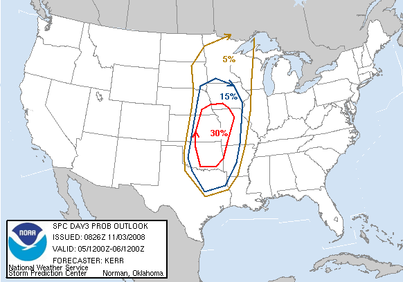
Severe weather - November 5-6, Midwest/South

U.S. & Caribbean Weather Discussions and Severe Weather Events

Moderator: S2k Moderators

Forum rules

The posts in this forum are NOT official forecast and should not be used as such. They are just the opinion of the poster and may or may not be backed by sound meteorological data. They are NOT endorsed by any professional institution or STORM2K.

Help Support Storm2K
Message
Author
CKB 38
Tropical Wave
Tropical Wave
Posts: 7
Joined: Sun Nov 02, 2008 2:30 pm

Re: Severe weather/tornado outbreak? November 5-6, Midwest/South

#21 Postby CKB 38 » Sun Nov 02, 2008 11:40 pm

CrazyC83 wrote:
CKB 38 wrote:im really excited to see how this all plays out!!! by the way im new to this forum...i live in peoria illinios...and i LOVE severe weather!!!

what do u think the chances of us seein some pretty decent severe weather in central illinois r for like wed night maybe...


Probably not much until early Thursday with the squall line. Thursday afternoon MAYBE another round, but that would need greater moisture return (models are showing not too much then).


aight thanks man...appreciate...what time u think early thurs? like overnight hrs??? do u think the chance is slim or acutally decent?
0 likes   

CrazyC83
Professional-Met
Professional-Met
Posts: 34001
Joined: Tue Mar 07, 2006 11:57 pm
Location: Deep South, for the first time!

Re: Severe weather/tornado outbreak? November 5-6, Midwest/South

#22 Postby CrazyC83 » Mon Nov 03, 2008 1:08 am

CKB 38 wrote:
CrazyC83 wrote:
CKB 38 wrote:im really excited to see how this all plays out!!! by the way im new to this forum...i live in peoria illinios...and i LOVE severe weather!!!

what do u think the chances of us seein some pretty decent severe weather in central illinois r for like wed night maybe...


Probably not much until early Thursday with the squall line. Thursday afternoon MAYBE another round, but that would need greater moisture return (models are showing not too much then).


aight thanks man...appreciate...what time u think early thurs? like overnight hrs??? do u think the chance is slim or acutally decent?


Squall line would most likely be overnight towards daybreak, maybe into the early morning hours. Redevelopment would be in the mid to late afternoon, but I would give the chance of that around 30% at this point.

Anyway, for the upcoming Day 3, I'm guessing a high-end slight risk.
0 likes   

Shockwave
Tropical Storm
Tropical Storm
Posts: 167
Joined: Fri Jul 25, 2008 7:33 am
Location: Lafayette, TN
Contact:

Re:

#23 Postby Shockwave » Mon Nov 03, 2008 6:31 am

CrazyC83 wrote:00Z run:

EHI - peaking around 3.5 (maybe 4.0 locally)
Helicity - near 550 (up to 950 to the west, if that can line up with the severe weather - yikes!!!)
CAPE - approaching 2,000 J/kg2 in the central area
LI - around -7 to -8 over south-central Kansas
Dewpoints - Low to mid-60s in Kansas and Oklahoma, high 50s elsewhere
Temps - Mostly low to mid-70s except near 80 in southern areas (70s as far north as Lake Superior!)

Not pretty. It's the most ominous run yet. I'm guessing a 30%-hatched for the Day 3 outlook by the SPC. Outside chance at a Day 3 moderate risk.


Yeah, those numbers are looking pretty errie for this time of year. I wouldn't be surprised at all if the SPC does go with a MDT risk for Weds. From what I've been reading, south-central KS and Northern OK looks to be the best place to chase from. My chasing spots would form a triangle around Arkansas City, KS; eastward to around Coffeyville, KS; and southward to Ponca City, OK. That would be my chase zone.
0 likes   

User avatar
Dave
Retired Staff
Retired Staff
Posts: 13442
Age: 74
Joined: Tue Aug 01, 2006 3:57 pm
Location: Milan Indiana
Contact:

#24 Postby Dave » Mon Nov 03, 2008 8:11 am

Image

SPC AC 030826

DAY 3 CONVECTIVE OUTLOOK
NWS STORM PREDICTION CENTER NORMAN OK
0226 AM CST MON NOV 03 2008

VALID 051200Z - 061200Z

...THERE IS A SLGT RISK OF SVR TSTMS WED/WED NIGHT ACROSS PARTS OF
THE PLAINS AND LWR/MID MO VALLEY....

...SYNOPSIS...
WHILE A FAIRLY DEEP LOW/MID-LEVEL CYCLONE WITHIN A SOUTHERN BRANCH
OF SPLIT POLAR WESTERLIES ONLY VERY SLOWLY SHIFTS EAST OF THE
SOUTHERN MID ATLANTIC COAST...MODELS INDICATE THAT THE AXIS OF AN
AMPLIFIED UPSTREAM UPPER TROUGH WILL SHIFT EAST OF THE ROCKIES INTO
THE PLAINS DURING THIS FORECAST PERIOD. THIS IS PROGGED TO OCCUR AS
AN EMBEDDED POLAR JET CORE...AND ASSOCIATED PRIMARY MID-LEVEL
IMPULSE...PROGRESS THROUGH THE BASE OF THE UPPER TROUGH...AND
UPSTREAM RIDGING BEGINS TO BUILD INTO THE PACIFIC COAST STATES.
WHILE THE DEEP CYCLONE ACCOMPANYING THE LARGER SCALE TROUGH MAY NOT
DEEPEN SIGNIFICANTLY FURTHER...A STRONG COLD FRONT APPEARS LIKELY TO
SURGE TO THE LEE OF THE ROCKIES...THROUGH MUCH OF THE PLAINS BY 12Z
THURSDAY. THIS IS EXPECTED TO BE PRECEDED BY A MORE SUBSTANTIVE
RETURN FLOW OF MOISTURE OFF THE GULF OF MEXICO...WHICH MAY
CONTRIBUTE TO AN OUTBREAK OF SEVERE STORMS LATE WEDNESDAY AFTERNOON
AND WEDNESDAY NIGHT.

...PLAINS/MISSISSIPPI VALLEY...
THE STRENGTH OF MID-LEVEL INHIBITION ASSOCIATED WITH AN ELEVATED
MIXED LAYER EMANATING FROM THE PLATEAU REGION...THE MAGNITUDE OF THE
LOW-LEVEL MOISTURE RETURN THROUGH THE PLAINS...AND SUBTLE
DIFFERENCES AMONG THE MODELS CONCERNING SMALLER SCALE DETAILS OF THE
LARGE SCALE PATTERN EVOLUTION...ARE ALL UNCERTAINTIES WHICH WILL
AFFECT THE SEVERE POTENTIAL FOR THIS PERIOD. BUT...GUIDANCE
CONTINUES TO SUGGEST A WINDOW OF OPPORTUNITY WILL EXIST FOR THE
DEVELOPMENT OF SCATTERED SUPERCELLS ALONG A PRE-FRONTAL DRY LINE
ACROSS THE CENTRAL PLAINS LATE WEDNESDAY AFTERNOON. SUFFICIENT
MOISTENING AND HEATING MAY OCCUR FOR MIXED LAYER CAPE OF 500-1000
J/KG ACROSS PARTS OF CENTRAL/EASTERN OKLAHOMA AND KANSAS...PERHAPS
FARTHER NORTHWARD INTO THE MID MISSOURI VALLEY. AND...DEEP LAYER
SHEAR BENEATH THE 50-70+ KT SOUTHWESTERLY 500 MB JET STREAK WILL BE
STRONG...WITH LARGE CLOCKWISE CURVED LOW-LEVEL HODOGRAPHS NEAR A
30-50+ KT SOUTHERLY 850 JET.

FLOW FIELDS ARE PROGGED TO STRENGTHEN FURTHER INTO WEDNESDAY EVENING
AS THE APPROACHING UPPER JET CORE BEGINS TO NOSE EAST OF THE
DIFLUENT UPPER TROUGH AXIS. COUPLED WITH STRENGTHENING LOW-LEVEL
FORCING AS THE SURFACE COLD FRONT OVERTAKES THE DRY LINE AND SURGES
TOWARD THE MISSISSIPPI VALLEY AND GULF COAST... THE EVOLUTION OF AN
EXTENSIVE SQUALL LINE APPEARS POSSIBLE. THIS IS EXPECTED TO
INCREASE THE SEVERE POTENTIAL FOR A PERIOD WEDNESDAY
EVENING...PARTICULARLY IN THE FORM OF DAMAGING WINDS AND LARGE
HAIL...ACROSS THE SOUTHEASTERN PLAINS INTO THE LOWER MISSOURI
VALLEY/OZARK PLATEAU AND ARKLATEX...WHERE A LINGERING SEVERE THREAT
MAY CONTINUE INTO EARLY THURSDAY.

..KERR.. 11/03/2008
0 likes   

CrazyC83
Professional-Met
Professional-Met
Posts: 34001
Joined: Tue Mar 07, 2006 11:57 pm
Location: Deep South, for the first time!

#25 Postby CrazyC83 » Mon Nov 03, 2008 11:33 am

I don't really agree with the winds and hail being the main threat considering the amount of shear...
0 likes   

User avatar
somethingfunny
ChatStaff
ChatStaff
Posts: 3926
Age: 36
Joined: Thu May 31, 2007 10:30 pm
Location: McKinney, Texas

Re: Severe weather/tornado outbreak? November 5-6, Midwest/South

#26 Postby somethingfunny » Mon Nov 03, 2008 12:05 pm

There it is. We always get one before the seasons really change. :)
0 likes   

CrazyC83
Professional-Met
Professional-Met
Posts: 34001
Joined: Tue Mar 07, 2006 11:57 pm
Location: Deep South, for the first time!

Re: Severe weather/tornado outbreak? November 5-6, Midwest/South

#27 Postby CrazyC83 » Mon Nov 03, 2008 12:10 pm

somethingfunny wrote:There it is. We always get one before the seasons really change. :)


Looking at ultra-long range models, it may not be the last one. The November 14-18 timeframe looks interesting as well...
0 likes   

User avatar
somethingfunny
ChatStaff
ChatStaff
Posts: 3926
Age: 36
Joined: Thu May 31, 2007 10:30 pm
Location: McKinney, Texas

Re: Severe weather/tornado outbreak? November 5-6, Midwest/South

#28 Postby somethingfunny » Mon Nov 03, 2008 12:30 pm

CrazyC83 wrote:
somethingfunny wrote:There it is. We always get one before the seasons really change. :)


Looking at ultra-long range models, it may not be the last one. The November 14-18 timeframe looks interesting as well...


I had a feeling. This one looks too far north...the dry air down here will probably put a fizzle on any squall line near the Red River....so the severe season-switcher should be coming with a later front.
0 likes   

CrazyC83
Professional-Met
Professional-Met
Posts: 34001
Joined: Tue Mar 07, 2006 11:57 pm
Location: Deep South, for the first time!

Re: Severe weather/tornado outbreak? November 5-6, Midwest/South

#29 Postby CrazyC83 » Mon Nov 03, 2008 12:55 pm

somethingfunny wrote:
CrazyC83 wrote:
somethingfunny wrote:There it is. We always get one before the seasons really change. :)


Looking at ultra-long range models, it may not be the last one. The November 14-18 timeframe looks interesting as well...


I had a feeling. This one looks too far north...the dry air down here will probably put a fizzle on any squall line near the Red River....so the severe season-switcher should be coming with a later front.


Shades of 2005 it is looking like. The season-switcher may not be until December.
0 likes   

User avatar
Dave
Retired Staff
Retired Staff
Posts: 13442
Age: 74
Joined: Tue Aug 01, 2006 3:57 pm
Location: Milan Indiana
Contact:

#30 Postby Dave » Mon Nov 03, 2008 1:00 pm

72 Hrs:

Image

96 Hrs:

Image
0 likes   

CKB 38
Tropical Wave
Tropical Wave
Posts: 7
Joined: Sun Nov 02, 2008 2:30 pm

Re: Severe weather/tornado outbreak? November 5-6, Midwest/South

#31 Postby CKB 38 » Mon Nov 03, 2008 3:55 pm

the last couple GFS runs have really started to show that extensive squall line developing into early thurs and advancing through the upper midwest/mid south...it also seems as though they don't have the timing pinned down yet but thats understandable considering were still a couple days out
0 likes   

Ed Mahmoud

Re: Severe weather/tornado outbreak? November 5-6, Midwest/South

#32 Postby Ed Mahmoud » Mon Nov 03, 2008 4:19 pm

WRF soundings for Oklahoma just Northwest of OKC up into South Central Kansas Wednesday evening as storms first initiate look somewhat favorable for supercells.


Image


Within 3 to 6 hours of storm initiation, looks like main storm mode will become a squall line, greater areal coverage of severe but generally less intense severe.
0 likes   

Ed Mahmoud

Re: Severe weather/tornado outbreak? November 5-6, Midwest/South

#33 Postby Ed Mahmoud » Mon Nov 03, 2008 4:35 pm

One limiter on tornadoes, the forecast soundings in the area that could have supercells, Oklahoma and Kansas, seem to have limited near surface instability.
0 likes   

CrazyC83
Professional-Met
Professional-Met
Posts: 34001
Joined: Tue Mar 07, 2006 11:57 pm
Location: Deep South, for the first time!

#34 Postby CrazyC83 » Mon Nov 03, 2008 6:10 pm

It's hard to say what will happen.

Latest models:

EHI - peak around 3.5
Helicity - peak around 700
CAPE - peak around 1,500 j/kg2
LI - peak around -8
Dewpoints - low 60s
Temps - highs low to mid-70s

On Thursday, threat is pretty low:

EHI - peak less than 1 (not much threat)
Helicity - peak around 350
CAPE - peak under 750 j/kg2
LI - peak around -4
Dewpoints - low 60s
Temps - highs mid-70s
0 likes   

Ed Mahmoud

Re: Severe weather/tornado outbreak? November 5-6, Midwest/South

#35 Postby Ed Mahmoud » Mon Nov 03, 2008 7:55 pm

Good thing about standard time, the 0Z WRF comes out an hour earlier. Ok, it comes out the same time, but it seems earlier to me.


I will say, looks like the 0Z soundings on the West Coast will not get the jet streak that will be coming in under the big trough. Tomorrow nights 0Z models should really tell the story.

West Coast Satellite Loop
0 likes   

Ed Mahmoud

Re: Severe weather/tornado outbreak? November 5-6, Midwest/South

#36 Postby Ed Mahmoud » Mon Nov 03, 2008 9:46 pm

Area for tornadoes still looks like just North of OKC

Image

Hint of a stable layer near the surface, but an EHI of 2.5 at Stillwater is nothing to sneeze at, driven mainly by impressive helicity.
Image
0 likes   

CrazyC83
Professional-Met
Professional-Met
Posts: 34001
Joined: Tue Mar 07, 2006 11:57 pm
Location: Deep South, for the first time!

#37 Postby CrazyC83 » Tue Nov 04, 2008 1:09 am

EHI 2.5 is capable of some strong tornadoes, but it is when above 3.0 where we see major outbreaks and big tornadoes and models show isolated EHI values in that range. (For comparison, back in the Super Tuesday outbreak - this one will miss another election day by one day - EHI values were up around 5.0.) I still think that tornadoes are the main threat with the extreme shear and helicity, not wind and hail as some suggest.
0 likes   

CrazyC83
Professional-Met
Professional-Met
Posts: 34001
Joined: Tue Mar 07, 2006 11:57 pm
Location: Deep South, for the first time!

Re: Severe weather/tornado outbreak? November 5-6, Midwest/South

#38 Postby CrazyC83 » Tue Nov 04, 2008 1:41 am

Still slight risk, virtually unchanged from the day 3 (models need better agreement before an upgrade to moderate risk):

SPC AC 040603

DAY 2 CONVECTIVE OUTLOOK
NWS STORM PREDICTION CENTER NORMAN OK
1203 AM CST TUE NOV 04 2008

VALID 051200Z - 061200Z

...THERE IS A SLGT RISK OF SVR TSTMS WED/WED NIGHT ACROSS THE
EASTERN PLAINS INTO THE MID/LWR MO VALLEY AND OZARK PLATEAU....

...SYNOPSIS...
LATEST MODEL RUNS AND NCEP SREF/MREF CONTINUE TO INDICATE POTENTIAL
FOR AN OUTBREAK OF SEVERE STORMS ACROSS THE EASTERN PLAINS INTO
PARTS OF THE MID/LOWER MISSOURI VALLEY AND THE OZARK PLATEAU DURING
THIS FORECAST PERIOD. A DEEP SURFACE CYCLONE IS PROGGED TO ALREADY
BE ESTABLISHED ACROSS PARTS OF CENTRAL/EASTERN SOUTH DAKOTA BY 12Z
WEDNESDAY...EAST OF AN AMPLIFIED UPPER TROUGH SLOWLY PROGRESSING
ACROSS THE INTERMOUNTAIN WEST AND ROCKIES. AND...GUIDANCE INDICATES
THAT THE AXIS OF THIS TROUGH WILL SHIFT IN A NEUTRAL TO NEGATIVELY
TILTED FASHION EAST OF THE ROCKIES INTO THE PLAINS BY WEDNESDAY
NIGHT...AS A STRONG EMBEDDED POLAR JET CORE NOSES THROUGH ITS
BASE...ACROSS THE SOUTH CENTRAL PLAINS. AS THIS OCCURS...A
SIGNIFICANT COLD FRONT IS EXPECTED TO SURGE THROUGH MUCH OF THE
PLAINS BY 12Z THURSDAY.

THE LINGERING UNCERTAINTY...AND PRIMARY POTENTIAL LIMITING
FACTOR...REMAINS THE QUALITY OF THE LOW-LEVEL MOISTURE RETURN OFF
THE GULF OF MEXICO PRIOR TO THE FRONTAL PASSAGE.
BOUNDARY LAYER
MODIFICATION REMAINS INHIBITED BY THE CONTINUING PRESENCE OF A
SOUTHERN BRANCH TROUGH OVER THE EASTERN GULF INTO WESTERN
ATLANTIC...AND A FAIRLY SIGNIFICANT EMBEDDED LOW/MID-LEVEL CYCLONE
WHICH IS EXPECTED TO PERSIST NEAR SOUTHERN MID ATLANTIC COASTAL
AREAS THROUGH THIS PERIOD. HOWEVER...A NARROW TONGUE OF MOISTURE
RETURN IS NOW EVIDENT IN SATELLITE TOTAL PRECIPITABLE WATER
DATA...ACROSS THE RIO GRANDE VALLEY AND SOUTHERN HIGH PLAINS. THIS
MAY ADVECT NORTHWARD INTO AREAS NEAR/NORTHEAST OF THE SURFACE
CYCLONE BY WEDNESDAY...WHILE A PERHAPS MORE SUBSTANTIVE TONGUE OF
MOISTENING...NOW DEVELOPING EAST OF THE LOWER TEXAS/MEXICAN GULF
COAST...ADVECTS ACROSS THE WESTERN GULF COAST TOWARD THE CENTRAL
PLAINS DURING THE DAY WEDNESDAY.

...PLAINS INTO MO VALLEY/OZARK PLATEAU/ARKLATEX...
STRONG/SEVERE CONVECTIVE DEVELOPMENT MAY BE ONGOING AT THE OUTSET OF
THE PERIOD IN THE WARM SECTOR OF THE SURFACE CYCLONE...AND ALONG AN
ASSOCIATED WARM FRONT...ACROSS PARTS OF THE EASTERN DAKOTAS INTO
NORTHERN MINNESOTA...AS AN INITIAL JET STREAK SHIFTS NORTHWARD TO
THE EAST OF THE UPPER TROUGH AXIS. ACTIVITY MAY PERSIST THROUGH THE
DAY...WITH PERHAPS ADDITIONAL STORM DEVELOPMENT ALONG/AHEAD OF THE
SURFACE COLD...SOUTHWARD THROUGH PARTS OF NEBRASKA BY MID DAY.

BUT...THE MOST SIGNIFICANT DESTABILIZATION...AND PRIMARY SEVERE
POTENTIAL...STILL SEEMS LIKELY TO AWAIT THE ARRIVAL OF THE BETTER
LOW-LEVEL MOISTURE RETURN ACROSS THE CENTRAL PLAINS LATE IN THE
AFTERNOON. MODELS CONTINUE TO SUGGEST THAT A NARROW CORRIDOR OF
SURFACE HEATING ALONG A SHARPENING DRY LINE WILL CONTRIBUTE TO MIXED
LAYER CAPE OF 500-1000 J/KG...AS SURFACE DEW POINTS RISE TO AROUND
60F ACROSS PARTS OF CENTRAL/EASTERN OKLAHOMA AND KANSAS...PERHAPS
NORTHWARD INTO THE MID MISSOURI VALLEY. AND...A WINDOW OF
OPPORTUNITY APPEARS TO EXIST FOR THE DEVELOPMENT OF DISCRETE
SUPERCELLS CAPABLE OF PRODUCING LARGE HAIL/LOCALIZED
DOWNBURSTS...POSSIBLY A COUPLE OF TORNADOES.


MID-LEVEL INHIBITION IS EXPECTED TO PRECLUDE MORE WIDESPREAD STORM
DEVELOPMENT...UNTIL THE PRIMARY MID-LEVEL IMPULSE ASSOCIATED WITH AN
80-90 KT 500 MB JET STREAK PIVOTS TOWARD THE CENTRAL PLAINS EARLY
WEDNESDAY EVENING...AND THE SURGING COLD FRONT OVERTAKES THE DRY
LINE. THE EVOLUTION OF A SEVERE SQUALL LINE IS EXPECTED...WHICH
SHOULD MAINTAIN OR INCREASE THE RISK FOR DAMAGING WINDS AND HAIL
THROUGH THE EVENING...PERHAPS INTO THE OVERNIGHT HOURS...EASTWARD
INTO PARTS OF THE LOWER MISSOURI VALLEY/OZARK PLATEAU AND ARKLATEX.

..KERR.. 11/04/2008

CLICK TO GET WUUS02 PTSDY2 PRODUCT

NOTE: THE NEXT DAY 2 OUTLOOK IS SCHEDULED BY 1730Z
CURRENT UTC TIME: 0640Z (1:40AM), RELOAD THIS PAGE TO UPDATE THE TIME
0 likes   

User avatar
Dave
Retired Staff
Retired Staff
Posts: 13442
Age: 74
Joined: Tue Aug 01, 2006 3:57 pm
Location: Milan Indiana
Contact:

#39 Postby Dave » Tue Nov 04, 2008 7:40 am

Graphical representation for the above statement - 2 day probablistic outlook:

Image
0 likes   

Ed Mahmoud

Re: Severe weather/tornado outbreak? November 5-6, Midwest/South

#40 Postby Ed Mahmoud » Tue Nov 04, 2008 10:10 am

WRF simulated reflectivity says super cells tomorrow afternoon will have congealed into a squall line before reaching Kansas City later in the evening, but early evening sounding suggests any isolated cell ahead of the line will have decent tornado potential.

Image
0 likes   


Return to “USA & Caribbean Weather”

Who is online

Users browsing this forum: wxman22 and 72 guests