ATL: PALOMA - Tropical Depression - Discussion

Moderator: S2k Moderators

Message
Author
CrazyC83
Professional-Met
Professional-Met
Posts: 34001
Joined: Tue Mar 07, 2006 11:57 pm
Location: Deep South, for the first time!

Re:

#181 Postby CrazyC83 » Wed Nov 05, 2008 10:15 pm

Nimbus wrote:Interesting that they are keeping SF just out of the cone.

Going with the odds if the first trough misses TD17 it still may not gain much latitude before a second trough picks her up.

Nobody is committing to forecast whether this will be a major cane yet.

I remember Mitch and the slow erratic track he took. Our Caribbean neighbors may have a long vigil if the first trough doesn't clean this mess out.


No matter what, I expect rapid weakening once it gets north of 22°N and out of the Caribbean.
0 likes   

Derek Ortt

Re:

#182 Postby Derek Ortt » Wed Nov 05, 2008 10:16 pm

Nimbus wrote:Interesting that they are keeping SF just out of the cone.

Going with the odds if the first trough misses TD17 it still may not gain much latitude before a second trough picks her up.

Nobody is committing to forecast whether this will be a major cane yet.

I remember Mitch and the slow erratic track he took. Our Caribbean neighbors may have a long vigil if the first trough doesn't clean this mess out.


have you seen the trough? This trough is one powerful trough. Only chance of this missing is if it was a convectionless swirl

if there is any deviation from the track, it is likely east
0 likes   

User avatar
HURAKAN
Professional-Met
Professional-Met
Posts: 46086
Age: 38
Joined: Thu May 20, 2004 4:34 pm
Location: Key West, FL
Contact:

#183 Postby HURAKAN » Wed Nov 05, 2008 10:21 pm

Image
0 likes   

User avatar
gatorcane
S2K Supporter
S2K Supporter
Posts: 23689
Age: 47
Joined: Sun Mar 13, 2005 3:54 pm
Location: Boca Raton, FL

Re: Re:

#184 Postby gatorcane » Wed Nov 05, 2008 10:24 pm

Derek Ortt wrote:
Nimbus wrote:Interesting that they are keeping SF just out of the cone.

Going with the odds if the first trough misses TD17 it still may not gain much latitude before a second trough picks her up.

Nobody is committing to forecast whether this will be a major cane yet.

I remember Mitch and the slow erratic track he took. Our Caribbean neighbors may have a long vigil if the first trough doesn't clean this mess out.


have you seen the trough? This trough is one powerful trough. Only chance of this missing is if it was a convectionless swirl

if there is any deviation from the track, it is likely east


The fact the ridge is centered near the Dominican Republic is also a main reason why its going to miss South Florida to the south. In the case of Wilma, the ridge was farther north and west and Wilma was rounding the SW periphery of that ridge headed toward the tip of the Yucatan at this point. The trough that is coming down here is actually a bit weaker than the Wilma trough, but the position of the ridge is not allowing any kind of westward movement to position TD 17 far enough west to impact South Florida once it makes the NE turn. The track is very Wilma-esque just shifted about 150-200 miles south through Cuba this time. The GFS long-range has been hinting at this type of track for over a week now and its about ready to verify.
0 likes   

User avatar
MGC
S2K Supporter
S2K Supporter
Posts: 5885
Joined: Sun Mar 23, 2003 9:05 pm
Location: Pass Christian MS, or what is left.

Re: ATL: Tropical Depression 17 - Discussion

#185 Postby MGC » Wed Nov 05, 2008 10:31 pm

NHC now forecasting a 90KT hurricane. See no reason this will not verify, warm SST, low shear....MGC
0 likes   

User avatar
Nimbus
Category 5
Category 5
Posts: 5274
Joined: Mon Jul 19, 2004 10:54 am

Re: ATL: Tropical Depression 17 - Discussion

#186 Postby Nimbus » Wed Nov 05, 2008 10:37 pm

Derek wrote:
have you seen the trough?


My favorite WV loop is not loading tonight but I can see the tail end of a front just pulling into northern Mexico.

The center axis of both the large ULL's appear to be spinning north at the moment. With some forecasting a deamplification of the front I'm not sure exactly how the ridge is going to set up. We are still a few days out.
Last edited by Nimbus on Thu Nov 06, 2008 12:23 am, edited 1 time in total.
0 likes   

User avatar
boca
Category 5
Category 5
Posts: 6365
Age: 60
Joined: Mon Dec 15, 2003 8:49 am
Location: Boca Raton,FL

Re: ATL: Tropical Depression 17 - Discussion

#187 Postby boca » Thu Nov 06, 2008 12:02 am

The track been adjusted slightly left so maybe this won't impact Haiti as much.

http://www.nhc.noaa.gov/archive/2008/gr ... p_5W.shtml
0 likes   

Derek Ortt

#188 Postby Derek Ortt » Thu Nov 06, 2008 12:52 am

recon has showed no intensification at all during the last 12 hours
0 likes   

jinftl
Category 5
Category 5
Posts: 4312
Joined: Tue Aug 31, 2004 4:47 pm
Location: fort lauderdale, fl

Re: ATL: Tropical Depression 17 - Discussion

#189 Postby jinftl » Thu Nov 06, 2008 12:54 am

Since any mention of even this possibility of this being a florida threat has been scoffed at and dismissed all day...you have to imagine my surprise when i go online for the first time since this afternoon and see the 'cone of uncertainty' practically clipping south florida and the keys.

This may not ever be a florida storm....but there is no way that anyone who scoffed at even the idea of this being a florida threat wasn't a little bit surprised to see how close the cone is to florida....and also consider this....even with the remote chance (although whoever said florida is 99.9% in the clear this morning may want to shave that down to 90%) that the storm tracks on the western side of the cone...all of a sudden we see possible tropical storm conditions over parts of florida.....unlikely...but more likely than 'not happening'.

Image

I know..i know... the models will shift the track east in future runs and the only cone close to florida will be one filled with ice cream....but how did we go from 'no way, no chance, no how will it effect florida' system to begin with to practically a Channel 7 Cone-on-the-Phone?!?! Maybe it has to do with 'margin of error'???? Hmmm....
0 likes   

Derek Ortt

#190 Postby Derek Ortt » Thu Nov 06, 2008 12:59 am

thats because of the way NHC draws their cone

their cone does not mean where there is a possibility based upon dynamics. It is strickly a climatological error based cone

this time, it is clear to see any errors are likely to be right of track
0 likes   

jinftl
Category 5
Category 5
Posts: 4312
Joined: Tue Aug 31, 2004 4:47 pm
Location: fort lauderdale, fl

Re:

#191 Postby jinftl » Thu Nov 06, 2008 1:14 am

then why did they shift the track left..

THE FORECAST TRACK IS ADJUSTED TO THE LEFT OF THE
PREVIOUS FORECAST TOWARD THE DYNAMICAL MODEL CONSENSUS

Off season, perhaps an education on what the cone really means would be in order for sure...i am thinking a track can shift left and still be likely to have a right bias if I am understanding correctly...beyond my scope and off topic...all i know, i am eager to see the next forecast track in the am and am truly banking on the total florida miss this weekend...going to a wedding on the beach in islamorada.

Derek Ortt wrote:thats because of the way NHC draws their cone

their cone does not mean where there is a possibility based upon dynamics. It is strickly a climatological error based cone

this time, it is clear to see any errors are likely to be right of track
0 likes   

Brent
S2K Supporter
S2K Supporter
Posts: 37989
Age: 36
Joined: Sun May 16, 2004 10:30 pm
Location: Tulsa Oklahoma
Contact:

Re: ATL: Tropical Depression 17 - Discussion

#192 Postby Brent » Thu Nov 06, 2008 3:39 am

Paloma.
0 likes   

jlauderdal
S2K Supporter
S2K Supporter
Posts: 7177
Joined: Wed May 19, 2004 5:46 am
Location: NE Fort Lauderdale
Contact:

Re: ATL: Tropical Depression 17 - Discussion

#193 Postby jlauderdal » Thu Nov 06, 2008 5:14 am

Here is a refresher on da cone:

Definition of the NHC Track Forecast Cone

Definition:

The cone represents the probable track of the center of a tropical cyclone, and is formed by enclosing the area swept out by a set of circles (not shown) along the forecast track (at 12, 24, 36 hours, etc). The size of each circle is set so that two-thirds of historical official forecast errors over a 5-year sample fall within the circle. The circle radii defining the cones in 2008 for the Atlantic and eastern North Pacific basins are given in the table below.

One can also examine historical tracks to determine how often the entire 5-day path of a cyclone remains completely within the area of the cone. This is a different perspective that ignores most timing errors. For example, a storm moving very slowly but in the expected direction would still be within the area of the cone, even though the track forecast error could be very large. Based on forecasts over the previous 5 years, the entire track of the tropical cyclone can be expected to remain within the cone roughly 60-70% of the time.

http://www.nhc.noaa.gov/aboutcone.shtml
0 likes   

Ad Novoxium
Category 1
Category 1
Posts: 348
Age: 34
Joined: Sat May 03, 2008 2:12 am

Re: ATL: Paloma - Tropical Storm - Discussion

#194 Postby Ad Novoxium » Thu Nov 06, 2008 6:01 am

Personal Forecast Disclaimer:
The posts in this forum are NOT official forecast and should not be used as such. They are just the opinion of the poster and may or may not be backed by sound meteorological data. They are NOT endorsed by any professional institution or storm2k.org. For official information, please refer to the NHC and NWS products.

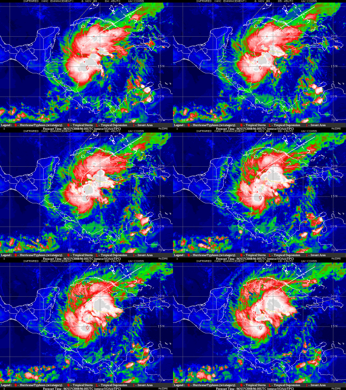
At this point in time, Paloma's appearance really worries me. It looks like all it needs to begin RI would be to get that cloud mass consolidated to the center. They say Cat 2. I'll go on a limb and say that this may become a Category 3/4 borderline with slight weakening before hitting Cuba, but it won't reach Lenny intensity.
0 likes   

User avatar
Chacor
Category 5
Category 5
Posts: 10229
Joined: Mon Oct 02, 2006 10:43 pm
Location: Singapore

#195 Postby Chacor » Thu Nov 06, 2008 6:33 am

Looks like it's the year of the small cyclones. 34-kt winds extend no more than 20 nm (23 mi, 37 km) to the NW of the centre.
0 likes   

O Town
S2K Supporter
S2K Supporter
Posts: 5205
Age: 51
Joined: Wed Sep 07, 2005 9:37 pm
Location: Orlando, Florida 28°35'35"N 81°22'55"W

#196 Postby O Town » Thu Nov 06, 2008 6:58 am

Image
0 likes   

Frank2
Category 5
Category 5
Posts: 4061
Joined: Mon Jul 25, 2005 12:47 pm

#197 Postby Frank2 » Thu Nov 06, 2008 8:22 am

Looks like it's the year of the small cyclones. 34-kt winds extend no more than 20 nm (23 mi, 37 km) to the NW of the centre.


That's due to the bad economy - smaller circulations cost less to maintain...

Kidding...

P.S. I was wrong about the season appearing to be over in early October, but, as a few of us mentioned many times (and, as several at the NHC told me many years ago), the SW Caribbean is favorable for development year-round - there have even been systems forming in this same area in February, so, it's truly the only area in the Atlantic basin that remains favorable for almost all 12 months of the year.

It's really not that surprising, since the SW Caribbean has summer-like temps year-round, so, certainly the water temperature is favorable for development, and, per today's environment, the jet stream is usually to the north of that area...

Frank
0 likes   

tolakram
Admin
Admin
Posts: 19990
Age: 61
Joined: Sun Aug 27, 2006 8:23 pm
Location: Florence, KY (name is Mark)

Re: Re:

#198 Postby tolakram » Thu Nov 06, 2008 8:56 am

jinftl wrote:then why did they shift the track left..

THE FORECAST TRACK IS ADJUSTED TO THE LEFT OF THE
PREVIOUS FORECAST TOWARD THE DYNAMICAL MODEL CONSENSUS

Off season, perhaps an education on what the cone really means would be in order for sure...i am thinking a track can shift left and still be likely to have a right bias if I am understanding correctly...beyond my scope and off topic...all i know, i am eager to see the next forecast track in the am and am truly banking on the total florida miss this weekend...going to a wedding on the beach in islamorada.


It doesn't matter where the track shifts, the cone will move with it because it's just a measure of distance from the track. In other words the cone is not a predictor of where the storm might go, it's a simple error rate that tells them to draw a dashed line so many miles on either side of the track based on past error rates.

Cincinnati, OH has been in the cone of uncertainty as hurricanes have approached the coast. :)

What this points out to me, though, is that just like categories the NHC needs to develop some better warning systems / graphics / information that better informs the public on the true danger of a storm.
0 likes   

User avatar
mitchell
Category 1
Category 1
Posts: 404
Joined: Wed Mar 19, 2003 8:22 am
Location: Delaware
Contact:

Re: ATL: Tropical Depression 17 - Discussion

#199 Postby mitchell » Thu Nov 06, 2008 8:58 am

jlauderdal wrote:Here is a refresher on da cone:

Definition of the NHC Track Forecast Cone

Definition:

The cone represents the probable track of the center of a tropical cyclone, and is formed by enclosing the area swept out by a set of circles (not shown) along the forecast track (at 12, 24, 36 hours, etc). The size of each circle is set so that two-thirds of historical official forecast errors over a 5-year sample fall within the circle. The circle radii defining the cones in 2008 for the Atlantic and eastern North Pacific basins are given in the table below.

One can also examine historical tracks to determine how often the entire 5-day path of a cyclone remains completely within the area of the cone. This is a different perspective that ignores most timing errors. For example, a storm moving very slowly but in the expected direction would still be within the area of the cone, even though the track forecast error could be very large. Based on forecasts over the previous 5 years, the entire track of the tropical cyclone can be expected to remain within the cone roughly 60-70% of the time.

http://www.nhc.noaa.gov/aboutcone.shtml


THIS post and Derek's earlier post saying basically the same thing is just fascinating to me. I had no idea how "disconnected" the cone shape is from current atmospheric dynamics. The cone is really a pretty blunt instrument. Thanks for posting this guys.
0 likes   

User avatar
hurricanefloyd5
Category 5
Category 5
Posts: 1659
Age: 44
Joined: Sun May 02, 2004 10:53 am
Location: Spartanburg
Contact:

Re: ATL: PALOMA - Tropical Storm - Discussion

#200 Postby hurricanefloyd5 » Thu Nov 06, 2008 9:38 am

http://www.ssd.noaa.gov/goes/flt/t1/loop-wv.html

Do anyone think the center is slightly to the west or dose this storm have a multi centers????????
0 likes   


Return to “2008”

Who is online

Users browsing this forum: No registered users and 36 guests