
ATL: PALOMA - Tropical Depression - Discussion
Moderator: S2k Moderators
-
gatorcane

- S2K Supporter

- Posts: 23708
- Age: 48
- Joined: Sun Mar 13, 2005 3:54 pm
- Location: Boca Raton, FL
Re: ATL: PALOMA - Tropical Storm - Discussion
Looking at the latest satellite images, I'm wondering if the GFDL and HWRF are overdoing the intensity and size for Paloma. Paloma does not look like a system that is undergoing RI and seems to be sucking in some dry air from the SW Caribbean. In addition Paloma is moving to the NNE-NE already at a decent speed, a bit faster than guidance. In my opinion, the models showing a weaker/sheared Paloma approaching Cuba and stalling just could be on to something, we will see.
Last edited by gatorcane on Thu Nov 06, 2008 3:06 pm, edited 2 times in total.
0 likes
-
hurricanefloyd5

- Category 5

- Posts: 1659
- Age: 45
- Joined: Sun May 02, 2004 10:53 am
- Location: Spartanburg
- Contact:
Re: ATL: PALOMA - Tropical Storm - Discussion
Are we on wobble watch now because this storm looks to be WOBBLING East abit
0 likes
-
cycloneye

- Admin

- Posts: 149283
- Age: 69
- Joined: Thu Oct 10, 2002 10:54 am
- Location: San Juan, Puerto Rico
Re: ATL: PALOMA - Tropical Storm - Discussion
AT 400 PM EST...2100Z...THE CENTER OF TROPICAL STORM PALOMA WAS
LOCATED NEAR LATITUDE 16.3 NORTH...LONGITUDE 81.8 WEST OR ABOUT 210
MILES...340 KM...SOUTH OF GRAND CAYMAN AND ABOUT 300 MILES...480 KM
...WEST-SOUTHWEST OF MONTEGO BAY JAMAICA.
PALOMA IS MOVING TOWARD THE NORTH NEAR 8 MPH...13 KM/HR. THIS
GENERAL MOTION IS EXPECTED TONIGHT WITH A GRADUAL TURN TOWARD THE
NORTHEAST FORECAST LATE ON FRIDAY.
MAXIMUM SUSTAINED WINDS HAVE INCREASED TO NEAR 65 MPH...100
KM/HR...WITH HIGHER GUSTS. FURTHER STRENGTHENING IS LIKELY AND
PALOMA IS EXPECTED TO BECOME A HURRICANE LATER TONIGHT OR TOMORROW.
0 likes
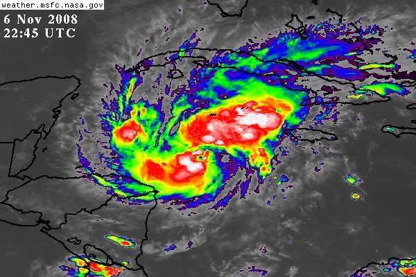
Re: ATL: PALOMA - Tropical Storm - Discussion
A good cirrus deck of Paloma's overhead at this time - it was chilly down here last night (about 60 with high humidity which made it feel chilly), so, it doesn't feel like hurricane season weather...
Frank
Frank
0 likes
Re: ATL: PALOMA - Tropical Storm - Discussion
Still elongated to NE.
Look for possible fast strengthening when it heads more NE and parallel with the shear.
Look for possible fast strengthening when it heads more NE and parallel with the shear.
0 likes

Re: ATL: PALOMA - Tropical Storm - Discussion
Looks like an intensifying hurricane for the Caymans.
0 likes
-
gatorcane
- S2K Supporter
- Posts: 23708
- Age: 48
- Joined: Sun Mar 13, 2005 3:54 pm
- Location: Boca Raton, FL
Re: ATL: PALOMA - Tropical Storm - Discussion
snippet from NWS Miami disco:
LOW LEVEL MOISTURE INCREASES AS WELL BUT BEING ON THE DRY SIDE OF
PALOMA AND WITH SUBSIDENT AIR ALOFT...SHOWERS WOULD BE FAST MOVING
AND LOW TOPPED. GFS POPS SIGNIFICANTLY HIGHER THAN MET AND LEAN
TOWARD THE LOWER THROUGH THE SHORT TERM. GFS INCREASES THETA E
ACROSS THE S AND AT 925 MB SIGNIFICANT MOISTURE ROTATES OVER THE
AREA FROM THE SE. BUT GFS ALSO PLACES PALOMA FURTHER N AND W OF
THE NHC TRACK. SITUATION NEEDS TO BE WATCHED TO SAY THE LEAST.
http://www.srh.noaa.gov/fwd/productview ... &version=0
0 likes


-
jconsor
- Professional-Met

- Posts: 580
- Joined: Mon Jun 30, 2008 9:31 pm
- Location: Jerusalem, Israel
- Contact:
Re: ATL: PALOMA - Tropical Storm - Discussion
Buoy 42057 at 16.8N 81.5W is feeling the brunt of Paloma, with sustained winds of 54 mph, gusts of 70 mph, and pressure down to 997 mb. Paloma will pass about 15-20 miles west of the buoy by about 6 PM EDT.
http://www.ndbc.noaa.gov/station_page.php?station=42057
http://www.ndbc.noaa.gov/station_page.php?station=42057
0 likes
-
Derek Ortt


Re: ATL: PALOMA - Tropical Storm - Discussion
gatorcane wrote:snippet from NWS Miami disco:
LOW LEVEL MOISTURE INCREASES AS WELL BUT BEING ON THE DRY SIDE OF
PALOMA AND WITH SUBSIDENT AIR ALOFT...SHOWERS WOULD BE FAST MOVING
AND LOW TOPPED. GFS POPS SIGNIFICANTLY HIGHER THAN MET AND LEAN
TOWARD THE LOWER THROUGH THE SHORT TERM. GFS INCREASES THETA E
ACROSS THE S AND AT 925 MB SIGNIFICANT MOISTURE ROTATES OVER THE
AREA FROM THE SE. BUT GFS ALSO PLACES PALOMA FURTHER N AND W OF
THE NHC TRACK. SITUATION NEEDS TO BE WATCHED TO SAY THE LEAST.
http://www.srh.noaa.gov/fwd/productview ... &version=0
A rather curious statement from a NWS office that generally downplays most things. A bit strange to me given all forecasts for the storm to be well south and east of SE Fl.
0 likes

Re: ATL: PALOMA - Tropical Storm - Discussion
based on the 71 mph 1-minute sustained wind at the buoy and the gusts to 68 kts...if you surmise that the highest winds were not recored by the buoy that you can find 3 mph somewhere and classify this thing as a hurricane.
0 likes
Re: ATL: PALOMA - Tropical Storm - Discussion
If that's the eye on shortwave IR it just passed very close to the buoy on its west side. I'd estimate it missed the buoy by 10-20 miles and is currently hurricane near the eyewall.
0 likes
Who is online
Users browsing this forum: No registered users and 23 guests