
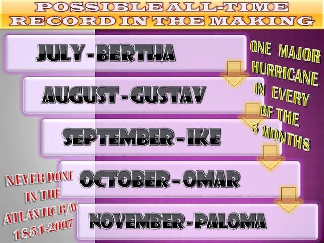
NHC now forecasts Paloma to reach cat 3 status.
FORECAST VALID 08/1200Z 20.0N 80.8W
MAX WIND 100 KT...GUSTS 120 KT.
64 KT... 30NE 30SE 20SW 20NW.
50 KT... 60NE 60SE 40SW 40NW.
34 KT...100NE 100SE 80SW 80NW.
ATL: PALOMA - Tropical Depression - Discussion
Moderator: S2k Moderators
-
wxman57

- Moderator-Pro Met

- Posts: 23172
- Age: 68
- Joined: Sat Jun 21, 2003 8:06 pm
- Location: Houston, TX (southwest)
Re:
Tampa Bay Hurricane wrote:Question about South Florida: Pro-mets or anyone- please help me understand this meteorologically:
the current national weather forecasts show light winds saturday, but if there is a 1020 mb high just NE of FL (as visible on any of the loops when you click "fronts" box it shows the high over the SE US) and a sub-980 Paloma to the SE by Saturday, that would cause a pressure gradient driven strong easterly breeze, wouldn't it?...a couple weeks ago we had
breezy conditions 20-30 mph with just TD 16 in the caribbean and a high north of florida...
so how come the forecasts are not accounting for the easterly wind due to the pressure gradient? Are the
cold front driven SW surface wind vectors (east of front) cancelling out the NE wind Vectors? In that case I could see the light wind
forecast verifying...
(cold front wind) and
pressure gradient wind, do they cancel?
I agree with you, the models I'm looking at (and common sense) say 15-20 kts across south Florida inland and higher on the coast for Saturday. I guess that's "light" compared to a hurricane.
0 likes
-
Tampa Bay Hurricane

- Category 5

- Posts: 5597
- Age: 38
- Joined: Fri Jul 22, 2005 7:54 pm
- Location: St. Petersburg, FL
Re: ATL: PALOMA - Hurricane - Discussion
My prayers to all in the path of this hurricane
_________________________________________________
Edit: Thanks Wxman57! For a question on local weather impact


_________________________________________________
Edit: Thanks Wxman57! For a question on local weather impact

0 likes
-
dixiebreeze

- S2K Supporter

- Posts: 5140
- Joined: Wed Sep 03, 2003 5:07 pm
- Location: crystal river, fla.
Re: ATL: PALOMA - Hurricane - Discussion
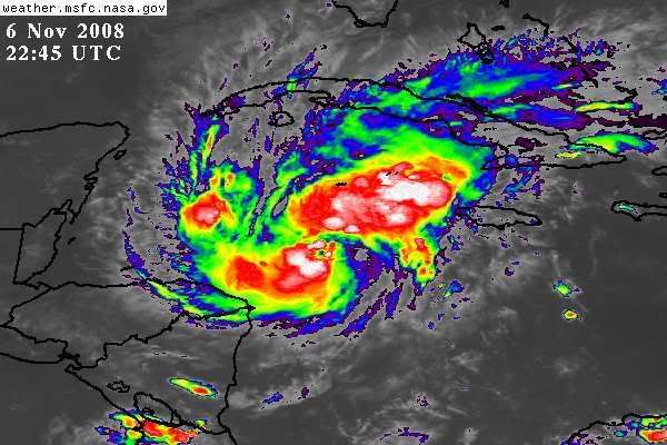
DATE/TIME LAT LON CLASSIFICATION STORM
06/2345 UTC 16.8N 81.7W T4.0/4.0 PALOMA -- Atlantic
06/2345 UTC 16.8N 81.7W T4.0/4.0 PALOMA -- Atlantic
0 likes
-
Tampa Bay Hurricane
- Category 5
- Posts: 5597
- Age: 38
- Joined: Fri Jul 22, 2005 7:54 pm
- Location: St. Petersburg, FL
Re: Re:
wxman57 wrote:Tampa Bay Hurricane wrote:Question about South Florida: Pro-mets or anyone- please help me understand this meteorologically:
the current national weather forecasts show light winds saturday, but if there is a 1020 mb high just NE of FL (as visible on any of the loops when you click "fronts" box it shows the high over the SE US) and a sub-980 Paloma to the SE by Saturday, that would cause a pressure gradient driven strong easterly breeze, wouldn't it?...a couple weeks ago we had
breezy conditions 20-30 mph with just TD 16 in the caribbean and a high north of florida...
so how come the forecasts are not accounting for the easterly wind due to the pressure gradient? Are the
cold front driven SW surface wind vectors (east of front) cancelling out the NE wind Vectors? In that case I could see the light wind
forecast verifying...
I agree with you, the models I'm looking at (and common sense) say 15-20 kts across south Florida inland and higher on the coast for Saturday. I guess that's "light" compared to a hurricane.
Oh ok thanks! The forecasts were saying 3 to 11 mph wind Saturday for my location:
which is why I was confused, usually they say 16-18 mph east wind with gusts to 24 mph
or something like that...during pressure gradient situations
http://forecast.weather.gov/MapClick.ph ... &map.y=156
But I found that 15-20 kt forecast: http://forecast.weather.gov/shmrn.php?mz=gmz086
0 likes
-
Tampa Bay Hurricane
- Category 5
- Posts: 5597
- Age: 38
- Joined: Fri Jul 22, 2005 7:54 pm
- Location: St. Petersburg, FL


-
gatorcane

- S2K Supporter
- Posts: 23708
- Age: 48
- Joined: Sun Mar 13, 2005 3:54 pm
- Location: Boca Raton, FL
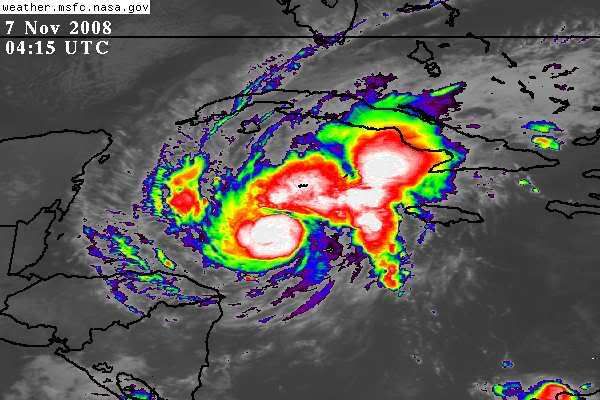
so there definitely is a bit of a more NNW movement over the past couple of hours but that is because there is a very narrow ridge passing by over the Southern GOM and Florida headed east as the big trough comes through...and Paloma has deepened so much it is feeling that a little I would guess.
You can see in the IR loop the eye coming out and it wobbling more NNW over the past couple of hours:
http://www.ssd.noaa.gov/goes/east/watl/loop-avn.html
click this link and hit the FWD button to see the ridge over FL buts collapsing and moving east fast
http://moe.met.fsu.edu/cgi-bin/ukmtc2.c ... =Animation
I have to admit, its moving faster than I thought and faster than some of the model guidance.
It should be back on a more N or NNE course soon as the ridge totally collapses over FL and the trough swings through.
0 likes


Re:
If the latest NGPS model has its way.... it will be breezy indeed for you on the FL West Coast!!!

Tampa Bay Hurricane wrote:Question about South Florida: Pro-mets or anyone- please help me understand this meteorologically:
the current national weather forecasts show light winds saturday, but if there is a 1020 mb high just NE of FL (as visible on any of the loops when you click "fronts" box it shows the high over the SE US) and a sub-980 Paloma to the SE by Saturday, that would cause a pressure gradient driven strong easterly breeze, wouldn't it?...a couple weeks ago we had
breezy conditions 20-30 mph with just TD 16 in the caribbean and a high north of florida...
so how come the forecasts are not accounting for the easterly wind due to the pressure gradient? Are the
cold front driven SW surface wind vectors (east of front) cancelling out the NE wind Vectors? In that case I could see the light wind
forecast verifying...
0 likes

Re: ATL: PALOMA - Hurricane - Discussion
yeah my local met (SE FL) is not convinced that FL is in the clear yet
0 likes
-
Tampa Bay Hurricane
- Category 5
- Posts: 5597
- Age: 38
- Joined: Fri Jul 22, 2005 7:54 pm
- Location: St. Petersburg, FL
-
wxman57
- Moderator-Pro Met
- Posts: 23172
- Age: 68
- Joined: Sat Jun 21, 2003 8:06 pm
- Location: Houston, TX (southwest)
Re:
Tampa Bay Hurricane wrote:I hope that NOGAPS does Not verify...I'll consider that the outlier and
hope the trough swings this thing away from the West FL Coast....
There aren't many models that are worse than NOGAPS for hurricanes. For the past few days, it had Paloma moving SW through Nicaragua. Now it moves it north into an 80 kt westerly jet stream. If you look at it here, it actually dissipates it to a remnant low north of Cuba, though.
http://moe.met.fsu.edu/cgi-bin/ngptc2.c ... =Animation
Florida is in the clear.
0 likes

Re: ATL: PALOMA - Hurricane - Discussion
Wxman57 do you think Haiti is going to have disasterous floods from Paloma?
0 likes
Re: Re:
understandably, given the storms strengthening and current heading.... and then add in our recent history with a storm in a similar location and time of year (Wilma), it does give some floridians a bit of an uneasy feeling...kind of like watching a speeding train coming right at you, and you know the train will turn before it hits you (as long as it doesn't jump the tracks), but it is a bit unsettling to say the least, until it does turn!
until it is north and east of florida, many here won't truly breathe a sigh of relief.
NWS Miami hasn't sounded the 'all clear'...more of a 'keep an eye' and make sure nothing changes with the forecast mindset...
NATIONAL WEATHER SERVICE MIAMI FL
AREA FORECAST DISCUSSION...UPDATED
ISSUED 637 PM EST THU NOV 6 2008
BUT GFS ALSO PLACES PALOMA FURTHER N AND W OF
THE NHC TRACK. SITUATION NEEDS TO BE WATCHED TO SAY THE LEAST.
A WEAKENING COLD FRONT ASSOCIATED WITH THE MIDWEST TROUGH WILL MOVE
THROUGH S FL LATE IN THE WEEKEND OR EVEN EARLY NEXT WEEK. LITTLE
IMPACT TO S FLA THOUGH WITH THE FRONTAL PASSAGE. HIGH PRES REBUILDS
ACROSS THE E U.S. AND EASTERLY WINDS DEEPEN WITH NOCTURNAL SHOWERS
AFFECTING MAINLY THE E COAST.
Technically, south florida won't be 'in the clear' for too much longer...cloud band approaching....so we are more likely to be 'in the cloudy' with Paloma...

And here, we are 'in the green' for ts wind probabilities...

until it is north and east of florida, many here won't truly breathe a sigh of relief.
NWS Miami hasn't sounded the 'all clear'...more of a 'keep an eye' and make sure nothing changes with the forecast mindset...
NATIONAL WEATHER SERVICE MIAMI FL
AREA FORECAST DISCUSSION...UPDATED
ISSUED 637 PM EST THU NOV 6 2008
BUT GFS ALSO PLACES PALOMA FURTHER N AND W OF
THE NHC TRACK. SITUATION NEEDS TO BE WATCHED TO SAY THE LEAST.
A WEAKENING COLD FRONT ASSOCIATED WITH THE MIDWEST TROUGH WILL MOVE
THROUGH S FL LATE IN THE WEEKEND OR EVEN EARLY NEXT WEEK. LITTLE
IMPACT TO S FLA THOUGH WITH THE FRONTAL PASSAGE. HIGH PRES REBUILDS
ACROSS THE E U.S. AND EASTERLY WINDS DEEPEN WITH NOCTURNAL SHOWERS
AFFECTING MAINLY THE E COAST.
Technically, south florida won't be 'in the clear' for too much longer...cloud band approaching....so we are more likely to be 'in the cloudy' with Paloma...
And here, we are 'in the green' for ts wind probabilities...
wxman57 wrote:Tampa Bay Hurricane wrote:I hope that NOGAPS does Not verify...I'll consider that the outlier and
hope the trough swings this thing away from the West FL Coast....
There aren't many models that are worse than NOGAPS for hurricanes. For the past few days, it had Paloma moving SW through Nicaragua. Now it moves it north into an 80 kt westerly jet stream. If you look at it here, it actually dissipates it to a remnant low north of Cuba, though.
http://moe.met.fsu.edu/cgi-bin/ngptc2.c ... =Animation
Florida is in the clear.
0 likes
-
Matt-hurricanewatcher
Re: ATL: PALOMA - Hurricane - Discussion
Looks to be around 80-85 knots now. I think 100 knots is possible,,,We will see of course!
0 likes

Who is online
Users browsing this forum: No registered users and 64 guests